By the end of winter, I can’t wait to start backpacking again. BC’s mountainous terrain, however, means that many popular backpacking routes are under snow until at least June. But not all of them!
Keep reading to discover 13 of the best shoulder season backpacking trips in BC. I’ve personally hiked most of those features, with the few remaining on my ‘to do’ list.
No matter which shoulder season backpacking trail you choose to hike, it should help scratch that multi-day adventure itch before the snow melts on the higher ranges!

Backcountry necessities
- Always bring the 10 Essentials
- Know how to stay safe in the backcountry
- Remember to Leave No Trace to help keep the wilderness wild
- Understand how to avoid negative bear encounters
- Trying out backpacking for the first time? Read Backpacking 101
- Check out our packing guide with gear recommendations
- Sign up to our newsletter for a free backpacking checklist

Shoulder season hiking in British Columbia
The peak time for hiking in BC is the summer season, from late June to early September. There are a number of reasons for this – the two most important being:
- Warmer, drier weather
- Less snow on hiking trails
British Columbia is an exceptionally mountainous province and many popular backpacking trails are still under snow until June or July.
Some high elevation hikes can still have snow into August, depending on the year. And, of course, winter returns early to the mountains.
The backpacking trips mentioned in this post are primarily coastal or low elevation trails that can be safely hiked during the shoulder season. This means that they are likely (but not guaranteed) to be snow-free during this time.

Trail conditions during the shoulder season
BC’s weather can be somewhat unpredictable, especially in the shoulder season months. Some years, spring is warm and dry. Other years, it stays cold and the snow pack lingers.
To find out if a trail is snow-free, I usually check:
- The relevant BC Parks’ webpage for trail updates
- Facebook hiking groups for recent photos/experiences
- AllTrails, for latest reports
With all three sources, I use the information given as a guideline as what to expect as weather can change so quickly.
The good news is that Vancouver Island’s coastal trails are usually snow-free all year round. So, if you’re local to the Island, you’re in luck!
It is important to know, however, that shoulder season backpacking does have other hazards.
Temperatures are usually lower. Rain should be expected. Hiking trails may be muddy or flooded, with fallen trees and other debris on the path itself. Trail maintenance sometimes doesn’t start until summer.

Shoulder season backpacking trips in BC
And here’s the list you’ve been waiting for! Twelve shoulder season BC backpacking trips, ranging from short overnight trips to epic week long adventures.
This post includes one affiliate link. If you make a purchase via this link, I may receive a small percentage of any resulting sales at no extra cost to you.
Cape Scott Trail
Length: 47km return, 103m total elevation gain
Where: North Coast of Vancouver Island
Snow-free: Almost all year round
Camping: 6 designated camping areas on or close to the trail
Fees/reservations: $10/per person/per night (1st May to 30th Sept), first come first serve
Dogs: Not permitted
Suggested length of trip: 2 to 4 days
More info: Ultimate Cape Scott Hiking Guide
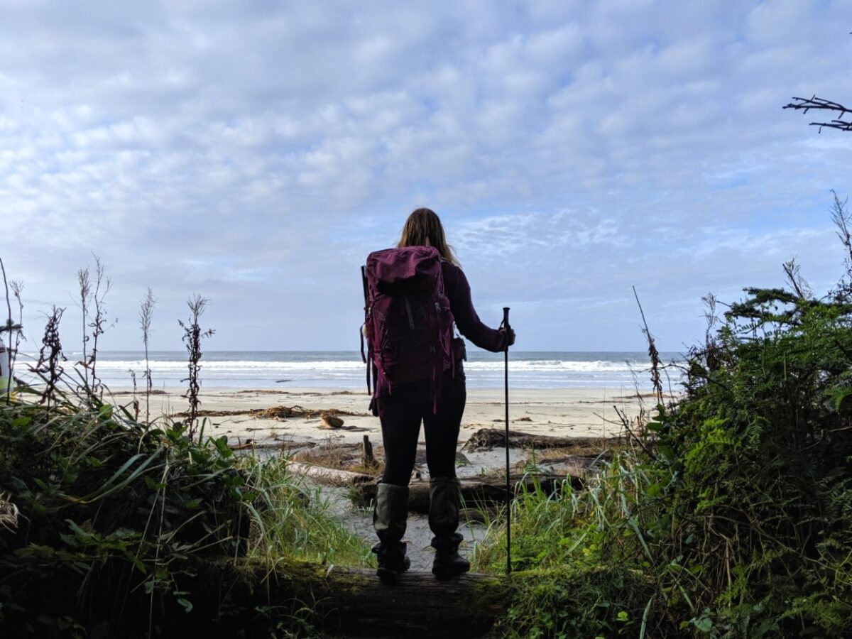
The Cape Scott Trail is a worthwhile adventure to very northwestern corner of Vancouver Island. Along the way, you can expect to marvel at beautiful old growth forest, spectacular sandy beaches and fascinating historical artefacts.
Nels Bight (16.8km) is one of the highlights of the trail, featuring 2400m of sweeping golden sand and the chance to see spectacular sunsets. Many hikers choose to base camp here and visit the Cape Scott Lighthouse (the trail’s final destination) as a day trip.
Cape Scott Provincial Park is one of the wettest places in British Columbia and so hikers should be prepared to traverse slippery boardwalks and swathes of mud, especially in the shoulder seasons.
San Josef Bay
Length: 5km return hike with minimal elevation gain/loss
Where: North Coast of Vancouver Island
Snow-free: Almost all year round
Camping: Beach and forest campsites
Fees/reservations: $10/per person/per night (1st May to 30th Sept), first come first serve
Dogs: Permitted
Suggested length of trip: 2 to 3 days
More info: San Josef Bay Guide
It may be one of the shortest shoulder season backpacking trips in BC mentioned here but San Josef Bay is a great destination for testing new gear or introducing a friend to multi-day hiking.
San Josef Bay is a very small taster of the Cape Scott Trail, with all of the beauty and far less of the effort…and mud!
The forest trail to San Josef Bay is mostly flat, wide and easy to traverse. The Bay itself features a gorgeous stretch of golden sand, divided into two by a headland.
At low tide, it is possible to traverse between the beaches easily and marvel at the ocean-eroded sea stacks that tower towards the sky. Camping at San Josef Bay is on the beach or in the bordering forest.

North Coast Trail (NCT)
Length: 59.5km one-way hike with 243m elevation gain
Where: North Coast of Vancouver Island
Snow-free: Almost all year round
Camping: 7 designated campsites on the trail
Fees/reservations: $10/per person/per night (1st May to 30th Sept), first come first serve
Dogs: Not permitted
Suggested length of trip: 5 days for main trail
More info: North Coast Trail guide
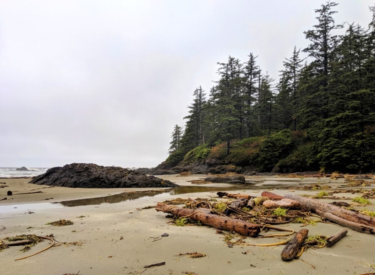
If San Josef Bay is the lite Cape Scott Trail, the North Coast Trail is the hard version. It’s a truly wet and wild journey along the the northern coastline of Cape Scott Provincial Park, alternating between beach and rainforest sections.
The North Coast Trail is as wet as it is challenging. Think knee-deep mud, slippery tree roots, creek crossings, fallen trees and even a couple of fixed ropes to ascend tricky slopes. The NCT is is a bit like the West Coast Trail’s northern, more rugged and remote cousin.
The rewards are, however, numerous. The old growth forest is stunning, as are the beaches.
Solitude is a given, considering how many people attempt the trail. Wildlife sightings are common, with the possibility of seeing whales, black bears, eagles, seals and even wolves.
Please note that hiking the North Coast Trail is significantly more difficult in May and June compared to the drier months of July and August. Plan for a longer itinerary (five/six days vs. standard four days).

Raft Cove
Length: 4km return
Where: Northwestern Vancouver island
Snow-free: Almost all year round
Camping: Beach and forest campsites
Fees/reservations: $5/per person/per night (1st May to 30th Sept), first come first serve
Dogs: Not recommended
Suggested length of trip: 2 to 3 days
For more info: BC Parks’ website
This is the shortest shoulder season BC backpacking trip in this list but it’s absolutely worthwhile if you love remote, off the beaten path destinations.
Raft Cove itself is a gorgeous, 2km long windswept white sand beach backed by temperate rainforest.
The 2km hike into Raft Cove shouldn’t be taken lightly due to the (usually unmaintained) trail being exceptionally muddy, slippery and rooty. There are often big pools of standing water. Expect to take around 45-50 minutes to hike the trail.
Once reaching the beach, you have a choice of camping on the beach or in the forest by the Macjack River. The latter has rustic tent pads and better shelter.
Nootka Trail
Length: 35km one-way, 520m elevation gain
Where: Nootka Island, off the West Coast of Vancouver Island
Snow-free: Almost all year round
Camping: 6 unofficial campsites (no facilities)
Fees/reservations: $50 per person user fee charged by Mowachaht/Muchalaht First Nations
Dogs: Not recommended
Suggested length of trip: 4 to 6 days
For more info: Complete Nootka Trail Guide
The Nootka Trail follows a section of the coastline of Nootka Island, a large landmass on the western side of Vancouver Island. Solitude is the main appeal here, with the trailheads only being accessible by seaplane and boat.
Hikers that make the effort to reach this trail will find expansive ocean views, scenic stretches of beach hiking, frequent wildlife encounters and an insight into First Nation culture.
The terrain is varied, with challenging sections featuring fallen trees, steep slopes (aided by rope), deep mud, creek crossings, tidal lagoons and slippery rocks.
We hiked the Nootka Trail in mid September and saw zero other hikers. It’s important to time it right, however – the week before more than one metre of rain fell on the trail.

Hesquiat Peninsula Trail
Length: 50km one way
Where: West Coast of Vancouver Island
Snow-free: Almost all year round
Camping: No established campsites
Fees/reservations: None
Dogs: Not recommended
Suggested length of trip: 4 to 5 days
For more info: Tim Leadem’s Hiking the West Coast of Vancouver Island book
If you thought that the Nootka Trail was remote, get prepared for the Hesquiat Peninsula! The northern trailhead, Escalante, is a short water-taxi journey south-west of Yuquot, on Nootka Island (or a seaplane flight from Gold River).
Besides the isolation, the Hesquiat Peninsula Trail is particularly special as most of the route is directly on the shoreline.
The path is exceptionally varied, traversing sandstone rock shelves, tide pools, rocky cliffs, pebble beaches, pocket coves, boulders and beautiful stretches of sand.
Although the total elevation difference of the trail is low, each day of hiking does include plenty of small ups and downs. But you’ll likely be distracted by the incredible coastal scenery anyway!
Juan de Fuca Trail
Length: 47km one-way hike with 1587m elevation gain
Where: West Coast of Vancouver Island
Snow-free: Almost all year round
Camping: 6 established campsites
Fees/reservations: $10/per person/per night, first come first serve
Dogs: Not recommended
Suggested length of trip: 4 days
For more info: Juan de Fuca Trail Guide
The Juan de Fuca Trail stays close to the Pacific coastline of Vancouver Island, featuring spectacular beaches, sweeping ocean views, temperate rainforest, rocky coves and coastal cliffs. There even a hidden waterfall to find along the way.
Most of the camping areas have beach access (or indeed, camping opportunities right on the beach), which offers the potential of whale watching and unforgettable sunsets.
Often described as a shorter and less restrictive version of the West Coast Trail, the Juan de Fuca Trail is surprisingly challenging. There are no ladders here, but still plenty of difficult terrain to cover. And, of course, a similar amount of mud!
The full Juan de Fuca Trail will reopen on 1st July 2026 after a prolonged closure due to storm damage. See advisories for more details.

West Coast Trail (WCT)
Length: 75km with 1508m elevation gain
Where: West Coast of Vancouver Island
Snow-free: Almost all year round
Camping: 13 designated campgrounds plus paid and unofficial options
Fees/reservations: $24.50 reservation fee, $130.31 trail fee, $40 ferry fees
Dogs: Not permitted
Suggested length of trip: 6 to 8 days
For more info: Complete West Coast Trail Guide
The West Coast Trail (WCT) follows ancient First Nation paths along the remote and rugged Pacific coastline of Vancouver Island.
This legendary route is both beautiful and challenging, with 100+ vertical ladders and plenty of mud alongside beautiful beaches, pristine waterfalls and gnarly old growth forest.
The popularity of the WCT means that access is severely restricted, with a limited number of hikers allowed to start the West Coast Trail each day from the three trailheads (Pachena Bay, Gordon Bay, Nitinaht Narrows). Reservations are therefore required.
The West Coast Trail also has a strict operating season, meaning that it is only open from 1st May to 30th September. I have included it in this list since it is open for at least three of the shoulder season months.
Read Next: How to Reserve Backcountry Camping in BC – Essential Details and Dates

Wildside Trail
Length: 11km one-way, minimal elevation gain
Where: West Coast of Vancouver Island
Snow-free: Almost all year round (operating season is May to October)
Camping: 3 designated campsites
Fees/reservations: $15 permit fee and $10.00 per person, per night camping fee
Dogs: Not recommended
Suggested length of trip: 2 to 3 days
For more info: Wildside Trail website
The Wildside Trail follows traditional paths used by the First Nation community on Flores Island for thousands of years.
A true coastal hike, the trail stays close to the ocean for almost the entire length, only bypassing into the bordering ancient Sitka forest when navigationally necessary.
Being relatively short and easy in hiking difficulty, the Wildside Trail is usually hiked as a 22km return route from the Ahousaht trailhead.
Not only does this mean you get to experience the trail from both directions but you can also visit beautiful Whitesand Cove twice!
Flores Island may feel like a world away but is relatively close to Tofino, accessible via a 30 minute boat ride or 10 minute seaplane flight. There is a relatively inexpensive scheduled water taxi service ($20).
Sunshine Coast Trail (SCT)
Length: 180km thru-hike
Where: Sunshine Coast from Sarah Point to Saltery Bay
Snow-free: May to October
Camping: 14 huts plus a number of established camping areas
Fees/reservations: No fees, first come first serve
Dogs: Permitted
Suggested length of trip: 9 to 14 days for full length
For more info: Ultimate Sunshine Coast Trail Guide
The Sunshine Coast Trail leaders hikers through old growth forest, to the top of mountains and close to rugged coastal shorelines. While the full length is 180km, it can easily be hiked in shorter sections.
Being Canada’s longest ‘hut-to-hut’ trail, there are 14 cosy shelters located along the SCT, plus additional camping opportunities. This makes it particularly suitable for shoulder season trips when the weather is less reliable.
The elevation of the trail varies quite widely, with the route featuring many ups and downs. The highest points are Walt Hill (1082m), Tin Hat Mountain (1193m) and Mount Troubridge (1297m). Depending on the year, snow may linger here into May. Check the Sunshine Coast Trail Facebook group for updates.
For early or late shoulder season backpacking, I’d recommend the first section from Sarah Point to Townsite (Powell River). This part of the trail is usually snow-free almost year round. The distance is around 50km with an ideal trip length of 3-4 days.
Skagit River Trail
Length: 15km one way (with vehicle shuttle) or 30km return, minimal elevation gain
Where: Near Hope
Snow-free: April to October
Camping: 2 designated campgrounds
Fees/reservations: No fees, first come first serve
Dogs: Not recommended
Suggested length of trip: 2 to 3 days
For more info: BC Parks description (from Sumallo trailhead)
The Skagit River Trail follows a section of the historic gold-rush era Whatcom Trail. This mellow hike may not feature any dramatic scenery but it does traverse through the Skagit River Cottonwoods Ecological Reserve, home to some beautiful old growth forest.
The path stays close to the river almost the whole way, providing some lovely peek through views of the rushing water. If you time it right (late May/June), you’ll get to the unusual sight of blooming see rhododendrons.
The Skagit River Trail has two trailheads – one in Skagit Valley Provincial Park (south) and the other in Manning Provincial Park (north). The Delacy campsite is located 10.5km from the southern trailhead, making it an ideal place to stay overnight from this direction. The other campsite, Harlequin Flats, is approximately 12km from the northern trailhead.
Please note that this trail was damaged from flooding in November 2021. Fording the river may be required.
Lower Stein Valley
Length: 13km one-way, 360m elevation gain
Where: Near Lytton
Snow-free: March to October
Camping: 5 established campsites
Fees/reservations: No fees, first come first serve
Dogs: Not recommended
Suggested length of trip: 2 to 4 days
For more info: Stein Valley Park Guide by IntoCascadia
Sheltered by the Coast Mountains, the Lower Stein Valley escapes much of the snow that falls in the surrounding area. This makes it an excellent destination for shoulder season backpacking trips in BC.
The Lower Stein Valley Trail is part of the epic 90km Stein Traverse, an alpine route that intersects Stein Valley Nlaka’pamux Heritage Park. The Lower Valley section comprises 30km of trail to Cottonwood Creek. There are eight campgrounds, located at regular intervals.
The first 13km to the Suspension Bridge campsite is the most used and maintained part of the trail. This offers day hiking opportunity as well as the option to continue and camp further up the valley if conditions allow.
The highlights of the Lower Stein Valley include the ponderosa pine forest surrounding the trail, intermittent views of the river and surrounding peaks plus some interesting First Nations cultural sites
The Lower Stein Valley was impacted by wildfires in 2023. The Stein Valley Trail is currently closed west of Earl’s Camp (10.5km from trailhead). Check the BC Parks webpage for updates.
Divide Lake
Overview: Lakeside campsite reached by short but moderately challenging hike
Where: Okanagan Valley
Snow-free: May to late October
Camping: Designated campgrounds at Divide Lake
Fees/reservations: No fees, first come first serve
Dogs: Not recommended
Suggested length of trip: 2-3 days
For more info: Complete Okanagan Mountain Park Guide
Rugged Okanagan Mountain Provincial Park rises high above Okanagan Lake, just across from Peachland.
Hiking offers peek through views of the sun drenched landscape as well as Okanagan Lake. Shoulder season is an ideal time to visit as the summer months are HOT with little to no shade.
Divide Lake is a long, narrow lake sitting behind Okanagan Mountain (1576m). It is accessible via two hiking routes – the Divide Lake Trail from Rimrock Gate, Kelowna (9.5km, 950m elevation gain) and the Mountain Goat Trail from the southern parking lot, Naramata (5km, 550m elevation gain).
Divide Lake isn’t the only shoulder season backpacking trip in Okanagan Mountain Provincial Park. There are also designated campgrounds at Baker Lake (4km round trip from Divide Lake) and along the shore of Okanagan Lake, accessed by the Wildhorse Canyon Trail.
Shoulder season multi-day paddling trips in BC
This post may primarily be about shoulder season backpacking in BC, but I thought it was also worth briefly mentioning multi-day paddling trips.
Most of our own paddling trips happen in late spring while we wait for the main backpacking season to begin.
Weather conditions on the water can change quickly. It goes without saying that you should have knowledge of the dangers of cold water and rescue techniques.

Sayward Forest Canoe Circuit
Overview: Full 47km circuit of 12 lakes connected by 12 portages
Where: Vancouver Island
Camping: 37 camping areas
Fees/reservations: Most (but not all) campgrounds are free, with first come first serve system used
Boat launches: Multiple, but Mohun Lake is popular
Dogs: Permitted
Suggested length of trip: 4 days
Read More: Sayward Forest Canoe Circuit Paddling Guide

Main Lakes Canoe Route, Main Lake Provincial Park
Overview: Group of six connected lakes on Quadra Island, with Main Lake being the largest
Where: Quadra Island
Camping: 7 established marine campgrounds, mostly on Main Lake
Fees/reservations: $5/per camping night/per person, first come first serve
Boat launches: Mine Lake or Village Bay Lake
Dogs: Not recommended
Suggested length of trip: 2-4 days
Wallace Island
Overview: Long, narrow island located just off the coast of Salt Spring Island
Where: Gulf Islands
Camping: 3 established marine campgrounds
Fees/reservations: $5/per camping night/per person, first come first serve
Boat launches: Multiple, but Hudson Point and Southey Point are convenient
Dogs: Not recommended
Suggested length of trip: 2-4 days
Read More: Wallace Island, An Idyllic Kayaking Destination
Powell Forest Canoe Route
Overview: 8 lakes connected by 5 portages, arranged in a horseshoe shape
Where: Sunshine Coast
Camping: 17 designated camping areas, located around route
Fees/reservations: No fees, first come first serve
Boat launches: Multiple but Lois Lake is popular
Dogs: Permitted
Suggested length of trip: 4-6 days
Read More: Paddling the Powell Forest Canoe Route
Desolation Sound Provincial Park
Overview: Ocean paddling in and around Desolation Sound Provincial Park, with protected bays, towering rock bluffs and idyllic islands
Where: Sunshine Coast
Camping: 11 designated camping areas within the provincial park plus informal camping areas
Fees/reservations: $5/per camping night/per person (1st June to 15th September only), first come first serve
Boat launches: Multiple but Okeover Arm and Lund are popular
Dogs: Not recommended
Suggested length of trip: 3-5 days
Read More: Ultimate Desolation Sound Paddling Guide
Indian Arm, Say Nuth Khaw Yum Provincial Park
Overview: 18km fjord extending north from Burrard Inlet
Where: Vancouver
Camping: 3 designated camping areas – Twin Islands, Bishop Creek and Granite Falls
Fees/reservations: No fees, first come first serve
Boat launches: Cates Park (North Vancouver Municipal Park) or Deep Cove
Dogs: Not recommended
Suggested length of trip: 2-3 days
Okanagan Lake, Okanagan Mountain Provincial Park
Overview: 135km long lake, with shoreline of middle section part of a provincial park
Where: Okanagan Valley, across from Peachland
Camping: 7 designated marine campgrounds
Fees/reservations: $13/per night/per camping party, first come first serve
Boat launches: Multiple boat launch locations, Indian Rock near Naramata is one of the closest
Dogs: Not recommended
Suggested length of trip: 2-4 days
Read Next: 17 of the Best Canoe Trips in British Columbia

More BC backpacking inspiration
BC’s Best Backpacking Trips: Our Favourites and 60+ More Options
25 of the Best Overnight Backpacking Trips in British Columbia
How to Reserve Backcountry Camping in BC: Essential Details and Dates
Backpacking trail guides
Lake O’Hara, Yoho National Park
Della Falls, Strathcona Provincial Park
Cape Scott Trail, Cape Scott Provincial Park
HBC Trail from Hope to Tulameen
Magog and Og Lake, Mount Assiniboine Provincial Park
Heather Trail, Manning Park
Eva Lake, Mount Revelstoke National Park
Sunshine Coast Trail
Gwillim Lakes and Gimli Peak, Valhalla Provincial Park


One half of the Canadian/British couple behind Off Track Travel, Gemma is happiest when hiking on the trail or planning the next big travel adventure. JR and Gemma are currently based in the beautiful Okanagan Valley, British Columbia, Canada. Consider buying us a coffee if you have find any of our guides helpful!