The 35km Nootka Trail offers a wild coastal backpacking experience along what feels like the edge of the Earth.
There are no formal campgrounds and no reservation system, just an untamed path winding its way through old growth forests, up and over rocky headlands and along spectacular stretches of beach.

The majestic yet unrelenting Pacific Ocean is the backdrop to it all. Most hikers spend 4-7 days traversing this stunning landscape.
Seeing wildlife is almost a given, with this bountiful coastline being a favourite with bears and wolves. There’s a chance to see whales too, including humpbacks and greys.
Best of all, you may have it all to yourself. We didn’t see a single other hiker during our five day Nootka Trail adventure.
For this reason and many more, the Nootka Trail is one of my all time favourite coastal hiking trails. And we’ve done quite a few now, including the North Coast Trail, Juan de Fuca and the famous West Coast Trail.

Read on to discover more about the Nootka Trail with our trip report and comprehensive hiking guide, based on our own experience.
This is a pretty comprehensive (read: long) post, so here’s the breakdown:
Nootka Trail
Location: Nootka Island, near Vancouver Island in British Columbia
Distance: 35km
Elevation change: Minimal
Hike type: One-way
Time: 4-6 days
Difficulty: Moderate
Dogs: Not recommended

Backpacking necessities
Before attempting the Nootka Trail:
- Remember to bring the 10 Essentials
- Know how to stay safe and also avoid negative bear encounters
- Understand how to Leave No Trace to help keep the Nootka Trail beautiful for humans and wildlife
- Be prepared to pack out everything you bring with you
- Check out our recommended gear for backpacking
- Need a backpacking checklist? Sign up to our newsletter for a free one

About the Nootka Trail
The Nootka Trail is located on the western edge of Nootka Island. It travels through three First Nation reserves, with the rest being crown land.
Nootka Island itself sits just off the northwestern coast of Vancouver Island, British Columbia, Canada.
Despite its remote location, Nootka Island had a prominent role in the creation of British Columbia as we know it today. Learning more about this will undoubtedly enhance your Nootka Trail adventure (as it did mine!)

Land of the Nuu-chah-nulth people
The passage of water between Vancouver Island and Nootka Island is called Mowichat by the Nuu-chah-nulth people, who have lived in this area for thousands of years.
In English, we call it Nootka Sound. I’ll explain why in a second.
Nuu-chah-nulth means ‘all along the mountains and sea’ and includes members of fifteen nations along this coastline.
Yuquot – the center of the world
The village of Yuquot is located on the southeastern tip of Nootka Island and is the ancestral home of the Mowachaht-Muchalat First Nation. They consider it to be the ‘center of the world.’
Yuquot means ‘where the wind blows from all directions’ in the Mowachaht/Muchalat language. The village sits on a peninsula, between two beaches.
Considered the capital for the Nuu-chah-nulth nations, Yuquot was also the place where whaling, an integral part of Nuu-chah-nulth culture, originated and developed.

The arrival of the British and Spanish
In 1774, Spanish explorer Juan José Pérez Hernández arrived off the shore of Yuquot and called it ‘Santa Cruz.’ The surrounding area was quickly claimed by the Spanish.
In 1778, Captain James Cook became the first European to land on shore. The Yuquot villagers instructed Cook to nuutkaa (‘go around’) with his ship into the harbour.
Interpreting the word ‘nuutkaa‘ as a reference to the area, Cook renamed the inlet Nootka Sound and its inhabitants as the Nootka people.
Friendly Cove
Over the next few years, Yuquot became known as Friendly Cove by European traders and explorers. Protected by a group of small islands, Yuquot provided an excellent safe habour for ships.
As Yuquot grew into an important trade centre (particularly for sea otter pelts), as did the colonial interests of the British and Spanish.
In 1789, the Spanish established a fort and settlement called Santa Cruz de Nuca in agreement with ta’yii ha’wilth (Chief) Maquinna. It was the only Spanish settlement ever established in Canada.

The Nootka Crisis
Not long after the building of Santa Cruz de Nuca, the Spanish seized three British trading ships and sparked the Nootka Crisis. This led Britain and Spain to the brink of war.
Intense negotiations (and a refusal from France to assist Spain) resulted in the signing of the Nootka Conventions in the 1790s.
Both Britain and Spain agreed to mutually abandon plans for permanent settlements in Nootka Sound. Spain also rescinded colonial expansion in the Pacific North West.
As part of the process, appointed commissioners George Vancouver from Britain and Juan Francisco de la Bodega y Quadra from Spain travelled and stayed in Yuquot under the hospitality of ta’yii ha’wilth Maquinna.
Yuquot and the Nootka Trail today
More than 90% of the Nuu-chah-nulth died of infectious diseases in the years following European contact. The population today is around 8,000.
Up until the 1960s, there was still a strong Mowachaht-Muchalat community living in Yuquot. In 1965, the federal government moved many members to a reserve in Gold River.
At the time of our visit, just two people lived in Yuquot full time – Ray and Darryll Williams. Unfortunately, Ray passed away on 31st October 2022.
For the last two summer hiking seasons, an on-demand BBQ takeout was operated in Yuquot by Sugar Williams, offering burgers, hot dogs, fried fish, smokies, chips and more.
Look for the two story house across the field to the left on arrival in Yuquot and ask for Sugar. Debit/credit is usually accepted as well as cash. Closed Sunday and Monday.
The Mowachaht-Muchalat First Nation welcome visitors to Yuquot and plan to develop more tourist facilities.
Yuquot was designated a National Historic Site of Canada in 1923. The Nootka Lighthouse on San Rafael Island was built in 1958.

Hiking the Nootka Trail: Our experience
Before getting into the trail guide, I’m going to share an overview of our own hike on the Nootka Trail in September 2021. If you like, you can skip ahead to the trail guide.
We hiked the Nootka Trail with Leigh from HikeBikeTravel and her husband John. Leigh has written her own Nootka Trail guide so I’d recommend reading that for her perspective.
For each day of hiking, I have provided our total time as well as moving time. Most days, we stopped for lunch (45 minutes to 1 hour) as well as a couple of shorter breaks.
We hiked the West Coast Trail just a few months before the Nootka Trail. The experience was dramatically different in many ways. For one, we saw no other hikers during our entire five day trip on the Nootka Trail.


Day 1 – Starfish Lagoon to First Beach
Distance: 1km
Total Time: 45 minutes
Moving time: 45 minutes
Truly the most exciting way to start our hike, our Nootka Trail experience started with a 45 minute seaplane flight. It was sunny too, a huge surprise after Vancouver Island had received such huge amounts of rain in the preceding days.
We followed Muchalat Inlet all the way to Bligh Island and then across Nootka Sound, over the village of Yuquot and then alongside the Nootka Trail route itself.
As we started descending into Starfish (Louie) Lagoon, we were treated to a glimpse of the shipwrecked remains of Greek freighter Treis Lerarchi.

Stepping directly into the ocean from the seaplane was an interesting experience. Luckily, it was only shin deep.
With the bags carried to shore, JR and John gave the seaplane a push and our pilot was gone. We were alone at the edge of the world!
The trailhead lay just beyond a fallen tree. It was a good indicator of things to come – a narrow, muddy and rooty path through a beautiful old growth forest. We had to rock hop across a couple of fast moving creeks as well.
It took us 45 minutes to cover the 1km from Starfish Lagoon to First Beach, with a couple of wrong turns.
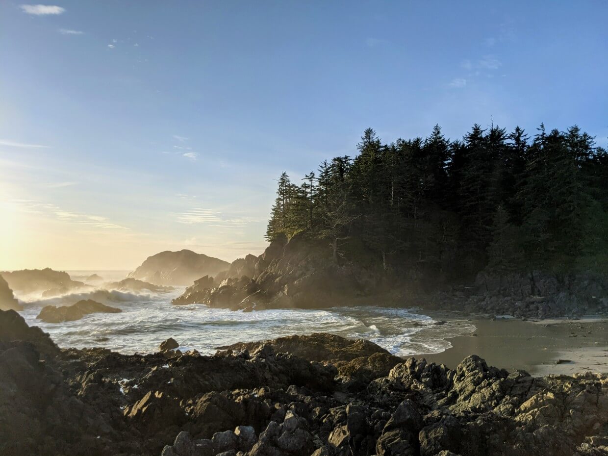
A spectacular stretch of golden sand awaited us, with rockpools to the northwest. Our evening campfire was accompanied by a stunning sunrise.


Day 2 – First Beach to Calvin Falls
Distance: 11km
Total Time: 6.5 hours
Moving time: 5 hours
Our first ‘real’ day of hiking on the Nootka Trail! We awoke to grey skies, drizzle and a very wet tent.
To leave First Beach, we first had to scale a short, steep rooty slope with the help of a rope. It initiated us into 1.5km of tricky terrain, alternating between overgrown forest and rocky pocket beach sections, with the occasional stretch of sand.
Beyond this, we were on the coast for the rest of the day. Pebble beaches scattered with pink toned seaweed were occasionally interrupted by creek crossings before giving way to long stretches of packed sand.
Finding a whale skeleton was a real highlight. Picked almost clean by scavengers, the bright white of the bones was quite a contrast to the greys of the surrounding rocks. JR found the mandible (jaw) bones in the forest nearby.

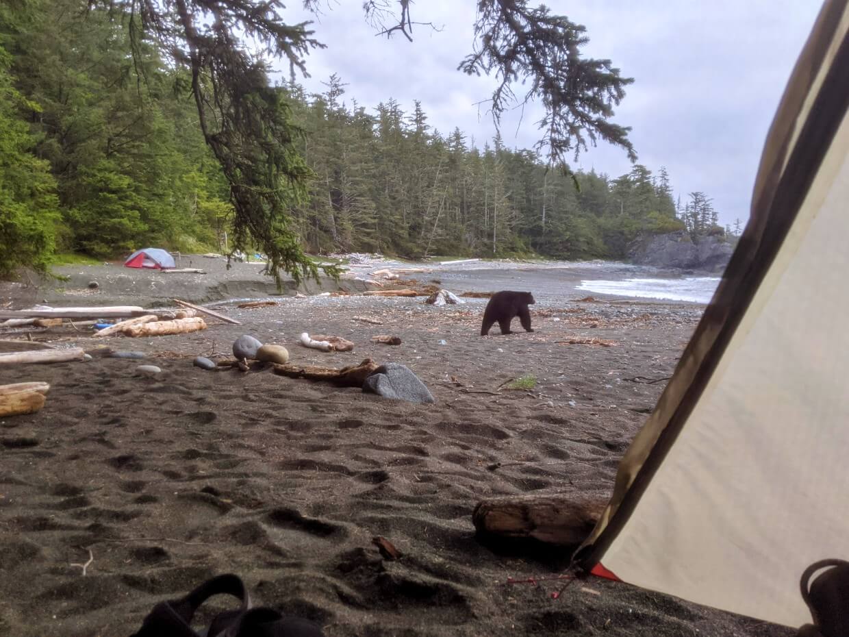
Just around the corner from Skuna Bay, we spotted a very large black bear on the beach ahead. As a group of four, we began moving towards it while making plenty of noise. Behind this one, however, was another bear with two cubs.
After a quick retreat and 45 minute break, we decided to try again, this time with John banging a washed up oil drum. That seemed to work – the family scattered into the forest and the big black bear climbed a tree. We passed cautiously…only to see another bear 10 minutes later!
With the rain continuing on and off all day, we were all pretty wet by the time we reached Calvin Falls.
The situation improved greatly after JR ventured into the woods and found an old surfer’s cabin. The shelter was much appreciated and we had a somewhat dry night.


Day 3 – Calvin Falls to Beano Creek
Distance: 10.7km
Total Time: 5 hours
Moving time: 6 hours
Relieved to wake up to overcast but dry weather, we walked away from Calvin Falls with our spirits fairly high. As a bonus, our entire hiking day would be on the beach!
The packed sand around Calvin Falls and following rock shelves offered great hiking conditions, though we were slowed down by creek crossings. We then headed into a stretch of small and medium sized boulders, some quite wet and slippery.
Thanks to the tide, we could walk around some of these boulders but not all. I’m not the best at rock hopping so found this stretch a bit slow. I was somewhat thankful to return to the pink toned seaweed and pebble beaches!

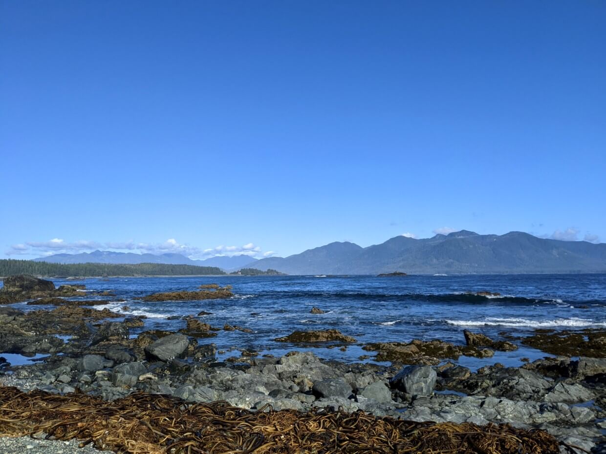
We stopped for lunch at Bajo Point, where we could hear seals barking on the nearby rock reef. The forest behind Bajo Point features a clearing, the location of the ancient First Nation village of Aaas.
After Bajo Point, the Nootka Trail reveals spectacular views of Vancouver Island and the path ahead. We also saw yet more bears.
The final challenge of the day was two kilometres of pea gravel as well as a couple more creek crossings. Causing your feet to sink with every step, pea gravel is pretty draining to walk on.
We were able to enjoy a lovely long evening at Beano Creek, topped off with a bioluminescence show from our tent! The ocean waves lit up blue and green as they hit the shore.


Day 4 – Beano Creek to Sunrise Beach
Distance: 8.8km
Total Time: 9 hours
Moving time: 7.25 hours
Though we only had a fairly short distance to hike, we knew this day would be a long one.
We didn’t know quite how long though, with online reports ranging between 9-12 hours for this stretch. With such limited daylight in mid September, we got up 5.30am (thankfully with clear skies!)
This section is time consuming as it alternates between forest and beach all day. It also involves some short scrambles (with rope assistance) and a muddy bog area. Attention is required for navigation as well as the physical aspects of these obstacles.
Our day started with a crossing of Beano Creek, which was running high and fast. We met a local resident (with a carved staff that made them look a bit like a sage) on the other side and continued below the cliffs to our first rope climb of the day.
The following forest section was beautiful but tough, with fallen trees, mud and huge root systems to traverse. I couldn’t believe the size of some of the old growth trees alongside the trail.

We then weaved in and out of pocket beaches, featuring a mix of rock shelves, packed sand, pebbles, cliffs, driftwood and caves. Due to the amount of recent rain, we needed to take off our hiking boots to cross multiple small creeks.
At kilometre 27, we stopped for a well earned lunch break. Our next break was at a cliff-top viewpoint at kilometre 29, just around the corner from an unusual rocky tidal inlet. Maquinna Point was a worthy (200m) detour, after which the trail was lined by high salal.
These overgrown bushes somehow managed to push out the safety catch on my bear spray, allowing the peppery vapour to discharge on JR as we scrambled down another headland. After washing and changing, he was able to continue, though with very sore sinuses.
A very wet section of shoreline bog provided some momentary navigational issues before the last few climbs and the final beach section. We were so happy to reach Sunrise Beach before 5pm!


Day 5 – Sunrise Beach to Yuquot
Distance: 3.5km
Total Time: 2.25 hours
Moving time: 2 hours
With the majority of the Nootka Trail behind us, our last hiking day was a short one (and almost entirely on the beach!) The highlight of the morning was a black bear casually strolling past our tents at 7.50am.
The tides were on our side as we approached the notorious Tsa’tsil Lagoon. Some hikers claim to have carried their backpacks over their heads to cross. Luckily for us, the dual channels were barely ankle deep (low tide).

The red roof of the church in Yuquot continued to loom larger as we hiked along the pebble beach. The experience seemed to be ending much quicker than I would have liked, though the relentless pebbles did slow us down a little.
In Yuquot, we were met by the Welcome/Watchman figure. We had finished the Nootka Trail!
Our seaplane wasn’t due for another three hours, so we decided to head to the lighthouse on nearby San Rafael Island.
At the time of our visit, Doug and Donna were the friendly caretakers of Nootka Light Station. After a long chat and a tour, we returned to Yuquot to check out the transformed church. Doug and Donna have since moved to the Pulteney Point Lighthouse on Sointula (Malcolm Island).
Regardless of who is stationed there, visitors are usually welcome at the lighthouse between 9am to 7pm each day.
The nave of Yuquot’s church now features colourful house posts (totems) and an impressive thunderbird statue, all replicas of originals that once stood in Yuquot bighouses in the 1920s.

Exhibits tell the story of the Mowachaht/Muchalaht, Yuquot and the village’s role in the creation of British Columbia as we know it today.
On the way out, we met Darryll (one of the two Yuquot residents at the time) and paid our trail fees.
Our seaplane arrived just as we finished eating a very late lunch on the beach. This time, we had not one, but two pilots.
As part of ‘training,’ we landed directly on the Gold River before taxiing back to the Air Nootka office. A very exciting way to finish an excellent coastal hiking adventure!

Nootka Trail Hiking Guide
This section features a complete guide to the Nootka Trail. It includes trailhead details, transportation logistics, camping areas, safety considerations and more.
The text ahead includes some affiliate links. If you make a purchase via one of these links, I may receive a percentage of the sale at no extra cost to you.

Location
The Nootka Trail is located on the western edge of Nootka Island, situated just off the northwestern coast of Vancouver Island, British Columbia.
The passage of water between Vancouver Island and Nootka Island is called Nootka Sound.
Access to Nootka Island is by boat and seaplane only. Most people heading to Nootka Island will travel there via Gold River or Tahsis, which are small communities on the west coast of Vancouver Island.
Vancouver Island can be reached by plane or vehicle ferry from Vancouver. The latter allows foot passengers. It’s also possible to fly to Vancouver Island from other destinations in Canada or the USA.
There is no scheduled bus service to Gold River or Tahsis. The nearest ferry terminal (to access mainland BC) is in Nanaimo, a three hour drive from Gold River. Continue another 90 minutes on a gravel road to reach Tahsis.

Nootka Trail length
There is some discrepancy about the exact length of the Nootka Trail. Some sources say 35km, others 36km and 37km.
Either way, there’s not a huge amount of difference. For the purpose of this post, I’ve used the 35km figure. All kilometer distances mentioned align with this.
John Baldwin’s Nootka Island map measures the trail as 35km from Starfish Lagoon to Yuquot. If you decide to start at Tongue Point, add 5.5km to the total.
Just over 80% of the Nootka Trail is on the beach, with the rest in the forest. This is a high ratio for a coastal trail. The West Coast Trail, for example, has much longer forest sections.

Difficulty
I would class the Nootka Trail as a moderately challenging trail overall.
There are, however, some aspects to the hike that push it towards a hard rating – river crossings, obstacle-course forest sections, tidal considerations, headland scrambling (short rope climbs), small boulders.
The most difficult rope climb is located at kilometre 23.9km. There’s a choice of two ropes – we used the left as it seemed more solid though still slippery.
I also think that the remote location has to be taken into consideration. The Nootka Trail is a long way from anything and an emergency evacuation would take considerable time.
There are not many ‘escape routes’ for hikers who may just want to leave early (one option would be to charter a flight from BC Air from Calvin Falls).
It is notable that we did not see a single other hiker during our September trip.
Weather is another factor to keep in mind. With most of the Nootka Trail being on the coast, hikers have a lot of exposure to weather.
In mid September, surfaces were slippery and creeks were higher due to recent rain. In a storm situation, hiking the trail could be quite dangerous.

First time backpackers
For all of the above reasons, I would not recommend the Nootka Trail to novice or first time backpackers.
If you have never been on a multi-day trip before, I would suggest building up to the Nootka Trail with some overnight hikes in provincial or national parks first. Some experience with coastal hiking would be preferable.
Comparison to the West Coast Trail
Just a few months before heading to Nootka Island, we hiked the West Coast Trail on Vancouver Island. Comparing the physical difficulty overall, I think the Nootka Trail is easier.
The southern half of the West Coast Trail features long forest sections with many obstacles (fallen trees, mud etc.) The Nootka Trail has similar forest stretches but they are a lot shorter overall.
I do think, however, that the Nootka Trail does present some unique challenges not seen on the West Coast Trail.
Examples would be the headland scrambles and the mandatory creek crossings. It is not necessary to cross major creeks on the WCT if the cable cars are operating.
The Nootka Trail also requires hikers to be more self reliant, due to the lack of facilities and more remote setting.

When to hike the Nootka Trail
The main Nootka Trail hiking season is from May to September.
October to April is not recommended due to lack of daylight, risk of storms, non-stop rain, big surf and fast creeks
July and August are definitely the most popular months to explore the trail, being the driest and warmest months
Keep in mind, however, that it can still get hot on Nootka Island’s beaches in July and August – coastal breezes can only do so much. Water can also be harder to find in the summer.
May, June and September can also offer pleasant hiking conditions. The weather will likely be more variable, however, with rain likely.
Nootka Island received around a meter of rain the week before our hike in mid September. I wouldn’t have wanted to be on the trail during that deluge!
Though we escaped the worst of it, we still felt the impact – we had to cross more creeks, the rivers were running higher, the forest sections were very wet, slippery and muddy.

Trailheads
The Nootka Trail has three trailheads:
- Yuquot – southern end
- Starfish Lagoon – northern end
- Tongue Point – northern end

Starfish (Louie) Lagoon
Starfish Lagoon is a wilderness trailhead, with zero facilities.
From the small rocky beach, hikers need to climb over a large tree trunk to access the forest trail to First Beach. Allow one hour for the 1km hike from Starfish Lagoon to First Beach.

Tongue Point
Tongue Point is also a wilderness trailhead, with zero facilities. The 5.5km hike to First Beach features mud flats and forest, as well as a surge channel that is passable at tides below 1.6m only.
Starting the Nootka Trail at Tongue Point offers the chance to see the shipwrecked remains of Greek freighter Treis Lerarchi.
Starfish Lagoon hikers can spot the shipwreck from the plane or day hike from First Beach to see it.
Yuquot
Yuquot is a Mowachaht/Muchalaht village, with a small collection of houses, church/cultural centre, campground and boat dock.
The manned Nootka Lighthouse is situated on nearby San Rafael Island, accessible via a footbridge.

Accessing the Nootka Trail
The vast majority of Nootka Trail hikers start at either Starfish Lagoon or Tongue Point and then travel south along the coastline to Yuquot. I would highly recommend organising your transportation in advance.
Starfish Lagoon
Starfish (Louie) Lagoon is primarily used as a seaplane drop-off point.
Air Nootka offers private charters from Gold River, a small community on the west coast of Vancouver Island. Accessible by paved road, the drive from Campbell River takes around 1 hour and 30 minutes (100km).
- Hikers need to check in at the Air Nootka office at least 45 minutes before departure
- All baggage is weighed in the office before being taken down to the dock
- Bear spray, bear bangers and fuel need to be put in a separate (provided) dry bag as they are carried in the float compartment of the aircraft – it’s a good idea to have these items separate from the rest of your items in advance
- Wear sandals and shorts for the flight – the landing is a wet one so you’ll be stepping out from the seaplane float right into the lagoon. The water is usually shin to knee deep
- Tie hiking shoes together so they are easier to unload from the plane at Starfish Lagoon
- Make sure that everything on the outside of your bag is securely fastened
The flight from Gold River takes around 40 minutes and follows the Nootka Trail route the entire way, so you can see what lies ahead. Be sure to watch for whales – JR spotted two humpbacks.
After arriving, we formed a line (with one person on the floats, three in the water) to pass the backpacks and other items from the plane to the beach. Before leaving, the pilot asked us to push the seaplane away from shore.

Tongue Point
Tongue Point is a drop-off point for water taxis. It’s a good alternative to the seaplane flight to Starfish Lagoon, especially when fog or other weather conditions prevent seaplanes flying.
Hikers starting at Tongue Point are able to see the shipwrecked remains of Greek freighter Treis Lerarchi during the water taxi journey and then also on foot on the way to First Beach.
Shorebird Expeditions offers private water taxi charters from Tahsis, a coastal community west of Gold River. It is a three hour drive from Campbell River to Tahsis (150km), with the portion between Gold River and Tahsis (64km) on an unpaved, gravel road.
There is no dock at Tongue Point. The landing are may be wet and slippery so it is advisable to wear sandals and shorts.
Calvin Falls
While Calvin Falls isn’t one of the main trailheads of the Nootka Trail, it is possible to be dropped off here by plane. Hikers then have the option to continue on to Yuquot (23km) or ‘backtrack’ to First Beach (12km).
BC Air flights land directly on the sand beach at Calvin Falls. Lower tide is required but no shoe removal needed.
Private charters with BC Air are available from a number of different departure points, with the cheapest option being Campbell River.
The flight loading process is very simple and not much extra time is needed. Plan to arrive 20-30 minutes before the flight. Parking is free.
Yuquot
At Yuquot, hikers have three main options (with another in the works) for onward transportation:
- Water taxi to Tahsis with Shorebird Expeditions
- MV Uchuck III boat to Gold River with Get West Adventure Cruises
- Seaplane flight to Gold River with Air Nootka
- Small plane flight to Campbell River with BC Air from airstrip near Yuquot – potential future fourth option
The MV Uchuck III is a 41m (136 foot) maritime freighter, originally built as a WWII minesweeper. It ships supplies and cargo to and from remote villages, fish farms, logging camps and resorts in the Nootka Sound area.
The vessel also offers regular sightseeing cruises and features an indoor lounge area and café (think sandwiches and soup).
The Uchuck picks up hikers at Yuquot on Wednesdays and Saturdays only. Check the Uchuck website for more details.

Parking
Gold River: Free parking is available for Nootka Trail hikers at the Muchalaht Marina in Gold River (part of trail fee). There is parallel parking on Mill Road, just up the street from the Air Nootka office. There is a drop-off area next to the office with space for two or three vehicles. Park here and check-in at the office before moving your vehicle further up the road.
Tahsis: Water taxi passengers should park in the grassy area across the road from the public boat launch. The fee is $25/week (cash or cheque only). Additional parking may be available at the Westview Marina and Tahsis Recreation Centre.
Campbell River: BC Air operate from Campbell River Airport. Free parking is available outside the BC Air building for customers (just south of the main terminal).

Nootka Trail cost and fees
While there is no reservation required to hike the Nootka Trail, there is a trail fee and significant transportation costs.
Trail fees
The Nootka Trail has a $75/per adult fee, made payable to the Mowachaht/Muchalaht First Nation.
Youth and senior passes are $25. Seniors are $50.
These fees can be paid:
- Online
- In person to the Williams family in Yuquot (cash only)
- At the Muchalaht Marina office in Gold River
Transportation fees
In addition to this fee, it is necessary to pay for transportation to and from the trailheads. This is the main expense of hiking the Nootka Trail.
The cost varies with the type of transportation, destination and amount of people in your hiking group.
Transportation fees (subject to change, all prices one way)
Air Nootka
Gold River to Starfish (Louie) Lagoon – $992.25 for groups of three or less, $1323 for groups of six or less
Yuquot to Gold River – $498.75 for groups of three or less, $682.50 for groups of six or less
Shorebird Expeditions
Tahsis to Tongue Point – $550 per trip (10 people maximum), $25 per person surcharge for groups of five or more
Yuquot to Tahsis – $450 per trip (10 people maximum), $20 per person surcharge for groups of five or more
BC Air
Campbell River to Calvin Falls – $653 for groups of three or less, $944 for groups of four or five
Get West Adventure Cruises (Uchuck)
Yuquot to Gold River – $106/adult, $76/child

Nootka Trail camping areas
As a wilderness path outside the provincial park or national park system, the Nootka Trail does not have any official campgrounds.
There are, however, established camping areas with flat areas for tents, driftwood for seating and nearby water sources.
No other facilities are available at these camping areas. For that reason, following Leave No Trace principles to reduce impact is very important.
This includes storing food and smelly items when not in use, cooking away from tent areas, cleaning up after meals, keeping fires small and disposing of waste properly.

In 2022, some green throne-style outhouses were added to popular camping areas.
By early September, thrones were present in the forest behind First Beach, Calvin Falls (south side) and Beano Creek (north side). Buoys indicate the outhouse trails.
When choosing a spot for your tent on the beach, be careful to locate the high tide line first – look for a line of debris, seaweed or driftwood along the shore.
Campfires are allowed when bans are not in place – check on the BC government website before heading out.


First Beach (Third Beach)
Location: 1km from Starfish Lagoon (34km from Yuquot)
Water access: Creek
Tenting area: Sand beach and some spots just inside forest
Facilities: A green throne toilet was added in summer 2022
This long stretch of golden sand is also known as Third Beach. It’s the first Nootka Trail camping area you’ll reach after being dropped off at Starfish Lagoon or Tongue Point.
The entrance to First Beach is next to a creek, also the water source from this camping area. From here, follow the right hand shoreline to find the most established camp spots. Tidepools mark the end of the beach.
I really loved camping at First Beach – I enjoyed having so much space to explore. Even if half a dozen groups were camping here, I don’t think it would feel too busy.


Skuna Bay
Location: 7.5km (27.5km from Yuquot)
Water access: Nearby creek
Tenting area: Driftwood lined pebble beach
This campground is located just around the corner from Skuna Bay, a broad inlet. At high tide, the beach is quite narrow. On our visit, there was also a lot of seaweed here.
John Baldwin suggests that this camping area is very close to the outlet of the creek. We didn’t get a good look as we were carefully passing a number of black bears at the time.
Another 500m or so from the camp location (the one marked on the official map), we found another suitable camping spot with lots of driftwood furniture and some shelter from overhanging trees. Obviously, this would have a longer walk to the creek.
I’m not sure which is the most used location but I have marked both on our Nootka Trail Google Map.
Either way, Skuna Bay isn’t a super popular place to camp. Hikers may stop here after an early start from Starfish Lagoon or if high tides prevent going further. Calvin Falls and First Beach are much nicer to camp at, in my opinion.


Calvin Falls
Location: 12km (23km from Yuquot)
Water access: Tidal creek
Tenting area: Sandy beach and sheltered forest
Facilities: A green throne toilet was added in summer 2022 (south side)
Camping at Falls is a highlight for many Nootka Trail hikers. The broad sandy beach is divided into two by a beautiful cascading waterfall.
Swimming is possible in the tidal creek below the falls, a great reward after a hot day of hiking. According to a friend, there is a way to climb up to the side of the waterfall (with a rope) and soak in potholes at the top.
The beach offers plenty of space for camping on both sides of Calvin Falls. We stayed on the northern side, where we discovered a sheltered forest area complete with an open sided cabin.
The long sandy beach here is a popular destination for surfers (who charter a flight in) as well as seaplane flight schools.


Beano Creek
Location: 22.7km (12.3km from Yuquot)
Water access: Fast flowing creek
Tenting area: Pebble beach and sheltered forest
Facilities: A green throne toilet was added in summer 2022 (north side)
Beano Creek changes in appearance from year to year, as the storms unsettle and rearrange the piles of beach pebbles.
There is lots of space for camping though, with plenty of spots along the north side of the creek. There is a large, sheltered area just inside the bordering forest too.
This is the first camping area that offers views of Vancouver Island. It does lose some wilderness feel, however, with cabins being present on the other (south) side of the creek.
We were lucky to see bioluminescence at Beano Creek, with the incoming waves being lit up with blue and green colours.


Sunrise Beach
Location: 31.5km (3.5km from Yuquot)
Water access: Tea coloured creek
Tenting area: Sandy beach
Since the creek running through this camping area doesn’t have a formal name, it was coined ‘Sunrise Beach’ by MBGuiding. I’m going to refer to it as the same as it is the perfect description.
Sunrise Beach is a very welcome sight after hiking all the way from Beano Creek. The medium sized beach is quite spacious, with a couple of different ‘cooking’ areas complete with driftwood furniture.
A small pond sits a few hundred metres back from the beach, making this camping area a popular through route for wildlife.
The views from Sunrise Beach are beautiful, with the Vancouver Island mainland visible across the Sound. It’s also possible to see the red roof of the church in Yuquot, signaling the end of the trail.


Sea Stack Beach
Location: 33.5km (1.5km from Yuquot)
Water access: Small creek
Tenting area: Sand/small pebble beach
Sea Stack Beach is located right on the border of the Yuquot Indian Reserve #1. The church in Yuquot is quite visible from here. It’s a good place to stay if you have an early departure from Yuquot or want extra time to explore the village.
This camping area is an ideal alternative to Sunrise Beach if the timing of the low tide at Tsa’tsil Lagoon proves tricky to work around.
Like Sunrise Beach, Sea Stack Beach doesn’t have a named creek. Its nickname originates from the surrounding rock formations.
A small creek runs pretty reliably through this camping area, though it sometimes disappears into the sand before reaching the ocean.


Yuquot
Location: Kilometre 35
Water access: Unknown
Tenting area: Grassy meadow
The village of Yuquot (also known as Friendly Cove) is the Nootka Trail’s southern trailhead. Most hikers finish here and travel onwards to Tahsis and Gold River by boat or seaplane.
The Nootka Trail fee includes camping in Yuquot, on a grassy area just behind the main beach. There are composting outhouses, picnic tables and fire pits.
I believe that a shelter and cabins have been available in previous years but I’m not sure of the current status.
Located on a peninsula, Yuquot offers some fantastic views of Nootka Sound and Vancouver Island.
Campers can go for a swim in nearby Jewitt Lake, hang out on the beach, visit the church/cultural centre and meet the friendly lighthouse keepers (Doug and Donna).


Other camping options
There is no requirement to camp at any of the above camping areas while hiking the Nootka Trail – these are just the most popular spots.
Two alternative places to camp are found on small pocket beaches between Beano Creek and Maquinna Point:
- The first (around kilometre 27) is on the smaller size with a very seasonal waterfall
- The second (around kilometre 27.6km) also has a seasonal water source. The beach is larger with some space in the dark forest behind
Both of these camping areas are marked on John Baldwin’s Nootka Trail map.

How to navigate on the Nootka Trail
The Nootka Trail is an established route and sees around 500 hikers each year. It is not, however, located in a provincial or national park and does not receive regular or extensive maintenance. Signage is pretty limited.
While it is not overly difficult to navigate the Nootka Trail, some attention is needed.
The coastal sections are, for the most part, fairly straightforward – after all, the ocean will always be on the same side!
It is important, however, to know when it is necessary to head inland into the forest or wait for favourable tides (see tides section below).

This is especially true between Beano Creek and Yuquot, when the trail weaves in and out of the forest more than a dozen times. Keep an eye out for colourful buoys in the trees and ropes leading up and down headlands.
The forest sections feature sporadic orange metal blazes (markers) attached to trees. These definitely helped us out a few times, as it was not always easy to see through the overgrown salal or huge old growth trees.
One of the trickiest areas we found to navigate was the inland bog area located around kilometre 30.5.
I’d highly recommend John Baldwin’s Nootka Island map for on-trail navigation. It notes campground locations, viewpoints and side trails as well as tidal problems.

Nootka Trail tides
With most of the Nootka Trail being on the coast, hikers should have an understanding of tidal systems.
The most significant tidal problems are located at:
- Skuna Bay
- Calvin Creek
- Beano Creek
- East of Beano Creek
- Tsa’tsil Lagoon
Depending on the weather (high winds, flooding), other sections of the Nootka Trail may be problematic to hike at high tide.

Tide basics
Ocean tides are influenced by the gravitational pull of the moon on the Earth. The time and height of tides varies between geographic locations.
On Vancouver Island’s west coast, there are two high and two low tides every 24 hours or so. The timing of these high and low tides changes every day.
Keep in mind that weather can affect high and low tides. High pressure systems (fair weather) can cause lower tides, while lower pressure systems (unsettled weather) can cause higher tides.
Wind can also influence the movement of water. During storms, water levels usually rise.

Tide tables
Tide tables display predicted tide heights throughout the day in one particular coastal area.
The best tide tables to use for the Nootka Trail are those produced for the Saavedra Islands.
I would recommend downloading and printing an hourly Saavendra Islands tide table in advance of your trip (see below for example).

Water crossings
Please see the next section for more information about river crossings on the Nootka Trail.
Impassable headlands and cliffs
Two sections of the Nootka Trail feature impassable headlands or cliffs:
- Skuna Bay
- East of Beano Creek
Both of these stretches have two areas which require attention. At Skuna Bay, the high tide rushes up to steep sandstone shelves.
Hikers have no option but to wait until the tide recedes. Skuna Bay is wide enough so you can see the shelves when approaching (around kilometre 8).
Just beyond kilometre 25, east of Beano Creek, there are two short sections of beach that can be cut off by the high tide. There is an inland bypass trail in each case. Look for colourful buoys and orange blazes.
All four of these high tide problems are marked on John Baldwin’s Nootka Trail map.

River and creek crossings
The Nootka Trail is a wilderness path and there are no formal bridges or cable cars to help hikers cross rivers and creeks.
There are three significant river and creek crossings on the Nootka Trail, as well as multiple smaller crossings.
Seasonal and minor creeks
After heavy rain, the number of seasonal creeks on the Nootka Trail increases.
I would guess that we crossed more than a dozen creeks during our mid September hike. To avoid wet feet, I had to swap my hiking boots for sandals for most of them.
In drier months, it may be possible to rock hop smaller creeks and not have to change shoes. Driftwood can sometimes form informal bridges (see below).

Major river and creek crossings
The most significant water crossings on the Nootka Trail are:
- Calvin Creek
- Beano Creek
- Tsa’tsil Lagoon
There is no official determination of which tide height allows these rivers and creeks to be safely crossed (unlike the West Coast Trail, for example).
The tide height is not the only factor that impacts safe crossing potential. Recent weather, such as heavy rain, can cause water levels to be higher.

Winter storms rearrange the terrain underfoot, so the channel may be deeper or shallower from year to year. Tsa’tsil Lagoon has a reputation for strong currents and deceptively deep depths.
We crossed all three of these major tidal problems within an hour or two of low tide. Our experience varied:
- Calvin Creek featured a wide, ankle-deep outflow. It was followed by very shallow channels of water across the lower (closer to the ocean) half of the beach
- Beano Creek was difficult, with strong currents and high water levels. JR and I linked arms and crossed together and even then, I found it hard to move against the rushing water. Luckily, the crossing was short
- Tsa’tsil Lagoon consisted of two shallow channels of water, just above ankle height
Before heading out to the Nootka Trail, I’d suggest learning more about how to cross rivers and creeks safely.

Which way to hike the Nootka Trail
Technically, the Nootka Trail can be hiked in either direction.
The majority of Nootka Trail hikers, however, travel in a north to south direction from Tongue Point or Starfish Lagoon to Yuquot. This is mainly due to transportation logistics.
Air Nootka, for example, can pick up at Starfish Lagoon but state that more than one pick up may be needed due to the short ‘runway.’ In that situation, there would be an additional charter fee.

Nootka Trail itinerary suggestions
For some trip planning inspiration, here are some example Nootka Trail itineraries.
When considering itineraries, keep in the following in mind:
- Available transportation
- Transportation arrival/departure times
- Weather/season
- Tide times
- Fitness/ability of group
Please note that the suggested hiking time each day is moving time only. It does not account for breaks. The lower number is for fast hikers. The upper number is for slower hikers.
5 day Nootka Trail itinerary
In case you didn’t read our trip report, our itinerary was:
- Day 1 – Starfish Lagoon to First Beach (1km, 45 minutes to 1.5 hour)
- Day 2 – First Beach to Calvin Falls (11km, 5.5 to 7.5 hours)
- Day 3 – Calvin Falls to Beano Creek (10.7km, 4 to 6 hours)
- Day 4 – Beano Creek to Sunrise Beach (8.8km, 7 to 9 hours)
- Day 5 – Sunrise Beach to Yuquot (3.5km, 1.5 to 3 hours)
This five day Nootka Trail itinerary seems to be quite popular. The first, very short day, offers a chance to ease into the experience. The next two days are fairly balanced.
The fourth day is the hardest and longest but is manageable with an early start and regular breaks.
The final day is short, usually allowing for plenty of time to explore Yuquot (meet the lighthouse keepers, visit the church/cultural centre, relax on the beach).

6 day Nootka Trail itinerary (summer)
In mid-summer (when water is scarce), a better 6 day itinerary would be:
- Day 1 – Starfish Lagoon to First Beach (1km, 45 minutes to 1.5 hour)
- Day 2 – First Beach to Calvin Falls (11km, 5.5 to 7.5 hours)
- Day 3 – Calvin Falls (rest day)
- Day 4 – Calvin Falls to Beano Creek (10.7km, 4 to 6 hours)
- Day 4 – Beano Creek to Sunrise Beach (8.8km, 7 to 9 hours)
- Day 5 – Sunrise Beach to Yuquot (3.5km, 1.5 to 3 hours)
An extra night at Calvin Falls is welcomed by many Nootka Trail hikers. It’s a beautiful stop and it would be wonderful to cool off in the waterfall on a hot day.
6 day Nootka Trail itinerary (shoulder seasons)
If we had an extra day, I would have spent a night at one of the beaches between Beano Creek and Sunrise Beach. The itinerary would have looked like this:
- Day 1 – Starfish Lagoon to First Beach (1km, 45 minutes to 1.5 hour)
- Day 2 – First Beach to Calvin Falls (11km, 5.5 to 7.5 hours)
- Day 3 – Calvin Falls to Beano Creek (10.7km, 4 to 6 hours)
- Day 4 – Beano Creek to Unnamed beach (4.9km, 4 to 5 hours)
- Day 5 – Unnamed beach to Sunrise Beach (3.9km, 3 to 4 hours)
- Day 5 – Sunrise Beach to Yuquot (3.5km, 1.5 to 3 hours)
This itinerary would have allowed us the extra time to check out the sea caves around kilometer 31.
Access to water can be a problem in the area between Beano Creek and Sunrise Beach so I wouldn’t recommend this itinerary in July or August.

7 day Nootka Trail itinerary
One of the best aspects of the Nootka Trail is the opportunity to take as long as you like. Indeed, some Nootka hikers spend a week or more on the trail, camping in the same area for multiple nights.
With the transportation costs being the biggest expense of the trip, it’s not a bad idea to stay longer and get additional value!
If I was to spend a week on the Nootka Trail, this would be my itinerary:
- Day 1 – Starfish Lagoon to First Beach (1km, 45 minutes to 1.5 hour)
- Day 2 – Day hike to Treis Lerarchi shipwreck, overnight at First Beach (11km, 5 to 7 hours)
- Day 3 – First Beach to Calvin Falls (11km, 5.5 to 7.5 hours)
- Day 4 – Calvin Falls (rest day)
- Day 5 – Calvin Falls to Beano Creek (10.7km, 4 to 6 hours)
- Day 6 – Beano Creek to Sunrise Beach (8.8km, 7 to 9 hours)
- Day 7 – Sunrise Beach to Yuquot (3.5km, 1.5 to 3 hours)
4 day Nootka Trail itinerary
Don’t have a lot of time? Consider this shortened Nootka Trail itinerary:
- Day 1 – Starfish Lagoon to Calvin Falls (12km, 6 to 8 hours)
- Day 2 – Calvin Falls to Beano Creek (10.7km, 4 to 6 hours)
- Day 3 – Beano Creek to Sunrise Beach (8.8km, 7 to 9 hours)
- Day 4 – Sunrise Beach to Yuquot (3.5km, 1.5 to 3 hours)
Depending on the tides, you may be able to arrive at Starfish Lagoon relatively early in the day. In that situation, some hiking groups decide to continue onto Skuna Bay or Calvin Falls.
If you find this itinerary to be too ambitious, here’s an alternative:
- Day 1 – Arrive at Calvin Falls (optional day hike to the north)
- Day 2 – Calvin Falls to Beano Creek (10.7km, 4 to 6 hours)
- Day 3 – Beano Creek to Sunrise Beach (8.8km, 7 to 9 hours)
- Day 4 – Sunrise Beach to Yuquot (3.5km, 1.5 to 3 hours)
Start with a flight from Campbell River to Calvin Falls with BC Air. Spend the rest of your first day enjoying this beautiful waterfall and beach or day hike north along the trail.
On day two, continue with the standard Nootka Trail itinerary.
Please note that this itinerary would require two vehicles – one would need to be parked in Campbell River (for the outbound flight) and the other in Gold River (return seaplane flight or Uchuck).
Sunrise Beach vs Sea Stack Beach
The choice to stay at Sunrise Beach or Sea Stack Beach for the last night is usually determined by the low tide time at Tsa’tsil Lagoon and the energy levels of the group.
During our hike, continuing on to Sea Stack Beach wasn’t a consideration as we were limited with daylight and we were all ready to stop and rest at Sunrise Beach.
Alternatively, strong hikers may want to stay in Yuquot. Nootka Trail users are allowed to camp in the grassy area of the village.
Wildlife on the Nootka Trail
Nootka Island is home to a variety of animals, with black bears and wolves commonly seen. We personally saw as many as eight black bears and I’ll assume that there were many more beyond our eyeline!
Our only sighting of a wolf was from a distance, but we saw quite a collection of tracks along the trail. We were advised at Beano Creek and Yuquot that packs of wolves are seen relatively often.
With the Nootka Trail having such a high concentration of black bears and wolves, I would definitely not recommend bringing your dog. We were advised by Darryll in Yuquot that he regularly loses dogs to the wolf packs.
For all these reasons, I would say that bear spray is an absolute necessity when hiking the Nootka Trail. Our group carried one each. I also had an airhorn, which I did use.
Before heading to the Nootka Trail, I would be sure to brush up bear safety as well as wolf safety to reduce the risk of a negative encounter (and know what to do if you do see one!)
Some basics are:
- Make noise as you hike
- Keep a clean camp
- Cook and store food well away from tents
- Pack out everything you bring with you (even trash)
- Keep your distance from wildlife
- Always leave animals with an escape route
- Avoid animal carcasses
Whales can sometimes be spotted from the Nootka Trail. We were not lucky enough to see any on our hike but JR did spot a couple of humpbacks from the seaplane on our way in!

Safety information
The Nootka Trail is a remote hike in a wilderness area. Being self sufficient is essential. The main hazards of this trail are:
- Beach terrain. Rock shelves, seaweed, boulders and driftwood can be very slippery. Barnacles are sharp. Soft sand and pea gravel can be tiring to hike on. Some headlands require some scrambling (with a rope)
- Mud. There are some muddy and boggy forest sections, which are usually muddier in spring and fall
- Trees. The route passes through some incredible old growth forests. But this does mean that there are some pretty gnarly root and fallen tree obstacles, which are often exceptionally slippery after rain
- Tides. When hiking the Nootka Trail, you need to understand how to read a tide table and be prepared to hike according to it. More info here
- Creek and river crossings. There are three significant water crossings as well as numerous smaller crossings (especially after heavy rain). More info here

- Remote location. There is no phone signal or road access to the Nootka Trail. Due to the isolation, I would say that a satellite communication device is essential in case of emergency
- Wildlife. Black bears, wolves and cougars live on Nootka Island. The vast majority of hikers will not have any negative wildlife encounters but you should be proactive in reducing your risk. More info here
- Tsunamis. Though a very rare occurrence, hikers need to be aware of the possibility of a tsunami while on the Nootka Trail. Move to higher ground if you feel the ground shake or the ocean recede quickly
- Weather. Due to the high amount of beach walking involved in this hike, there is a lot of exposure to weather. This could include heavy rain, high winds or hot sun
- Water shortage. During the height of summer, fresh water can be scarce on the Nootka Trail. Advance planning is necessary for some sections. More info here

Finding water on the Nootka Trail
One of the biggest challenges of hiking the Nootka Trail in summer can be finding water.
The best water sources on the Nootka Trail are found at the ‘established’ campgrounds of First Beach, Skuna Bay, Calvin Falls, Beano Creek, Sunrise Beach and Sea Stack Beach. The most reliable water source besides these is Callicum Creek at 25.5km.
Seasonal water sources come and go throughout the season, appearing and disappearing after rain.
Lack of water between Beano Creek and Sunrise Beach pushes most people to hike this section in one long day, rather than camp somewhere along the route.
If you don’t usually carry much water with you on multi-day hikes, I would reconsider this if hiking the Nootka Trail from mid July to late August.
During our mid September hike, finding water on the Nootka Trail was definitely not an issue. Vancouver Island had received plenty of rain within the preceding week so waterfalls were cascading off the cliffs everywhere and formerly dry creeks were running fast.
Due to the isolation of the trail and unknown quality, I would recommend purifying water for drinking. Personally, I prefer to use a filter as it also removes larger particles in the water. We used MSR’s Trail Shot Filter on this hike.

Essential items to bring
Besides all of your camping gear, clothing and 10 Essentials, I’d recommend bringing the following items for your Nootka Trail adventure:
- Nootka Island map. There is limited signage on the Nootka Trail. We used John Baldwin’s Nootka Island map for planning and on-trail navigation. It is waterproof and tearproof, so relatively durable
- Hiking poles. I used a single hiking pole quite a lot on the Nootka Trail, especially when hiking beach sections. JR and I usually share a pair of Black Diamond’s Carbon Z poles (less than 300g)
- Sandals. With three or more water crossings required, a pair of water shoes is a must have for the Nootka Trail. It’s a bonus if your water shoes can double up as comfortable shoes to wear around camp (like my Teva Hurricane Drift sandals)
- Tide table. As mentioned in the tides section, a tide table is essential for hiking the Nootka Trail. We used the Saavedra Islands tide tables. We referred to it and our map each evening and morning

- Bear spray. With black bears, cougars and wolves all roaming Nootka Island, it’s a good idea to carry bear spray ‘just in case.’ Keep it in a convenient place, close enough to access quickly. I’d recommend using a holster like this
- Rope/cord and carabiner. There are no food storage facilities on the Nootka Trail. Hikers need to hang food and smelly items away from camp, 15m of rope/cord and a carabiner will help
- An axe. Campfires help make damp evenings feel a lot more comfortable!
- Satellite communication device. We were very happy to have our InReach for emergencies. In the event of a delay, we would have been able to re-arrange our seaplane flight with Air Nootka. We were also able to send daily messages with our location to family members
- Cash. It is possible to buy burgers, hot dogs, chili, chips, coffee, pop (and more) at the end of the trail in Yuquot. Ask for Sugar at the two story house across the open field. Open on request only. Sugar plans to accept cards in future but bring cash for now

If you’re a planner, consider purchasing these guidebooks in advance:
- Coastal Hikes: A Guide to West Coast Hiking in British Columbia and Washington State by Philip Stone
- Hiking the West Coast of Vancouver Island: An Updated and Comprehensive Trail Guide by Tim Leadem
You may also enjoy this illustrated Nootka Trail map published by the Federation of Mountain Clubs of BC (FMCBC). It was created to promote the conservation of west Nootka Island (not suited for navigation).

Where to stay before and after the Nootka Trail
With the Nootka Trail being so remote, most hikers spend at least one night in or close to Gold River or Tahsis before starting.
Here are my recommendations for accommodation and camping in Gold River, Strathcona Provincial Park and Campbell River.
Gold River
Gold River (pop 1200) is the nearest community to the Air Nootka office.
Gold River Chalet offers a variety of comfortable rooms, some with multiple double beds. Unfussy yet highly rated, this B&B is very close to the main commercial area of Gold River.
Ridgeview Motor Inn is the only motel in town. The property has recently changed hands and all rooms have been newly renovated.

Strathcona Provincial Park
Established in 1911, Strathcona is British Columbia’s oldest provincial park. Highway 28 travels through Strathcona between Campbell River and Gold River.
There are two vehicle accessible campgrounds in Strathcona Provincial Park – Buttle Lake and Ralph River. Both are set into beautiful Douglas Fir forests and have lake access.
- Buttle Lake (85 sites) is the most convenient option if you’re just passing through as the entrance is right off Highway 28
- Ralph River (75 sites) is located two thirds of the way down Buttle Lake, a 50km return drive
After our Nootka Trail hike, we stayed at Strathcona Park Lodge. Situated just outside the park boundary, the lodge is completely off grid and also operates as an outdoor education centre.


While we really liked our spacious room and balcony overlooking Upper Campbell Lake, we felt it was a little pricey. We were also surprised that shampoo and conditioner were not available without an extra fee (two items we really wanted after hiking the Nootka Trail!)
After checking in, we ate dinner at the on-site Whale Room restaurant. Made with locally sourced, in-season ingredients, the wholesome food is served buffet-style. It was definitely a lot healthier than the usual post-hike fare we normally go for!

Campbell River
As regular visitors to Vancouver Island, we find ourselves in Campbell River reasonably often.
Our favourite place to stay is the Above Tide Motel. While not fancy, the oceanside location is incredible and the prices very reasonable (even in summer).
Each room has a balcony, offering views of Discovery Passage and Quadra Island. The motel is walking distance to Discovery Pier.
Check out these other BC backpacking guides next:
The West Coast Trail
North Coast Trail

One half of the Canadian/British couple behind Off Track Travel, Gemma is happiest when hiking on the trail or planning the next big travel adventure. JR and Gemma are currently based in the beautiful Okanagan Valley, British Columbia, Canada. Consider buying us a coffee if you have find any of our guides helpful!
Thank you for the comprehensive and very informative write up on the Nootka Trail.
Appreciate you taking the time to tell me, thanks Linda. Have a great trip!
I have 1 opportunity for a backpacking trip in 2022 so thought I would jump onto your site and see what you’ve been up to since the West Coast Trail… Nootka Trail was on my shortlist and look where you guys have been! Awesome write up, gave me all the info I needed 🙂
So awesome Sophie! It’s great to hear from you. I’m so glad this post helped your planning. I’d love to know what you think of the Nootka Trail when you do it!
This is the best trail report I have come across in my research for this trek. We are heading out to Louie Bay on Monday morning and your writeup answered all of my last minute unanswered queries. Thanks for taking the time to cover all the bases. I feel far more prepared now!
Thank you so much for letting me know! Happy trails!
I’m delighted that you took the time to write such an all-encompassing account of your hike! Thank you for including pictures and all of the great tips. Happy hiking!
Thanks so much for the kind comments Meg! Have a great hike!
this is an excellent resource! thanks for putting this together 🙂
Thanks so much for letting me know that you found it helpful Pam 🙂 Happy trails