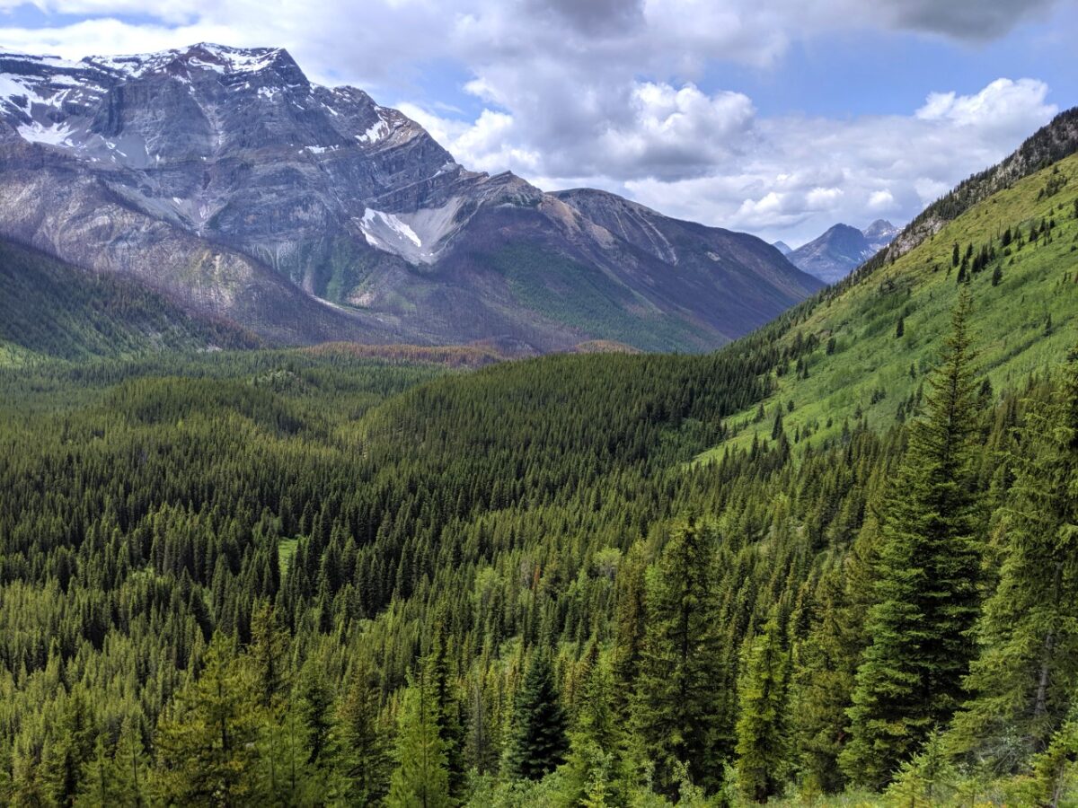
Mount Assiniboine Provincial Park plays host to some of the most glorious alpine scenery in the Canadian Rockies.
The pyramidal shaped peak of Mount Assiniboine itself is just the jewel in a crown of impressive peaks, studded with turquoise lakes and expansive alpine meadows.

With all this in mind, Mount Assiniboine Provincial Park is one of the most popular BC backpacking trip destinations. It’s also one of our favourite places in British Columbia!
This super detailed guide, written by a BC local, will help you start planning your own hiking trip to Mount Assiniboine Provincial Park in British Columbia, Canada. It includes all of the recent BC Parks fee updates.
Here’s what to expect:
This post includes some affiliate links – if you make a purchase via one of these, we may receive a small percentage of the sale.
We stayed at Sunshine Mountain Lodge during our most recent trip and received gondola passes courtesy of Banff Sunshine and Ski Big 3.

Backcountry necessities
- Always bring the 10 Essentials
- Know how to stay safe in the backcountry
- Remember to Leave No Trace to help keep the wilderness wild
- Understand how to avoid negative bear encounters
- Trying out backpacking for the first time? Read Backpacking 101
- Check out our packing guide with gear recommendations
- Sign up to our newsletter for a free backpacking checklist

Introducing Mount Assiniboine Provincial Park
Often called the ‘Matterhorn of the Canadian Rockies,’ Mount Assiniboine is as striking as it is beautiful. But this peak isn’t the only attraction of the area.
This alpine wonderland is a real playground for hikers, as well as being a UNESCO World Heritage site.
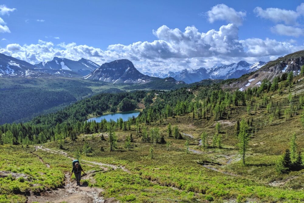
The best way to explore Mount Assiniboine Provincial Park is on a 4 to 6 day backpacking trip.

Though the distances may seem intimidating at first for some hikers (26km minimum one-way distance to reach the core area of the park), I am pretty sure no one has ever regretted making the effort.
Mount Assiniboine, pronounced ‘uh-si-nuh-boyn,’ is just one of those amazing one-of-a-kind places that is worth every step.
The park is located within the traditional territory of the Ktunaxa/Kootenai First Nations people. The Peigans, the Assiniboine and the Blackfoot also travelled this area.
Mount Assiniboine was named after the local Assiniboine people by G.M. Dawson, representing the Geological Survey of Canada. The word Assiniboine means ‘stone boiler,’ referring to the practice of using hot rocks to cook food.

Mount Assiniboine: Quick facts
Personally, I found planning for our first Mount Assiniboine trip a little confusing at first.
Unlike some other BC backpacking trips, the Mount Assiniboine area has a wide choice of campgrounds, trailheads and itineraries.
It probably doesn’t help that while Mount Assiniboine is located in a provincial park in BC, the most popular access routes are through Banff National Park in Alberta!
Here’s the lowdown:
- Mount Assiniboine Provincial Park is accessible only via foot, horse or helicopter (no vehicle access)
- Though located in British Columbia, the park is most easily accessed via Alberta
- The length of hike (in kilometres) is variable, depending on your chosen trailhead(s) and itinerary. Minimum 52km without a helicopter ride
- The core area of the park is the area around Magog Lake and sits at 2180m elevation
- 4 to 6 days is the ideal length of time for a backpacking trip
- The most used access trails to the core area of the park are moderately difficult
- The core area is usually snow-free from late July to early September
- Reservations are required for the two most popular campgrounds – Og Lake and Magog Lake ($25/per person/adult for camping, $6/nightly reservation fee)
- Mount Assiniboine campsite reservations are available on a three month rolling window
- Alternatively, there are huts ($150-$240/night) as well as cabins and lodge rooms at Magog Lake Lodge (reservations also required)
- Leashed dogs are allowed
- Hikers MUST be bear aware and should carry bear spray

Hiking to Mount Assiniboine: Our experience
We have personally visited Mount Assiniboine Provincial Park twice.
The first time was a dedicated trip, starting and finishing at the Sunshine Village trailhead. This was the best value option available to us at the time since we were using one vehicle only.
Our itinerary was:
- Day 1: Sunshine Village to Porcupine Campground (13km)
- Day 2: Porcupine campground to Magog Lake (14.5km)
- Day 3: Magog Lake campground
- Day 4: Magog Lake campground to Howard Douglas campground (21.5km)
- Day 5: Howard Douglas campground to Sunshine Village (6km)
Hiking in mid-July, we arrived at the top of the Sunshine gondola to discover 20cm of snow on the ground. Thankfully, this disappeared as we descended into the valley below Citadel Pass.

The rest of our backpacking trip remained cold however, with freezing temperatures overnight at Lake Magog and clouds obscuring the peak of Mount Assiniboine for the length of our stay.
We returned in late August another year, as part of a 11-day hike along the Great Divide Trail. Seeing the peak of Mount Assiniboine was still on my list and I was hoping this trip would be more successful!
This was our itinerary:
- Day 1 to 5: Paint Pots to Floe Lake Parking Lot (the Rockwall)
- Day 6 to 8: Floe Lake Parking Lot to Sunshine Village
- Day 9: Sunshine Village to Og Lake (20.9km)
- Day 10: Og Lake to Magog Lake (6.6km)
- Day 11: Magog Lake to Mount Shark Trailhead (27km)
While we didn’t have any snow this time, it did rain non-stop for over 12 hours while we were at Magog Lake! Temperatures were also around freezing.
While conditions were, again, challenging, we saw the summit of Mount Assiniboine twice on this trip – once at Og Lake and also on our very last morning, before hiking out to Mount Shark via Wonder Pass.

Mount Assiniboine Hiking Guide
In this section, I’ll break down the essential information for planning a Mount Assiniboine backpacking trip.
Location
Mount Assiniboine Provincial Park is located in British Columbia in the Canadian Rockies, sandwiched on two sides by Kootenay National Park and Banff National Park.
There is no road access to Mount Assiniboine Provincial Park – visitors must hike, ride (on horse) or fly in by helicopter.
Mount Assiniboine PP and the most popular access routes can be seen on Parks Canada’s Banff National Park backcountry map.

Trailheads
The majority of hikers travel reach the core area of Mount Assiniboine Provincial Park via maintained trails through Banff National Park.
The most used trailheads are located at Mount Shark (Bryant Creek) and Sunshine Village.
A far less used trailhead is located in Kootenay National Park – the Simpson River. The trail from Simpson River to the core area is 31.5km one way and travels through a fire-damaged landscape.
The Kootenay NP side of the trail is apparently well maintained, but the Mount Assiniboine side is not (expect blown down trees and potential difficulty to follow the trail).

Sunshine Village Trailhead
Sunshine Village is a ski resort in Banff National Park and the most northern trailhead for Mount Assiniboine Provincial Park.
Sunshine Village operates a daily gondola from late June to early September.
The 17 minute ride takes hikers from the base area parking lot to the upper village (2159m), where the Mount Assiniboine trail starts.
- The gondola runs 8am to 6pm
- Staff greet all visitors at the top of the gondola and can offer directions if needed
- One-way tickets are issued at the discretion of management, from Guest Services at the base or in the upper village
- It is possible to hike up the dirt road from the base area parking lot to the upper village, but there is an additional distance of 6km with 500m elevation gain
- Sunshine Village is an easy drive 18km from Banff (20 minutes) on paved roads
- There is a regularly scheduled free bus service from Banff to the Sunshine Village parking lot
With Sunshine Village being a full-service summer resort, it’s possible to finish your hike with a celebratory beer at the Mad Trappers Smokehouse in the village.
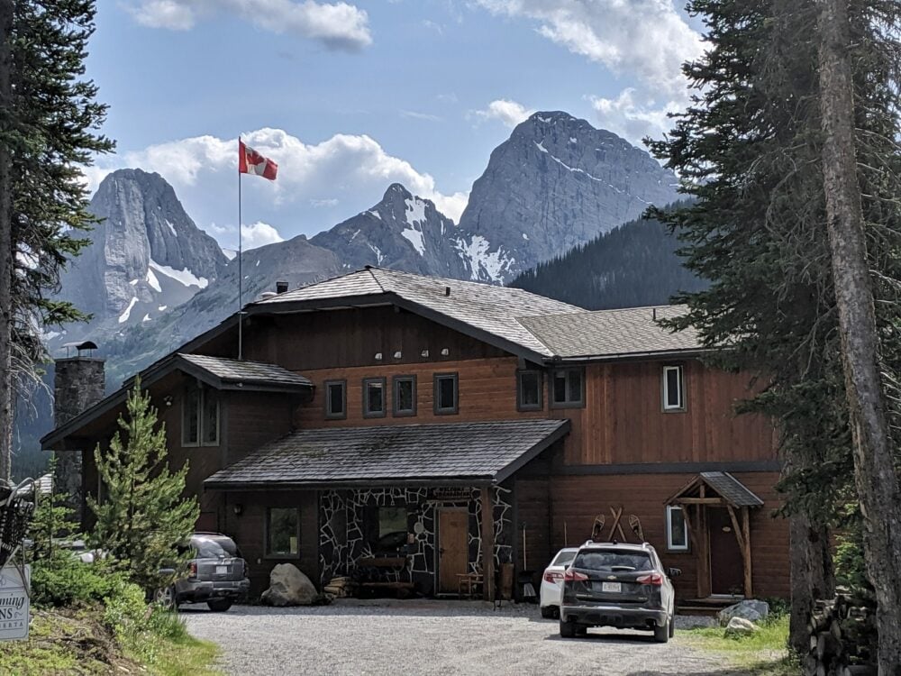
For the ultimate Mount Assiniboine experience, consider a night at the Sunshine Mountain Lodge before or after your hike.
Located at 2,400m, the lodge is host to beautiful alpine views, which you can enjoy from Banff’s largest hot tub.
Upscale dining is available at the Chimney Corner and Eagle’s Nest Canadian Bistro (upstairs). Reservations recommended.

Mount Shark Trailhead (aka Bryant Creek)
Mount Shark is a hiking and cross-country ski parking lot in Spray Valley Provincial Park, Alberta. It is located very close to Mount Engadine Lodge.
- The most direct route to Mount Shark is via Highway 742 from Canmore. It takes just over an hour. The road is mainly unpaved and bumpy in places. Take the turnoff to Mount Engadine Lodge and then continue following to the end of the road (7km) to find the parking lot
- From Calgary, it can be quicker to drive Highway 40 south and then approach the Smith Dorrian Highway (742) from the other direction. The road is usually in better condition
- The trail to Mount Assiniboine via Bryant Creek starts right from the parking lot. Shorter hiking trails leave from here as well
- Three Sister’s Taxi offers a private reservable shuttle service from the Mount Shark trailhead back to Canmore – around $250 for four people
- Please note that this trailhead is listed as the ‘Bryant Creek Trailhead’ on the Parks Canada reservation system
Please note, a Conservation Pass is required to stop/park in Kananaskis Country. Day passes are $15 and yearly passes $90

Access routes
As mentioned, Mount Assiniboine Provincial Park is only accessible on foot, by horse or helicopter. There are three major access routes, each detailed below.
Side note – there are many discrepancies online concerning distances to and from Mount Assiniboine. I think this is partially because some recordings measure the distance to the shore of Magog Lake and others to the Magog Lake campground.
In this post, I’ll be referring to the Magog Lake campground (assuming that you are backpacking) and using distances we personally recorded.

Sunshine Village to Magog Lake
27.5km with around 1,000m elevation gain and 500m loss
This Mount Assiniboine hiking route starts from the gondola exit at Banff Sunshine Village ski resort.
The hike up (80m elevation gain) through Sunshine Meadows is spectacular on a sunny day, with many peaks and dramatic rock formations visible.
Be sure to take the short detour to beautiful Rock Isle Lake – you won’t regret it!

The climb up to Quartz Ridge (140m elevation gain) offers the first chance to see Mount Assiniboine in the distance.
Below is Howard Douglas Lake, the location of the first en-route campground and the last reliable source of water until Og Lake (130m loss)
Another steady ascent through the open sub-alpine landscape leads to Citadel Pass (9.3km mark). Get ready for a steep descent (270m elevation loss in 1.5km) as the trail switchbacks through the forest into the depths of the valley.

The detour to Porcupine Campground dips even further into the valley (another 220m loss) and is a REAL knee/toe killer.
If you ignore the diversion, the trail continues to descend anyway albeit less steeply (200m loss) and then cuts through the side of a steep hill before climbing into the otherworldly but very dry Valley of the Rocks.
Bring plenty of water on hot days for this section!

The path meanders up and around boulders for 5km before opening up to reveal Og Lake and its stunning mountainous backdrop. There is a steady incline the entire way.
There is another short climb leaving Og Lake, which flattens out to lead through alpine meadows to Magog Lake campground (6.6km).
Most hikers stop for at least one night on this route – at Howard Douglas Lake, Porcupine or Og Lake.

Mount Shark to Magog Lake via Wonder Pass
27km with 580m elevation gain
Of the two possible paths from Mount Shark, Wonder Pass is considered to be the most beautiful route. It does, however, have the most elevation gain and the steepest ascent.
The first 6km of the path, on the Watridge Lake Trail, is almost entirely flat, wide and very easy to follow. After Watridge Lake, the trail narrows and enters Banff National Park.

The Big Springs campground, specifically the bridge over the river, is a good place to stop for a break (9.1km).
The views start up to open up at the 12km mark, at the first Wonder Pass junction. Turn left here for the route via the Marvel Lake campground. Alternatively, you can continue and turn left at the third junction 830m later.

After crossing Bryant Creek, the path returns to the forest and meanders up and down as it parallels Marvel Lake for 5km.
The real climbing comes with a long series of switchbacks and scree slopes, gaining 350m over 3km.
Reaching Wonder Pass offers phenomenal views and the chance to stand on a provincial border.
Now in British Columbia (and Mount Assiniboine Provincial Park), the hard part of the hike is done.

The next 6km features a manageable 220m descent, with plenty of mountain panoramas to enjoy along the way alpine meadows.
Most hikers make one overnight stop on this route. Marvel Lake and McBride’s Camp are the most popular options.
Please keep in mind that the Assiniboine Lodge helicopter flies over a significant section of this route and it can be periodically noisy. Flying days are Wednesday, Friday and Sunday (Mondays on long weekends).

Mount Shark to Magog Lake via Assiniboine Pass
25.6km, 460m elevation gain
Thought to be the least scenic route to Mount Assiniboine Provincial Park, Assiniboine Pass is also the longest. It remains a popular choice, however, as the ascent is steadier with less elevation gain.
This route starts at the same trailhead as the last (Mount Shark) and follows the same path until the Wonder Pass junction.

From the Wonder Pass fork at Bryant Creek, the trail continues (gaining very little elevation) and then opens up to an expansive meadow with views of craggy Mount Cautley.
After another couple of kilometres, the route returns to the woods and passes the Allenby campground.

Soon after, the trail splits again with a hiker’s ‘high’ pass trail on the right and the ‘lower’ horse trail on the left.
The high pass route is closed from 1st August to September 30 due to grizzly bear activity.
During this time, hikers have to use the lower horse trail to reach Assiniboine Pass. The two trails rejoin just below the summit of the pass.
Over the pass (255m elevation gain on the higher route) and into British Columbia, Mount Assiniboine is now visible.
Magog Lake campground is now less than 4km away with very little elevation change.
Most hikers make one overnight stop on this route. McBride’s Camp is the most popular option.
Please keep in mind that the Assiniboine Lodge helicopter flies this route and it can be periodically noisy. Flying days are Wednesday, Friday and Sunday (Mondays on long weekends)

Parking
Sunshine Village hosts a very large parking lot (500+ vehicles) at the base area, a short walk from the gondola. It is free for Mount Assiniboine hikers to park here.

If you don’t want to drive to the lot, there is a free regularly scheduled bus service from Banff. There are flush washrooms in the Creekside Lodge building.
The Mount Shark parking lot is quite large, with space for around 50-60 vehicles. There is an information board and picnic tables as well as several outhouses and trash bins.
A Conservation Pass is required to park at Mount Shark. Day passes are $15 and yearly passes $90.

Transportation logistics
If you have two vehicles, I would recommend hiking from Sunshine Village to Mount Shark (Bryant Creek) and parking one vehicle at each trailhead.
Allow two hours to drive between the trailheads. Highway 742 (also known as the Smith Dorrien) is a fairly rough dirt road. I would recommend driving a vehicle with high clearance on this stretch to avoid potential damage.

Hikers with only one vehicle (or no vehicle at all) need to think more logistically when it comes to transportation.
The most popular one-vehicle solutions are:
- Start and finish at the same trailhead (cheapest). The most interesting way to do this is to start at Mount Shark/Bryant Creek, hike Assiniboine Pass to the core area and then return via Wonder Pass. This means hiking a loop rather than the same trail twice
- Pay for a shuttle (most expensive). Private shuttles are available from Three Sister’s, with the cost being around $250 to Canmore and $350 to Sunshine Village. Reservations are required with a four-person maximum. There was a shared shuttle system before the pandemic but the service did not return
- Try to get a ride between trailheads (unpredictable, at your own risk). Both Sunshine Village and Mount Shark are popular summer hiking trailheads. Other hikers with similar itineraries may also be able to offer a ride
If you choose either of the latter solutions, I’d recommend leaving your vehicle at the finishing trailhead.

Personally, I find it a much nicer hiking experience to know that your vehicle waiting for you at the end (with snacks, water, fresh clothes etc!)
No access to a vehicle at all? I would suggest trying to utilise the free shuttle from Banff to Sunshine Village and then combining it with one of the above options.

Itinerary suggestions
With so many accommodation options plus three main routes in and out AND a helicopter service, there are many ways to structure a Mount Assiniboine backpacking trip.
Factors to consider when choosing your itinerary include cost, time, distance, hiking ability and reservation availability.
When considering a route and itinerary, remember that there is the option to fly your gear out using the helicopter service (scheduled on Wednesdays, Fridays, Sundays and holiday Mondays).
Hiking with less gear can really increase the speed and distance covered! The 2026 price for this service is $6/pound one-way.

Sunshine Village to Sunshine Village (out and back)
On a budget and only have one vehicle available to you? Hiking from and back to Sunshine Village is a solid choice.
The gondola ascends most of the elevation and there are views from the beginning.
A typical Sunshine Village to Sunshine Village out-and-back itinerary may look like this:
- Day 1 – Start from Sunshine Village, camp at Howard Douglas Lake (6km), Porcupine (13km) or Og Lake (21km)
- Day 2 – Hike to the core area (21.5/14.5/6.6km), stay overnight in Magog Lake area
- Day 3 – Explore the core area and stay overnight in Magog Lake area
- Day 4 – Hike to Wonder Pass and back, stay overnight in Magog Lake area
- Day 5 – Hike from Magog Lake, camp at Howard Douglas Lake (21.5km), Porcupine (14.5km) or Og Lake (6.6km)
- Day 6 – Hike to Sunshine Village (6/13/20.9km) in time for the last gondola ride at approximately 5.30pm-6pm
Variations to this itinerary:
- We hiked this route in five days rather than six (with only two nights at Magog Lake) and wished we’d had longer in the core area. This itinerary reflects that
- Getting a late start is perfectly doable on this route, with Howard Douglas Lake campground being only 5km from the top of the Sunshine Village gondola
- We are not big fans of the Porcupine campground – though convenient, accessing it from Sunshine Village involves a surprisingly steep (and tedious) descent. I would rather hike for longer the first day and stay at Og Lake or have a late start and camp at Howard Douglas Lake

Mount Shark to Mount Shark via Wonder Pass and Assiniboine Pass (out and back)
This is another itinerary that works well if you only have one vehicle available to you.
A bonus of this Mount Shark route is being able to hike a loop (two different trails) rather than hiking the same path twice.
This itinerary is easier than the Sunshine Village version and also a little cheaper (no gondola tickets required), but you will still need to pay for the Kananaskis Conservation Pass and reservations for the campgrounds in Banff National Park.
If you choose this itinerary, you must secure backcountry permits to camp at the Banff National Park campgrounds (McBride’s, Allenby, Marvel, Big Springs) before heading to the Mount Shark trailhead.
A typical itinerary from Mount Shark may look something like this:
- Day 1 – Start from Mount Shark Trailhead, camp at McBride’s Camp (13.4km) or Allenby Junction (16.5km)
- Day 2 – Hike to Magog Lake via Assiniboine Pass (13.1/9.1km), stay overnight
- Day 3 – Explore the core area and stay overnight in Magog Lake area
- Day 4 – Explore the core area and stay overnight in Magog Lake area
- Day 5 – Hike Wonder Pass, camp at Marvel Lake (13.9km) or Big Springs overnight (17.9km)
- Day 6 – Hike from Marvel Lake (13km) or Big Springs (9.1km) to Mount Shark Trailhead
Variations to this itinerary:
- Hiking the loop the other way around (Wonder Pass first, Assiniboine Pass second) is possible but the steeper grade of Wonder Pass makes for a more tiring ascent. The elevation gained on Assiniboine Pass is more gradual
- Mount Shark to Allenby Junction is a longer hiking day but means an earlier arrival in the Mount Assiniboine core area on Day 2. If time is of the essence, you could easily drop the third night at Magog Lake
- Strong hiker? It’s possible to reach Mount Shark in one day from Magog Lake. Anticipate 8 to 10 hours at a steady but fast pace

Sunshine Village to Mount Shark via Wonder Pass (thru-hike)
To me, this is the ideal Mount Assiniboine backpacking trip itinerary. It includes the two most scenic routes in and out of the park.
If you don’t have two vehicles, options are limited – a private shuttle/taxi service or hitchhiking (at your own risk).
A typical Sunshine Village to Mount Shark backpacking trip may look like this:
- Day 1 – Start from Sunshine Village, camp at Howard Douglas Lake (6km), Porcupine (13km) or Og Lake (20.9km)
- Day 2 – Hike to the core area (21.5/14.5/6.6km), stay overnight in Magog Lake area
- Day 3 – Explore the core area and stay overnight in Magog Lake area
- Day 4 – Explore the core area and stay overnight in Magog Lake area
- Day 5 – Hike Wonder Pass, camp at Marvel Lake (13.9km) or Big Springs overnight (17.9km)
- Day 6 – Hike from Marvel Lake (13km) or Big Springs (9.1km) to Mount Shark Trailhead
Variations to this itinerary:
- To shorten this trip, you could skip one day in the core area. This would be especially doable if you stayed at Og Lake the first night, followed by two nights at Magog Lake
- Strong hiker? It’s possible to reach Mount Shark in one day from Magog Lake. Anticipate 8 to 10 hours at a steady but fast pace. You could also consider hiking from Sunshine Village to Magog Lake in one day

Helicopter to Assiniboine Lodge, hike out to Mount Shark via Wonder Pass
A popular (but pricey) option is to take a one-way helicopter ride to Mount Assiniboine’s core area and then hike out.
The price for this one-way service in 2026 is $245/per person plus 5% GST.
A typical itinerary may something like this:
- Day 1 – Fly from Mount Shark helipad to Mount Assiniboine Provincial Park, stay in Magog Lake area
- Day 2 – Explore the core area and stay overnight in Magog Lake area
- Day 3 – Explore the core area and stay overnight in Magog Lake area
- Day 4 – Hike Wonder Pass and stay at Marvel Lake (13km) or Big Springs (17.9km) overnight
- Day 5 – Hike from Marvel Lake (13km) or Big Springs (9.1km) to Mount Shark Trailhead
Variations to this itinerary:
- To shorten this trip, you could skip one day in the core area or hike out in one day
- It is completely possible to do this itinerary the other way around (hike in, fly out) but hiking out means carrying less food and therefore a lighter pack and mostly downhill journey

Day hiking opportunities
The Mount Assiniboine core area is an alpine hiking paradise.
No matter where you go, you’ll get to see magnificent views of mountain peaks, turquoise lakes and gorgeous meadows.
We had one full day to explore the core park area and felt we needed slightly longer. I think two full days would be ideal.
Whatever you do, don’t forget to head to Assiniboine Lodge for afternoon tea at 4pm on Mondays, Tuesdays, Thursdays and Saturdays! The meadows surrounding the lodge are also wonderful to explore.

Sunburst and Cerulean lakes
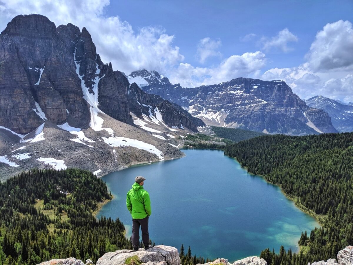
Located so close to the Magog Lake campground, Sunburst and Cerulean lakes are a must-see.
Distinctive Sunburst Peak (also known as Goat’s Tower) looms above both of these brilliantly coloured lakes, offering a most spectacular backdrop.
Sunburst Lake is a very short 10 minute walk from the campground. A cabin sits on the shore of the lake, a legacy to Lizzie Rummel.
Born into German aristocracy, Lizzie started work at Assiniboine Lodge in 1938 at the age of 41. She followed her dreams to open a lodge at Sunburst Lake in 1951 and welcomed guests for 20 years.
Cerulean Lake is another 15 minutes further from Sunburst Lake.
On a calm day, the reflections on the lake’s surface are simply breathtaking. The shore of the lake is the perfect place to stop and relax.

Niblet, Nublet and Nub summit
This trio of peaks offer some of the most epic panoramas in Mount Assiniboine Provincial Park.
Accessible via two trails (one near Elizabeth Lake and the other at a junction between the Lodge and Magog Lake campground), it is possible to hike to the Niblet/Nublet/Nub as a 12km loop with 550m total elevation gain.
From the Elizabeth Lake side, the climb is fairly steep and quick to the Niblet. The ascent from the other direction is a lot more gradual.

Whichever way you go, the effort pays off quickly. The Niblet has stunning views over Mount Assiniboine, Magog Lake, Sunburst Peak, Cerulean Lake and surrounding peaks.
At this point, you have the choice of whether to keep hiking to the Nublet. The trail is steeper here and more rocky.
Of course, the views open up even more.
Continuing to the Nub involves more elevation, significant exposure, some ridge walking and light scrambling. The route is also less defined (it’s easy to lose it).

Wonder Pass Lookout
If you don’t plan to hike through Wonder Pass, this 11km return trip (220m elevation gain) offers the chance to see what you missed.
The trail travels past some impressive mountain peaks and next to a larch-studded meadow before climbing steeply up to Wonder Pass itself. There are stunning views to see both north and south.
After crossing the Alberta/BC border, take the left path to visit a viewpoint overlooking Marvel Lake.

Trail difficulty
I would rate the main routes into the Mount Assiniboine Provincial Park core area, as described in this post, to be moderate difficulty with one overnight stop.
All of the trails feature a significant amount of elevation gain on sometimes uneven ground (mostly dirt, some rock).

There are no real technical features but some sections do involve walking on narrow paths with steep drop-offs.
One of the most notable is the approach to the Valley of the Rocks area on the Sunshine Village route, after the turn-off for Porcupine Campground.

There are several steep sections as well. Part of the descent to Marvel Lake from Wonder Pass is fairly steep.
There is a longer steep section from Citadel Pass to the Porcupine campground junction and then down to the campground itself.
The weather (rain/snow/heat) can increase the difficulty of this trail, especially as there are some exposed sections. Early season conditions (snow, unmaintained trail) can also provide extra challenges.

The longer your itinerary, the easier it will be.
A 6 day itinerary is inherently easier than a 5 day itinerary, though your backpack will be heavier with the extra food supplies. And of course, the lighter your backpack, the easier the hiking experience.
While I think Mount Assiniboine is one of the better options for first-time backpackers in BC, I would still recommend going on an overnight hike first so you can test your gear and stamina in a more controlled environment.
Keep in mind that there are no real ‘escape routes’ in this remote area, except the lodge helicopter (which is not cheap and may or may not have space for you).

When to go
The best time to hike to Mount Assiniboine Provincial Park is late July to early September. During this time, the path is usually snow-free.
Temperatures are warm during the day (low 20s Celsius, sometimes warmer) and cool at night (2-10°C or less). Warm weather can continue into September.
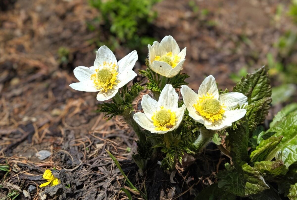
This time period is also ideal for viewing wildflowers. The peak is usually early August but can start earlier and finish later depending on the year.
Please note that weather conditions can fluctuate quickly and often. Snow and freezing tempeatures are possible even in the middle of summer.
Depending on the year, the trails and campgrounds may be snow-free earlier in the summer. The bugs (mosquitoes, deer flies) are generally worse during the early summer season, however.
To check current conditions, take a look at Assiniboine Lodge’s webcam and BC Parks’ latest trail report (scroll down to ‘activities’ and then ‘hiking.’)

Mid to late September is a popular time to hike the trail as it is the time when larch trees turn golden. The area below Wonder Pass is one of the best places to view golden larch in BC.
The exact timing of the golden larch season changes each year as it is completely dependent on the weather.
Keep in mind, however, that September can be a very cold month to hike to Mount Assiniboine. Snow is very possible.

Mount Assiniboine Provincial Park campgrounds
Mount Assiniboine Provincial Park offers more than 75 walk-in tent campsites, distributed between half a dozen campgrounds. Almost all of the campgrounds require reservations.
Magog Lake is the most popular, and therefore most difficult to reserve, campground. It is located by the lake of the same name, just below Mount Assiniboine itself.

Og Lake and Porcupine are commonly used for camping en route to Magog Lake.
Hikers accessing the park via Mount Shark may also want to consider camping overnight in one of the five Banff National Park campgrounds situated en route.

Magog Lake campground
Location: Next to Magog Lake, Mount Assiniboine core area
Facilities: 40 dirt tent pads, semi-enclosed cooking shelters, open cooking area, food caches, bear hangs, two grey water pits, three water taps, five outhouses
Water access: Magog Lake
Campfires allowed: No
Popularity: Very high
Reservation required: Yes during peak season (20th June to 30th September)
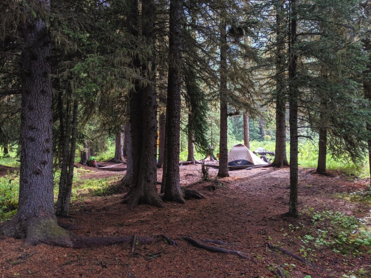
Magog Lake campground is situated close to the lake, about 5-10 minutes walk from most sites. Most of the spots are surprisingly private, with sites clustered into groups (2-4 sites) and separated by trees.

Fires are not allowed anywhere in the campground. Magog Lake campground is a 2km walk (20-30 mins) from Assiniboine Lodge.
There are six food storage locations spread across the campground, some with food caches and some with bear hangs.
There are two semi-enclosed cooking shelters, which are very popular on cold and wet days.

Og Lake campground
Location: 6.6km from Magog Lake, 20.9km from Sunshine Village
Facilities: 10 dirt tent pads, an open cooking area, food cache, grey water pit, outhouse
Water access: Og Lake
Campfires allowed: No
Popularity: High
Reservation required: Yes during peak season (20th June to 30th September)
The tent pads are scattered just above the lake, with most offering direct views of the water. On clear days, it’s possible to see Mount Assiniboine itself!
Og Lake campground is a lot more open than Magog Lake, with mostly low foliage and very few trees.
I personally really like the Og Lake campground.

After visiting it on the way to Magog Lake last time, I decided we should stay here on our second visit. We hiked from Sunshine Village to Og Lake in 7 hours.
When hiking from Sunshine, Og Lake is a decent alternative if you can’t get into Magog Lake for more than one night.
It’s a very easy and flat 5km hike to Magog Lake, so you can arrive early and then explore the core area for the rest of the day.

Other Mount Assiniboine Provincial Park campgrounds
Porcupine
Location: 13km from Sunshine Village, 14.5km from Magog Lake
Facilities: 10 dirt tent pads, an open cooking area, food cache, grey water pit, outhouse
Water access: Creek
Campfires allowed: Yes, in communal fire pit only
Popularity: High
Reservation required: Yes during peak season (required since 2024)
Based on distances alone, Porcupine is the ideal overnight stopover between Sunshine Village and Magog Lake. And it does this job well.
The main downsides are the steep descent from the junction and the ambience of the campground itself.
Simply put, this forested valley campground is not the most scenic place to be on the trail.
Leaving the campground, you have two options – hike back up to the main trail (10.5km to Magog) or take a side route that joins up at the Valley of the Rocks (9km to Magog).
Mitchell Meadows
Location: 7km west of Magog Lake
Facilities: 3 dirt tent pads, outhouse, food cache
Water access: Creek
Campfires allowed: Yes, in communal fire pit only
Popularity: Low
Reservation required: No (and it’s free!)
O’Brien Meadows Group Campground
Location: Northeast of Magog Lake
Facilities: No established tent pads, outhouse, food cache, grey water disposal pit
Water access: Creek
Campfires allowed: No
Popularity: Medium
Reservation required: Yes, 15 people minimum
O’Brien Horse Camp
Location: Northeast of Magog Lake
Facilities: Several established tent pads, outhouse, food cache
Water access: Creek
Campfires allowed: No
Popularity: Medium
Reservation required: Yes (for horseback users only, with a letter of permission)

Banff National Park campgrounds
The following campgrounds in Banff National Park are located on the way to Mount Assiniboine Provincial Park.
Please note that campers must have a Wilderness Permit to stay at a specific overnight backcountry campground in Banff National Park.
This permit must be secured before arrival – there are no self-registration vaults at the campgrounds or trailheads at any of the five campgrounds above.

Howard Douglas Lake SU8
Location: 6km from Sunshine Village
Facilities: 5 dirt tent pads, outhouse, open cooking area, bear hang
Water access: Lake
Campfires allowed: No
Popularity: High
Reservation required: Yes
This campground is set in a forest next to a pretty lake. While it is pretty close to Sunshine Village, this is a convenient place to stay if you have a late start or need to finish early.
We stayed at Howard Douglas Lake on our first Mount Assiniboine, when we wanted to avoid staying in the Porcupine campground twice.
It makes for a long hike from Magog, but I personally thought it was worth it to avoid the additional climbing down and up from Porcupine.

Big Springs BR9
Location: 9.1km from Mount Shark (Bryant Creek) trailhead
Facilities: 5 dirt tent pads, outhouse, open cooking area, food cache
Water access: Creek
Campfires allowed: No
Popularity: Medium
Reservation required: Yes
Some of the tent pads in this forested campground back onto a fast-moving creek. Mountain views are visible from the bridge over the rushing water.
Being that the approach from Mount Shark is mostly flat and easy to hike, this campground is popular with families on overnight trips.
While I think it is a pleasant enough campground, keep in mind that it is only a fast 2 to 3 hour hike to/from the trailhead. It’s not usually really busy for this reason.

Marvel Lake BR13
Location: 13km from Mount Shark (Bryant Creek) trailhead
Facilities: 10 dirt tent pads, two outhouses, an open cooking area, food cache
Water access: Creek
Campfires allowed: No
Popularity: High
Reservation required: Yes
Located almost exactly halfway between Mount Shark and Magog Lake, Marvel Lake campground is the ideal place to stop when hiking the Wonder Pass route.
The only catch is that this forested campground is not actually located next to Marvel Lake. The turquoise shores of Marvel Lake are 1.4km away.

McBride’s Camp
Location: 13.4km from Mount Shark (Bryant Creek) trailhead
Facilities: 10 dirt tent pads, outhouse, open cooking area, food cache
Water access: Creek
Campfires allowed: No
Popularity: High
Reservation required: Yes
McBride’s Camp is also ideally placed for an overnight stop on the way to the Mount Assiniboine core area from the Mount Shark trailhead. There are some peek-through mountain views.
This mostly forested campground is well placed for hikers heading to the Wonder Pass route as well as Assiniboine Pass.

Allenby Junction BR17
Location: 16.5km from Mount Shark (Bryant Creek) trailhead
Facilities: 5 cleared tent stops, outhouse, open cooking area, food cache
Water access: Creek (may dry up in late summer)
Campfires allowed: No
Popularity: Medium
Reservation required: Yes
This campground is the most rustic of those mentioned and is most commonly used by Great Divide Trail hikers. Cliffs tower above the mostly forested sites.
Bryant Creek shelter
There is a basic shelter at Bryant Creek, located 13km from the Mount Shark Trailhead, but it is currently closed pending redevelopment.
Fees and permits
There is no fee to hike in Mount Assiniboine Provincial Park itself, but the majority of the associated campgrounds have an overnight permit fee.
Most hikers travel through Banff National Park and/or the Kananaskis region to access Mount Assiniboine. A valid national park pass is required for Banff and a Conservation Pass for Kananaskis.
Yes, a thru hike of Mount Assiniboine (from Sunshine to Mount Shark) traverses three different districts! It’s really important to get the appropriate backcountry and permits for each one.
If you don’t manage to secure reservations, use a notification service like CampNab to automatically check for cancellations for you. We’ve successfully used CampNab to secure reservations for some of BC’s most popular campgrounds, such as Berg Lake and the Rockwall.
BC Parks camping fees
Magog Lake – $25/per adult/per night ($5/youth/night)
Og Lake – $25/per person/per night ($5/youth/night)
Porcupine – $25/per person/per night ($5/youth/night)
As of 2026, there is an additional $20/stay fee for non-BC residents. It is charged per party.
BC Parks reservation fees
Online – $6/per tent pad/per night, up to 3 nights maximum ($18 total)
Phone – $6/per tent pad/per night, up to 3 nights maximum ($18 total) plus $5 surcharge
Reservations run on a three month rolling window.
Banff National Park camping fees (Wilderness Permit)
Howard Douglas Lake SU8 – $15.00/per person/per night
Big Springs BR9 – $15.00/per person/per night
Marvel Lake BR13 – $15.00/per person/per night
McBride’s Camp BR14 – $15.00/per person/per night
Allenby Junction BR17 – $15.00/per person/per night
As previously mentioned, Banff National Park campers must have a Wilderness Permit to stay at a specific overnight backcountry campground.
The easiest way to secure a permit is to make a reservation (fees and details below). Reservations usually open in January each year.
Banff National Park reservation fees
Online – $11.50/per reservation
Phone – $13.50/per booking

Banff National Park day use fees (park pass) –
Adult – $12.25 per day
Senior – $10.75 per day
Youth and children receive free entry
Visiting the Banff area for longer than seven days? It may be better value to purchase a Discovery Pass.
Discovery Passes are valid for 12 months and include free admission to all national parks in Canada as well as national historic sites.
Discovery Passes are $83.50/adult OR $167.50 for a group (up to 7 adults).
IMPORTANT! From 19th June to 7th September 2026, there are no admission fees for national parks and national historic sites operated by Parks Canada (Canada Strong program).
Kananaskis Conservation Pass
Starting and/or ending at Mount Shark? You’ll need a valid Kananaskis Conservation Pass for your parked vehicle. A day pass is $15 and yearly passes $90. The pass is tied to license plates and cannot be transferred to another vehicle.

Mount Assiniboine reservation system
Almost all of the campgrounds in the Mount Assiniboine area require reservations.
Mount Assiniboine Provincial Park
Magog Lake (in the core area) and Og Lake are the two most popular campgrounds.
Campers must have a reservation to stay overnight in these campgrounds during the peak operating season. In 2026, the peak season is from 20th June to 30th September. This restriction has been in force since 2018.
O’Brien Meadows Group Campground is available by reservation only, 15 people minimum (reserve through Assiniboine Lodge).
O’Brien Horse Camp is for visitors arriving on horseback only.

Hikers without reservations are still allowed to hike to the Mount Assiniboine core area but can only camp at Mitchell Meadows campground, which operates on a first come first serve basis.
Reservation details:
- In 2026, reservations for Porcupine, Og Lake and Magog Lake campgrounds will run with a rolling three month booking window e.g. if you want to arrive on 27th July and stay three nights, you can reserve all three nights starting at 7am PT on 27th May
- Reservation availability refreshes at 7am
- In addition to the $25/night per adult camping fee, there is a $6 per night reservation fee (up to $18 max)
- As of 2026, BC Parks charges a $20 flat fee per stay for non BC residents
- Reservations can be made online or by phone 1-800-689-9025
- If you missed out on a reservation, it’s worth checking often for cancellations
- Making a reservation guarantees a spot in the campground, not a specific tent pad. Individual tent pads are allocated on arrival via a first come, first serve system
- Check in time is 1pm and check out time 12pm
- An on-site Park Facility Operator (PFO) checks reservations and permits
More tips for reserving backcountry camping in provincial parks in BC.

Banff National Park
Backcountry permits are required for the following campgrounds in Banff National Park – Howard Douglas Lake, Big Springs, Marvel Lake, McBride’s Camp and Allenby Junction
The best way to secure a backcountry permit is to make a reservation. It is not possible to get a backcountry permit while on the trail – you must have it before starting.
- The above campgrounds are all reservable via the online Parks Canada Reservation Service. Reservations cost $11.50
- Alternatively, you can call 1-877-737-3783 to make a reservation. Telephone reservations are $13.50
- Backcountry permits cost $15.00 per night, per person. This is charged in addition to the National Parks daily admission fee
- When hiking from Mount Shark, select ‘Bryant Creek’ as your starting trailhead
- When hiking from the core area to Mount Shark, select Wonder Pass or Assiniboine Pass as your starting trailhead
- In 2026, the reservation system launch date for Banff National Park’s backcountry campgrounds is 26th January 2026 at 8am MT
- Marvel Lake and Howard Douglas are popular backcountry campgrounds (not just for Mount Assiniboine hikers) and spots can go fast. I would suggest being ready for reservation launch to secure a spot
- Allenby Junction is the least used campground of those mentioned
- Maximum length of stay is 3 nights at each campsite
Click here to read our tips for reserving backcountry camping in national parks in BC
Mount Assiniboine accommodation
Camping isn’t the only way to stay overnight in Mount Assiniboine Provincial Park. For a more luxurious experience, consider the Naiset Huts or Assiniboine Lodge.

Naiset Huts
The Naiset Huts are a collection of five basic one-room huts located close to Assiniboine Lodge in the core area of the park.
Each hut sleeps 5-8 people, dormitory style on plywood bunk beds with foam mattresses (provided). Guests must reserve the entire hut. Prices range from $150/night to $240/night.
As of 2026, hut users must pay additional fees to BC Parks on top of the hut fee. This aligns with the increased nightly fee at the campgrounds. The fee is $50/per family per night.
The huts have wood-burning stoves, with compressed fire logs available for purchase at Assiniboine Lodge for $7 a piece. There are three shared outhouses and the enclosed Wonder Lodge Cooking Shelter.
This modern log cabin has running water, lighting and two propane cooking stoves. Each hut is allocated an outside food locker for storage.
While owned by BC Parks, the huts are operated by Assiniboine Lodge. Reservations are by phone and online, with the launch happening every January. In 2026, it was 13th January at 8.30am.
The 2027 launch is 12th January at 8.30am MT.
It can still be worth checking for cancellations if you don’t manage to get a spot. There is no waitlist.
Assiniboine Lodge also operates the Hind Hut, a mountaineering cabin located at the base of Mount Assiniboine.
After camping in Magog Lake in freezing temperatures twice, we will definitely be trying to stay at the Naiset Huts next time!

Assiniboine Lodge
Assiniboine Lodge was built in 1915, becoming North America’s first backcountry ski lodge.
With seven cabins, five lodge rooms, indoor flushing toilets, a bathhouse (with sauna!) and all meals included, Assiniboine Lodge offers the most comfortable overnight experience in Mount Assiniboine Provincial Park.

Prices start at $360/night per person for a lodge room, rising to $440+/night per person for a private cabin. Assiniboine Lodge can be booked out up to a year in advance.
Assiniboine Lodge hosts afternoon tea for hikers on Mondays, Tuesdays, Thursdays and Saturdays from 4 to 5pm.
As well as cake, tea and coffee, wine and beer can also be purchased. It’s a lovely treat during a backpacking trip. Be sure to bring cash!

Navigation
Mount Assiniboine Provincial Park is a popular hiking destination and, as such, the three access routes mentioned in this post (Sunshine, Wonder Pass and Assiniboine Pass) are well established and regularly used in the summer months.
These paths are well signed too, with brown national park/provincial park signage at all junctions.
One thing to keep in mind, however, is that the signage usually mentions campgrounds (Magog Lake, Og Lake) and passes (Citadel Pass, Wonder Pass), rather than just ‘Mount Assiniboine.’

In Banff National Park, campgrounds are often referred to with code names e.g. Marvel Lake = BR13. These code names are used on the reservation system and will be listed on your permit.
A significant amount of the trails to Mount Assiniboine are located in exposed areas (few trees) so it is usually straightforward to spot the route ahead. Snow and fallen trees may obscure some sections during the early hiking season.
GemTrek produces a waterproof and tear-resistant map of Mount Assiniboine Provincial Park and the surrounding area.
While hiking, we also used the Organic Maps app, mostly for checking how much more elevation we had to climb or the distance to the next campground. It can be used offline if you download the relevant maps in advance.

Wildlife
Mount Assiniboine Provincial Park is home to a variety of mammals and almost 100 species of birds.
Both grizzly and black bears roam this area, along with mountain goats, moose, mule deer, elk and bighorn sheep. Marmots and chipmunks are easy to spot, along with pika in rocky areas.
Wolverine, badger and coyote also live here but are not often seen. Common birds are the grey jay, white tailed ptarmigan, boreal chickadee and Clark’s nutcracker.
Negative wildlife encounters are rare. Parks Canada promotes coexistence and there are a few things hikers can do to help:
- Make noise while hiking. This alerts wildlife to your presence and gives them a chance to avoid you. As a general rule, animals don’t want to be close to humans
- Leave No Trace. After eating, make sure you haven’t left any food or wrappers at your location
- Store food properly. Feeding animals is illegal and also harmful. This includes accidentally feeding wildlife as well. Use the provided food caches and bear hangs at the campgrounds to store food, cooking equipment and smelly items when not in use
- Give wildlife space. If you do see any animals, keep your distance – ideally 100m or more. This offers them an escape route
- Know what to do if a bear approaches. Depending on the behaviour of the bear, different techniques are required (read our bear safety post for more info)
- Carry bear spray. An aerosol deterrent made with chili pepper oil, bear spray is a ‘last resort’ tool intended to be used only when other methods have failed
As a side note, expect to see mosquitoes and deer flies in the campgrounds and on the trails in July and August. They become more prevalent around sunset.
We have never had major issues with bugs in this area as it’s always been cold on our trips but I know many hikers who have said that the bugs can be ferocious when it’s warm.

Safety information
Mount Assiniboine is a popular provincial park with a lodge, but it is still located in remote mountainous terrain. Hikers must be self-sufficient.
- Weather conditions can vary and change quickly. Snow is possible at any time of the year
- There may be snow on the trail and in the campgrounds until mid-July, sometimes even later
- Water availability is very limited between Howard Douglas Lake and Og Lake on the Sunshine route to Assiniboine. Bring plenty of water, especially when warm weather is forecast
- Some sections (such as Sunshine Meadows) are very exposed, with no trees for shade or cover. Hikers should know what to do in the event of a lightning storm
- There is no phone signal anywhere in this area, except in Sunshine Village. Tell someone where you’re going and when you plan to be back (check out our outdoor safety guide for more tips). We always carry an InReach device in case of emergencies
- Always purify water before drinking. On our most recent Assiniboine backpacking trip, we utilised a gravity hydration bladder system with the MSR Thru-Link In-Line Microfilter
- There may be fallen trees on sections of the trail at any time – this is more common during the early season (July)
- Besides these hazards, it’s also important to stay aware of wildlife, particularly bears

Mount Assiniboine packing list
Backpacking is all about balance – keeping your pack weight low while still ensuring you have everything you need to be self-sufficient and comfortable.
Keep in mind though, that the lighter you pack, the easier (and likely more enjoyable) the actual hiking will be.
Here are all the items we carried to Mount Assiniboine on our most recent trip (you may find our backpacking gear guide helpful to make your own list):
- Backpack – (Osprey Aura AG 65 for Gemma, Osprey Aether 65 for JR)
- Waterproof pack covers
- Tent (Big Agnes Copper Spur 3)
- Tent footprint
- Sleeping bag
- Sleeping pad
- Hiking boots (we both use Salomon Quest 4D)
- Stove (Jetboil MiniMo)
- Fuel (110g isobutane propane)
- Cup (GSI Infinity Backpacker Mug)
- Bowl/plate (we use a folding bowl)
- Utensils (2 x long spoons like this)
- Cleaning supplies (CampSuds and tiny scrubber)
- Food storage container (we used a dry bag)
- 1.1lb of food/per person/per day
- Clothing (see below for more)
- Water filtration (MSR Thru-Link with Aquatabs as backup)
- Water storage (2 x 2l Osprey bladders)
- Communication device (InReach SE+)
- Headlamp (Petzl Actik headlamp with rechargeable battery)
- First Aid kit with Leukotape for blister prevention
- Sunglasses and sunscreen
- Insect repellent
- Knife (this one)
- Emergency matches
- Tenacious tape (for repairs)
- Toilet paper and hand sanitizer in Ziploc bag
- Camera (Pixel 6 Pro)
- Portable battery charger and phone cable
- Bear spray
- Bear horn
- Camp shoes (I love my Teva sandals)
- 5 Dice Game (Yahtzee)
- Printed reservation and map
- Vehicle keys, cash and ID
My Assiniboine wardrobe included:
- 2 x merino t-shirts
- 2 x merino long sleeve shirts (I used one to sleep in)
- 1 x pair of quick drying pants
- 1 x pair of merino wool base layer pants (long johns)
- 2 x pairs of shorts
- 5 x pairs of underwear
- 2 x quick drying sport bras
- 3 x merino wool socks
- Arc’teryx Atom LT Jacket (mostly used as an outer layer)
- Arc’teryx Beta Jacket (waterproof)
- Wool toque
- Light gloves
- Buff neck gaiter

Essential items
Beyond your regular backpacking gear and the 10 Essentials, I’d recommend bringing these items:
- Cash – Assiniboine Lodge usually welcomes hikers between 4-5pm Mondays, Tuesdays, Thursdays and Saturdays for afternoon tea. Beer and wine are also usually available. Purchases must be made with (Canadian) cash
- Warm layers – As mentioned, the weather in the Mount Assiniboine area can change fast. It can be cold even in summer. Bring a mixture of layers, including some warmer clothing (we love merino wool) and waterproofs (jacket)
- Bear spray – The Canadian Rockies are home to both black and grizzly bears. It is imperative to keep alert, make noise and know what to do if you see a bear. Carry bear spray in an accessible place and know how to use it
- Hiking poles – We always hike with at least one hiking pole each. I like using poles for balance when hiking with a pack. They can also help to reduce knee strain when descending. Black Diamond’s Carbon Zs are super light and pack down easily
- Water filter or purification method – Prepare to treat all water sources during your Mount Assiniboine backpacking trip. There are three water taps in the Magog Lake campground but BC Parks recommends treating the water
- Camping reservation confirmation – If staying at Magog Lake, Og Lakes or any of the Banff NP campgrounds, print off your reservation and bring it with you. Keep it dry in a Ziploc bag
- Bug protection – Mosquitoes, deer flies and horse flies can be a real problem in the Mount Assiniboine area, especially in July and early August. Be sure to have repellent and consider bringing a head net
- Visiting from outside of Canada? Be sure to have travel insurance before heading out on this hike. If you’re from the UK, check out True Traveller

Where to stay before or after the hike
Finishing in Sunshine Village? Enjoy the alpine for a little bit longer with a stay at Sunshine Mountain Lodge.
This upscale boutique hotel, situated at 2,400m, is the only one of its kind of Banff. Think gorgeous mountain views, spa-like bathrooms, private balconies and more.

There’s a huge outdoor hot tub as well, perfect for soaking after the long hike out of Mount Assiniboine Provincial Park. To treat yourself even more, consider booking a spa treatment.
There is a choice of three on-site restaurants at Sunshine Village. We enjoyed dinner at the Chimney Corner – more amazing views, elevated cuisine (the best steak JR has had in years) and personable service.

Mount Engadine Lodge is the closest accommodation to the Mount Shark/Bryant Creek Trailhead.
This road-accessible wilderness lodge has all the comforts of civilisation (en-suite bathrooms, electricity, cooked meals, limited wi-fi) in the most one of the most enviable locations around.
Trails start right outside the door, but it’s possible to just enjoy the spectacular mountain views if you’re all hiked out.
All meals are included at Mount Engadine – breakfast, lunch, dinner and afternoon tea as well.
The towns of Banff and Canmore offer a wide choice of accommodation options for Assiniboine-bound hikers.
Moose Hotel is my favourite downtown property in Banff, conveniently positioned right on Banff Avenue, a short walk from many restaurants and shops. It has a good mix of rooms and spacious suites.
A cheaper option is to camp. Tunnel Mountain Village 1 is my top pick in the Banff area as it has showers and is ten minutes to downtown by bus (the outbound journey is free!)
Mount Assiniboine souvenirs


Read these other Canadian Rockies hiking guides next:
Iceline Trail, Yoho National Park
Rockwall Trail, Kootenay National Park
Lake O’Hara, Yoho National Park
Turbine Canyon Loop, Kananaskis Valley
Burgess Shale, Yoho National Park
BC hiking guides:


One half of the Canadian/British couple behind Off Track Travel, Gemma is happiest when hiking on the trail or planning the next big travel adventure. JR and Gemma are currently based in the beautiful Okanagan Valley, British Columbia, Canada. Consider buying us a coffee if you have find any of our guides helpful!
What a superb introduction to Assiniboine Provincial Park, and Mount Assiniboine. For me, it brought back a host of memories when with three other guys in July of 1971 we backpacked into Magog Lake from the head of the Spray Lakes, along Bryant Creek. We did a loop hike to Magog and then returned over Wonder Pass and back down the valley along Marvel and Gloria? lakes to the warden’s cabin and then from there I think it was about a 7 mile hike back to our vehicle on Bryant Creek. It was a marvellous hike. I was amazed at the photos of Magog Lake in this article where the lake water level was so low! Back then of course there were no facilities and we just found a nice level grassy spot in the trees above the lake. Ken Jones was the park warden at the time and he came by a couple of times for chats, usually doing about 13 miles a day patrolling. I don’t have the title handy, but a book was written about him some years back. A fascinating character. Once again, thanks for generating the memories of a wonderful trip way back in 71..
Hi John,
Thanks so much for your comment! I’m so impressed to hear that you backpacked into Mount Assiniboine back in 1971 – I bet it would certainly be different than now. Still as beautiful, there is no doubt. You are absolutely correct that you would have hiked alongside Gloria Lake, I had to shorten the description down but before I edited it, there was a mention of that lake too! I’m so glad you enjoyed the post 🙂
It would be nicer if you had mentioned elevation gain in the description!
Hi Riasat,
There were mentions of specific elevation gains/loss in the original post, but after re-reading, I agree with you that there could have been more within the descriptions so I have edited as appropriate. I hope you found the guide helpful regardless!
Do you know what time the reservations for the campgrounds open at? I know its 2 months in advance, but I cant find the time of day I can first book.
Thanks,
Hi Bryan,
Online reservations open at the same time as the call centre – 7am. Thanks for giving me the heads up to add this into the post!
Hello Gemma and Jean Robert,
I hope this message finds you well and ready for summer. Thank you so much for all the hard work that you have done on this website. It has been my ‘go to’ site for planning my trip to Lake Magog. I am from B.C. and my fingers are crossed that we can travel to Alberta after July 1st.
I will be doing an “in and out” hike from the Sunshine Parking lot and my first night will be at Og Lake. I will not be camping at any of the sites in Banff National Park. Do you know if I still need to register or pay a fee to hike through Banff National Park to get to Og Lake, a B.C. Parks site? Parks Canada was not very helpful and Banff National Park was not answering their phone so I sent them an email. Unfortunately, they have yet to reply. Thank you so much for your help.
Here is a little tip when booking a camp site with BC Parks, if all the sites are book at 0700h wait 16 minutes and try again. I signed on to the BC Parks site right at 0700 only to find all 30 sites at Lake Magog booked. Reservation are only held for 15 minutes to give you enough time to pay. So, at 0716h 6 sites became available.
Take care.
Hi Michael,
So great to hear that you’ve found this post helpful! I appreciate you coming back to let me know – it means a lot!
I have my fingers crossed that you’ll be able to go on your planned Assiniboine trip. I emailed my Parks Canada contact and he confirmed that visitors to Banff National Park always need a valid park pass. The only exception is people who are driving through without stopping.
Thanks for sharing that tip – it is a great one! I noticed this when booking several backpacking trails this year, on both the National Parks and Discover Camping systems. It really is amazing how many sites are initially reserved, only to be available a short time later. I assume it is to do with people using multiple devices (or multiple people) to secure bookings.
Hi Gemma,
Thank you so much for the quick reply and for contacting your Parks Canada connection. I also understand that I will need a park pass when I am staying in Banff the day before and after my hike so I will just purchase a Discovery Pass for $69.19 at https://www.banfflakelouise.com/park-pass-purchase
Thank you again for creating this great site. Stay safe.
it’s was a amazing instruction, i thought it must be group of 4 for hiking on thest trail because of Bear season Haha?
Hi Jeff,
There are some hikes in the Rockies that require groups to be four people or more but this is not true for Mount Assiniboine. The ‘high pass’ on the Assiniboine Pass route is, however, completely closed from 1st August to September due to grizzly bear activity.
Hello Gemma,
I just returned from five nights in the park and I want to thank you again for this very informative site. It was extremely helpful in planning my hike to Mount Assiniboine. I would like to share a few things that might help others that are planning their trip.
1) The main parking lot at Sunshine is closed so you have to park in a small lot outside the main gate. Get there early as the tiny lot fills up fast.
2) I hiked to Og Lake my first day. The hike from the parking lot, up the service road to the lake took 10 ½ hours. It was an extremely hot day and I was lucky to have topped up with 3 litres of water at Howard Douglas Lake. There were hikers that ran out of water and had to hike back to Porcupine.
3) The mosquitoes are BAD. This is the worst mosquito season in six years so bring a head net, good bug spray and wear a light second layer of clothing. The mosquitoes will bite through your first layer of clothing and people were wearing their rain gear in the evening. Try and get your hands on some Picaridin as you can spray your clothing with it.
4) The lodge is open to ‘backpacker trash’ for beer and cold drinks on the days the helicopter does not fly. I believe the days were Tuesday, Thursday, Saturday and Sunday. They open at 1600h and ask you to leave by 1715h.
5) The campsites at Og and Magog are not assigned so you can pick any site. I picked site 40 at Magog and it was very nice. Site 4 has the only real view on the mountain.
6) On my last night I camped at Porcupine. I woke up early and was able to hike up to Citadel Pass before the sun was able to heat up the valley.
7) Beware of how quickly the weather can change. I was hailed on at Douglas Lake and was lucky the thunder and lightning storm passed over me before I hit the open meadow.
8) If you have the time hike up to Windy Ridge and if you’re up to it hike up to the peak. It will give the best view of the park.
9) The hike up to Wonder Peak is a bit of a challenge as it is very easy to lose the path. A GPS app like GAIA will help.
This was an amazing hike and I hope that you find these notes helpful. Stay safe.
“Hike more. Worry Less.”
Hi Gemma and Jean Robert,
Thank you for this wonderful intro to Assiniboine! I have learned a good deal from it for my upcoming trip. I am trying to getting an idea about how big the tent pad at Lake Magog is. I have the MSR Hubba Hubba 2 person tent (do you have the same one? looks like from the photo :-)). Do you think the pad is big enough to fit two Hubba or any other backpack 2 person tent?
Hi Eric! Yes, the tent pads will fit the majority (if not all!) two person backpacking tents. Our tent is a MSR Freelite 2, basically the lighter version of the Hubba Hubba 2.
Hi Gemma — Thank you for the terrific guide. I had a quick question for you — we have reserved a camp site and registered for two individuals. However, one of my friends wanted to come along as well which would mean there are three of us. I assume this should be fine but what would you advise? Let me know, thanks!
Hi Aamir,
Its not a major issue but you will need to pay extra $$ to the park operator at the campground.
Thank you for such an informative guide! Your posts have been so helpful!
Some friends and I are planning a visit in a few weeks and I am wondering if you have any advice about safe places to leave our other luggage while we are backpacking? We aren’t planning to stay in Banff aside from the camping and don’t want to leave valuables in our car. Thanks!
Hi Lilly,
I’m so happy you found this guide helpful! I’m afraid I don’t know of any luggage places offhand – I would suggest contacting hostels in the area as a starting point.
When did you take these photos? Mid or late july perhaps? I’m planning to go july 26th and stay for a few days, and I’m hoping this is a good time to see wild flowers. Seeing the peaks snow dusted like in your photos would be a plus. Did you see wild flowers when you went?
Thanks.
Hi Alisha,
These photos were taken early July, specifically the second week (6th-9th). We did see some wildflowers but it definitely wasn’t the height of it – I would expect this to be late July to mid August. There was quite a lot of snow on the mountains during our visit as there was significant snowfall (20cm+) the day we hiked in.
Thanks so much for the great information. I see from other posts you are adding or substracting information. Of note the White Mountain Adventure company is no longer shuttling hikers from Sunshine Village, Banff etc to Bryant Creek trail head. I called 3 sisters Taxi out of Canmore and they are more then happy to transport campers from trail head to trail head or city to city. Just a note
thanks again I read your posts and have gone on a few trips with the great information provided.
Hi Val,
I’m so glad you’ve found this post helpful, thanks for letting me know. Thanks also for the intel regarding White Mountain Adventure. It’s too bad they have made the shuttle private for now. Hopefully they will reinstate it at some point.
@Val, are you by any chance needing the shuttle/taxi on July 2nd? If so, my husband and I would love to share one with you!
Hi! Thank you so much for sharing all the essential information! Do you know what the conditions in the park are like in late June? I wanted to go around my birthday June 23rd, but I am worried about snow. Also, if I go later in the year but can’t secure a booking at magog or og lake, what route would you recommend?
Hi Phoebe,
I would expect snow in June, especially this year. The snow levels are higher than normal.
Hi,
I really appreciate your detail and kind information. It’s so helpful for my first backpacking.
I booked Mcbride, Magog lake and Marvel lake camp ground for Assiniboine area during mid July. My concern is burner and fuel. Can I use propane or isobutan gas for burner at that area? Or do I have to prepare liquid burner and fuel like gasolin?
Let me know please.
Thanks.
Hi Leona,
Just to confirm (as per my reply to your email), yes, you can use isobutane stoves at Mount Assiniboine. Most backpackers do (we did also). If you’re concerned about performance, by the four season isobutane gas and bring a stove with a regulator.
Hi Gemma,
We have our reservations July 2-6th and I’m really worried with the remaining snow. There are about 3.5 feet left at Sunshine and we only have three weeks remaining. I don’t mind using our spikes but just curious about the trail from Sunshine to Magog and whether it is steep and/or exposed in areas. Would love any advice you have. I saw that it snowed on your trip in.
Thanks!
Hi Linda,
I just saw a memo from BC Parks today (on Facebook) confirming that there is around 150cm of snow on the trail to Magog Lake right now. The route from Sunshine to Citadel Pass is completely above the treeline, so it is exposed in that regard. There is a short climb up to Quartz Hill, then downhill into Howard Douglas campground. The landscape narrows a little here as you go through the pass and then down into the valley. This section features many switchbacks, some steep. Even though we had plenty of snow in Sunshine Meadows, there was none in this valley. For your trip, however, I would expect some (as confirmed by BC Parks, mentioned above). If you don’t go down to Porcupine, the trail then continues on a side slope. There is a fairly steep drop here and the trail is narrow. The alternate route from Porcupine is less exposed. Both trails join to travel through the Valley of the Rocks (plenty of small ups and downs). The trail opens out again at Og Lake and stays wide and flat until Magog.
@Gemma, thank you so much for the detail! I looked on the BC Parks FB page and I can’t find that post. Do you mind letting me know when it was posted? Would like to read it.
Apologies, just went back to check and it was someone who had copied and pasted the latest update from the BC Parks website. You can see it at the top of the page here. It was posted 9th June.
Hi Linda,
Just in case you see this, Assiniboine Lodge recently posted a report – https://assiniboinelodge.com/trail-report
Hi Gemma,
This is an incredibly detailed guide for anyone interested in venturing into the Mount Assiniboine PP. Great work! I sincerely thank you for putting up all this awesome information.
Although this article is quite a bit old now, I landed here searching for the relevant info for planning our trip this summer.
I will cut to the chase. The problem is I and my friend don’t have reservations for any of the accommodation in the core area of the park. August 2022 long weekend is our only shot at exploring it. I have called and spoken to the folks at BC Parks and the Mt. Assiniboine Lodge but (obviously) there’s nothing available for those dates and even for the weeks after.
Since you have explored this area, my question would be this – can there be an itinerary that doesn’t involve staying at the core area of the park but still allowing us to explore much of it without missing much? Studying and researching it for a couple of days, I am fully aware that it wouldn’t be ideal and will involve longer hikes before and after each day of activity. That is exactly why I wanted to ask you this.
Nobody on the internet seems to have shared this information. I am sure there would still be people who hike in without reservations but still manage to do something? I mean if someone gets there and if nights falls, what happens in this situation? I am a photographer and I specifically wish to capture some interesting sunrise/sunset panoramas from atop some areas but that would mean even later in the day and would see us attempting to hiking back to our campsite in the dark which I want to avoid.
Is there a non-reservation campground still close enough to the core area that would allow us to explore the core area in a couple of days and get back relatively easily after sunset compared to the campsites that are several kms far away such as Porcupine campground?
We would have one car but if planning such an itinerary means hiking thru, then maybe we can arrange for a ride back to wherever we park our car (Mt. Shark or Sunshine), but I really really want to do it.
Will greatly appreciate any help/ideas.
Thanks and regards,
Faisal.
Hi Faisal,
Glad you have found the guide helpful. It was published in late 2019 (just a few summers ago) and is regularly updated.
If you haven’t managed to secure a reservation for Magog or Og Lake, you have two options (as mentioned in the post) to camp close to the core area – Mitchell Meadows or Porcupine. These sites are operated with a first come, first serve system with no reservations possible. For your needs, it sounds like Mitchell Meadows would be the best campground to head to. You can see it marked on the park map here.
When hiking into Assiniboine’s core area, you must have a reservation to stay at Magog/Og Lake or be prepared to stay at one of these first come first serve campsites.
Happy trails!
Hey! I am reading on your blog that there is a four month reservation window? I am seeing everywhere else that it is two months before? Can you confirm?
Hi Ben,
Prior to the pandemic, BC Parks used a four month reservation window. During the pandemic, this was changed to two months. BC Parks has indicated a return to this policy (four months) for 2023.
Thanks for your fantastic guide! I was wondering where you stayed in between the Rockwall (Floe Lake) & Assiniboine (Sunshine)? Cheers 🙂
Hi Jacqueline! So glad you found the guide helpful 🙂
That’s a great question. I didn’t include too much info in this post as I figured it was long enough already (!) and I shared the details within our Great Divide Trail post here.
After finishing the Rockwall, we drove our vehicle up to Johnston Canyon frontcountry campground for the night. We returned to the Floe Lake parking lot the next morning to hike up Ball Pass. We then stayed one night each at Ball Pass Junction and Egypt Lake. We were unable to get the Ball Pass Junction reservation for the night we wanted but it worked out for the best anyway as we were able to have showers, wash clothes, enjoy a meal at a restaurant and have plenty of time to resupply before returning to the trail.
Thank you for your write-up on this hike! Four of us are going in early-August and we have two tents, but I have only reserved one tent pad in each of Og Lake, Magog, and Marvel Lake. Do we need two tent pads to accommodate us?
Hi Steve,
Two tents are allowed on each tent pad with four people total in Mount Assiniboine Provincial Park, though it can be a tight fit (the tent pads are a max of three square meters).
Marvel Lake is a different story as it is in Banff National Park, where only one tent is allowed per tent pad.
Hi there!! Heading to Assiniboine late July! In and out of sunshine village.Is there a fee to park at the village? Also, staying at Porcupine campground both ways to break it up(main night at OgLake)….I see there are only 10 sites there-what happens if we arrive and all sites are occupied already?
Hi Laura,
There is no fee to park at Sunshine Village.
If the sites are already occupied at Porcupine (something that does happen), plan to find the most durable campsite surface around the campground and pitch your tent there for one night only. BC Parks allows this at campgrounds that do not require reservations such as Porcupine. This is not allowed at Magog Lake, for example. Follow Leave No Trace principles and try to find a spot that looks like it has already been used for camping before. When we stayed at Porcupine, the sites filled up around 7pm. A few more people arrived after that and pitched their tents in the campground area.
Hi there
Incredibly useful guide and thank you for answering all the comments. I have a similar question as someone prior – we only have one night at Magog Lake reserved (long story) but I was able to make reservations at Marvel Lake and allenby Junction. We are starting from Mt Shark, overnighting in Marvel and then another overnight in Allenby with the hopes that we can drop our bags at our reservation at Magog and hike from Allenby up to Nub Peak and then down to Magog for our night at Magog. We would then hike out to sunshine with a possible overnight at Mitchell Meadows or Porcupine.
So Day 1 Mount Shark to Marvel Lake
Day 2 short hike Marvel Lake to Allenby Junction campground
Day 3 Allenby Junction – Nub Peak – Lake Magog – sleep at lake Magog campground
Day 4 – hike back down to Sunshine either with a night rest if necessary at Porcupine or Mitchell
My question is – is there a campsite closer than Allenby Junction that is on the Canada Parks side (which seems to have availability)?
Hi Hilary,
No, there is no other Parks Canada campground closer to Magog Lake than Allenby Junction. The hike from Allenby Junction to the Magog Lake campground is less than 7km.
On you day 4, I would plan to stop at Porcupine or look for cancellations for Howard Douglas or Og Lake. It’s a long hike from Magog Lake to Sunshine Village, especially if trying to get the gondola down before it closes. If you do go ahead with that plan, be sure to get up early. Mitchell Meadows is in the ‘wrong’ direction and would add more kilometres.