The Juan de Fuca Trail is a 47km coastal hiking trail on Vancouver Island, British Columbia. The challenging route traverses technical forest and beach terrain, with the roaring Pacific Ocean as an ever present backdrop.
Most hikers explore this beautiful trail over four days, spending each night at one of twelve designated campgrounds. These are most often located right on the beach, offering the chance to see unforgettable West Coast sunsets and wildlife.

With multiple trailheads and no reservation system, the Juan de Fuca Trail also provides plenty of flexibility with trip length, start dates and campground selection.
This post will share all of the essential details you need to know to explore this spectacular coastal trail, based on our first hand hiking experience on the trail.

As BC residents, we’ve completed the full JDF and have also returned to many of its day-use areas over the years, giving us a thorough understanding of the route, trail conditions, highlights, and practical tips to help you plan your own adventure.
Here’s the post breakdown (click to skip):
The full Juan de Fuca Trail will reopen on 1st July 2026 after a prolonged closure due to storm damage. See advisories for more details.
This post includes some affiliate links – if you make a purchase via one of these, we may receive a small percentage of the sale.

Backcountry necessities
- Always bring the 10 Essentials
- Know how to stay safe in the backcountry
- Remember to Leave No Trace to help keep the wilderness wild
- Understand how to avoid negative bear encounters
- Trying out backpacking for the first time? Read Backpacking 101
- Check out our packing guide with gear recommendations
- Sign up to our newsletter for a free backpacking checklist
Introducing the Juan de Fuca Trail
The 47km long Juan de Fuca Trail occupies a stretch of Vancouver Island’s southwest coastline. It sits immediately to the east of the better known West Coast Trail.

A quick history
This land is the traditional territory of the Pacheedaht First Nations. Villages and camps have been established on this coastline for time immemorial. Coastal paths would have been used for travel and trade between communities.
In the 19th century, this coastline became known as ‘the Graveyard of the Pacific’ as European ships arrived and sometimes sank in the unforgiving ocean. A telegraph system was built to assist shipwrecked sailors and was later upgraded to a lifesaving trail.
The Juan de Fuca Marine Trail, as it is formally known, was ‘created through the Commonwealth Nature Legacy as an enduring reminder of the 1994 Victoria Commonwealth Games.’ (BC Parks)
The trail is located in Juan de Fuca Provincial Park, named after the body of water (the main outlet of the Salish Sea) located between Canada and the USA.

Overview
The Juan de Fuca Trail winds its way along the coastline, mostly in the forest. The path travels up and over dozens of creeks and along a number of rocky beaches.
Though most popular as a 3 to 5 day thru-hike, the 47km long Juan de Fuca Trail is also utilised by day hikers and overnight backpackers.
There are four main trailheads – China Beach, Sombrio Beach, Parkinson Creek and Botanical Beach.
The Juan de Fuca Trail is a difficult hiking trail, with many technically challenging features. Simply put, it’s not a walk in the park!
Hikers need to traverse deep mud, steep hills, ladders, uneven and rocky terrain, clifftop paths, tree obstacles (giant root systems, fallen trees) and slippery surfaces. New manmade features added over the last few years have made the trail easier, however.
The Juan de Fuca Trail comes under some criticism for being a coastal trail that doesn’t have a lot of beach sections.
While this is true (only 13% of the trail is directly on the beach), I was surprised how close the path stayed to the coastline. The deafening sound of the Pacific can be heard for the majority of the hike.

Juan de Fuca Trail: Quick facts
- 47km long technical coastal trail
- 87% forest, 13% beach
- Around total 1500m elevation gain (similar total loss)
- Difficulty is challenging, due to technical features, elevation gain/loss
- 3 to 5 day thru-hike, with 4 days being standard
- Multiple trailheads, offering shorter options and ‘escape routes’
- Open all year round but temporary closures are common after storm/winter damage
- Main hiking season is May to September
- No reservation system
- Free to hike (camping fees required)
- $10/per person/per night backcountry camping permit
- Dogs are not encouraged but allowed on leash

Hiking the Juan de Fuca Trail: Our experience
We hiked the Juan de Fuca Trail in early June, from the China Beach Trailhead to Botanical Beach.
Our final itinerary looked like this:
- Day 1 – Bus from Port Renfrew to China Beach, hike to Mystic Beach (2km)
- Day 2 – Mystic Beach to Bear Beach (7.5km)
- Day 3 – Bear Beach to Chin Beach (11.5km)
- Day 4 – Chin Beach to Payzant Creek (19km)
- Day 5 – Payzant Creek to Botanical Beach (7km + 3km to Port Renfrew)
I really wanted to travel westbound, to hike the more difficult sections first. We planned to use one vehicle only, so we planned this trip around using the bus.

Our original plan was for a four day trip, but since the bus only travels south in the evening (I like to park at the end of hikes!) it made sense to extend the trip and stay at Mystic on the first night instead.
Starting on a Monday, we avoided the busiest trail traffic. Heading into the weekend, I could easily see how busy the trail gets on the weekend. We stayed at Chin on a Wednesday night with just 6 others. Based on the hikers we passed, it was to host at least 20 on the Thursday night.
June was unusually dry on Vancouver Island so there was less mud on the trail than usual (though still plentiful).

The weather forecast called for four days of sun with the last day being heavy rain. This proved to be mostly accurate with the exception of coastal fog on our second and fourth days day – it was misty and cool for much of the start of both days.
Many of the new trail features were already in place, such as the wooden tent pads at the campgrounds and aluminium bridges over almost every creek.
Construction work was still obvious between Payzant Creek and Little Kuitshe Creek campgrounds, with wood ready and waiting to be transformed into a boardwalk.
We had originally planned to stay at Little Kuitshe Creek on the fourth night. After arriving pretty early (3pm), we decided to push as we knew torrential rain was coming the next day. It worked out for the best as we really liked Payzant Creek!

Our impressions
We were both surprised by how much we liked the Juan de Fuca Trail. I’m not sure why we had relatively low expectations (it happens) but it really did impress us.
I enjoyed the contrast of camping on the beach and in the forest, with the highlight being Chin Beach. The constant sound of the ocean was surprising to me since I thought most of the trail would be too far to hear it.
The difficulty level was approachable enough to me as an ‘experienced’, but not extremely fit, hiker.
We did strike it lucky with the amount of mud on the trail and I can see how damper conditions would make the hiking experience much more difficult.
We were fortunate enough to see a lot of wildlife. Many, many seals plus a black bear and fisher.
With outstanding scenery, flexibility (no reservations needed!), cheap pricing and well organised campgrounds, I think the Juan de Fuca is a great choice for a challenging but rewarding coastal hike.

Juan de Fuca Trail Hiking Guide
Inspired to hike the Juan de Fuca Trail? This section breaks down what you need to know from trailhead info, transportation logistics and campground descriptions to itinerary suggestions, essential items and more!
Location
The Juan de Fuca Trail stretches 47km along Vancouver Island’s West Coast in British Columbia, Canada. It is located immediately east of the more famous West Coast Trail.
The nearest community to the Juan de Fuca is Port Renfrew, situated 3km from the most western trailhead (Botanical Beach). Port Renfrew is 112km and a 2 hour drive from Victoria, BC’s capital city.

Trailheads
The Juan de Fuca Trail has a number of different trailheads and access points.
China Beach is the most eastern trailhead, located at kilometre 0 for westbound hikers (or kilometre 47 in the other direction).
Botanical Beach is the most western trailhead, located at kilometre 47 (or kilometre 0 in the other direction).
There are two other main trailheads situated part way along the Juan de Fuca Trail:
Sombrio Beach is the closest trailhead to the midpoint, situated at kilometre 29 for westbound hikers (or kilometre 18 in the other direction).
Parkinson Creek is located further west at kilometre 37 (or kilometre 10 in for eastbound hikers).
The above trailheads are all clearly signed from Highway 14 and have designated parking areas, outhouses, trail signage, information kiosks and self-registration vaults (cash only).
There are a couple of additional, unmarked places to access the trail from Highway 14, but these should only really be used in an emergency situation.

Parking and access
The China Beach Trailhead has two mid sized parking lots, situated just off Highway 14 (click for Google Maps location).
Be sure to look for the ‘China Beach day use/trailhead’ parking lot, not China Beach Campground, which is just a few minutes drive to the east.
The JDF Trail starts in the first parking lot, located to the right after the turnoff. Note that there is also a short day use trail to China Beach from the second parking lot.

The Botanical Beach Trailhead hosts a large circular parking lot, situated 3km from Port Renfrew (click for Google Maps location). The access road is completely paved but relatively narrow.
There are two trails leading from the parking lot. One leads directly to Botanical Beach (1km, downhill) and is officially part of the JDF Trail. The other heads to Botany Bay first and then to Botanical Beach (1.8km, also downhill).
The Sombrio Beach Trailhead features a large parking area, accessed via a unpaved, downhill 1.7km road from Highway 14. A short 250m path leads to the JDF Trail junction. The beach is another 200m further.
Like Botanical Beach and China Beach, Sombrio Beach is very popular with day visitors.
Parkinson Creek is the quietest trailhead on the Juan de Fuca Trailhead. An unpaved 3.8km road leads to the small parking lot.
As the BC Parks website warns, thieves operate in the Juan de Fuca area. Vehicles have been broken into, gas stolen and catalyst converters removed.
Most JDF hikers do not have any issues with theft. Remove all valuables from your vehicle and leave it as clean/empty/secured as possible.
An alternative is to find private parking. Cynthia Carlsen offers parking on her Port Renfrew property for $20/night. Located less than two minutes walk from the Juan De Fuca Trail Bus stop, it is a very convenient service for those who do not want to take a chance. We were travelling the Island for two weeks and had a lot of gear with us, so we were glad to park at Cynthia’s (as a bonus, there is a food truck on the property…the perfect reward after the hike!)

Transportation logistics
There are multiple ways to plan a Juan de Fuca Trail hike.
If you have two vehicles, planning a thru hike is easy. Park one vehicle at each of your desired trailheads and start hiking!
Some more consideration is needed for hikers with one vehicle only or those with no vehicle at all.

Juan de Fuca Trail shuttle bus
The easiest way to organise a thru-hike (China Beach to Botanical and vice versa) with one vehicle is to utilise the West Coast Trail Express.
This bus provides a daily shuttle between three of the main Juan de Fuca trailheads and Port Renfrew from 1st May to 30th September. An additional 3km road walk is also required from the Port Renfrew bus stop to the trailhead.
In 2026, the one-way fare to travel between the China Beach Trailhead and Port Renfrew is $30/person (subject to change without notice)
If possible, I would suggest parking your vehicle at your finishing point and then taking the bus to your starting trailhead.
I love being able to finish a trail and immediately leave, rather than worry about missing the bus.
The bus leaves Victoria at 6.45am and arrives at the China Beach Trailhead (Highway 14 junction) at 8.05am. It then travels past Sombrio (8.25am), Parkinson Creek (8.35am) before arriving in Port Renfrew at 8.45am.
This outbound service is ideal for eastbound hikers starting at Botanical Beach (though it does mean an early morning!)
The bus then returns to Port Renfrew at 5.45pm, passing Parkinson Creek (5.55pm) and Sombrio again (6.05pm) before reaching China Beach at 6.25pm. It continues onto Victoria (7.45pm arrival).
As you can see, the bus service is less helpful for westbound thru-hikers. If you plan to hike westbound and want to use the bus, there are two main options –
- Start the trail late, hike 2km and camp at Mystic Beach (we did this, would only recommend for months with long daylight hours)
- Park at China Beach and get the bus back from Port Renfrew
Reservations are recommended for the bus because it does fill up on certain dates (usually holiday weekends).

Hike breakdown
This section offers a detailed breakdown of the Juan de Fuca Trail. It should give you a good idea of what to expect while hiking the trail. Keep in mind that recent maintenance and weather can drastically change the condition of the path.
The BC Parks’ difficulty rating of each section relates to the time when the trail was built. The Juan de Fuca Trail has been through a lot of changes since then and my own difficulty rating reflects that.

China Beach to Mystic Beach
Distance – 2km
BC Parks difficulty rating – Moderate
My difficulty rating – Low side of moderate
Elevation: 100m loss
If you’re travelling westbound, the adventure starts here! The Juan de Fuca Trail eases hikers in with a relatively easy downhill forest walk (100m elevation loss).
There are some complex tree root systems to navigate and a few muddy areas, but for the most part, this is straightforward hiking. There is a suspension bridge too, over Pete Wolfe Creek.
Keep an eye on the orange coloured trail markers as the biggest risk here is actually losing the trail. You know that Mystic Beach is close, however, when the roar of the ocean filters through the trees and several boardwalk/stair sections appear.

Mystic Beach to Bear Beach
Distance – 6km
BC Parks difficulty rating – Moderate
My difficulty rating – Moderate
Elevation: 300m elevation gain
Welcome to beautiful Mystic Beach! Turn left after arriving to visit the natural cliff waterfall. The trail continues on the other (western) side of the beach, behind the cluster of tent pads tucked into the forest next to the creek.
The transition from frontcountry to backcountry begins, with a bracing hill to start. There is the start of a series of small ascents and descents that characterises the day. The steepest downhill sections lead to creeks, which are all crossed by bridges.

The path stays very close to the ocean for the entirety, offering peek through views at several high points and sometimes from bridges too.
A highlight is the short clifftop section at the 5.2km mark, which offers a glimpse of the coastline ahead.

The surrounding forest is incredibly lush and features some gorgeous old growth trees. There are a few muddy sections too, as well as some eroding boardwalk.
The finale of this part of the Juan de Fuca Trail is a series of wooden steps and (not quite vertical) metal ladders that descend down a steep cliff. It’s a pretty exciting way to arrive on the shores of beautiful Bear Beach.

Bear Beach
Distance – 2.5km
BC Parks difficulty rating – Moderate
My difficulty rating – Moderate
Bear Beach is 2.5km long, with the terrain consisting of small rocks and sand. Larger rocks are found closer to the ocean. Be careful to watch your footing, especially when conditions are wet.
The first campground (Bear Beach East) is found just 10-15 minutes walk from the access point, on the other side of a creek.

The Juan de Fuca Trail’s first tidal obstacle is just around the corner. Tall cliffs rise above the beach, completely blocking the path when the tide is high. There is no detour route, so waiting is necessary if you reach here at the wrong time.
Passing the end of the cliff section, look out for pieces of the D.L. Clinch shipwreck which ran aground on the beach in 1860.
There is an emergency exit trail leading from Bear Bear’s Centre campground to Highway 14. It is marked with pink flagging tape.

The exit from Bear Beach is lies just beyond the last campground (Bear Beach West). Check out the unique ‘Rock-on-a-Pillar’ formation just offshore.
The trail is found on the other side of the creek outflow, as indicated by orange markers, buoys and brown trail signage. If you reach the cliffs, you’ve gone too far.

Bear Beach West to Chin Beach Centre
Distance – 10.5km
BC Parks difficulty rating – Most difficult
My difficulty rating – Most difficult
Elevation: 600m gain
BC Parks rates this as the most difficult part of the Juan de Fuca Trail. Based on the physical challenge (elevation gain, technical terrain), I would also agree.
This section features just over a dozen steep ascents ranging from 30 to 70m in elevation gain.

To add to that, most of these climbs are almost immediately followed by steep descents down to creeks. Such is the nature of hiking in coastal forests!
On the upside, as of 2023, all of the creeks are crossed by sturdy wooden or aluminium bridges. The path is also surrounded by beautiful forest, with some impressive stands of old growth trees.

There are peek through water views to be found as well and, of course, the sound of the ocean is ever-present.
The first climb starts immediately from Bear Beach and is also a bit of a muddy one. A series of relentless descents and ascents continues for 2km, before an unusually flat section. Enjoy the break – the rest of the trail resumes its previous style.
There are some trail improvements on this section, including some short boardwalks and stairs.

Obstacles still remain, however, including plenty of muddy areas (with some very deep sections!), tree root staircases, overgrown salal bushes and collapsed pathways.
The trees start to thin out on the top of a bluff, the location of the new Chin East Campground. A wooden staircase leads down to Chin Beach from here. It’s an easy 300m stroll across pebbles and sand to the main campground, as long as the tides are right to pass the cliffs (the JDF’s second tidal obstacle).

Chin Beach Centre to Sombrio Beach
Distance – 5.8km
BC Parks difficulty rating – Difficult
My difficulty rating – Moderate to very difficult
Elevation: 250m elevation gain
This section of the Juan de Fuca Trail has five distinct parts. The biggest climb on the trail is found here, but for most, that may not be the most significant challenge of the day. Here’s the breakdown.

The remainder of the beach is an easy walk across pebbles, again, as long as the tide is low enough to pass another stretch of cliffs (tidal obstacle three). Exiting the beach is a bit tricky, with a short rock scramble required.
The next part of the trail is a meander through the forest, with a couple of short (yet steep) hills. There is a creek crossing as well, one of the very few on the JDF Trail without a bridge. It could be very slippery in wet conditions.

There’s a bit of mud, some old growth, ocean views, a tiny creek crossing and some flat stretches.
The impressive Loss Creek Suspension Bridge (look left in the middle to spot sea stacks!) signifies the start of the biggest ascent on the JDF. Switchbacks help gain 150m in less than 800m. Yep, it’s steep, but it’s over fairly quickly.

It is followed by a wonderfully level section, set deep in the forest (no roaring ocean here). Part of this follows an unusual elevated ridge, which is descended via wooden stairs.
The conclusion of the trail, the final 1.2km of trail to Sombrio Beach, is remarkably challenging.

The technical factor amps up to 10 around Sombrio Point, with a couple of big tree obstacles to navigate, some major mud pits and rocky sections.
The path is narrow and follows a steep cliff, but has recently built fence protection along the highest areas.

The views of Sombrio start to appear, as well as some gorgeous bluffs. Keep an eye out for the cliff waterfall and another by the bridge.

Sombrio Beach
Distance – 2.2km
BC Parks difficulty rating – Moderate
My difficulty rating – Easy
The Juan de Fuca Trail pops out onto Sombrio Beach right by the famed ‘Hidden Waterfall.’
Follow the rushing water up the creek (look for the huge pile of driftwood on the beach) to find a beautifully cascading waterfall at the end of a mossy canyon.
Back on the beach, the Sombrio Beach Far East Campground sits on the other side of the creek. It’s sandy and easy to walk, something that becomes a little trickier around the corner. The pebbles are larger and slide around more.

Sombrio is the longest beach on the Juan de Fuca Trail and the views are spectacular.
Expect to see plenty of day trippers, surfers and tents here. The Sombrio East Campground and main campground blend into each other.
The trail briefly heads inland to connect with the Sombrio Trailhead and then crosses the river with the help of another suspension bridge.
A short up-and-down section and the trail arrives at Sombrio Beach West Campground and travels through it to the beach.

Sombrio Beach Far West Camp to Little Kuitshe
Distance – 4km
BC Parks difficulty rating – Moderate
My difficulty rating – Moderate
Elevation: 140m gain
This is one of the more straightforward sections of the Juan de Fuca Trail, as long as the tides are right.
The western side of Sombrio Beach consists of layers of large and mid-sized rocks. Again, be very careful with your footing, especially in wet weather. Look out for metal shipwreck pieces here as well.

At high tide, the beach is pretty narrow. The next tidal obstacle is found only a few hundred metres from the campground. The high cliffs prevent progress at high tide. There is no detour route.
Another tidal obstacle is found just another 500m along the beach. The seaweed covered bluff can be difficult to get round without getting your feet wet, even at lower tides. There is apparently a forest bypass trail but we did not find it. MBGuiding reported a slope failure making it inaccessible at one point.

More cliffs lead to the exit point, which is marked with colourful buoys hanging from a tree. Heading slightly inland, the trail then meanders in and out of the forerst and along the top of the cliffs.

There are some small ups and downs, ocean views, another suspension bridge (check out the waterfall inland!), a surge channel, deteriorating boardwalk and lots of overgrown salal to push through.
Little Kuitshe Campground sits in a dark forest close to the ocean. There are no views from the camping area, but a steep trail leads down to a rocky outcrop above the water.

Little Kuitshe to Payzant Creek
Distance – 7km
BC Parks difficulty rating – Moderate
My difficulty rating – Low side of moderate with new boardwalk
Elevation: 60m gain
The trail to Payzant Creek stays in the forest for the majority of the route, with a handful of lookouts. It is a journey of countless small ups and down, reflecting the amount of creeks along the way.

At the time of our hike, there was a lot of work currently being done on this section of the JDF Trail.
I’ve heard from other hikers that this section is known for being very muddy. It looks like the new boardwalk will alleviate most of the worst spots.

Around the halfway mark, the trail moves further inland. There is a long flat section leading to, and continuing beyond, Parkinson Creek Trailhead. An unpaved road travels from here to Highway 14 (3km, 190m gain).

Interpretive signage starts to appear as the path winds its way back to the coast.
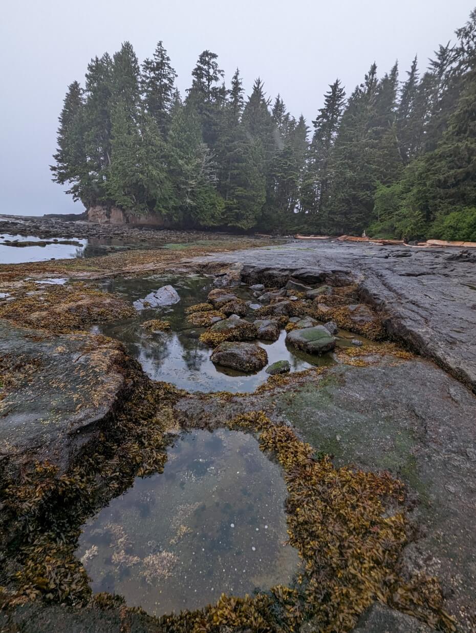
There is an access point onto a rocky reef shelf 1km after leaving Parkinson Creek Trailhead. This is an interesting place to explore at low tide (on dry days); the combination of the grey rock and seaweed looks almost looks otherworldly!

It is possible to walk along the reef shelf for 500m/1km in the westbound direction (the exits are marked with only singular buoys). Keep in mind that the rock is not completely flat; there are many channels and pools to navigate around. We had to do a bit of scrambling to return to a safe route.
The final approach to Payzant Creek Campground winds through a lush old-growth rainforest, with huge trees, ferns and plenty of moss.

Payzant Creek to Botanical Beach
Distance – 7km
BC Parks difficulty rating – Moderate
My difficulty rating – Moderate
Elevation: 100m gain
Old-growth trees and beautiful ocean views abound on this section of the Juan de Fuca Trail. It also features short sections of mud, disintegrating wooden staircases and slippery, broken boardwalk.
Continuing through the temperature rainforest from Payzant Creek, a side trail soon appears for Providence Cove (300m return).

This is a good place for a break or lunch if hiking between Little Kuitshe and Botanical Beach. I wouldn’t recommend it on a wet day, however, as the trail is very brushy.
The path returns to the ocean 800m after the Providence Cove junction. There is access to another rocky reef shelf here, which you can walk westbound for approximately 100m. The rocks are very slippery in wet weather.

From here, the Juan de Fuca Trail sticks close to the coast, providing plenty of peek through views as well as some bluff lookouts.
Some sections of the trail are very open while others are choked with overgrown foliage. Remember to look up to see huge trees!

At kilometre 45.5, there is another opportunity to explore another rocky reef shelf. Alternatively, stay on the forest trail.
Around the next corner is Botanical Beach, famous for its uniquely rich tide pools filled with marine creatures and plants.
We hiked between the rocky reef shelf and Botanical Beach at low-ish tide and it was very slippery, so keep that in mind if you consider it.
A wide 1km long trail leads from Botanical Beach up to the main parking lot. And that’s the end of the Juan de Fuca Trail!
Alternatively, you can explore more of the coastline on the Botany Bay Trail. It is an additional 700m and finishes in the same parking lot.
Itinerary suggestions
Need some inspiration for your own Juan de Fuca Trail adventure? Here are some ideas for you. I have listed each itinerary in a westbound direction – switch it around for eastbound.
Most popular four day itinerary
- Day 1 – China Beach Trailhead to Bear Beach (9km)
- Day 2 – Bear Beach to Chin Beach (12km)
- Day 3 – Chin Beach to Little Kuitshe Creek (12km)
- Day 4 – Little Kuitshe Creek to Botanical Beach (14km)
This is the standard Juan de Fuca Trail itinerary that most hikers follow. It divides the harder sections as evenly as possible. Plan to spend 4 to 6 hours hiking each day, depending on your fitness and preferences.
Steady five day itinerary
- Day 1 – China Beach Trailhead to Bear Beach (9km)
- Day 2 – Bear Beach to Chin Beach (12km)
- Day 3 – Chin Beach to Sombrio Beach (8km)
- Day 4 – Sombrio Beach to Payzant Creek (11km)
- Day 5 – Payzant Creek to Botanical Beach (7km)
If you have the time, consider a five day itinerary. This is ideal for anyone fairly new to backpacking or hikers who want to chill out a bit. Sombrio Beach is a favourite overnight stop of many. The first few days will take around 4 to 6 hours, with the latter 2 to 4.5 hours.
Alternative five day itinerary
- Day 1 – China Beach Trailhead to Mystic Beach (2km)
- Day 2 – Mystic Beach to Bear Beach (7km)
- Day 3 – Bear Beach to Chin Beach (12km)
- Day 4 – Chin Beach to Little Kuitshe Creek (12km)
- Day 5 – Little Kuitshe Creek to Botanical Beach (14km)
This is the five day itinerary we followed. This works well for westbound hikers taking the evening bus to China Beach (recommended for days with long hours of daylight only).
Depending on your morale/speed, consider pushing onto Payzant Creek (like we did). It’s a long day but the section between Little Kuitshe and Payzant is relatively straightforward, especially as more and more boardwalk sections are added.

Leisurely six day itinerary
- Day 1 – China Beach Trailhead to Mystic Beach (2km)
- Day 2 – Mystic Beach to Bear Beach (7km)
- Day 3 – Bear Beach to Chin Beach (12km)
- Day 4 – Chin Beach to Sombrio Beach (8km)
- Day 5 – Sombrio Beach to Payzant Creek (11km)
- Day 6 – Payzant Creek to Botanical Beach (7km)
Savour the Juan de Fuca Trail experience with this six day itinerary. Novice backpackers and those with young families may enjoy the steady pacing.
If you have an extra day, consider staying at Little Kuitshe Creek as well. Alternatively, skip the stay at Mystic Beach and swap in Little Kuitshe on the second to last night.
Fast three day itinerary
- Day 1 – China Beach Trailhead to Bear Beach (9km)
- Day 2 – Bear Beach to Sombrio Beach (20km)
- Day 3 – Sombrio Beach to Botanical Beach (18km)
Experienced hikers may want to consider this three day itinerary. The second day is the most difficult but it ends with a night on beautiful Sombrio. While the final day is fairly long, it traverses the easiest terrain.
We met quite a few eastbound hikers following this itinerary, especially those who had taken the JDF Trail bus to Port Renfrew.

Alternative three day itinerary
- Day 1 – China Beach Trailhead to Chin Beach (21km)
- Day 2 – Chin Beach to Little Kuitshe Creek (12km)
- Day 3 – Little Kuitshe Creek to Botanical Beach (14km)
This alternative three day itinerary may work better for experienced hikers who like to start with a bang. Plan to start early so you can have a good break at Bear Beach before tackling the most difficult section of the trail to Chin.
Half trail three day itinerary
- Day 1 – China Beach Trailhead to Bear Beach (9km)
- Day 2 – Beach Bear to Chin Beach (12km)
- Day 3 – Chin Beach to Sombrio Beach (8km)
Don’t have the time to tackle the full trail? Consider hiking the eastern section only, from China Beach to Sombrio Beach. This is the most challenging but also the most varied part of the trail.
Overnight itineraries
My top picks for overnight trips on the JDF trail would be:
- China Beach to Bear Beach, 23km return
- Sombrio Beach to Chin Beach, 16km return
These include some of the most scenic sections, along with plenty of technical terrain. The beach campgrounds are a welcome reward.
Absolute beginners may enjoy an overnight stay at Mystic Beach. It’s a pretty destination, the trail is easy and maintained and the distance is very short (2km).
For a longer trip, consider Botanical Beach to Payzant Creek (14km round trip) or Parkinson Creek to Sombrio (16km round trip)

Difficulty
Overall, the Juan de Fuca Trail is a challenging coastal route. This is based on the technical nature of the hiking, which involves mud, tree obstacles, slippery surfaces, steep hills and rocks.
To put it simply, the terrain is rough, ever-changing and almost constant attention is required. While there are some flatter sections, expect to step up and down often.
If you usually hike at 5km/h, prepare for this to drop to 3-4km/h. I usually hike at 3-4km/h on most backpacking trails, but travelled at 2-3km/h on the JDF.
Unusually for a BC coastal trail, the JDF features a fair amount of elevation gain (around 1,700m). This provides an additional challenge.
Not every section of the Juan de Fuca Trail is difficult. There are some easy walking sections, both in the forest and on the beach. These are mostly short but provide a welcome break.

With all this in mind, I do believe that the Juan de Fuca Trail is easier than it used to be.
Prior to the 2023 summer hiking season, aluminium bridges were placed onto almost major creek crossing. Only a couple remain on the beach sections, but these are relatively straightforward to cross as long as the creek isn’t flooding.
The ladders at the eastern end of Bear Beach also remove what was once a major obstacle.
In addition to that, the new boardwalks around Little Kuitshe Creek/Payzant offer a much drier hiking experience. When finished, this section should be significantly faster to hike.
Finally, it is important to keep in mind that one storm can make a huge difference regarding the JDF’s difficulty.
One of the hardest obstacles during our hike involved a detour around a recently damaged part of the trail (we had to use a rope to descend a steep hill).

JDF vs. WCT
Already hiked the West Coast Trail and wondering how the JDF compares? Or perhaps you’re thinking of hiking the Juan de Fuca before attempting the WCT?
Personally, I found the JDF easier overall than the WCT. I have met other hikers that have said they found the JDF more difficult. I believe that this is partly due to potentially wetter conditions (we hiked during a dry June) but also related to the recent trail developments, as noted above.
The most difficult sections of the JDF offer similar challenges to the hardest sections of the WCT (mud, tree obstacles, slippery surfaces, rocks, ladders). The JDF has significantly more elevation gain than the WCT, however, something that offers an additional challenge.
Having said that, I still think that the WCT’s forest sections between Gordon River and Walbran Creek are more technically difficult than anything on the JDF (bigger tree obstacles, bog, more broken infrastructure).
As it is now, I think the Juan de Fuca Trail is an excellent training/taster hike for the West Coast Trail. It is shorter with some easier sections and has several ‘escape routes’ if things go wrong. Best of all, no reservation required!

Tides
The Juan de Fuca Trail features some mandatory beach sections as well as some optional ones.
There are six tidal ‘problems’ along the route, referring to areas on the beach that are unsafe (i.e. underwater) to hike at certain tides. JDF hikers therefore need to understand how to read a tide table and be prepared to hike according to it.
On Vancouver Island’s west coast, there are two high and two low tides every 24 hours or so. The timing of these high and low tides changes every day.
Tide tables display predicted tide heights throughout the day in one particular coastal area. Not only can tide tables to work out when it is safe to cross a particular tide problem, they are also helpful to refer to when camping on the beach.
The best tide tables to use for the Juan de Fuca Trail are those produced for Port Renfrew.
The six tidal problems on the Juan de Fuca Trail are as follows:
| Location | Kilometre marker | Passable below |
| Bear Beach | 8.7 | 3.00m/9.8ft |
| Chin Beach (East) | 20.6 | 2.75m/9.0ft |
| Chin Beach (West) | 21.3 | 2.75m/9.0ft |
| Sombrio Beach (East) | 28 | 3.00m/9.8ft |
| Sombrio Beach (West) | 19.6 | 2.60m/8.5ft |
| Sombrio Beach (West-West) | 30.2 | 3.00m/9.8ft |
The locations and passable heights are marked on this BC Parks map.
The tidal problems at Bear Beach, Chin Beach (West), Sombrio Beach (East) and Sombrio Beach (West) all feature high cliffs and have no detour routes, so hikers arriving at high tide need to wait.

There is apparently forest detour routes for Chin Beach (West) and Sombrio Beach (West-West) but didn’t spot either.
Chin Beach (West) features cliffs and a rocky cliff exit, while the Sombrio Beach tidal problem is a bluff. We arrived at the latter well below the stated tides but still found it tricky to cross without getting wet as the area is very slippery.

When to hike
The Juan de Fuca’s main hiking season is May to September. The busiest time is July and August, when the weather is warmest and driest.
May, June, September can also be warm, but also wet. Periods of heavy rain are common, though the amount of rain varies from year to year.
The year we hiked it, the spring had been very dry with only a few days of heavy rain during the entirety of May and June.

The difficulty of this trail increases with wet weather. Heavy rain produces mud and can also cause creeks to flood. The beach sections are slippery in rain. High winds and strong waves can also make the tidal obstacles more challenging to pass.
April and October are typically very wet months and hence are less popular months to hike the trail.
Unless closed for maintenance or damage, the Juan de Fuca Trail is usually open all year round (always check recent advisories before planning a trip!)
For the last few years, BC Parks has consistently closed a portion of the trail for maintenance. This typically happens in March, with the closure continuing until May or longer.
Due to the lack of daylight, high probability of heavy rain and possibility of storms, I would not recommend attempting to thru-hike the JDF from November to March. Short sections are still appropriate for day hiking at this time – Mystic Beach being a good example.
As mentioned at the top of this post, the trail is currently closed due to 2024/5 winter storm damage. It is not known when it will fully reopen.

Campgrounds
There are 6 backcountry camping areas on the Juan de Fuca Trail, divided into 12 designated campgrounds. Each of these campgrounds hosts multiple spots for tents.
Campgrounds are allowed at beach campgrounds when there is not a fire ban (check the BC Wildfires Service website first).

Mystic Beach – kilometre 2
Mystic Beach Campground is only 2km from the China Beach Trailhead, making it an ideal place for hikers starting late or those who really don’t want to finish!
The rocky beach is quite small but has a beautiful natural waterfall at the eastern end.
10 wooden tent pads were built in the spring of 2023, with 6 located in a tight cluster just up and behind the beach on the westbound trail. The remaining 4 are found along the trail itself, with the final two being the most private.
It is still possible to camp amongst the driftwood on the beach, though be sure to stay close to the forest and check the high tide times.
There is a metal food cache situated next to the 6 tent pad cluster, above the creek. There is a second cache found further east along the beach.
Two outhouses sit high above the beach, in between the metal bear cache and eastern entrance. It’s a bit of a walk from the main tent area.

Bear Beach East
Bear Beach is a long sweeping beach, featuring larger rocks, pebbles and some sand too. It is an excellent destination for camping, with plenty of space and three designated campgrounds.
Bear Bear East Campground is just 10-15 minutes walk from the ladders at the end of the beach. 5 wooden tent pads sit next to Rosemond Creek, grouped together with an outhouse and metal food cache.

While there is some forest cover, the campground still feels quite open. There are a couple of flat spots next to the pads for small tents, with other options on the pebble beach as well.

Bear Beach Centre – kilometre 9
Bear Beach Centre is a sprawling camping area; it almost feels like three campgrounds in one!
We chose to stay here as we felt it offered the best beach and ocean views overall compared to the West and East areas.
There are two wooden tent pads hidden in the trees on the eastern side of the campground. On our visit, there was almost a stash of cut firewood here as well. These tent pads are individually surrounded by trees and are very private.

A metal food cache is situated just around the next corner to the west. Follow the trail into the forest to find three decently spaced wooden tent pads. There is additional flat space in the trees and on the beach for tents.
The outhouse is tucked away behind brush on the west side of Clinch Creek. There is a large flat, sheltered area close to the outhouse. Although a bit stinky in places, this spot is still popular as it offers unobscured views of the ocean.

Bear Beach West
The final campground on Bear Beach is found at the very western end, just before the trail heads inland. Bear Beach West features a sloping pebble beach looking out onto the unusual ‘Rock-on-a-Pillar’ formation.

There are no wooden tent pads here. The best area for camping is on a flat-ish area next to the forest. The outhouse sits alongside, with a bear cache tucked into the foliage. I’ve heard that this beach has become even smaller in the last year or so.
We originally intended to camp here but changed our minds after seeing it. I found the view a bit limiting and the beach strewn with a lot of driftwood and seaweed. I imagine it is used less now with the construction of tent pads elsewhere on the beach.

Chin Beach East
Previously the location of an emergency shelter, Chin Beach East is the newest campground on the Juan de Fuca Trail. I believe it would be a great option for groups, especially with the main Chin Beach camp being so busy.
Situated in the forest at the top of a cliff, some of the 5 tent pads have spectacular views of the ocean below. Unfortunately, most of the pads are also very close to the outhouse.

As noted, this campground is very new. The tent pads did not yet have metal hooks on the side when we visited. We also couldn’t find a metal food cache, but I heard that one hiker located it.
The real downside of this campground is the lack of water source. You’ll need to gather water elsewhere when staying here. There also isn’t much space to squeeze in additional tents.

Chin Beach (main) – kilometre 21
Chin Beach is a gorgeous stretch of pebble and sand. Situated in the middle of the most difficult sections of the Juan de Fuca Trail, it is a very popular place to stop. Unfortunately, the (safe) camping area is relatively compact. Plan to arrive early if you’re concerned about getting good spot.

Chin Beach Campground is located in the middle of the beach. There is a small forested area on the east side of the creek, with space for a few tents.
On the other side of the creek, there are three wooden tent pads in front of two outhouses and the metal bear cache.

Another wooden tent pad is hidden in the forest just to the west and offers a view of the ocean. There is enough flat space around this tent pad for another few tents as well.
There are additional tent spots further along the western side of the beach, with some flat areas hidden behind driftwood.

Sombrio Beach Far East
Sombrio Beach Far East Campground is located almost immediately after arriving at Sombrio Beach when hiking westbound. It is just a few steps from the entrance of Sombrio’s famed Hidden Waterfall (with the creek also being the nearest water source).

There is space for around half a dozen tents above the high tide line here, with driftwood providing some dividers in the sand. An outhouse and metal food cache are found behind the beach.
I really liked the look of this campground and think it is one of the better options for Juan de Fuca hikers on Sombrio Beach. Keep in mind though that it does receive a good amount of traffic due to its proximity to the Hidden Waterfall (be prepared for being asked directions often!)

Sombrio Beach East
The next campground on Sombrio Beach is just around the corner. Sombrio Beach East is a sprawling camping area, with plenty of tent spots at the edge of the forest.
Being so close to the Sombrio Trailhead, this is a busy place to camp. It acts as an overflow from the main camping area. Expect to see surfers catching waves in the ocean.
There is an outhouse and metal food cache behind the beach.

Sombrio Beach (main)
The main Sombrio Beach Campground is easily accessible from the Sombrio Trailhead (500m) and is a favourite destination of surfers and families.
As with Sombrio Beach East, there is a good choice of flat spots near the forest and also closer to the water (look for the high tide line). There are two outhouses and food caches at the main beach access point.
With Sombrio Beach being so long, it doesn’t usually feel too crowded. But if you’re looking for more solitude, I’d head to the Far East or West camp instead.

Sombrio Beach West
Sombrio Beach West is located on the other side of Sombrio Creek, which is crossed by a suspension bridge. The Juan de Fuca Trail leads right through the campground to a mandatory beach section.

5 wooden tent pads and a metal food cache are perched just above the rocky beach. The surrounding brush offers some wind protection. Another (slightly damaged) tent pad is tucked away at the back of the campground, past the outhouse.
This campground is my top pick for Juan de Fuca Trail hikers looking to stay at Sombrio. It’s close enough to the action but far away enough to still be quiet.

Little Kuitshe Creek – kilometre 33
Little Kuitshe Creek is a small campground set into a dark forest, just downhill from the main trail. The ocean is close but there is no view from the main camping area.
There are 10 wooden tent pads in the trees, all relatively close to each other. The outhouse and metal food cache are close to the main trail. The nearest creek is found a few minutes walk to the west.

A very steep but short trail leads from the campground to a rock outcropping. Other hikers told us that they enjoyed watching bears and seals from here.
We were originally going to stay at Little Kuitshe Creek but decided against it after arriving relatively early. The forest wasn’t very inspiring and the campground was already busy (school group). As you can see from the above photo, the tent pads are located quite close together.

Payzant Creek – kilometre 40
Payzant Creek is the last campground on the Juan de Fuca Trail in the westbound direction. Like Little Kuitshe, it doesn’t have an ocean view but it is situated in a beautiful old-growth forest.
There are 10 nicely spaced wooden tent pads, most of which are individually bordered by huge trees and brush.
The nicest spots, in my view, are the three tent pads above the creek. The sound of the rushing water is quite soothing. The furthest tent pad even has a view of a waterfall.

The outhouse and metal food cache are located at the trail junction. The creek is just downhill from here.
After three nights on the beach, we really enjoyed our night at Payzant Creek. It provided a great contrast and a fuller ‘Vancouver Island experience.’ On the downside, the forest can be buggy. We had repellent but didn’t bother using it.

Fees and permits
The Juan de Fuca Trail is free to hike. There is, however, a requirement to buy a backcountry camping permit for each night you spend along the trail.
BC Parks charges $10/per person/per night for a backcountry camping permit in Juan de Fuca Provincial Park (subject to change without notice).
I would recommend paying your backcountry camping permit online, before heading to the trail. You can do this up to two weeks before your start date. Otherwise, pay at the trailhead in cash.
To pay online, head to the BC Parks reservation website and click the Backcountry tab. Select ‘Backcountry Registration’ and then ‘Juan de Fuca’ on the drop down menu. Choose your dates, party size and starting trailhead.
Please note that the Juan de Fuca campgrounds work on a first come, first serve system, with no reservation system. Paying for your camping permit in advance does not guarantee that a campsite in a specific area will be available. BC Parks issues an unlimited number of backcountry camping permits for the JDF Trail.

Navigation
With the JDF Trail being a well-travelled route, it is, for the most part, straightforward to navigate. There are numbered kilometre markers along the entire route (albeit with a few missing), starting at 0 at China Beach.
Being a coastal trail, you will almost always be travelling with the ocean on your left or your right, depending on which trailhead you start at.
Direction is less obvious during some of the more inland forest sections, but the path is usually clearly packed down. Orange trail markers appear every 20-50m or so and are typically attached to trees.
Trail detours around recently fallen trees can be tricky to navigate. Look for orange flagging tape in the trees or attached to man-made structures.
There are a number of trails leading away from the JDF Trail. These are usually signified with pink flagging tape. Be careful not to accidently follow these.

Coastal trail section access points are usually marked with colourful buoys in the trees, some featuring trail signage as well (with tide tables).
We found that some of the coastal access points were not signed particularly well, especially when compared to the West Coast Trail.
We walked right past a few of the exit points, such as the forest bypass trail at the Sombrio West-West tidal obstacle.
BC Parks produces a reasonably detailed map of the JDF Trail, with campgrounds, tidal obstacles and creeks marked.
The Juan de Fuca Trail is featured on our favourite hiking app, Organic Maps. I can report that the mapped route was accurate in 2023. Downloaded maps can be used offline.

Wildlife
The Juan de Fuca coastline is home to a variety of mammals and many different bird species.
We spotted seals swimming in the surf just offshore at every beach campground we stayed at. We also saw a black bear on West Sombrio Beach – they commonly utilise the beaches to travel and find food.

In the forest, we heard several owls and at least a dozen different species of birds.
Some lucky Juan de Fuca hikers spot whales from shore. We didn’t see any but felt fortunate to have the chance to watch a fisher (a bit like a large weasel) hunting for crabs and fish at Bear Beach.
Negative wildlife encounters are rare on the Juan de Fuca Trail. To help continue that:
- Always make noise while hiking to help alert wildlife to your presence
- Give them space. If you do see any animals, keep your distance (ideally 100m or more) and offer them an escape route
- Store food overnight and when not in use. There are metal food caches at each of the designated campgrounds
- Leave No Trace. After eating, make sure you haven’t left any food or wrappers
- Know what to do if a cougar or bear approaches you. Different techniques are required, depending on the type of animal and its behaviour
- Carry bear spray. An aerosol deterrent made with chilli pepper oil, bear spray is a ‘last resort’ tool, used only when other methods have failed

Hiking the Juan de Fuca Trail with dogs
Unlike the nearby West Coast Trail, dogs are allowed on the Juan de Fuca Trail. BC Parks, however, recommend that pets be left at home due to the potential of problems with bears and other wildlife.
I don’t have any personal experience with hiking the Juan de Fuca Trail with dogs. I can see that the challenging nature of the trail (elevation, technical features, mud, narrow sections) would make it tricky to hike with a dog during many sections. Park rules state that dogs should be on a leash at all times.
The almost vertical ladders at Bear Beach would provide the most difficult challenge to dog owners. I imagine it would be easier with smaller dogs.
It should also be noted that suspension bridges can be very scary for certain dogs.
If your dog is extremely reactive or anxious with other dogs (or wildlife), you may not want to bring it on the JDF Trail. It is a very popular backpacking trip for dog owners and the likelihood of staying at a campground with another dog is high. This is less of an issue at the larger campgrounds (Bear Beach, Sombrio).

Safety information
The Juan de Fuca Trail is a challenging hike, with a range of different hazards:
- Tree obstacles (giant root systems, fallen trees)
- Mud pits
- Slippery surfaces (boardwalks, rocks, tree bridges, roots)
- Steep hills
- Ladders
- Uneven and rocky terrain
- Clifftop paths
- Rogue ocean waves
For that reason, accidental injury is a real risk.
Most of these hazards are exacerbated by weather. Torrential rain is common during the shoulder season months. Even if it’s not raining, coastal fog can keep conditions cool and wet.
With that in mind, the chance of hypothermia is higher on this trail, especially during the cooler months.

The most effective way to avoid most issues is appropriate preparation (training, clothing, equipment).
The second is to slow down. Take your time on the ladders and boardwalks. Break often and hike at the speed of the slowest hiker in your group.
Reconsider your itinerary if necessary – a 5-day hike is inherently easier than a 3-day one, even with the extra weight. Stop and camp if you need to.
Other things to keep in mind:
- Phone signal is very limited in this area (though you can often pick up US signal). Tell someone where you’re going and when you plan to be back (check out our outdoor safety guide for more tips). We carried an InReach device in case of emergencies
- The level of trail maintenance varies from year to year and from section to section. Expect to see occasional fallen trees, broken boardwalks and temporary trail detours
- Almost all of the major creeks and smaller creeks feature aluminium/wooden bridge crossings. Having said that, it’s still possible that creeks can flood after torrential rain
- Stay aware of wildlife, particularly bears (see previous section). Keep alert, make noise and know what to do if you do run into a bear or other large animal
- To avoid illness, always purify water before drinking. The trail crosses many creeks along the way, but not all are easily accessible to gather water. The most reliable water sources are located at the camping areas
- Stay away from cliff edges. Sections of the JDF Trail travel very close to the edge of steep cliffs. There are fences on the highest parts
- Most forest creek crossings now have bridges but it is still necessary to cross some beach creeks. Avoid crossing when flooding

Juan de Fuca Trail packing list
The lighter your backpack, the easier (and likely more enjoyable) you’ll find your Juan de Fuca hike. Of course, you still need to ensure you have everything to be self-sufficient and comfortable. Backpacking is a balance!
Here are all the items we carried on the Juan de Fuca Trail (you may find our backpacking gear guide helpful to make your own list):
- Backpack – (Osprey Aura AG 65 for Gemma, Osprey Aether 65 for JR)
- Waterproof pack covers
- Tent (Big Agnes Copper Spur 3)
- Tent footprint
- Sleeping bag
- Sleeping pad
- Hiking boots (we both use Salomon Quest 4D)
- Stove (Jetboil MiniMo)
- Fuel (110g isobutane propane)
- Cup (GSI Infinity Backpacker Mug)
- Bowl/plate (we use a folding bowl)
- Utensils (2 x long spoons like this)
- Cleaning supplies (CampSuds and tiny scrubber)
- Food storage container (we used a dry bag)
- 1.1lb of food/per person/per day
- Clothing (see below for more)
- Gaiters
- 15m of cord with carabiner
- Water filtration (MSR Thru-Link with Aquatabs as backup)
- Water storage (2 x 2l Osprey bladders)
- Communication device (InReach SE+)
- Headlamp (Petzl Actik headlamp with rechargeable battery)
- First Aid kit with Leukotape for blister prevention
- Sunglasses and sunscreen
- Insect repellent (didn’t use it)
- Knife (this one)
- Emergency matches
- Tenacious tape (for repairs)
- Toilet paper and hand sanitizer in Ziploc bag
- Camera (Pixel 7 Pro)
- Portable battery charger and phone cable
- Bear spray
- Bear horn
- Camp shoes (I love my Teva sandals)
- 5 Dice Game (Yahtzee)
- Printed reservation and map
- Vehicle keys, cash and ID
My Juan De Fuca Trail wardrobe included:
- 2 x merino t-shirts
- 2 x merino long sleeve shirts (I used one to sleep in)
- 1 x pair of quick drying pants
- 1 x pair of merino wool base layer pants (long johns)
- 1 x pairs of shorts
- 5 x pairs of underwear
- 2 x quick drying sports bras
- 3 x merino wool socks
- Arc’teryx Atom LT Jacket (used at camp)
- OR Helium Rain Jacket
- Wool toque
- Light gloves
- Buff neck gaiter

Essential items
Beyond your regular backpacking gear and the 10 Essentials, I’d recommend bringing these items on the JDF Trail:
- Camping permit – I’d recommend paying the camp fees online before heading to the trailhead. Print out the confirmation and put it in a Ziplock bag to keep it dry
- Tide table – You’ll need to consult a tide table while hiking the Juan de Fuca Trail. Print out the hourly Port Renfrew tide chart and store it in a waterproof place (I carried our permit and tide table together). The hourly version is so much easier to read and leaves less room for error
- Warm layers – Even if the weather forecast looks warm and dry, temperatures are usually cooler next to the ocean. Coastal fog can roll in at any time, bringing damp conditions even in the middle of the summer. Bring a warm jacket/fleece for camp
- Bear spray – Negative wildlife encounters are rare on the JDF Trail but bear spray is helpful to have as a last resort in the unlikely event you need it. Carry the canister in an accessible place and know how to use it
- Gaiters – Strapping over the top of your hiking boots, these prevent mud, pebbles and sand from becoming a nuisance. They also provide protection against sharp roots and rock. We wore long gaiters but some hikers swear by shorter versions in dry weather
- Hiking poles – With multiple deep mud sections, tree obstacles, steep hills and slippery beach sections hiking poles can be very helpful for balance and knee support on the JDF Trail. We used Black Diamond’s Carbon Zs, which are super light and also pack down easily
- 15m of cord and carabiner – Each of the Juan de Fuca’s campgrounds has a metal bear cache. Despite that, I’d still suggest bringing cord and a carabiner in case you need to hang your food. Bear caches can get damaged by storms or full in some of the busier camps
- Satellite communication device – There is very limited Canadian phone signal in this region. If you don’t have a roaming plan, put your phone on aeroplane mode after starting the trail to avoid extra charges. For emergency purposes, we carried an InReach device
- Tarp – If hiking during the shoulder seasons, I would consider bringing a lightweight tarp for shelter. Be glad if you don’t need to use it, but you’ll be very happy to have it if torrential rain sets in. We did not bring one on our June trip as the forecast was very dry
- Backpack cover – Following on from the last suggestion, I would recommend bringing a backpack cover during the wetter months. We use those made by Osprey, designed to fit our packs

Where to stay pre and post-hike
Treat yourself after your hike with a stay at Wild Renfrew in Port Renfrew, which features private waterfront cottages (some with hot tubs) and luxury canvas tents. Better still, the Renfrew Pub is only a few steps away!
An alternative in Port Renfrew is Trailhead Resort. Choose between comfortable private cabins and suites, each boasting a full kitchen and deck, as well as access to hot tub, BBQ and fire pit areas.
For those on a budget, there’s also a collection of ‘Hiker Huts’ with shared bathrooms (no hot tub access though!)

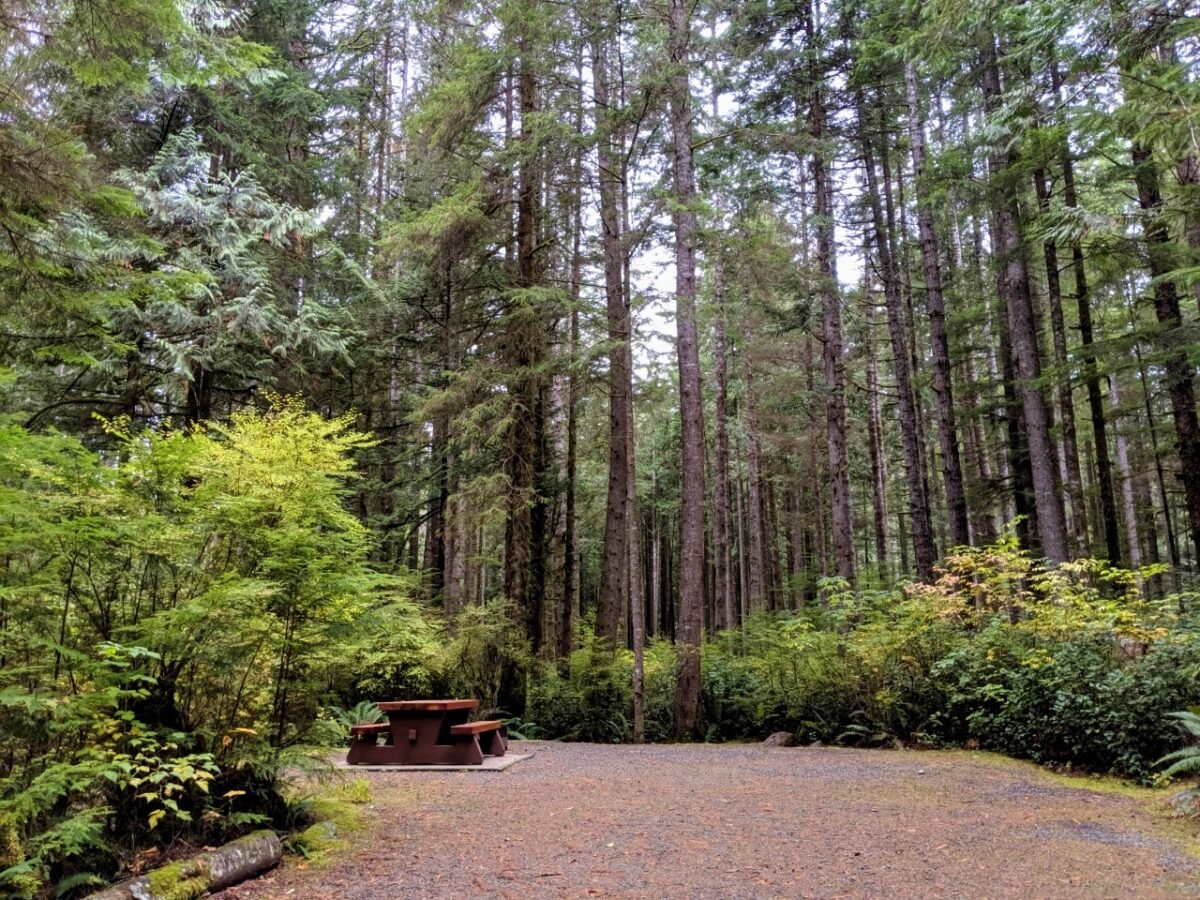
China Beach Campground is located just south of Juan de Fuca’s China Beach Trailhead.
The 78 vehicle accessible campsites are well spaced under a thick coastal forest canopy. 66 spots are available for advance reservation via the BC Parks website. The campground has outhouses and taps with potable (drinking) water but no showers.
The nearest campground with (coin operated) showers is Pacheedaht Campground, located five minutes drive from Port Renfrew.
Most of the 65+ campsites are situated on or just behind a beautiful 2km long sandy beach. Reservations can be made online via the campground website or via phone (250) 647-0090.
Other BC backpacking guides you may find helpful:
The Nootka Trail
The West Coast Trail
The North Coast Trail
The HBC Heritage Trail
Mount Assiniboine Provincial Park
Lake O’Hara, Yoho National Park
The Cape Scott Trail, Vancouver Island
The Iceline Trail, Yoho National Park
Eva Lake, Mount Revelstoke National Park
The Heather Trail, Manning Provincial Park


One half of the Canadian/British couple behind Off Track Travel, Gemma is happiest when hiking on the trail or planning the next big travel adventure. JR and Gemma are currently based in the beautiful Okanagan Valley, British Columbia, Canada. Consider buying us a coffee if you have find any of our guides helpful!
Hi,
thank you soooo much for the detailed explanation of the juan de fuca trail. I will try to plan it for our group, but the tenting and carrying all the items will be a challenge for us .
Best Ute
Hi Ute!
Thanks for letting me know you found the guide helpful – it always makes my day! I hope you saw the note at the top of the post that explains that the Juan de Fuca Trail is closed for the foreseeable future due to the damage. It is being repaired this summer.
My sisters and I are doing this trail mid September this year, and we’re so excited. Thank you for such a detailed list for packing, I had no clue where to start!
Hi DJ,
That’s so awesome to hear! I hope you have a fantastic hike. Happy trails!