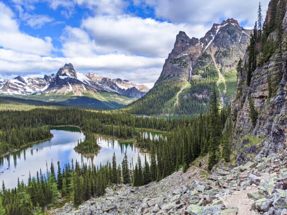
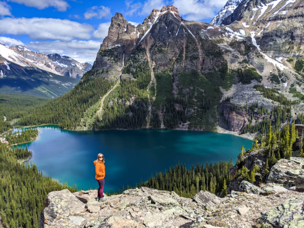
Lake O’Hara is the crown jewel of the Canadian Rockies. With pristine turquoise lakes, cascading waterfalls, soaring mountain peaks, giant glaciers, hanging valleys and more, Lake O’Hara has it all.
All this beauty is accessible via an expansive network of hiking trails and protected by strict daily visitor allowances.

If you only have time to explore just one place in the Canadian Rockies, Lake O’Hara would be an excellent choice. It is necessary, however, to plan ahead.
JR and I have visited Lake O’Hara twice, camping for three nights each time (the allowed maximum). It’s one of my all time favourite places in BC!
We have hiked all of the main trails and alpine routes, including the access road into Lake O’Hara.

This post will tell you everything you need to know about the hiker’s paradise that is Lake O’Hara, including how to get there, how to reserve a campsite, which are the best hiking trails, essential items to bring, how to be safe while exploring and more!
Here’s what to expect:
- Where is Lake O’Hara?
- Why is Lake O’Hara so special?
- The best Lake O’Hara hikes
- How to get to Lake O’Hara
- Staying overnight at Lake O’Hara
- Lake O’Hara general trip planning
This post contains affiliate links. If you make a purchase via one of these links, we may receive a small percentage of the sale.
Backcountry necessities
- Always bring the 10 Essentials
- Know how to stay safe in the backcountry
- Remember to Leave No Trace to help keep the wilderness wild
- Understand how to avoid negative bear encounters
- Trying out backpacking for the first time? Read Backpacking 101
- Check out our packing guide with gear recommendations
- Sign up to our newsletter for a free backpacking checklist
Where is Lake O’Hara?
Lake O’Hara is situated in Yoho National Park in British Columbia, Canada.
This is the traditional lands of the Ktunaxa and Shuswap First Nations as well as the Niitsitapi, Michif Piyii (Métis), Tsuut’ina and Ĩyãħé Nakón mąkóce (Stoney). Quite a few of the mountain peaks retain Stoney names.

The main route into Lake O’Hara is via a 11km long gated unpaved road. Summer access is restricted to authorised vehicles (private vehicles not allowed) and hikers.
The parking lot for the access road is located just off Highway 1 and is approximately 10 minutes drive (14km) east of Field. The village of Lake Louise is 15 minutes drive (19km) in the other direction.
There are five ways to reach Lake O’Hara from the parking lot:
- Visit for the day by bus – Enter a lottery to reserve a seat on the Parks Canada Shuttle Bus
- Visit for the day by foot – Hike 11km and then try to secure a shuttle bus seat out or hike 11km back
- Camp for up to three nights – Reserve a tent site at the Lake O’Hara campground, shuttle bus in and out
- Stay at the Lake O’Hara Lodge – Reserve a cabin or lodge room at this historic lodge situated right on the shores of Lake O’Hara
- Stay at the Elizabeth Parker Hut – Reserve a bed at this rustic backcountry hut near Lake O’Hara, shuttle bus in and out
There is no public transportation to the Lake O’Hara parking lot, so you’ll need your own wheels to get there.

Why is Lake O’Hara so special?
The uniqueness of Lake O’Hara goes beyond the spectacular vistas of alpine lakes, glaciers and mountain peaks.
It’s more than the remote location too, or the chance to see bears, marmots, elk or pikas in their native habitats.
For me, it comes down to two factors – an incredible trail system and strictly controlled access.

Lake O’Hara’s extensive trail system is simply unparalleled in British Columbia, with more than a dozen hiking trails intersecting this wondrous landscape.
Moreover, the trails are incredibly well-constructed and regularly maintained. I have never seen anything quite like it in the backcountry anywhere.
Much credit and thanks is owed to Lawrence Grassi and the other early trail builders as well as the more recent volunteer teams.

The second factor that makes Lake O’Hara so unique is the strictly controlled access.
Restrictions have been in place for many years now, ensuring that Lake O’Hara remains just as beautiful and pristine.
On most summer days, there are only around 200-300 people in the vicinity of the lake, which leaves plenty of room to breathe and enjoy the spectacular views the fullest.

The best Lake O’Hara hikes
Even just from the end of the access road, the views of Lake O’Hara and the surrounding mountains are spectacular. But they get even better once you start hiking!
Lake O’Hara has an incredible trail system featuring easy, moderate and more challenging routes. Many cross and interlink, allowing multiple trails to be combined and covered the same day.
Here’s a taste of some of the amazing hiking trails around Lake O’Hara.

Lake O’Hara Shoreline Trail
Length: 2.8 km circuit
Elevation: minor changes only
Offering an easy introduction to this subalpine paradise, the easy Shoreline Trail circumnavigates Lake O’Hara. The route stays close to the shore the entire way, with fabulous views in almost every direction.
A highlight of the Shoreline Trail is Seven Veils Falls, where there is a couple of different viewpoints to watch the impressive cascades.
If you plan to hike some of the longer trails (such as the Opabin Plateau or Lake Oesa), you will walking sections of the Shoreline Trail to access them.

The Lake O’Hara Alpine Circuit
Length: 11km circuit
Elevation: 1070m gain
The premier Lake O’Hara hiking experience is the Alpine Circuit. Like the Shoreline Trail, it also circles the lake but at a higher elevation.
The Alpine Circuit is a blend of several hiking trails and three alpine routes. For the latter, hikers must be comfortable with traversing and navigating high mountain terrain, with exposed areas.

The Alpine Circuit can be divided into three sections, each individually accessible:
- Wiwaxy Gap and Huber Ledges
- Yukness Ledges
- All Soul’s Alpine Route
Each part of the Alpine Circuit features magnificent yet unique panoramas of the Lake O’Hara area. As mentioned, each section is individually accessible so you don’t necessarily have to hike the entire Alpine Circuit in one go.
With lingering snow and avalanche warnings during our mid-July visit, we were not comfortable with attempting the Alpine Circuit. We finally managed to hike it on our second trip in September 2024 and WOW! It was well worth the wait.
The Alpine Circuit is definitely one of the best hiking experiences in British Columbia. Read our full Alpine Circuit guide for tips, a trail breakdown and difficulty overview.

The Opabin Plateau Circuit via the Opabin Prospect
Length: 5.9 km circuit
Elevation: 250m gain
If you are an intermediate hiker and only have time to hike one area of Lake O’Hara, I would suggest heading to the Opabin Plateau.
Truly wonderful views await from the Opabin Prospect, a rocky cliff above Lake O’Hara (host to Lake O’Hara’s most famous view).
Behind this, a hanging valley reveals gorgeous streams, ponds and lakes. There’s even a glacier to admire at the end.

Being a circuit, there are two ways to approach the Opabin Plateau – East and West. The two trails are joined in the middle by the Opabin Highline Trail.
The West Opabin Trail follows the shore of Mary Lake before steeply climbing up an open talus slope (look for marmots!) The circular detour to the Prospect lookout was easy to find from this direction.
The East Opabin Trail is largely in the forest and features many switchbacks. It’s harder on the knees going down but the ascent is a bit dull, with not much to look at.

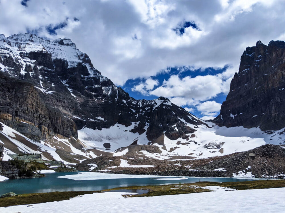
Lake Oesa
Length: 3.2 km circuit
Elevation: 240m gain
The hike to Lake Oesa is a varied one, starting with switchbacks (some with rock steps) leading away from Lake O’Hara. Above the trees, the views start to open up exponentially.
The trail skirts around and occasionally through impressive talus slopes as it steadily climbs towards Lake Oesa, passing by three other small aquamarine lakes on the way (Yukness, Victoria and Lefroy). There are a couple of very short, steep sections.

Lake Oesa sits in an amphitheatre of mountains, at the end of a grassy slope, scattered with giant rock slabs. In mid-July, the vibrant lake was still partially frozen.
Avalanche activity changes the appearance and difficulty of this trail every year. During our mid July, we discovered that lots of large rocks and small trees had recently been swept down the slopes of the mountains above.

Lake McArthur
Length: 8km circuit
Elevation: 310m gain
Pretty alpine meadows, boulder fields and larch trees are all on the agenda for this half-day hike. The finale is Lake McArthur, a glorious sapphire blue-coloured lake backdropped by a line of mountains and a glacier.
We were unable to hike to Lake McArthur on our first Lake O’Hara trip due to snow, but were finally made it on our second.

Lake McArthur is stunning – I found the deep blue colour so mysterious and majestic. We also spotted mountain goats here.
The hike to McArthur is pretty straightforward. The highline route is rocky in places while the lower trail is more of a traditional hiking trail.

Odaray Highline trail to Odaray Grandview
Length: 3.6km return from trailhead
Elevation: 322m elevation gain
Just before McArthur Pass, it is possible to turn onto the Odaray Highline Trail which leads to the Odaray Grandview. This viewpoint truly lives up to its name – honestly, in my opinion it is the best panorama in entire the Lake O’Hara area!
This short side trail has a voluntary program in place to reduce human usage and avoid disturbing wildlife. Only a limited number of hiking groups are should use the trail each day.

On our late September trip, we arrived at the trailhead just after 9am. We were the first group (of four) to sign the logbook. Following Parks Canada’s recommendations, we then waited until 9.30am before starting the trail.
Most of the Highline is a regular hiking trail through the forest (1.3km of 1.8km). The final 500m is a steep, narrow and rocky alpine route that switchbacks up to the Odaray Plateau. There are a couple of places where I used my hands.

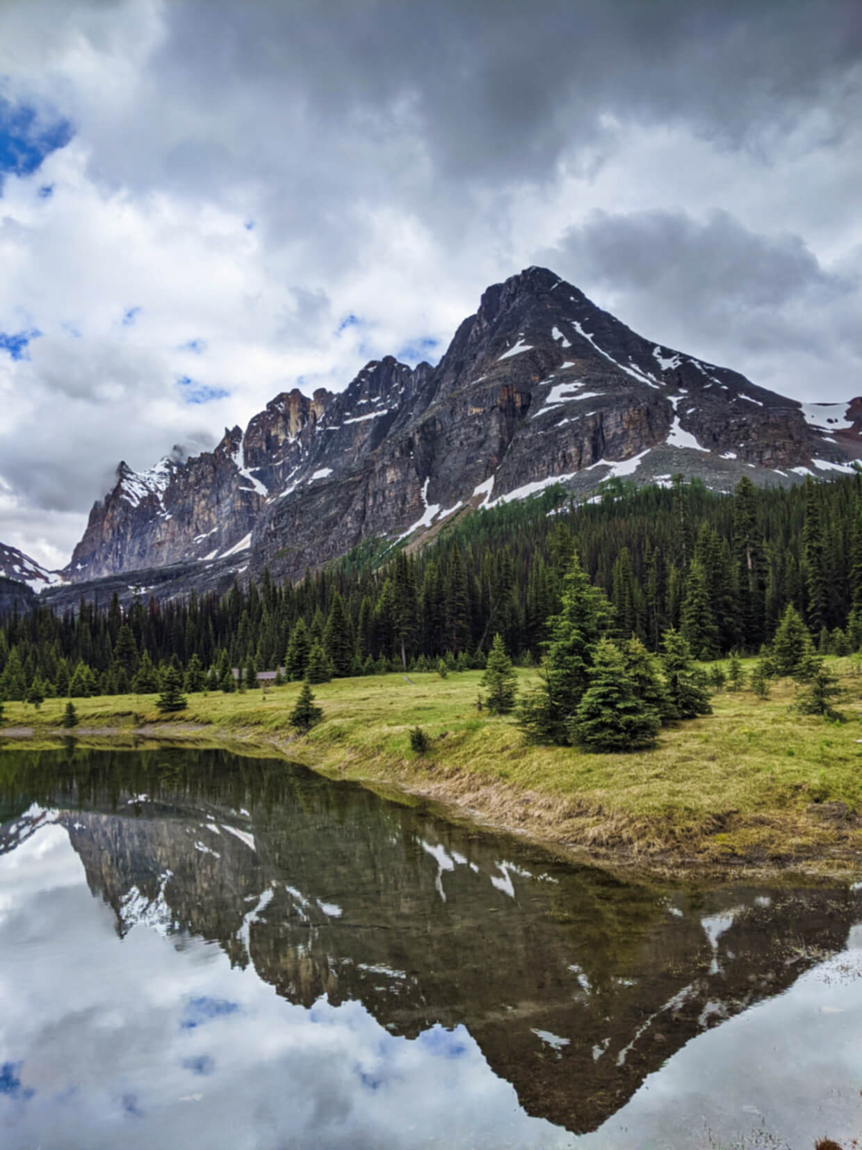
Linda Lake Circuit and Morning Glory Lakes
Length: 3.5 km one way
Elevation: 140m gain
While still beautiful, this circuit is a good option if you have a ‘spare’ day or snow prevents other trail usage. I say this mostly due to the amount of time spent in the forest with limited views.
Starting at the Elizabeth Parker Hut (500m from the Relais Shelter), this trail first takes in a pristine alpine meadow before entering the forest. After a long flat section, the path descends to the very pretty Morning Glory Lakes.
From here, you have three options – return the way you came, complete a circuit back to the Lake O’Hara campground or continue on through the forest to colourful Linda Lake.

How to get to Lake O’Hara
The Lake O’Hara access road can only be used by:
- Lake O’Hara Shuttle bus
- Lake O’Hara Lodge bus
- Visitors travelling on foot, skis or snowshoes
The Lake O’Hara Shuttle Bus
Parks Canada operates a shuttle bus service on the Lake O’Hara road for day visitors, overnight campers and hut users. The buses are classic yellow school buses, painted in Parks Canada colours.

Passengers must have reservations for the inbound journey to Lake O’Hara, with no exceptions. A return bus journey is included with each day reservation, campground reservation and hut reservation.
Day visitors without a reservation can try to secure a seat on outbound services back to the parking lot on a first-come, first serve basis with no guarantees. The fee is $15 and must be paid in cash. More info later.
The Lake O’Hara bus schedule
| Inbound (to Lake O’Hara) | Outgoing (to the parking lot) |
| 8.30am | 9.30am |
| 10.30am | 11.30am |
| 3.30pm* | 2.30pm |
| 5.30pm* | 4.30pm |
| 6.30pm |
During the bus/campground reservation process, you’ll be asked for an inbound bus time preference. The specific ingoing bus journey will be allocated later and confirmed by email.
Arrive at the parking lot bus stop 20 minutes before your allocated departure time. After checking in with the Parks Canada staff, they will give each person two green tokens. The first one will be taken after you have boarded the ingoing bus.

Put the second token in a safe place as you will need it for your outgoing journey. No token – no guaranteed bus ride out. And you’ll have to pay again ($15, cash only).
Inbound buses heading to Lake O’Hara stop first at the campground and then the Le Relais day-use shelter.
Outgoing buses stop at the Le Relais first and then the campground. Staff use radios to communicate how many passengers there are. Day hikers with reservations and campers always have priority when boarding the outgoing bus.
All times mentioned are Mountain Daylight Time (MDT), the same time zone used in Golden, Banff and Calgary. If driving to the Lake O’Hara parking lot from anywhere further west than Golden, remember to consider the time change so you don’t miss the bus!

Day visitor reservation system
In 2026, Parks Canada will again be using a lottery system for Lake O’Hara day-use shuttle bus tickets.
- From 8am MDT 2nd March to 11.59pm 23rd March 2026 visitors can submit an online application using the online Parks Canada Reservation Service
- Each application ($10 nonrefundable fee) allows applicants to select up to 6 different bus days and/or times in preference order
- Random draws will be held after the application window with successful applicants notified (April)
- Draws will be held daily
- Successful applicants will have up to two weeks to confirm their spot
- Any spots not reserved or confirmed later became publicly available to book on a first-come, first served system
Full details can be found on the Parks Canada website.
There is a non-refundable fee of $10 for each application.
If successful, the round trip shuttle bus ticket costs $25.25 per person with a $11.50 online reservation fee.
Overnight campers bus reservation system
At the time of reservation, campers are asked to select a morning or afternoon preference for their inbound shuttle bus.
We reserved our campground spot in January and were assigned our inbound bus journey in April. If you make a campground reservation later on during the year, expect to get a confirmation of your inbound bus within two weeks of your reservation.
Those making a last-minute camping reservation will have their inbound shuttle bus time confirmed by 4pm the day before arrival.
Campers can choose any bus any return bus back to the parking lot and can store gear in the storage shed in the campground until then.
This works in the opposite direction too – campers allocated an early bus can store their gear in the storage shed after arrival and then go hiking.

Bus rules for campers
- Passengers are allowed to bring one large bag or two smaller bags*
- Maximum weight of luggage is 25 kg/55 lbs and length 97 cm/38 inches
- Hard-sided food coolers, hard-sided storage bins, hockey bags items stored in plastic bags, and loose items are not permitted
- Pack bear spray and hiking poles inside bags or carry onto the bus (do not leave in the side pockets of a large backpack)
- Small soft-sided coolers with a maximum volume of 9600 cm3 are OK but count towards the allowance
- Chairs, hammocks, electronic and musical instruments are not permitted on the bus (or the campground)
*We found that the staff were a little loose with this restriction. Most people seemed to have one large backpack or bag and then a smaller bag as a ‘carry on.’ The weight restriction seems more important to avoid physical strain to the bus driver, who lifts the bags when packing the bus.

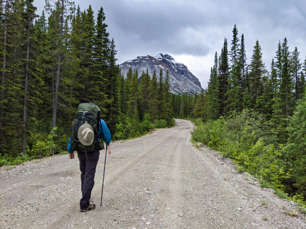
Hiking to Lake O’Hara via the access road
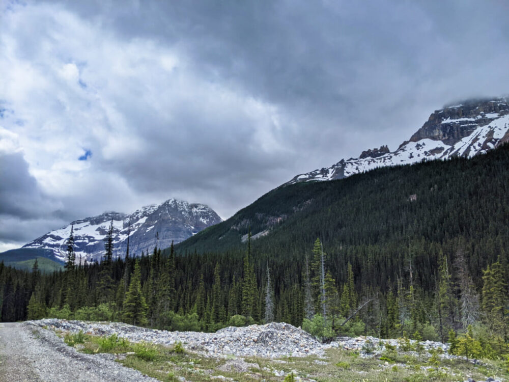
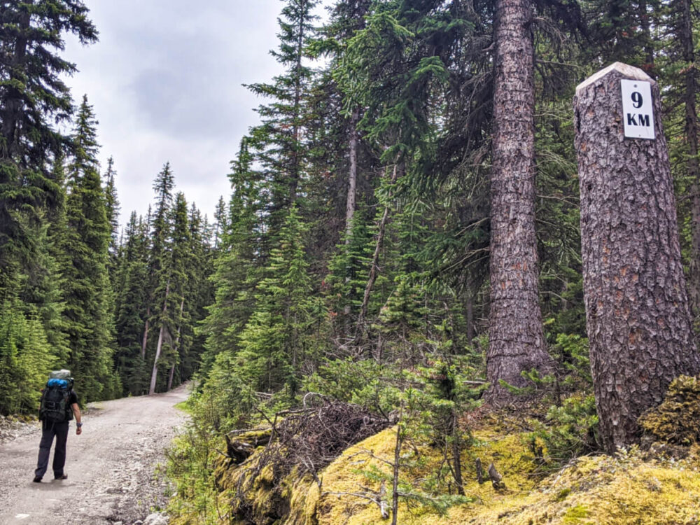
It is possible to hike (or, in winter, ski or snowshoe) the 11km access road to Lake O’Hara. It is a wide, dirt fire road with 430m elevation gain. Bikes are not allowed.
There are kilometre markers along the route so you can count down the distance along the way.
How easy is it to hike the Lake O’Hara access road?
The first half of the hike is fairly flat, with low rolling hills. The second half climbs steadily to the campground (450m total). While the terrain is not challenging, it is the 11km distance that makes the experience tiring.
If you decide to visit Lake O’Hara on a day trip without a bus reservation, you have two options to get back to the parking lot:
- Try your luck with a return bus trip (first come, first serve, more info below)
- Hike the 11km fire road again

We hiked the access road to Lake O’Hara in 2 hours and 20 minutes. It’s important to note that we were carrying our full camping backpacks, as the shuttle bus was not running.
If you’re a regular hiker with a day pack, you can probably complete the one-way trip within 2 hours. Some people choose to trail run it and then change into hiking clothing on arrival at the lake.
Access road description
The hike itself is reasonably scenic, with the wide road offering views of distinctive peaks such as the Watchtower and Cathedral Mountain. Forest lines the path almost the entire way, with glimpses of the adjacent river here and there.
Once at the campground, you’re only a very short walk (5-8 minutes) away from Lake O’Hara.
Close to the shore is the Le Relais Shelter, with picnic tables and outhouses. Cake and other sweet treats are available for purchase (cash only). The famous carrot cake goes on sale twice a day and usually sells out within 30 minutes each time.
Although the overall time (2-3 hours each way) to hike the Lake O’Hara access road may seem reasonable at first glance, be aware that it is still energy sapping.
Lake O’Hara itself is stunning but the experience is even better beyond the lakeshore. The 11km (potentially 22km return) journey just to get there will reduce your ability to see as much as you may like.
Return bus journey for hikers without a reservation
There is the possibility of securing a spot on an outgoing bus service to the parking lot.
As previously mentioned, shuttle bus lottery ‘winners’ and campers always have priority for bus seats.
Wait outside the Le Relais Shelter at the appropriate time and the Parks Canada staff will allocate you a seat if there is space. The cost is $15/person (cash only).
For the best chance to get a spot, try for the 4.30pm service. There are two buses departing at this time.

Staying overnight at Lake O’Hara
There are three options for staying in the Lake O’Hara area overnight:
- Lake O’Hara backcountry campground (cheapest)
- Elizabeth Parker Hut
- Lake O’Hara Lodge (most expensive)
The Abbot Pass Hut was removed in 2022.
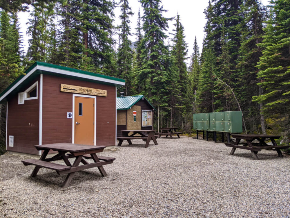
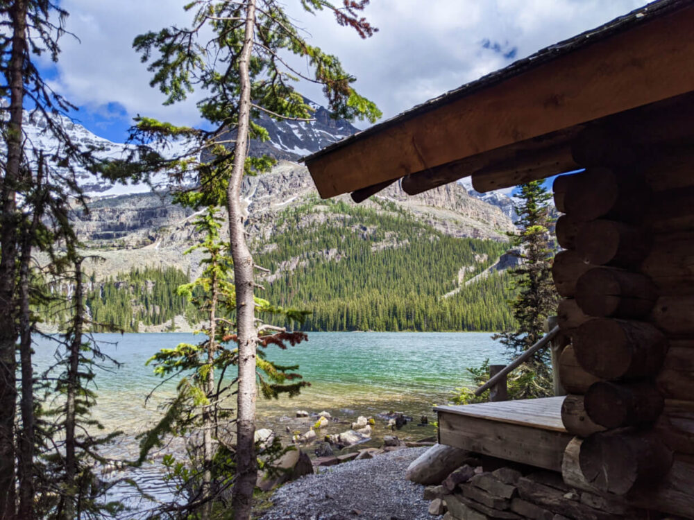
Lake O’Hara backcountry campground
Backcountry meets frontcountry at the Lake O’Hara campground – it’s surprisingly luxurious!
Located approximately 600m from Lake O’Hara itself, the campground is set in a forest with limited views. It only takes 6-8 minutes to walk to the lakeshore, however.
The campground is open mid-June to early October each year. In 2026, the operating dates are 19th June to 4th October.

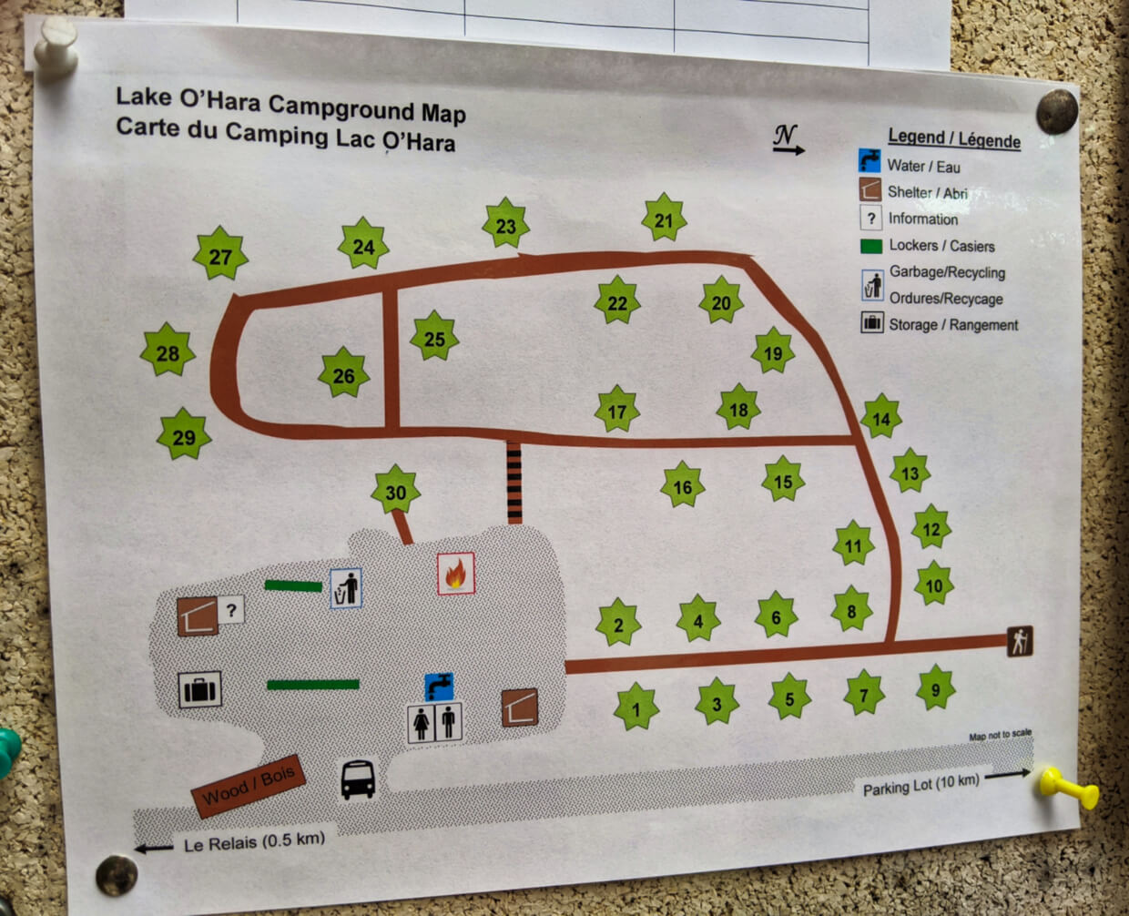
There are 30 semi-private, numbered tent pads set in a forest next to the communal cooking area.
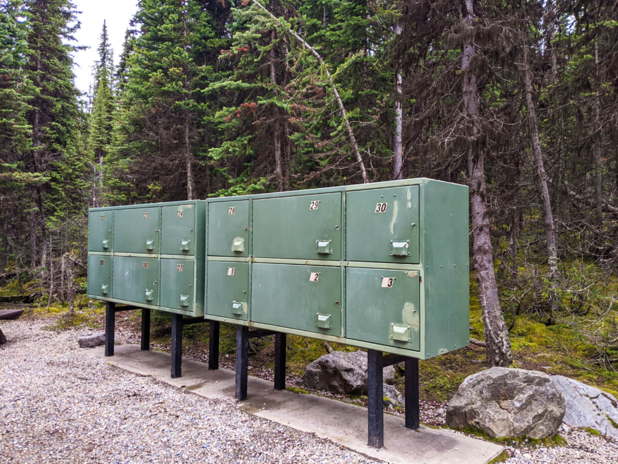
The impressively well-equipped cooking area features outhouses (four total), sinks with running water (!), two cooking shelters with wood stoves, a large communal campfire pit, storage shelter, garbage bins, storage lockers (one for each tent pad) and a number of picnic tables.
The Lake O’Hara campground is well maintained, with daily visitation from Park Canada rangers. There is an information board with check-in information as well as maps and recent trail conditions.
Lake O’Hara camping reservations
Campsites at the Lake O’Hara campground must be reserved in advance via the Parks Canada Reservation System, online or by phone.
All of the available spots are usually snapped up within minutes of the reservation system opening.
Usually, Lake O’Hara campground reservations open in January for the following summer. Check this Parks Canada page for updates.
In 2026, campground reservations were due to open on 22nd January at 8am MST but due to technical issues, the launch will now happen 10th February at 8am MT.
Note the Mountain timezone!

Lake O’Hara camping reservation process and tips
Prior to the reservation launch date, I’d recommend signing up for new Parks Canada account.
I’d also recommend taking the time to get familiar with the reservation platform ahead of the reservation launch. Speed definitely counts.
All users on the reservation website immediately before the launch will be randomly placed into a virtual waiting room.
At 8am, all users will be randomly assigned a place in a virtual queue. Your placing will be displayed on the screen, along with an estimated wait time.

When it is your ‘turn,’ the screen will automatically refresh and you will be able to access the website and make a reservation.
The following instructions are based on pre-reservation launch functionality and are applicable for desktop computers.
- Click the ‘Backcountry’ tab and then ‘Backcountry Zone’ and then ‘Yoho’
- Be careful NOT to click ‘Banff, Kootenay and Yoho Backcountry’ instead
- Choose your arrival dates, party size, number of tent pads and bus preference then click ‘search’
- A map will load below. If a site is available, the diamond next to ‘Lake O’Hara Backcountry Sites’ will display green. Click the diamond
- Scroll down and click ‘Add to Stay’ on the right hand side of the screen
- Then scroll up and under ‘Build My Stay, click the ‘Reserve’ button
- If a site is still available, the next screen will display your reservation details, along with Parks Canada rules. Tick the two boxes and select ‘Confirm reservation details’
- At this point, your campsite should be secured and you’ll have 20 minutes to log in and pay
If the diamond is NOT green, select the calendar view (to the left of the map) and look for alternative availability, signified by green ticks. Click on the ticks and then Scroll down and click ‘Add to Stay’ on the right hand side of the screen.
It is only possible to reserve a maximum of three nights at the Lake O’Hara campground. Consecutive reservations are not permitted.
No luck securing a reservation? Cancellations are occasionally seen, due to the booking window being so far ahead of the actual camping season.

Lake O’Hara campground fees
Online Reservation Fee: $11.50 (non-refundable)
Telephone Reservation Fee: $13.50 (non-refundable)
Backcountry camping fees: $15.00 per person, per night
Bus fees: $25.50 return trip per person
Yoho National Park day pass: $12.25 per adult, per day
All fees are in Canadian dollars and are subject to a 5% Goods and Services Tax (GST).
Since it is only possible to reserve up to three nights at the Lake O’Hara campground, the maximum backcountry camping fee is $45.00 per person ($90 for a couple, for example), plus reservation fees.
If you’re spending more time in Canada’s National Parks, consider getting a Discovery Pass. This covers the daily pass mentioned above.
Choosing a campsite at the Lake O’Hara campground
After arriving at the Lake O’Hara campground, a Parks Canada attendant will give an orientation.
Following the short welcome, the attendant directs campers to find an empty campsite, note the number and then return to get it allocated to their group.
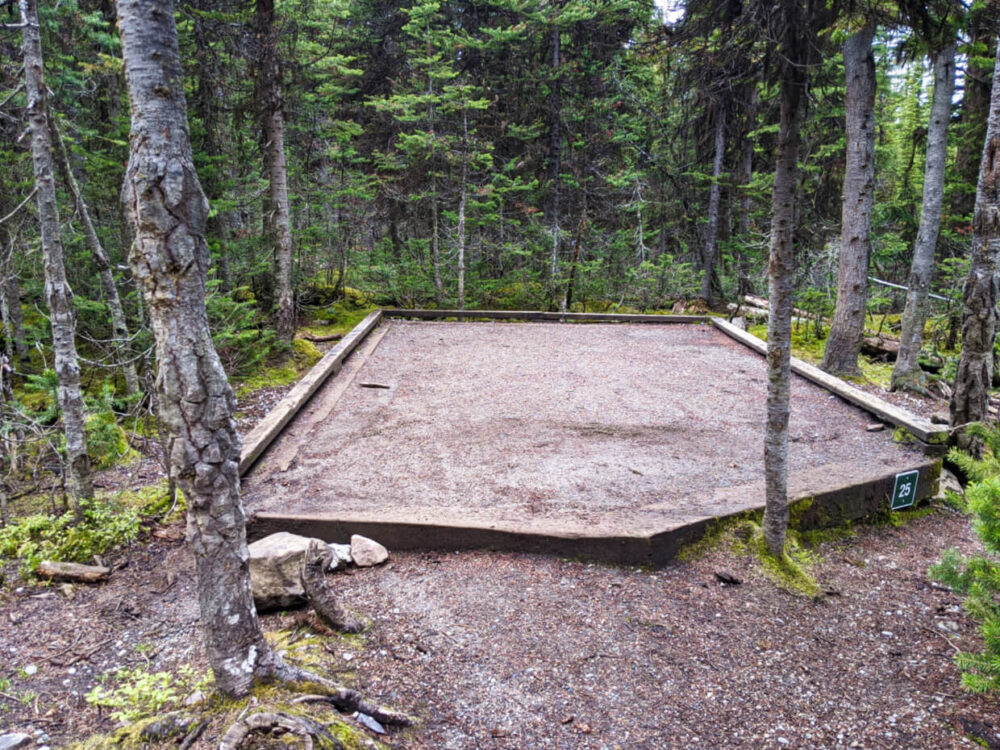
Each campsite has the same style and size of tent pad, which is a rectangle of raised dirt, framed with wood. There is a framed tent number on each pad.
The lay-out of the tenting area is definitely a tale of two halves (see map below).
- Campsites 1 to 14 are situated close to one another, with most of the tent pads being on the same level as the cooking area
- Sites 15 to 29 are on varying levels behind the cooking area and are spaced quite a bit further apart
- Site 30 is an outlier, being located right by the communal campfire pit
We have stayed at sites 23 and 24. Both sites back onto the forest but are still a short walk to the main communal area. The nearest neighbours are a reasonable distance away.
Backcountry huts around Lake O’Hara
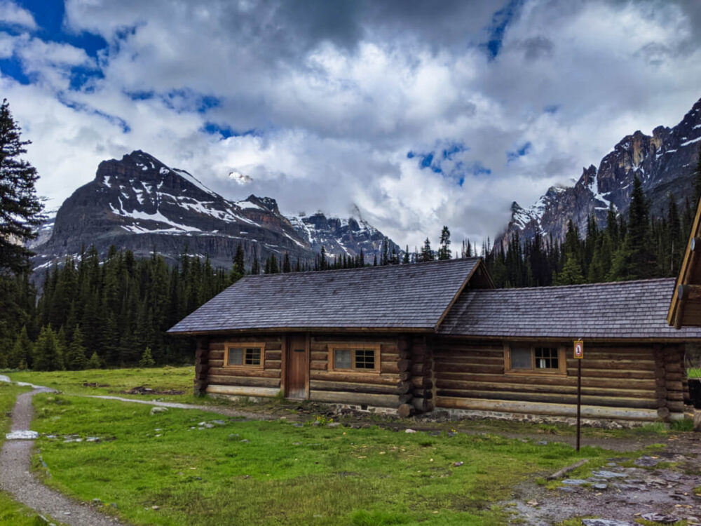
The Elizabeth Parker Hut, operated by the Alpine Club of Canada, is located in a tranquil subalpine meadow just 500m from Lake O’Hara.
Reservations are required and allocated by lottery as it is much in demand. The lottery usually opens in December each year.
The hut has a fully equipped kitchen (propane stove and oven), dining area and two bunk areas for sleeping, as well as a separate sleeping cabin (Wiwaxy).
The Elizabeth Parker Hut runs a communal basis, with individuals and groups reserving bed spots and sharing the space.
Located high above Lake Oesa, right on the Continental Divide itself, the Abbot Pass hut was the second-highest permanent structure in Canada (2926m elevation).
Unfortunately, this historic hut was removed in 2022 due to soil erosion issues.
Lake O’Hara Lodge
Built in 1926, Lake O’Hara Lodge is the only accommodation situated on beautiful Lake O’Hara itself.
As well as eight rooms (with shared bathrooms) in the historic lodge, there are a collection of one-bedroom cabins right on the lakeshore and four larger ‘Guide’ cabins a short walk away.
All meals are included in the nightly accommodation rate, plus afternoon tea and a round trip bus trip on the Lodge’s own shuttle service.
Lake O’Hara Trip Planning Guide
Thinking about planning a trip to Lake O’Hara and need more details? This section is for you! Read on to discover everything I wish I knew before going.
When to visit Lake O’Hara
Lake O’Hara’s summer hiking season is generally considered to coincide with the operating dates of the campground and shuttle bus service.
In 2026, the operating dates are 19th June to 4th October.
The elevation of Lake O’Hara is 2115m, however. Consequently, weather conditions here are remarkably cooler and more changeable than in places closer to sea level.
The winter snowpack varies from year to year, sometimes lingering much later than expected. Snow can come early, or indeed, fall at any time of year.

We first visited Lake O’Hara in mid July 2020. There was more snow than usual that winter and spring was also colder than normal.
The high-elevation trails around Lake O’Hara were still therefore snow covered. Some even had avalanche warnings. Other years, there is no snow on any of the trails by mid July.
If being able to hike all the trails at Lake O’Hara are a priority for you, I’d recommend planning a trip for late July, August or early September.
The rest of September can sometimes be snow-free too but winter conditions sometimes arrive early.
Our second visit to Lake O’Hara was in late September and some of the high elevation trails had a dusting of snow in the morning. Daytime temperatures were pretty low (0-5°C) on cloudy days. Overnight, it was more like -5 to -10°C.
How to navigate the Lake O’Hara area
Thanks to the work of Lawrence Grassi and other trailbuilders and volunteers, the hiking trails around Lake O’Hara are very well-defined.
The trails are regularly maintained in the peak summer season. As well as trailhead signage with distances, there are multiple directional signs at every junction.

Lake O’Hara’s alpine routes are less defined due to the more challenging terrain but are marked with painted blue and yellow symbols.
Cairns (mounds of stones) are also used to indicate the alpine routes. Parks Canada suggests that hikers venturing onto the alpine routes should be “comfortable with route finding.”
- Parks Canada offers this Lake O’Hara PDF topographic map for download. This is best used for planning purposes
- There are similar maps posted in the Le Relais Shelter and Lake O’Hara campground too
- Gem Trek makes a detailed Lake O’Hara topographic map (1:20,000), with trail descriptions on the back
- Our favourite offline navigation app, Organic Maps features all Lake O’Hara trails. We have found the marked routes to be accurate

What to bring to Lake O’Hara
Lake O’Hara is an isolated alpine wilderness area. Visitors need to be self-sufficient and prepared to encounter changeable (and sometimes extreme) weather conditions as well as wildlife and challenging terrain.
As per Parks Canada, hikers need to be responsible for our own safety while exploring Yoho National Park.
It’s also important to follow Leave No Trace ethics. This helps keep Lake O’Hara as wild and beautiful as it is today!
Leave No Trace includes packing out everything you brought in with you (even things like orange peel), not feeding wildlife and staying on designated trails.

The 10 Essentials
Every visitor to Lake O’Hara should be carrying the 10 Essentials with them while hiking. Having these items will help prevent small issues from turning into emergencies. In the worst-case scenario, they can even aid survival.
The 10 Essentials are:
- Insulation (extra clothing for warmth)
- Sun protection (hat, sunglasses, sunscreen)
- Navigation tools (a map, at a minimum)
- Nutrition (food, including snacks and extra in case of delay)
- Hydration (water, method to purify water)
- First aid supplies (to treat minor and major inquiries)
- Firestarter (waterproof matches, lighter)
- Illumination (headlamp)
- Shelter (emergency blanket, bivvy)
Read more about the 10 Essentials, including specific item recommendations.
Appropriate clothing
Besides the 10 Essentials, it is important to be wearing clothing appropriate to changeable alpine conditions.
- Avoid cotton – instead choose poly materials or wool
- Bring a waterproof jacket
- Have at least one warm layer, preferably two
- Wear worn in hiking boots
- Use wool hiking socks
Hiking poles are great for stability. They also help to reduce pressure on the knees when descending. I almost religiously use (and love) Black Diamond’s Distance Carbon Z poles – they are foldable and incredibly lightweight.

Bear safety
Lake O’Hara is home to a wide array of animals, including elk, deer, moose, lynx, marmots, ground squirrels, chipmunks, pikas, mountain goats and more. There’s also a healthy black bear and grizzly bear population in the area.
- Give wildlife space
- Don’t feed animals
- Be careful when eating to make sure you don’t leave any food behind
- Make noise to let wildlife know you’re there
Negative bear encounters are rare, but having bear spray is the ideal ‘just in case’ measure. Carry it in an accessible place (a holster works well) and learn how to use it quickly. More tips in our bear safety guide.
Camping extras
If you’re staying overnight at the Lake O’Hara campground, there are a few more items to pack.
- A lightweight stove – if you’re planning to eat mainly dehydrated or freeze dried meals for dinner, I’d recommend a Jetboil
- A backpacking tent – the tent pads at Lake O’Hara measure approximately 2.7 m x 2.7 m, only one tent is allowed on each pad (max 4 person size). We used a MSR Freelite 2
- A comfortable sleeping mat – with Lake O’Hara being an alpine destination, I’d suggest going for a three season version with a R-value of 2+ (our double Exped is a 3.3)
- A cosy sleeping bag – again, go for something warmer than a ‘summer’ sleeping bag unless you run hot
Each tent pad has use of an allocated locker for safe storage of food and smelly items (such as toiletries).
Parks Canada lists the size of the lockers as 60 cm/24 inches deep, 50/20 high, 60/24 wide. As you can see in the photo below, however, some of the lockers were bigger than others.
There is also running potable water with a sink next to the outhouses – no need to filter water for dinner or coffee here!
Safety information
Lake O’Hara is located is a remote high elevation mountainous area with no phone signal.
Weather conditions can change quickly and often in this area – snow is possible at any time of year.
Be sure to tell someone where you are going and when you’re coming back.
Careful footing is required in many areas on Lake O’Hara’s alpine routes. Take your time. Accidents are more likely to happen when rushing.
Campers and day shuttle users – keep your green Lake O’Hara bus token in a safe place! It is your ticket out.
Final tips
- The Lake O’Hara parking lot has parking for 100+ vehicles, two outhouses and information boards
- Dogs can be walked into Lake O’Hara on a leash, but are not permitted to be in the campground or on the shuttle bus
- It is not possible to cycle the access road to Lake O’Hara
- In the Lake O’Hara core area, there are outhouses at the Le Relais Shelter and campground only
- Be careful not to leave any valuables in your vehicle at the Lake O’Hara parking lot
- There is limited cell phone signal in the parking lot and none at all after travelling approximately 2km along the access road
- Bring cash to buy cakes, tea and other treats at the Le Relais Shelter

Looking for more adventures in the Canadian Rockies?
Hiking the Iceline Trail, Yoho National Park
Complete Hiking Guide to Mount Assiniboine Provincial Park
Exploring Rat’s Nest Cave with Canmore Cave Tours
The Great Divide Trail: Canada’s Most Epic Thru Hike
Hiking the Kananaskis Valley from Mount Engadine Lodge, Alberta
Burgess Shale Fossil Hunting in Walcott Quarry, Yoho National Park
Unique Places to Stay: Charming Inns of Alberta
Climbing Mt Norquay’s Via Ferrata, Banff, Alberta
Check out these recently published articles next
17462

One half of the Canadian/British couple behind Off Track Travel, Gemma is happiest when hiking on the trail or planning the next big travel adventure. JR and Gemma are currently based in the beautiful Okanagan Valley, British Columbia, Canada. Consider buying us a coffee if you have find any of our guides helpful!
We decided to keep our reservation last year too and it was the best decision. Having 20 at the campground the whole time and a few day people it was unreal. 200-300 still isn’t a lot but walking the 22kms was so worth it! Great read and info 🙂
Hi Christine,
2020 was such a great year to visit Lake O’Hara! I’m glad you were able to experience it too. One of the few good things in 2020!
Thank you for this great in-depth information. Is there a location to get information about backpacking in the Lake O’Hara area or is it really strictly set up for day hikes? Besides the Iceland Trail 1-2 night backpacking would you recommend any other areas to backpack 3-4 nights? (Don’t need to if day hikes are just as beautiful and not too crowded.) Looking for options should the attempts at permits doesn’t work out and willing to go Banff/Jasper or beyond. Thanks. Pam
Hi Pam,
Lake O’Hara is really set-up for day hiking only (but seriously, it is truly fantastic day hiking!)
Yoho’s main backpacking area is the Yoho Valley/Little Yoho Valley, where the Iceline Trail is located. There are quite a few options for a 1-2 night route in there, even 3 nights at a push (with day hiking included).
Beyond that, Yoho also has a few routes that are part of the Great Divide Trail. For example, the Ottertail Trail that leads to Goodsir Pass on the border with Kootenay National Park. I haven’t been myself yet but Goodsir Pass is meant to be spectacular. The Ottertail Trail itself isn’t very interesting. If you have two vehicles (or were comfortable hitchhiking/had the funds for a very expensive taxi ride), one option would be start at Paint Pots and then hike into Helmet Falls at the start of the Rockwall Trail and then head to Goodsir Pass and finally Field via the Ottertail Trail. I’ve considered that.
Honestly though, the day hiking opportunities in Yoho are wonderful. As soon as you get away from the parking lot accessible viewpoints (Takakkaw Falls, Natural Bridge etc), it becomes comfortably quiet. The intermediate/difficult trails are not completely deserted of people by any means (weekends will be busier too) – expect to pass other hiking groups but not constantly. You will find solitude.
If you have specific permits in mind and don’t manage to get them, I am a big fan of CampNab for securing cancellations. There are a lot of cancellations.