The Turbine Canyon Backpacking Loop offers a golden opportunity to savour the magnificence of the Canadian Rockies in relative solitude.
Also known as the North/South Kananaskis Pass Loop, this 3-day 41km backpacking adventure showcases breathtaking panoramas of imposing mountains, multiple glaciers, wildflower-studded alpine meadows, deep forested valleys and pristine lakes.

To earn these rewards, however, hikers must contend with multiple steep ascents and descents, several river crossings and a scree slope traverse.
While the first part of the hike is well travelled, the most beautiful section is visited by only a handful of people each day.

Crossing the Continental Divide twice, the route visits both British Columbia and Alberta and overlaps with the Great Divide Trail.
The Turbine Canyon Backpacking Loop is an ideal choice for intermediate or experienced hikers looking for a rewarding (and occasionally demanding) off-the-beaten-path experience. We loved it!

In this post, I’ll share all the essential details you need to know to start planning a North/South Kananaskis Pass backpacking trip.
Here’s the breakdown:
This post includes some affiliate links – if you make a purchase via one of these, we may receive a percentage of the sale.

Backcountry necessities
- Always bring the 10 Essentials
- Know how to stay safe in the backcountry
- Remember to Leave No Trace to help keep the wilderness wild
- Understand how to avoid negative bear encounters
- Trying out backpacking for the first time? Read Backpacking 101
- Check out our packing guide with gear recommendations
- Sign up to our newsletter for a free backpacking checklist

Turbine Canyon Backpacking Loop overview
The Turbine Canyon Backpacking Loop is a 41km multi-day hiking route in the Kananaskis Valley in Alberta, Canada.
The trailhead is located at the North Interlakes day-use area and parking lot, between Upper Kananaskis Lake and Lower Kananaskis Lake.

The Turbine Canyon Backpacking Loop is a combination of multiple trails – the Upper Kananaskis Lake Circuit Trail, the Three Isle Lake Trail, the Maude-Lawson Trail, the Beatty Lake Trail, the South Kananaskis Pass Trail and then the Three Isle Lake Trail and Upper Kananaskis Lake Circuit Trail again.
For simplicity, I describe the route as a loop in the post, but it is more like a balloon on a string, with the ‘string’ part being hiked twice.
This backpacking trip traverses land that is the traditional territory of the Ktunaxa ɁamakɁis, Blackfoot / Niitsítapi ᖹᐟᒧᐧᒣᑯ, Stoney, Métis and Tsuut’ina.

Turbine Canyon Backpacking Loop (North/South Kananaskis Pass): Quick facts
- 41km loop with around 1450m total elevation gain, 1400m loss
- 3 day backpacking trip for most
- Varied trail with easy, moderate and difficult sections
- Can be hiked clockwise or counterclockwise (we think the latter is easier)
- Usually snow-free from mid-July to late September, often earlier
- Reservations are needed for three of the four campgrounds along the route, book three months ahead
- Kananaskis Conservation Pass required – $15/day or $90/annual
- Leashed dogs are allowed

Turbine Canyon Backpacking Loop Hiking Guide
Inspired to hike the Turbine Canyon Backpacking Loop? Read on to discover what you need to know to start planning a backcountry trip.
Location and trailhead details
The Turbine Canyon Backpacking Loop starts and finishes at the North Interlakes Parking Lot in Peter Lougheed Provincial Park in Kananaskis Country, Alberta.
Kananaskis Country is a large multi-use recreation region located on the eastern slopes and foothills of the Canadian Rockies.

This loop hike crosses the Continental Divide into British Columbia at North Kananaskis Pass and then back into Alberta at South Kananaskis Pass (and vice versa).
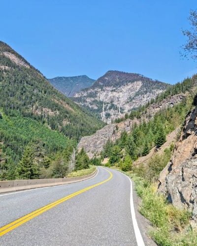
Allow 2 hours to drive from Calgary to the North Interlakes trailhead. The route is entirely paved. The trailhead is situated in a day-use area and has plenty of parking. There are outhouses and trash bins.

Hike breakdown
The Turbine Canyon Backpacking Loop is a varied trail, with a blend of easy, intermediate and challenging sections. Here’s a brief overview so you know what to expect.

North Interlakes parking lot to Forks Campground – 7km
The first part of the Turbine Canyon Loop is very well travelled.
The wide path first skirts the shores of Upper Kananaskis Lake and then starts to climb through the forest.

Above the lake, there are far-reaching views across to the mountains on the other side.
The trail remains wide but becomes very rocky as it traverses the bottom of a talus slope. Follow the signs to the Forks Campground/Three Isle Lake.
Eventually, the trail narrows and returns to the forest. There is a river crossing (with a bridge) shortly afterwards, a great place to stop for a break if you need one.

The next section is mostly flat as the trail winds through the forest, over a few rivers (all with bridges) and even a canyon.
Another talus slope traverse reveals views of the surrounding mountains. A couple more bridges later, the Forks Campground appears. Take advantage of the seating and outhouses!

Forks Campground to Turbine Canyon Campground, 8.1km
Return to the main trail to continue. It looks like the path has been rerouted recently – the Turbine Canyon/Maude Lake junction is after Forks Campground (some maps show the trail going through the campground instead).
Consequently, the next section is a little rough, with a short uphill connection to the old trail next to the river. We found multiple small fossils around this area.

About a kilometre after leaving Forks, the trail starts to climb for real. 400m of elevation is gained over the next 3km.
The narrow path traverses a brushy slope, with intermittent forest cover. There is a series of short switchbacks, some quite steep. The bulk of the elevation gain is completed within 1.5km.

The bulk of the elevation gain is completed within 1.5km, after which the slope gradient mellows and transitions into beautiful wildflower meadows. Tall mountains loom above the trail.
A viewpoint appears, featuring a tarn (Putnik Pond) surrounded by meadows and a long rockwall.

The path descends into this surprisingly lush subalpine landscape as it heads towards Lawson Lake. The shoreline always stays some distance away.
The Turbine Canyon Campground is located at the base of the mountains behind the lake, on the other side of a forest full of grouse (we spotted babies!)

Turbine Canyon Campground to LeRoy Creek – 3.8km
The trail to North Kananaskis Pass via Maude Lake starts at Turbine Canyon Campground (no need to cross Maude Brook again).
A steady climb begins almost immediately, with the path gaining around 100m in just over 1km.

The surrounding landscape is sure to be a good distraction, however, with impressive mountains to the right. This next section of the trail was one of my favourites on the entire loop.
At the top of the climb, Beatty Glacier appears to the left and Maude Lake sparkles turquoise ahead.

The path borders the lake, with the grassy pass visible ahead. Remember to look behind you – the views are simply wonderful.
There is a boundary sign on the pass, signifying the Continental Divide and also the transition into British Columbia. Enjoy the novelty of standing between two provinces!

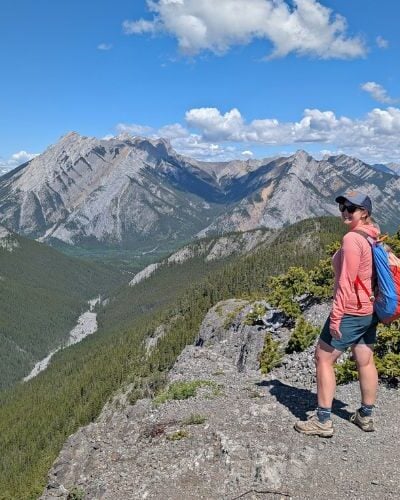
A slight descent on the other side of the pass reveals spectacular panoramas of the breathtaking Royal Group of mountains.
These imposing peaks all rise above 3200m, with Mount King George being the highest at 3411m. It is a sight to behold!

The trail now descends steeply into the valley below. The path consists mostly of small rocks, with some very slippery sections.
Some careful footwork is needed, especially if you don’t like moving over loose rock (like me). I was definitely glad to have a hiking pole.

LeRoy Creek – 2.7km approx
At the bottom of the valley, the trail enters the forest and meanders close to LeRoy Creek. I had heard that the route can be a little overgrown but we didn’t have any issues in late July.
The forest is very thick, however, so we were careful to make noise and try to warn any nearby bears of our presence.

We reached the first river crossing 30 minutes after reaching the valley bottom. The water level was quite low, with the flow split into several channels. A couple of logs provided a makeshift bridge.
The second river crossing is around 30 minutes after the first (4km or so from North Kananaskis Pass).

This crossing was a lot wider and we needed to take our shoes off. I used Teva water sandals. Remember to unclip your backpack when crossing. The river is a good place to stop for lunch.
A short flat section is quickly followed by an unrelenting ascent back up the valley slopes.
About 200m of elevation is gained over just 1km, with the steepest section featuring soft soil and brush. There’s not a lot of shade either so it can be hot in the afternoon.

LeRoy Creek to Beatty Lake – 4.2km
With most of the climb out of the way, the narrow path cuts along the side of the valley before turning east (enjoy a final look at the Royal Group!)
The trail descends a little to Beatty Creek, which is the last chance for muddy-ish water access, and then transitions to a kilometre-long scree slope.

This section is a bit of a slog, especially in the late afternoon. And it would certainly be more challenging in the rain.
It starts with a steady ascent, with the path through the small rocks being pretty boot-beaten. I didn’t find that there was a lot of movement. Around halfway through, the climb becomes steeper and the rocks slightly larger.

As the rough path approaches the top, it becomes very narrow for around 30m with one small section roughly a foot width or less. There is a steep drop-off to the right. I found this part a bit scary. On the upside – amazing views!
The best part about this section is that Beatty Lake is not far away – just 700m (15 minutes) further. The route continues uphill to the lake’s edge and then follows the shoreline to the campground.

Beatty Lake to Interlakes parking lot via Three Isle Lake – 15km
It’s time to return to BC! Warm up along the incline leaving Beatty Lake (80m gain in around 1km).
A wide meadow appears with a lovely easy section of trail. I was surprised to see no wildflowers, however.

South Kananaskis Pass lies just beyond this meadow, with boundary signs to signify the provincial border. The path descends into a forest; expect to see some fallen trees.
It’s not long before Three Mile Lake appears. In late July, the water level was very low. The trail meanders through the forest on the northern shore, with occasional peek-through views.

There are two campground areas to walk through, each with outhouses and seating. Leaving Three Isle Lake behind, the path gets pretty uneven with some rocky sections.
A big reveal awaits just around the corner – you are on the top of a huge headwall overlooking a forested valley. Wow!

As you may guess, the way down is steep. There are some large rock ‘steps’, loose rock sections, and switchbacks. Wooden stairs have been added in the steepest areas.
I found this descent easier than the North Kananaskis Pass. I can imagine it being a very hot ascent in the other direction as there isn’t any shade.

A waterfall cascades close to the trail, accessible from the valley bottom. The final approach to Forks Campground is a mix of forest and open valley with short talus sections and a slow, steady descent next to the river.
Back at Forks, the return journey to the North Interlakes parking area is the same as the outbound route.

Campgrounds
There are four campgrounds situated along the Turbine Canyon Backpacking Loop. Most hikers will stay overnight at two of these campgrounds.
Please note that campfires are only permitted at Forks Campground (when there is no ban in place).

Forks Campground
Distance from North Interlakes trailhead: 7.3km
Reservation required: Yes, via Alberta Parks up to three months in advance
Number of campsites: 20
Facilities: Outhouses, seating/cooking area, food storage lockers, campfire pits
Price: $12 per person, per night
Newly renovated forested campground next to the Upper Kananaskis River. Located close to the trailhead and an ideal overnight destination for new backpackers or families. Most Turbine Canyon Loop hikers will stop here for a break or lunch on the way to other campgrounds.


Turbine Canyon Campground
Distance from North Interlakes trailhead: 15.1km
Reservation required: Yes, via Alberta Parks up to three months in advance
Number of campsites: 15
Facilities: Outhouses, seating/cooking area and food storage lockers
Price: $12 per person, per night
Spacious, newly renovated campground in the forest next to Maude Brook. Plenty of partial mountain views. The campsites are a mix of wood tent platforms and framed gravel pads.
Turbine Canyon is the most popular stop for North/South Kananaskis hikers. We stayed on a Friday night and it was almost empty. There are some day hiking opportunities from the campground.


Beatty Lake Campground
Distance from North Interlakes trailhead: 15km
Reservation required: No
Number of campsites: 4
Facilities: Outhouse, seating/cooking area and food storage lockers
Price: Free
Beatty Lake is a small forested campground in BC’s Height of the Rockies Provincial Park. It operates on a first-come, first-serve system. Site 1 is the premier spot next to the lake.
The lake is excellent for a dip or quick swim. We were alone while camping here on a Saturday night in late July but I have heard it does regularly fill up. There is a resident porcupine so watch your gear!


Three Isle Lake Campground
Distance from North Interlakes trailhead: 10.3km
Reservation required: Yes, via Alberta Parks up to three months in advance
Number of campsites: 16
Facilities: Outhouses, seating/cooking area and food storage lockers
Price: $12 per person, per night
Three Isle Lake is a very popular overnight and weekend camping destination. The campsites are separated into two loops located 500m apart.
Some Turbine Canyon Loop hikers stop here for their first or last night on the trail. Personally, I was happy with the campgrounds we chose.


Fees and permits
A Kananaskis Conservation Pass is required to stop/park in Kananaskis Country. Day passes are $15 and yearly passes $90.
Depending on the length of your intended trip, the yearly pass may be a money-saving option. We usually only visit Kananaskis Country for a few days each year, so we just buy day passes.
The Turbine Canyon Backpacking Loop does not require a specific hiking permit but three of the four campgrounds along the route require Alberta Parks camping permits and reservations.
The nightly camping fee is $12 per person, per night. The reservation fee is $12 per booking. Payment and reservations can be made via the Alberta Parks website up to three months before your arrival date.
Print a copy of your permit and bring it on the hike.
Beatty Lake Campground, situated across the border in British Columbia, is completely free and operates on a first-come, first-serve system.

Itinerary suggestions
There are a few different ways to hike the Turbine Canyon Backpacking Loop.
Three-day counter-clockwise itinerary with Beatty Lake
We hiked the following itinerary:
- Day 1 – North Interlakes Parking Lot to Turbine Canyon (15.1km, 550m elevation gain)
- Day 2 – Turbine Canyon Campground to Beatty Lake (10.9km, 770m elevation gain, similar loss)
- Day 3 – Beatty Lake to North Interlakes Parking Lot (15km, 130m elevation gain, 600m loss)
I felt that this itinerary divided the days and distances well. The middle day featured the most difficult terrain and also the longest time on the trail.
This three-day itinerary only requires one campground reservation – Turbine Canyon. This provides more flexibility when it comes to planning.
Three-day clockwise itinerary with Beatty Lake
- Day 1 – North Interlakes Parking Lot to Beatty Lake (15km, 600m elevation gain, 130m loss)
- Day 2 – Beatty Lake to Turbine Canyon Campground (10.9km, 770m elevation gain, similar loss)
- Day 3 – Turbine Canyon to North Interlakes Parking Lot (15.1km, 550m elevation loss)
This three-day itinerary can be hiked in a clockwise direction as well. I’m glad we didn’t do that as I think I would have found the steep scree slope below Beatty Lake even more difficult (I prefer to go up loose surfaces rather than down!)
Climbing up North Kananaskis Pass in the afternoon heat could prove very challenging.
In hindsight, we were lucky that we did not have hotter weather while traversing the scree slope below Beatty Lake.

Three-day counter-clockwise itinerary with Three Isle Lake
Some hikers choose to stay at Three Isle Lake rather than Beatty Lake, with the resulting itinerary looking like this:
- Day 1 – North Interlakes Parking Lot to Turbine Canyon (15.1km)
- Day 2 – Turbine Canyon to Three Isle Lake (15.6km)
- Day 3 – Three Isle Lake to North Interlakes Parking Lot (10.3km)
This itinerary would be a little more difficult than the one we chose since the second day is longer. Yes, it’s a similar distance to the first day but the terrain is much more challenging.
As mentioned, I found the scree slope below Beatty Lake difficult but it was more manageable for me as I knew that our campground was very close by. I was glad we didn’t have to hike further!
I liked the campground Beatty Lake a lot more than Three Isle Lake. In 2023, water levels at Three Isle were very low and the lake didn’t look as picturesque as it usually would.
Collecting water from Three Isle Lake would have been more time-consuming. I enjoyed swimming (or rather, dipping) in Beatty Lake as well.

Four-day itinerary
Looking for an easier/more relaxed hiking experience and have some extra time spare? Consider this four-day Turbine Canyon loop. This itinerary may also be great for groups getting a late start.
- Day 1 – North Interlakes Parking Lot to Forks (7.3km)
- Day 2 – Forks Campground to Turbine Canyon (7.8km)
- Day 3 – Turbine Canyon Campground to Beatty Lake (10.9km)
- Day 4 – Beatty Lake to North Interlakes Parking Lot (15km)
The extra night between the trailhead and Turbine Canyon offers the opportunity to explore the area around the campground. There are several viewpoints of the canyon as well as a 2.8km one-way hike to the nearby Haig Glacier.
Two-day itinerary
Experienced hikers on a time limit may consider hiking this loop over just two days or even during one very long day (14 to 15 hours).
It seems that the most popular two-day route is a clockwise route as follows:
- Day 1 – North Interlakes Parking Lot to Turbine Canyon Campground
- Day 2 – Turbine Canyon Campground to North Interlakes Parking Lot
Needless, the shorter time frame makes this itinerary more challenging. It is certainly above my physical capabilities!

Difficulty
The North/South Kananaskis Pass Loop is a challenging backpacking adventure. It has a mixture of easy, moderate and difficult sections. There is significant elevation gain and loss with multiple steep ascents/descents.
- The first part of the hike, from the trailhead to Forks Campground is easy, with meandering terrain (small ups and downs)
- Forks Campground to Turbine Canyon is moderate, with increased (yet steady) elevation gain and loss (clockwise direction)
- Turbine Canyon to LeRoy Creek starts with easy subalpine terrain and then transitions into a very steep descent (difficult)
- The section along LeRoy Creek is easy to moderate, with two river crossings
- LeRoy Creek to Beatty Lake is uphill, with two steep sections. The first is brushy with loose rock. The second traverses and ascends a very steep and exposed scree slope (difficult)

- The trail through the scree becomes exceptionally narrow towards the end (very careful footing is required for around 30m). If you are afraid of heights, you may find this section very difficult. The final approach to Beatty Lake is also uphill but less steep
- Beatty Lake to Three Isle Lake is easy, with an established trail across meandering subalpine terrain
- Three Isle Lake to Forks Campground starts with a steep, sometimes rocky, descent. The final section follows the creek and is mostly flat
Inclement weather (snow, heat waves, cold temperatures) can have a significant impact on the difficulty of this trail. There are long, exposed stretches.
As mentioned, there are two river crossings. Water flow will be higher early in the season or after rain. While we were able to rock/log hop the first crossing, we had to take our shoes off for the second and wade across (calf-deep).

Navigation
The eastern side of the Turbine Canyon Loop is relatively well travelled, with an established trail and provincial park signage at every junction. Trail conditions are updated on the Alberta Parks website.
Beyond the boundaries of Peter Lougheed Provincial Park, the trail is a lot less used and is consequently slightly less obvious. There is no signage on the western side of the loop.
Before hiking the route, we’d heard that some trail finding was required between North Kananaskis Pass and Beatty Lake, especially around LeRoy Creek. We didn’t have any issues, however, and I was surprised by how clear the route was.
Cairns marked the river crossings, with some orange tape markings in the trees as well. The river level was not very high during our late July hike and I imagine it may be harder to navigate earlier in the season or after heavy rain.

The climb up from LeRoy Creek towards Beatty Lake is a little brushy and overgrown in places, so it is more difficult to see the route ahead.
It can be hard to see the route across the scree slope just below Beatty Lake from afar, but it becomes clearer as you traverse it. The path travels horizontally through the rock and also straight up.
South Kananaskis Pass (and Beatty Lake) is a popular day hike destination from the busy Three Isle Lake Campground and therefore receives more traffic than its northern equivalent.
We used the Gem Trek Kananaskis Lakes topo map for navigation (thanks Leigh) in combination with the Organic Maps app* (download the maps in advance for offline use) and AllTrails Plus.
AllTrails is not something I usually use while hiking but I signed up for a free trial after hearing that we may need to do some route-finding.
Please note that the Turbine Canyon Backpacking Loop is not marked on any maps specifically with that name as it is a combination of multiple trails (as previously described in this guide).
*The Organic Maps routing does miss a section of the trail from North Kananaskis Pass to LeRoy Creek

The best time to hike
Mid-July to late September is the best time to hike the Turbine Canyon Backpacking Loop. Before and after this period, snow is likely to be present in the higher elevation sections. It varies from year to year, however.
The first part of the route, from the North Interlakes trailhead to Forks, is snow-free for a longer period.

Wildlife
This area of the Rockies is home to a variety of mammals, including grizzly bears.
Negative wildlife encounters in the Rockies are rare. Reduce your risk by:
- Leave No Trace. After eating, make sure you haven’t left any food or wrappers at your location (read more Leave No Trace tips)
- Make noise while hiking. This alerts wildlife to your presence and gives them a chance to avoid you. As a general rule, animals don’t want to be close to humans
- Give wildlife space. If you do see any animals, keep your distance – ideally 100m or more. This offers them an escape route
- Know what to do if a bear approaches you. Always remain calm. Depending on the behaviour of the bear, different techniques are required (read our bear safety post for more info)
- Bring bear spray and store it in an accessible place. An aerosol deterrent made with chilli pepper oil, bear spray is a ‘last resort’ tool intended to be used only when other methods have failed
Reading through the Turbine Canyon Loop reports on AllTrails, many hikers see bear scat but actual bears are not commonly seen.
On a previous trip, our friends Leigh and John heard a bear below the Three Isle Lake headwall.
Creek noise and foliage in this area would make it easy to stumble across a bear without warning. We paid special attention to making noise in this area. We all carried bear spray on this trip in case we became separated.
Though we didn’t have any issues with blackflies or mosquitoes along the trail or in any of the campgrounds, I have heard that they can be bad some years. The only place we did see some was around LeRoy Creek.
There is a resident porcupine at Beatty Lake. We didn’t see it but we were careful to store all of our gear properly (including putting our shoes and hiking poles in our tent).

Safety information
This backpacking trip is located in remote mountainous terrain. The Three Isle/Forks section of the loop is well travelled but you’ll likely be alone for the other sections (we only saw two other groups of hikers and a few trail runners).
To help stay safe, keep the following in mind:
- There is no phone signal in the park or at the trailhead. We carried an InReach device in case of emergencies
- Tell someone where you’re going and when you plan to be back (check out our outdoor safety guide for more tips)
- Due to the elevation, weather conditions can vary and change quickly. Snow is possible at any time of year. Bring extra clothing in case of cold or wet weather
- There may be snow on the trail until early July, sometimes later
- Some sections of the route have very little shade. Bring sun protection (hat, sunscreen)
- Hiked as a three-day trip, this backpacking loop is difficult with some big elevation changes. Depending on your experience, you may find this hike very tiring
- The trail features some very steep terrain, including one scree slope. If you are afraid of heights, this may prove to be very challenging
- There are two river crossings. The speed and height of the water varies with snow melt and recent weather. Remember to unclip your backpack when crossing rivers
- Besides these hazards, it’s also important to be aware of wildlife, particularly bears (see previous section)
- Always purify or filter water before drinking. On this trip, we utilised a gravity hydration bladder system with the MSR Thru-Link In-Line Microfilter
To expand the last point, the best water sources were the Upper Kananaskis River (multiple access points between the trailhead and Forks Campground), Maude Brook (Turbine Canyon Campground), Maude Lake, LeRoy Creek (multiple access points), Beatty Lake and Three Isle Lake.
There is a short downhill side trail to Beatty Creek between LeRoy Creek and Beatty Lake, though water levels were pretty low on our late July hike.

Turbine Canyon Backpacking Loop packing list
The lighter your backpack, the easier (and likely more enjoyable) you’ll find your hike. Of course, you still need to ensure you have everything to be self-sufficient and comfortable. Backpacking is a balance!
Here are all the items we carried on the Turbine Canyon Backpacking Loop (you may find our backpacking gear guide helpful to make your own list):
- Backpack – (Osprey Aura AG 65 for Gemma, Osprey Aether 65 for JR)
- Waterproof pack covers
- Tent (Big Agnes Copper Spur 3)
- Tent footprint
- Homemade sleeping quilt
- Sleeping mat (Exped 3R Duo)
- Hiking boots (we both use Salomon Quest 4D)
- Stove (Jetboil MiniMo)
- Fuel (110g isobutane propane)
- Cup (GSI Infinity Backpacker Mug)
- Bowl/plate (we use a folding bowl)
- Utensils (2 x long spoons like this)
- Cleaning supplies (CampSuds and tiny scrubber)
- Food storage container (we used a dry bag)
- 1.1lb of food/per person/per day
- Clothing
- Pair of hiking poles (Black Diamond Distance Z)
- Water filtration (MSR Thru-Link with Aquatabs as backup)
- Water storage (2 x 2l Osprey bladders)
- Communication device (InReach SE+)
- Headlamp (Petzl Actik headlamp with rechargeable battery)
- First Aid kit with Leukotape for blister prevention
- Sunglasses and sunscreen
- Insect repellent
- Knife (this one)
- Emergency matches
- Tenacious tape (for repairs)
- Toilet paper and hand sanitizer in Ziploc bag
- Camera (Pixel 7 Pro)
- Portable battery charger and phone cable
- Camp/water shoes (I love my Teva sandals)
- Bear spray
- Bear horn
- 5 Dice Game (Yahtzee)
- Printed reservation, permit and map
- Vehicle keys and ID
Essential items
- Hiking poles – This backpacking trip features several very steep descents. Hiking poles can help reduce knee pressure. We used Black Diamond’s Carbon Zs, which are super light and also pack down easily
- Satellite communication device – There is zero phone signal in this region. For emergency purposes, we carried an InReach device
- Bear spray – Grizzly bears are reasonably prevalent in this area. Bear spray is helpful to have as a last resort in the unlikely event you need it. Carry the canister in an accessible place and know how to use it
- Camping permit – Don’t forget to bring a copy of your campground reservation(s)!

Where to stay pre and post-hike
For the ultimate Kananaskis escape, book a stay at the beautiful Mount Engadine Lodge.
This road-accessible wilderness lodge is around an hour’s drive from the North Interlakes trailhead and has all the comforts of civilisation with one of the most impressive backdrops you could ever imagine.
Crosswaters Resort is a cheaper alternative and is about 40 minutes drive away. Situated in Kananaskis Village, this 3-star hotel is very close to the fabulous Kananaskis Nordic Spa.
The nearest campground is the Interlakes Campground, which features 48 unserviced campsites. Mount Sarrail Campground is just up the road and has 44 walk-in tent spots. Both are first come, first serve.
The nearest campground with showers is Boulton Creek Campground (150+ sites). There is a small store as well. We headed here for an ice cream after finishing the trail.

Hiking the Turbine Canyon Backpacking Loop: Our experience
We hiked the Turbine Canyon Backpacking Loop on a weekend in late July 2023 with Leigh from HikeBikeTravel and her husband John.
Our itinerary looked like this:
- Day 1 – North Interlakes parking lot to Turbine Canyon (15.1km, 550m gain, around 6 hours with breaks)
- Day 2 – Turbine Canyon Campground to Beatty Lake (10.9km, 770m gain/similar loss, around 9 hours with breaks)
- Day 3 – Beatty Lake to North Interlakes parking lot (15km, 130m gain/600m loss, 6 hours with breaks)
It was a successful trip (especially considering our water forecast was pretty mixed) though there were some challenging moments.
Day 1 was pretty straightforward until the heavens opened as we ascended the first steep section beyond Forks Campground. It was still warm, however, so we’d already dried off by the time we dropped into the pretty meadows area around Lawson Lake.
We shared the large and wonderfully renovated Turbine Canyon Campground with only one other group (overnight hikers).
The hike to Kananaskis Pass offered a good morning warmup and a feast for the eyes. I loved this section! The view from the top was also incredible. The only bad news? The steep and slippery descent in front of us!
The LeRoy Creek crossings were easier than I feared, though the steep climb afterwards was not.
While the scree slope traverse was also more approachable than I had imagined, I found the final narrow section to be a little vertigo-inducing. My reward was an absolutely beautiful night at Beatty Lake, my favourite campground of the trip.
My highlights from our final day were the meadow at Kananaskis Pass and the view from the headwall just east of Three Isle Lake. Just spectacular.
Final thoughts
Overall, I was impressed by this hiking experience and not just by the views. For one, I couldn’t believe how quiet it was (beyond Forks and Three Isle). And on a weekend too!
I enjoyed how varied the hiking experience was and the amount of difficulty involved. I’m totally guilty of not challenging myself enough and this trail was a good test.

Other backpacking guides you may find helpful:
Mount Assiniboine Provincial Park
Lake O’Hara, Yoho National Park
The Rockwall Trail, Kootenay National Park
Iceline Trail, Yoho National Park
The West Coast Trail, Pacific Rim National Park
Check out these recently published articles next


One half of the Canadian/British couple behind Off Track Travel, Gemma is happiest when hiking on the trail or planning the next big travel adventure. JR and Gemma are currently based in the beautiful Okanagan Valley, British Columbia, Canada. Consider buying us a coffee if you have find any of our guides helpful!
Thanks so much for this detailed write-up! This is a very useful resource, especially the photographs, which give a much more useful description of the trail than just words alone. Just like you I had heard that this was a difficult trail, poorly marked, tough etc. I have hiked very extensively in the Rockes and in BC and it looks similar to most trails there. I’m looking forward to it now!
Chris (Winnipeg).
Hi Chris,
Thanks for the very kind comments! I hope you have a fabulous trip. If you have already extensively in the Rockies already, it is likely you will find the loop pretty straightforward.
Thanks for the excellent breakdown.
One question for you. Is it only 550m elevation gain from Interlakes Parking to Turbin Canyon? All Trails tells me it is more than 1000m.
Thanks!
Hi Pete,
Yes, that is correct. There’s around 250m or so from the Interlakes parking to Forks Campground and then a slightly higher amount between Forks and Turbine.