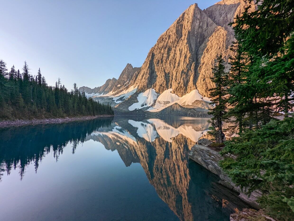
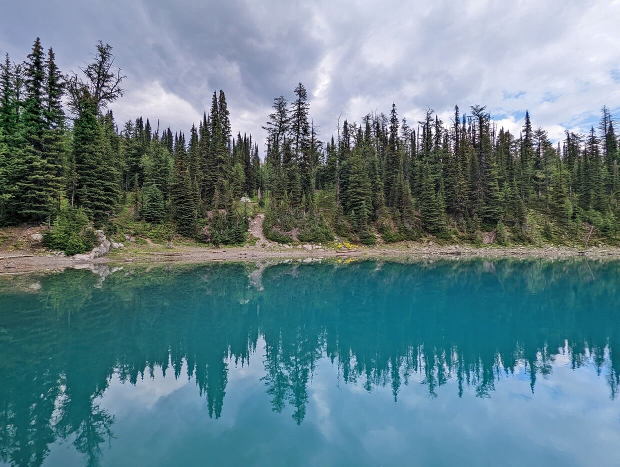
Backdropped by towering peaks and shining bright turquoise in the sun, Floe Lake is one of the most spectacular places in the Canadian Rockies.
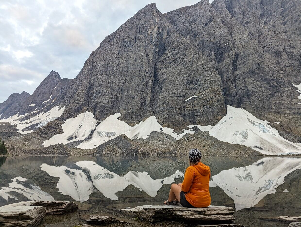
When calm, the lake provides perfect mirror reflections of the surrounding mountains. The views are simply mesmerising!
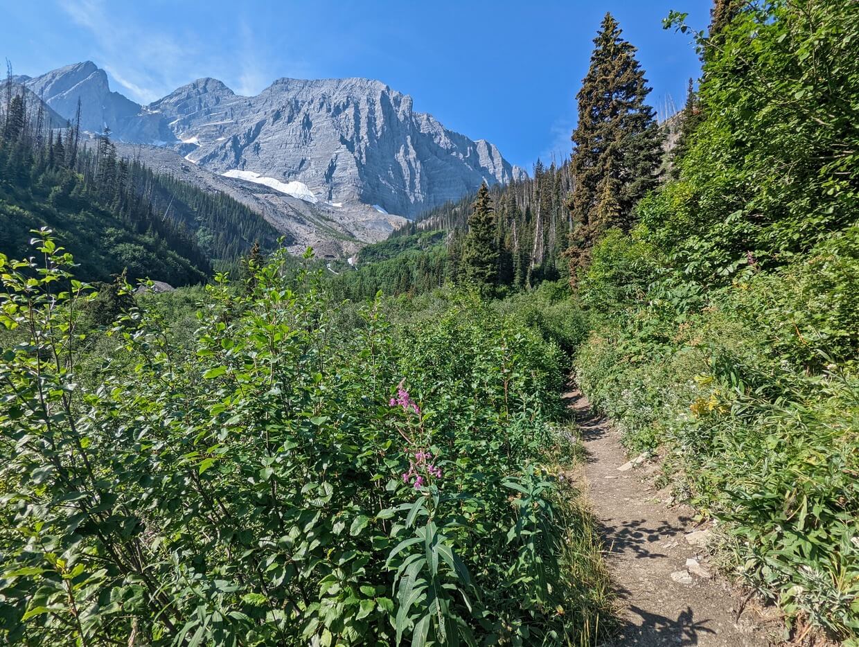
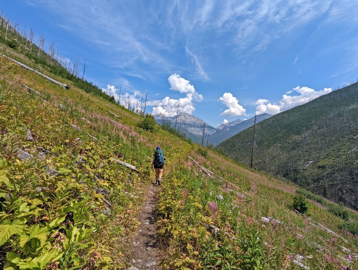
The journey to the lake is a scenic experience as well, with the 10km long Floe Lake Trail offering sweeping vistas of surrounding mountains, a tumbling creek and many wildflowers.
If you’re looking for a challenging but rewarding day hike on the British Columbia side of the Rockies, Floe Lake is an ideal pick. It’s certainly one of my favourites in the province (check out my top BC day hikes)!

This detailed post will help you prepare to hike the Floe Lake Trail. It includes a trail description, safety information, campground reservation tips and more.
The breakdown looks like this:
Floe Lake Trail
Location: Kootenay National Park, British Columbia
Distance: 20km return
Elevation gain: 770m
Hike type: Out and back
Time: 7 to 9 hours with a stop at the lake
Difficulty: Moderate to challenging
Camping: Yes, at national park campground
Fees: National park pass ($12.25/adult)
When to go: Late July to mid September
Dogs: Allowed on leash
Backcountry necessities
- Always bring the 10 Essentials
- Know how to stay safe in the backcountry
- Remember to Leave No Trace to help keep the wilderness wild
- Understand how to avoid negative bear encounters
- Trying out backpacking for the first time? Read Backpacking 101
- Check out our packing guide with gear recommendations
- Sign up to our newsletter for a free backpacking checklist

The Floe Lake Trail
The Floe Lake Trail is a 10km long hiking path in British Columbia, Canada.
The established and well-used route leads to a spectacular glacial lake in Kootenay National Park, the traditional territory of the Ktunaxa and Secwepemc First Nations.
While popular as a 20km day hike, the Floe Lake Trail can also be experienced as an overnight backpacking trip. There is a campground (reservations required) on the shore of the lake.
The Floe Lake Trail is the first (or last) section of the iconic 3-5 day Rockwall Trail. It is also part of the much longer Great Divide Trail which straddles Canada’s Continental Divide.

The beautiful lake isn’t the only reason to hike this trail. In early August, the wildflower meadows come alive with colour. In late September, the larch forests around the lake turn golden.
While the Floe Lake Trail is one of the most popular day hikes in Kootenay National Park, it’s still not extraordinarily busy. There’s still plenty of solitude on the trail and at the lake.
While researching the Floe Lake Trail, you may notice that estimates for the trail distance and elevation gain vary quite a lot (even between Parks Canada’s own sources). Statistics on this page reflect our personal recordings.
Quick Floe Lake facts:
- 20km return distance
- Significant elevation gain on outbound journey (downhill on return)
- Visit as a day hike, overnight trip or longer backpacking adventure
- Usually snow free from late July to early September
- Campground reservations usually open in January (in 2026, January 26th at 8am MT)
- Parks Canada national park pass required
- Leashed dogs are allowed (but please note the lack of shade)

Floe Lake hike experience
Know what to expect on the Floe Lake hike with this trail overview. The return journey is the same route.
Expect the outbound journey to Floe Lake to take 3 to 4 hours, with the return being slightly less. Plan to spend at least an hour at Floe Lake.
Parking lot to valley edge
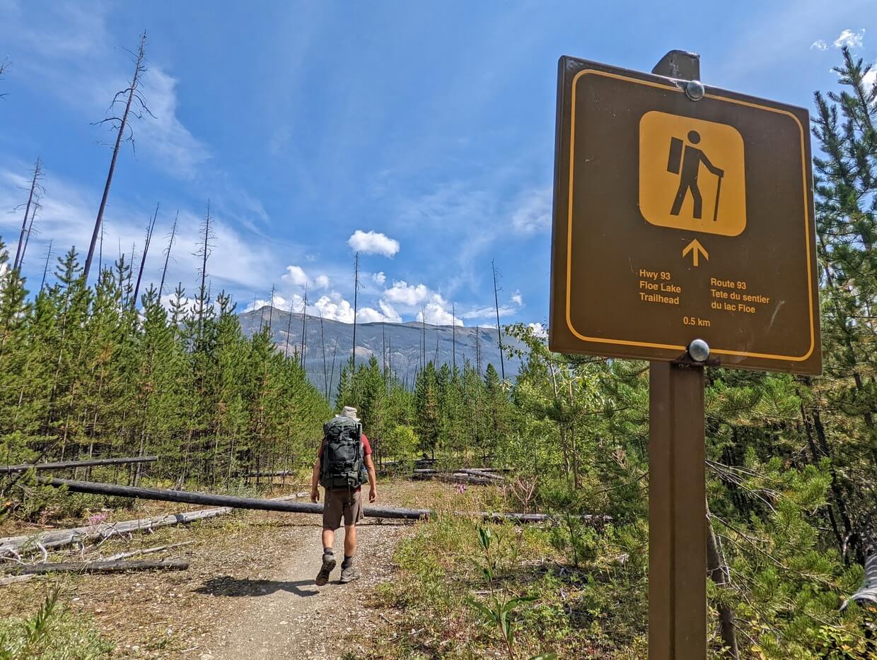
The Floe Lake Trail starts at the Floe Lake parking lot, just off Highway 93.
The first 500m traverses a lightly forested area, with side views of the milky turquoise coloured Vermillion River.
After the first bridge, the trail turns northeast and ever-so-slightly starts to ascend. Trees still line the path here, but being so small, they don’t offer a lot of shade.

The second bridge crosses Floe Creek. The trail starts to climb significantly after this point, with the help of a couple of long switchbacks. It’s now possible to look back and across to the highway.
The final sharp switchback corner sets the direction for the rest of the hike. From this point onwards, you will be following the valley edge all the way to Floe Lake.
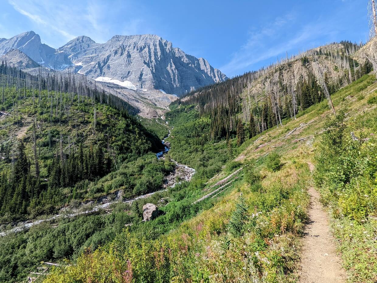
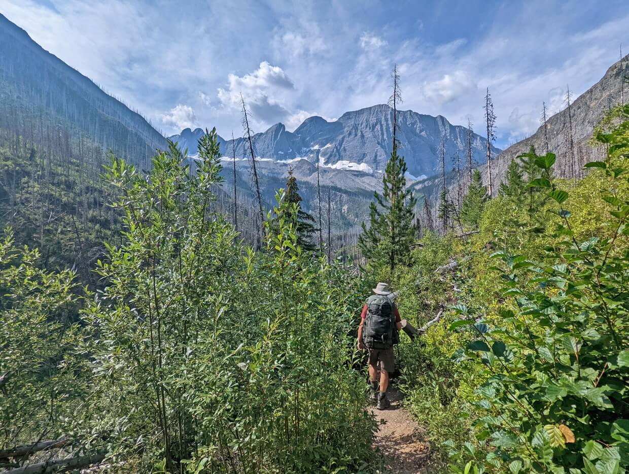
Valley edge to halfway point
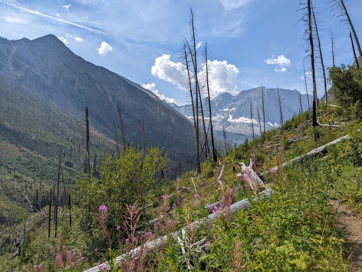
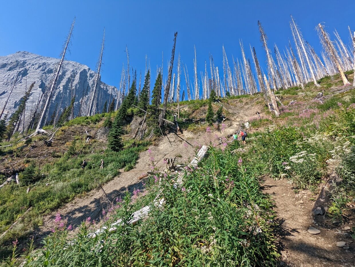
A wildfire swept through this area in 2003, burning most of the surrounding trees. While it may be sad to see blackened tree trunks, the views are a lot more open than they would otherwise have been.
Looking ahead, the mountain range that sits behind Floe Lake is already visible at this stage of the hike. As well as being good for motivation, the view also helps with tracking your progress.
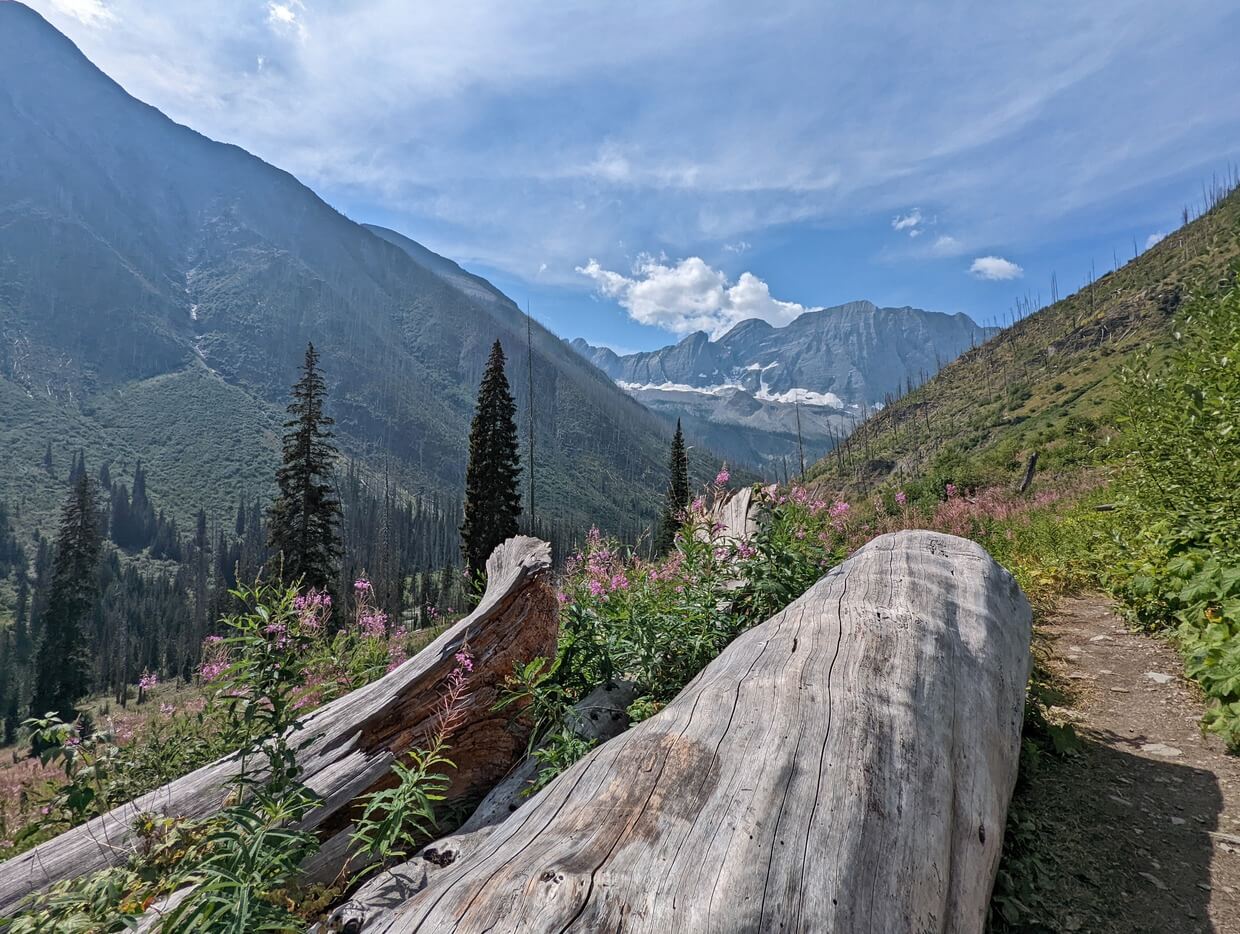
This is the easiest section of the Floe Lake hike. There is a slow overall ascent and some short, steeper ups and downs, but for the most part, it’s a straightforward walk along the side of the valley.
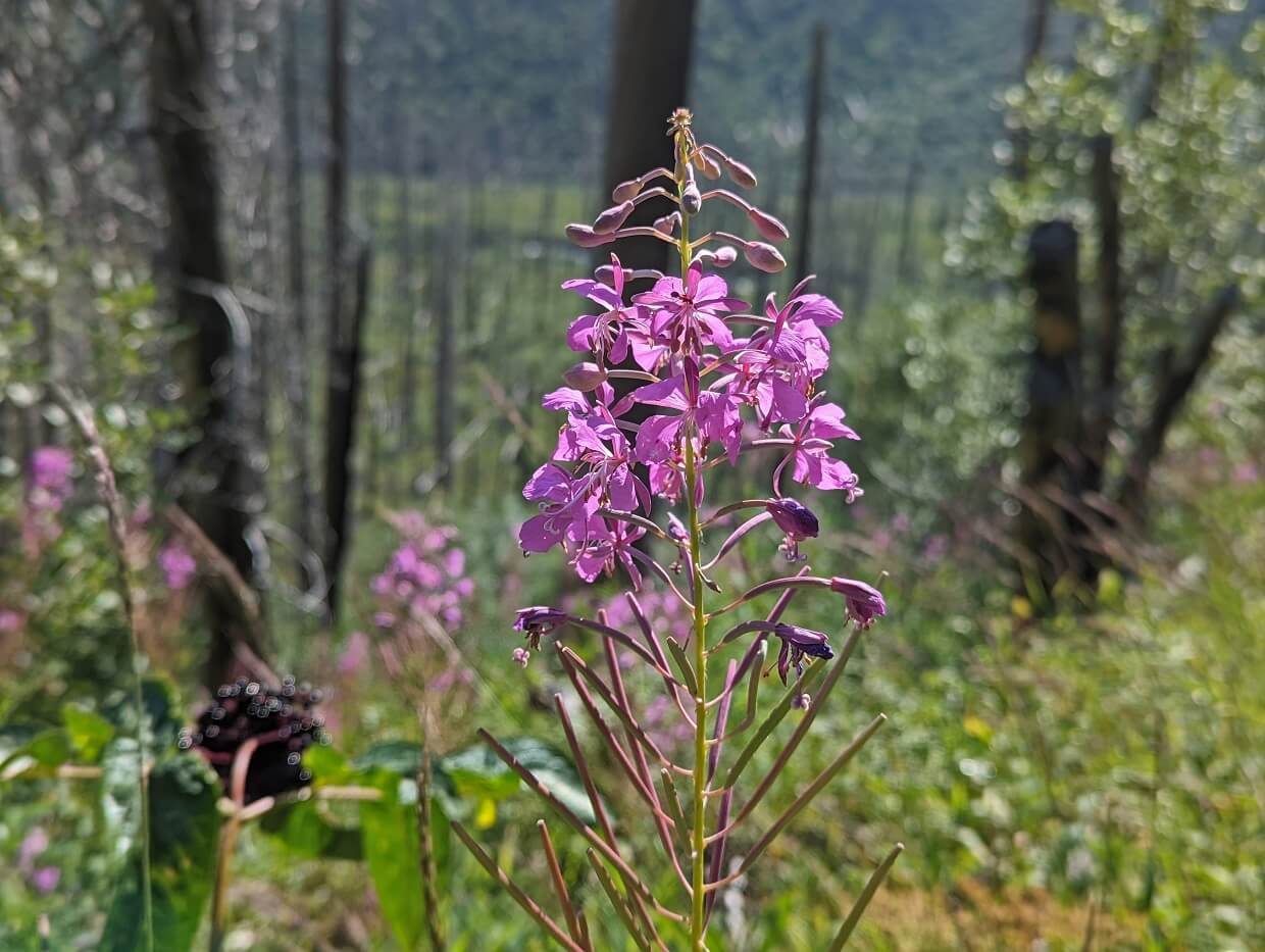
The path is usually lined by bright purple fireweed flowers in late July and August. These provide a stunning pop of colour alongside the blackened trees and bushy green foliage.
Feel like a break? There is a very large log next to the trail around the 5km mark. This is the halfway point of the trail, so an ideal place to stop.
Halfway point to Floe Creek viewpoint
About 800m further from the halfway point, there is a short uphill section, followed by more undulating terrain.
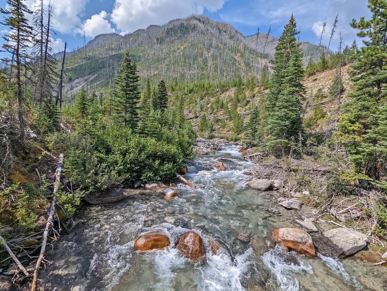
At the 7km mark, the path passes over a seasonal stream. At one point, there was a bridge here. Depending on the flow, you may need to do some careful rock hopping.

There is another stream about 300m afterwards. This one is quite wide and is adorned with avalanche debris. The foliage is quite high and brushy in this area.
A little further on and you’ll get a fabulous view of Floe Creek flowing down from Floe Lake. This will give you a good idea of how much elevation you still have ahead of you!

Floe Creek viewpoint to Floe Lake
After this point, the trail really begins to climb (around the 8km mark). Around 430m of elevation is gained in just 1.8km.
The path becomes steeper as you hike, with the switchbacks becoming longer too. There is almost zero shade here, so be prepared to sweat on hot days!
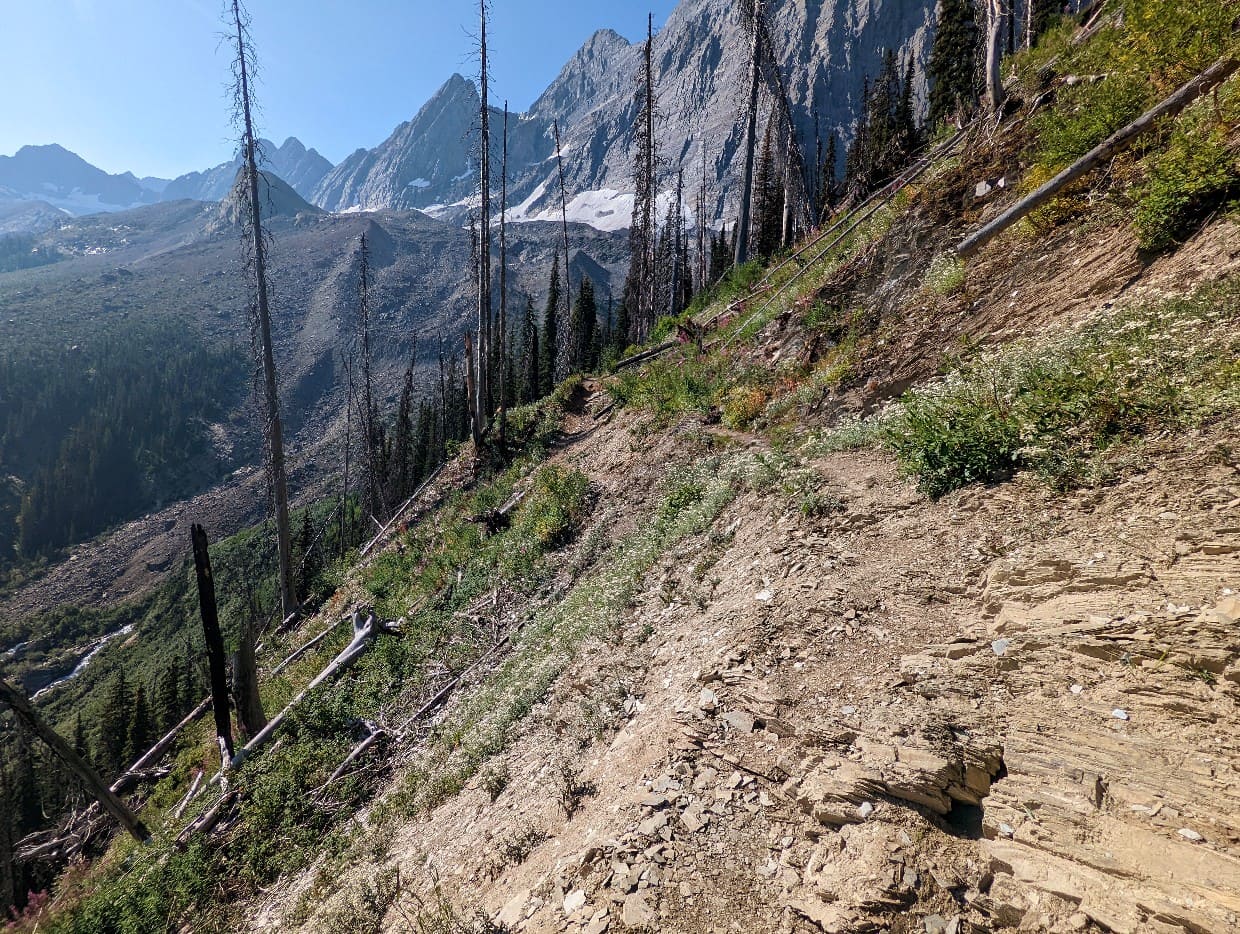
Some of the switchbacks have reasonably steep drop-offs to one side. There is one short rocky section, with loose stones and exposed slabs. Be particularly careful with your footing in wet weather.
The trees start to get greener and more dense as you approach the final uphill section to Floe Lake. When the trail becomes flat and then starts to descend, you know you’re close!

Arriving at Floe Lake
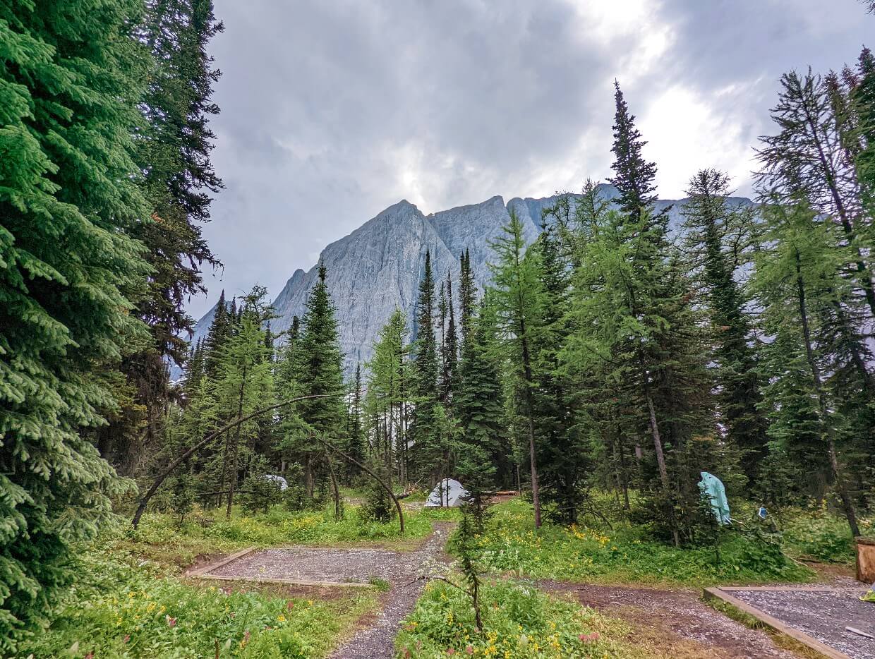
Welcome to Floe Lake! Time to have a break or set up camp.
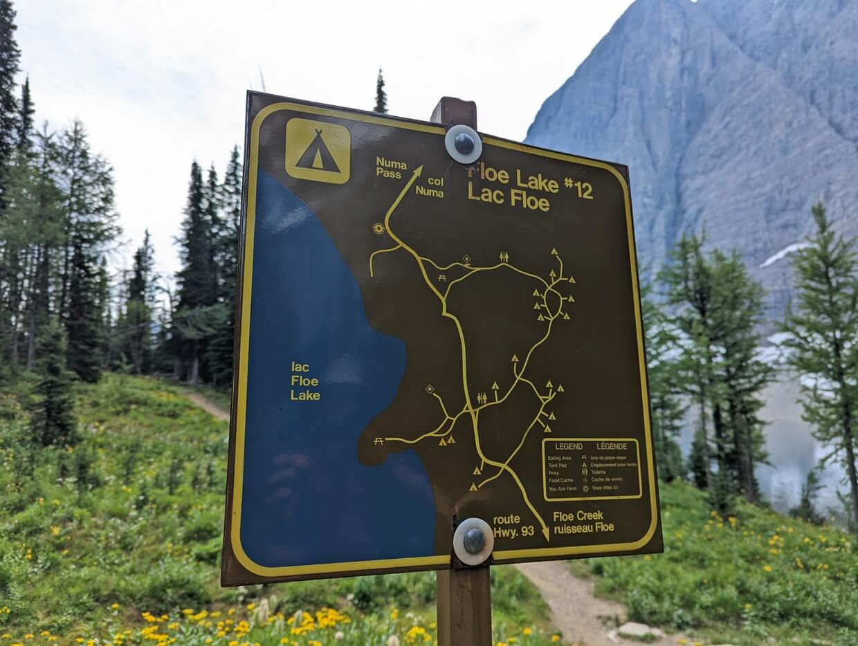
There is only one lakeside campsite at Floe Lake. Take the first left hand turn you see to reach it. Otherwise, continue straight on to the main campground junction.

The first cooking area is to the left (with beach access) while the the main campground entrance is to the right.
Continue straight on to the second cooking area, ranger cabin and more beach access points.
There are many unofficial trails around the Floe Lake campground. Try to stay on the main trails as much as possible to avoid further damage to this area.
When you’re ready to leave, return to the Floe Lake trailhead via the same route.
Numa Pass extension
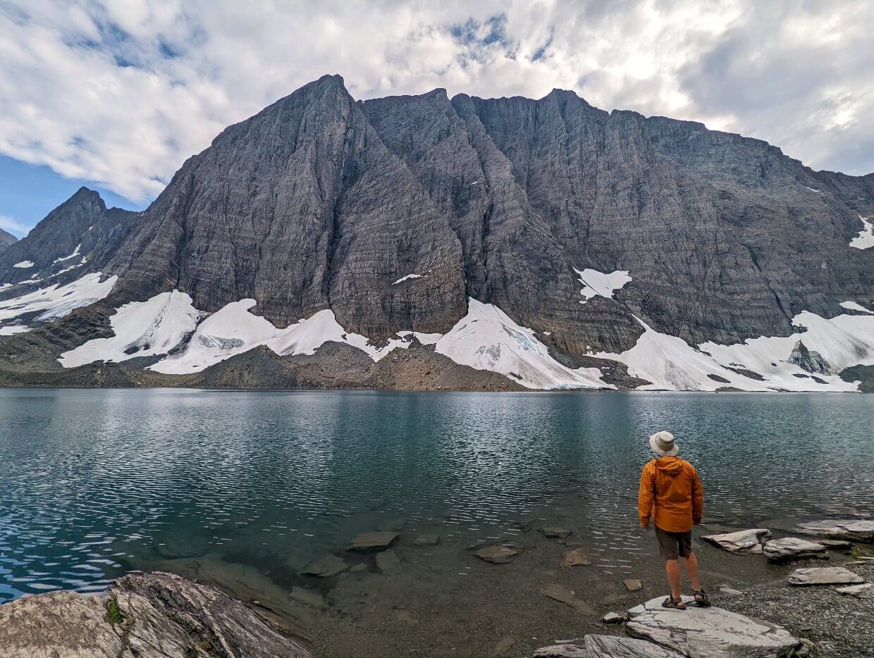
Strong hikers may want to continue beyond Floe Lake to Numa Pass (additional 2.8km one-way, 300m elevation gain).
The views at the pass are truly spectacular. In my opinion, Floe Lake is much more impressive when seen from above. Endless mountain ranges are visible in the other direction.

It’s not necessary to go up all the way to the pass to see Floe Lake from above. There are some great views from the 1.8km mark as well (220m elevation gain).
In mid-August, the meadows surrounding the trail are covered in brightly coloured wildflowers.
Fast forward another month (mid-September) and the larch trees bordering the meadows turn golden before dropping their needles. The area above Floe Lake is one of the best places to see golden larch trees in British Columbia.

Floe Lake Trail hiking guide
Inspired to hike the Floe Lake Trail? In this section, you’ll discover everything you need to know to start planning a trip.
There are affiliate links in the text ahead. If you make a purchase via one of these links, we may receive a small percentage of the sale at no extra cost to you.
Location
The Floe Lake Trail is situated in Kootenay National Park in British Columbia, Canada.
The Floe Lake trailhead is situated just off Highway 93, also known as the Banff Windermere Highway.
The 64km one-way drive from Banff takes around 45 minutes. The town of Radium Hot Springs is 55 minutes away in the other direction, a distance of 72km.
Please note that is not possible to access the Floe Lake trailhead by public transportation – you will need your own vehicle.
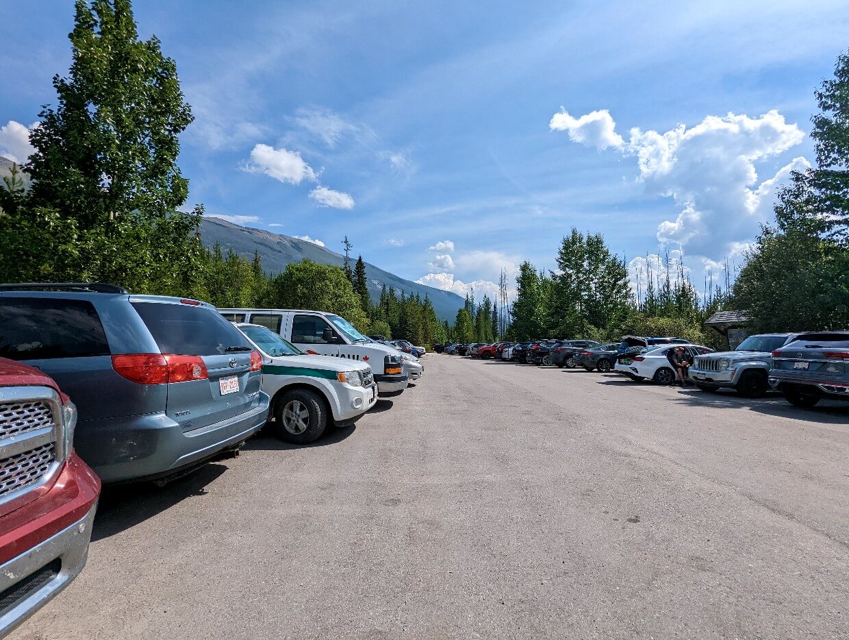
Floe Lake trailhead
The Floe Lake trailhead is well signed from Highway 93. The small parking lot is accessible directly from the highway and is surrounded by trees.
There is parking space for 45-50 cars, though people also park around the entrance on busy days.
This parking area is well used by Floe Lake hikers as well as backpackers starting/finishing the Rockwall Trail and thru-hikers on the Great Divide Trail.
The Hawk Creek trailhead is located on the opposite side of the highway (20km return with 850m elevation gain).
Floe Lake’s parking lot hosts an outhouse, trail signage and garbage bin. There is no water supply, so be sure to bring your own.
When to hike the Floe Lake Trail
The Floe Lake Trail is usually snow-free from late July to early September. The path may be snow-free for a longer period, but it varies from year to year.
During this time of year, temperatures are typically warm during the day (low 20s Celsius, sometimes hotter) and cool at night (2-10°C or less).
It is possible for warm weather to arrive earlier in July and/or continue well into September. Conversely, cold weather may arrive earlier or last longer than usual.
The peak of the wildflower season is usually early to mid August but can start earlier and finish later depending on recent weather conditions.

The larch trees surrounding Floe Lake turn golden in mid to late September.
The exact time of the peak varies from year to year, as per recent weather conditions. For some people, the golden larch period is the best time to visit Floe Lake.
Please note that due to the Floe Lake Trail being located in a mountainous area, weather conditions can fluctuate quickly and often. Snow is possible even in the middle of summer.
Debris can be found on the trail at any time, but this is particularly likely in the early hiking season when annual maintenance hasn’t been completed yet.
The latest trail updates are posted on this Parks Canada page.

Floe Lake Trail difficulty
For experienced hikers, the Floe Lake Trail is a moderately challenging hike involving significant elevation gain on the outbound journey.
Parks Canada rates the Floe Lake Trail to be ‘difficult’ due to this. My own rating is slightly lower due to a large portion of the trail being pretty undulating (small ups and downs).
The Floe Lake Trail is a well established hiking path with no major technical features. The trail is generally quite narrow, requiring hikers to step to the side when meeting others.
There is one steep section, starting from the 8km and continuing to the end. This part of the trail features switchbacks and steep drop-offs to one side. The surface is rocky in places, with some loose stones.
In early season and after wet weather, it may be necessary to cross some small creeks. There may be some snow patches at higher elevations in July.
Hiking challenges
The biggest challenge for most Floe Lake Trail hikers will be the prolonged ascent (and descent on the return journey).
The length of the trail is also a factor, with 20km being reasonably long.
Most hikers should expect to spend 6-8 hours hiking the return distance, with additional time for rest breaks as well as an extended stop at Floe Lake.
The hiking experience is more challenging when backpacking. Carrying a 25-35lb backpack will make any hike harder! Expect to spend more time on the trail, with additional rest stops.
This trail will be more physically difficult in warmer weather. It will also be more challenging if you are not used to hiking long distances with elevation gain. The hike also may take significantly longer.
The Floe Lake Trail is not a route I would recommend for beginner hikers. I would recommend improving your stamina with shorter hikes (10-15km, 400-600m elevation gain) before tackling this one.

Floe Lake fees and permits
While there is no specific fee to hike the Floe Lake Trail itself, there is a requirement to have a valid Park Pass for Kootenay National Park.
IMPORTANT! From 19th June to 7th September 2026, there are no admission fees for national parks and national historic sites operated by Parks Canada (Canada Strong program).
In 2026, park pass fees for Kootenay National park are $12.25/day per adult or $10.75/day for seniors. Youth and children are free.
Park passes for the Canadian Rockies parks are interchangeable. If you have a Park Pass for Banff National Park (or Jasper, Yoho, Glacier, Waterton or Mount Revelstoke), it is also valid in Kootenay National Park.
Be sure to buy a park pass before heading to the Floe Lake Trailhead. It will need to be displayed on your vehicle’s dashboard while parked.

Park passes can be purchased at Parks Canada Visitor Centres (Banff, Lake Louise, Radium Hot Springs, Field) or at park entrance gates (Radium Hot Springs, Banff).
Planning to spend additional time exploring the Rockies before or after hiking the Floe Lake Trail? It may be better value to buy a Discovery Pass rather than a standard park pass.
Discovery Passes are valid for 12 months and include free admission to all national parks in Canada as well as national historic sites.
In 2026, Discovery Passes are $83.50/adult OR $167.50 for a group (up to 7 adults).
Camping at Floe Lake
The Floe Lake campground is one of the most in-demand backcountry campgrounds in the entire Canadian Rockies. And it’s easy to see why!
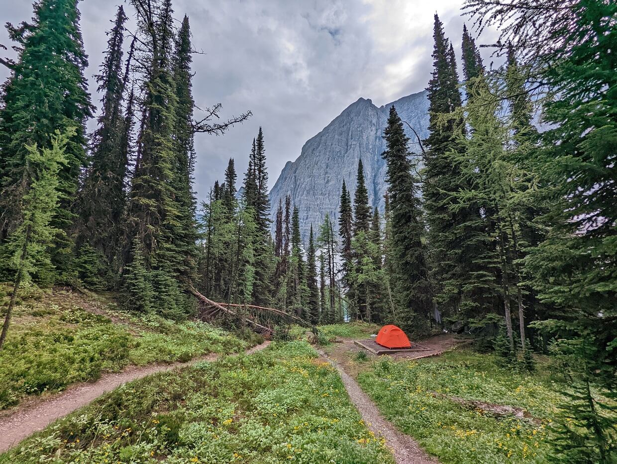
This much-loved campground sits right on the shore of the lake. There is even one tent pad with unobstructed lake views.
Staying overnight at Floe Lake is a special experience. The lake reflections are usually the most impressive at sunset and sunrise.

To camp at Floe Lake, you must hold a valid backcountry permit (Wilderness Pass). Only 18 Wilderness Passes are available each day for the Floe Lake campground.
The cost of a Wilderness Pass is $15.00/night per person.
The easiest way to secure a backcountry permit for the Floe Lake campground is to make a reservation.
Please note that it is only possible to camp at Floe Lake from 10th July onwards due to the possibility of the campground being snowbound.
Floe Lake campground
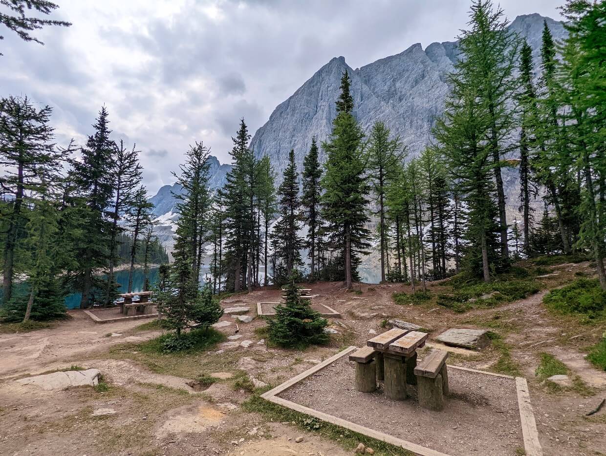
The Floe Lake campground hosts 18 tent pads and two different cooking areas. One of the cooking areas is located right next to the lake.
Each cooking area has a collection of small wooden picnic tables as well as metal food caches.
There is a ranger cabin at the far end of the campground, on the way to Numa Pass.
Campfires are not allowed in the Floe Lake campground.
Floe Lake tent pads
Floe Lake campground’s tent sites are wooden framed dirt pads. Sizing varies but most are around 2.7m x 2.7m. Reservation holders claim sites on a first come, first serve basis on arrival.
The campground’s 18 tent pads are situated in three clusters.
There are two tent pads close to the lake, accessible via the first left turn when approaching Floe Lake from the parking lot. Only one of these tent pads has direct lake views.
The second cluster is accessible via a right-hand turn from the main campground junction. There is an outhouse located here. It is the most well used (and stinkiest) outhouse in the Floe Lake campground.
The third and final cluster can be reached through the second group or via the second cooking area. The largest amount of tent pads can be found here, along with another outhouse. A couple of the tent pads are situated quite far back.
Please note that the Floe Lake campground maps in the actual campground are inaccurate – the food cache and tent pad locations have since moved
Floe Lake reservations
Securing a Floe Lake camping reservation is competitive.
Availability for the Floe Lake campground usually disappears very quickly, within half an hour of the reservation launch.
Backcountry campground reservations for Kootenay National Park usually open in January each year. The exact date is usually announced during the preceding December on this Parks Canada webpage.
Reservations for the 2026 season will open on 26th January at 8am MT.
At this time, availability for the entire summer hiking season (second week of July onwards) opens.
To make a campsite reservation, you must use the Parks Canada Reservation System. It can be accessed online and also by phone (1-877-737-3783).
If you don’t manage to secure a reservation, the only other way to get a Wilderness Pass is to visit the Parks Canada Visitor Centre in Radium on the day of your departure and ask if there is any availability for a same day permit.
Due to the popularity of this campground, I would not rely on this method. Making a reservation is the way to go if you want to camp at Floe Lake.

Floe Lake campground reservation process
On the day of the reservation launch, Parks Canada uses a waiting room system to prevent server overload.
All users loading the website immediately prior to the launch time are held in an online waiting room.
At the launch time, users are then randomly assigned a place in line to access the website. The below instructions are for desktop computers.
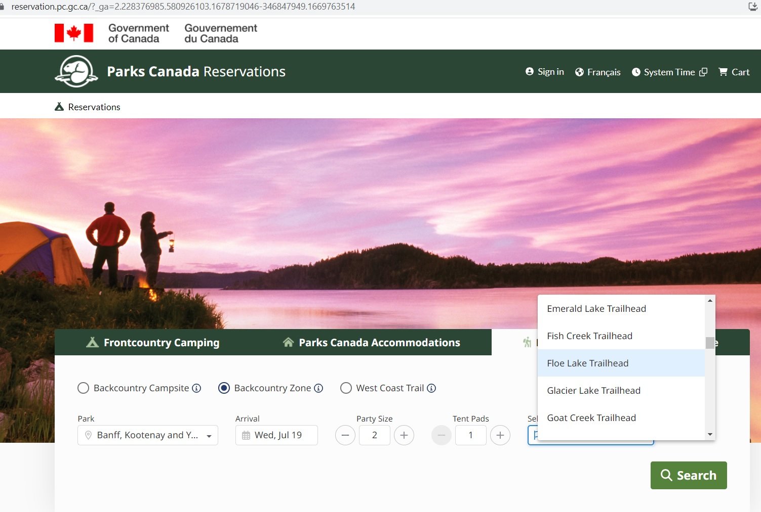
- Once it’s your turn, click the ‘Backcountry‘ tab then select ‘Backcountry Zone‘
- On the drop down list, click ‘Banff, Kootenay and Yoho Backcountry‘
- Choose your preferred arrival date, party size, number of tent pads
- Select the ‘Floe Lake Trailhead‘ on the drop down list
- A map will load below. Click the green* diamond next to the Floe Lake text. Scroll down and click ‘Add to Stay‘ at the bottom of the right hand sidebar
- The screen will refresh and return to the map. If finished, scroll up a little select the green ‘Reserve‘ button on the right hand side
- If the campsites are still available, the next screen will display your reservation details, along with Parks Canada rules. Tick the two boxes and select ‘Confirm reservation details‘
- At this point, your reservation is in the shopping cart and held. As long as you complete payment within 20 minutes, your reservation is secure
- Click ‘Proceed to Checkout‘ to log into your Parks Canada account and pay for the reservation
*Green signifies available. If the diamond is red, it is unavailable. In that situation, click the ‘Calendar’ icon next to the map and look for green ticks indicating availability
Floe Lake campground reservation tips
- Sign up for a Parks Canada account prior to the reservation launch (if you don’t already have one)
- I’d also suggest getting very familiar with the reservation system prior to the launch date, as you’ll need to complete your request as quickly as possible to get a space
- Be flexible with your dates and have multiple options/itineraries ready
- The system allows multiple devices to be used from the same IP address. Each device is issued a different place in line
- Hiking with a group? Enlist other members to help you secure a reservation. The more people trying to reserve, the better chances you have
- Users are able to hold reservations for up to 20 minutes. If they do not complete the booking in that time, the site becomes available again
- Note that the reservation launch date for Floe Lake is the same date for almost all backcountry campsites in Banff, Yoho and Kootenay National Parks – not all users will be trying to book Floe Lake
- And finally….reservations get cancelled all the time. It’s worth regularly checking the Parks Canada reservation system for cancellations
- Alternatively, you can use a service like CampNab to monitor cancellations for you
Floe Lake Trail navigation
The Floe Lake Trail is a well-established and well-used hiking path. Almost the entire trail is a dirt path with only one steep section featuring rock.
The route initially leads northwest from the parking lot and then turn west to follow the edge of a valley almost all the way to Floe Lake.
From quite early on in the hike, you can spot the mountain range that looms above Floe Lake.
Most of the trail is exposed, with very little shade from trees. This means that it is usually straightforward to spot the route ahead. During late summer, large fireweed plants can obscure the path somewhat.
There is brown Parks Canada trail signage in the parking lot and also at Floe Lake campground.
Since the Rockwall Trail is so well established, most hikers will only use the Parks Canada’s Kootenay Trail Guide (printed or PDF versions) for navigation.
We also used the Maps.me app, mostly for checking how much more elevation we had to climb or the distance left.
Organic Maps is an alternative option, maintained by the original creators of Maps.me. It has very similar functionality, accuracy and offline maps feature.
Wildlife
Kootenay National Park is home to a variety of mammals and more than 180 species of birds. Both grizzly and black bears roam this area.
Negative wildlife encounters are rare on the Floe Lake Trail. Parks Canada promotes coexistence and there are a few things hikers can do to help:
- Leave No Trace. After eating, make sure you haven’t left any food or wrappers at your location (read more Leave No Trace tips)
- Make noise while hiking. This alerts wildlife to your presence and gives them a chance to avoid you. As a general rule, animals don’t want to be close to humans
- Give wildlife space. If you do see any animals, keep your distance – ideally 100m or more. This offers them an escape route
- Know what to do if a bear approaches you. Always remain calm. Depending on the behaviour of the bear, different techniques are required (read our bear safety post for more info)
- Bring bear spray and store it in an accessible place. An aerosol deterrent made with chilli pepper oil, bear spray is a ‘last resort’ tool intended to be used only when other methods have failed
Some of the most prevalent creatures on the Floe Lake Trail are mosquitoes, horse flies and deer flies. These are more common during the earlier part of the summer (July to mid/late August, depending on weather conditions). They seem to love hot weather.
Ticks can be present in brushy areas in the campground and along the trail in early summer. Perform a tick check after hiking and know how to remove them properly.
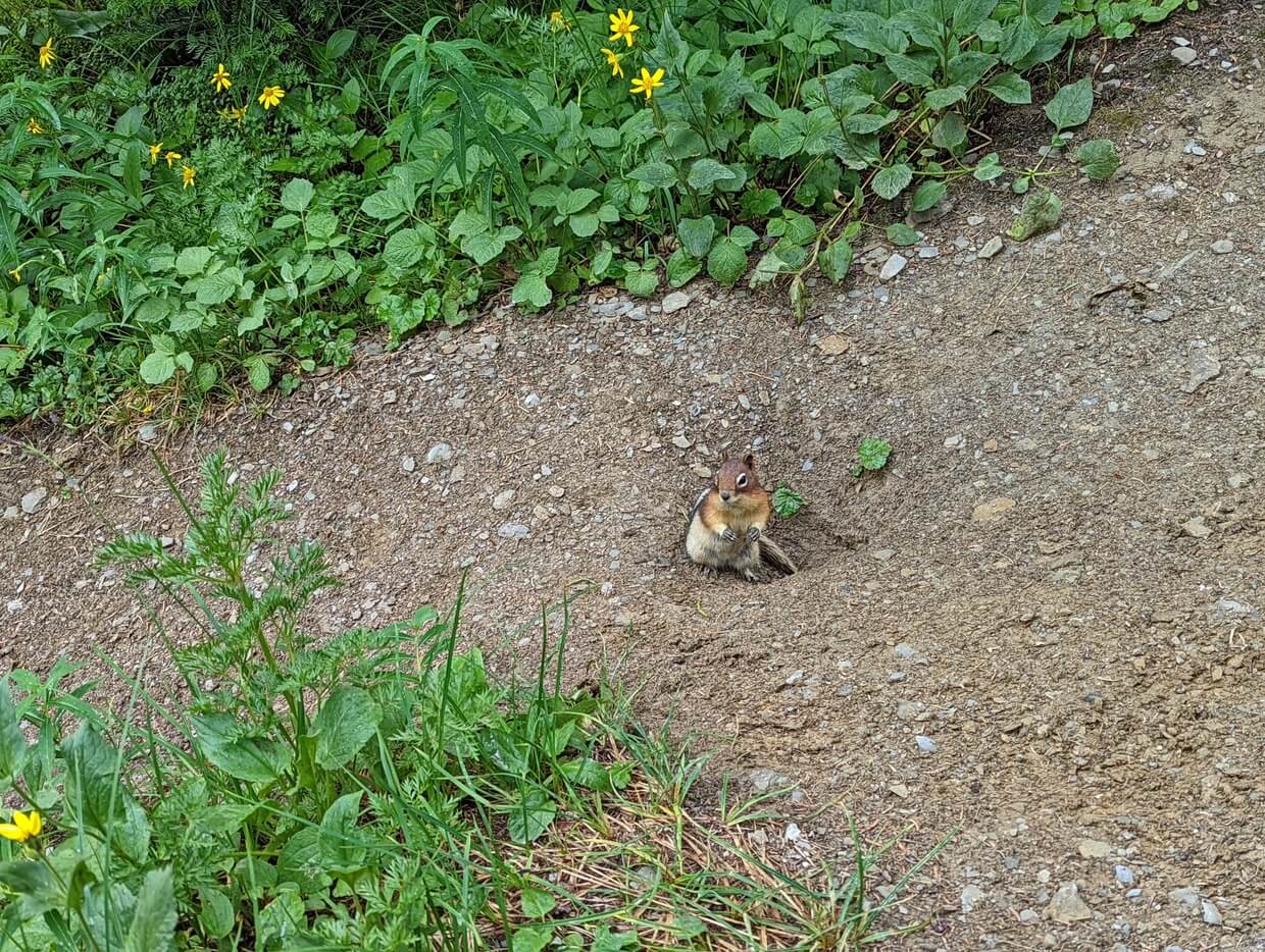
There are many cheeky chipmunks living around the Floe Lake campground area. Be careful not to leave food unattended so you don’t accidentally feed them!
The ocal porcupines apparently love sweaty hiking boots (seriously). When camping at Floe Lake, keep your hiking boots inside your tent.
Safety information
While the Floe Lake Trail may be a well travelled route, it is located in remote mountainous terrain:
- There is no phone signal at the trailhead or on the trail itself. We carried an InReach device in case of emergencies
- Tell someone where you’re going and when you plan to be back (check out our outdoor safety guide for more tips)
- Weather conditions can vary and change quickly. Snow is possible at any time of year. Bring extra clothing in case of cold or wet weather
- There may be snow on the trail until mid July, sometimes even later
- The Floe Lake Trail has almost zero shade. Bring sun protection and plenty of water in warm weather. Start early (pre-9am) if you can
- There is significant elevation gain on this trail. Depending on your fitness and experience, you may find the uphill climb very tiring
- One section of the trail is quite steep (starts around 8km from the parking lot), with some loose rock and narrow sections. Watch your footing and don’t rush, especially in wet weather
- Depending on recent weather, hikers may need to cross some small seasonal creeks. Larger rivers have bridges
- Besides these hazards, it’s also important to be aware of wildlife, particularly bears (see previous section)
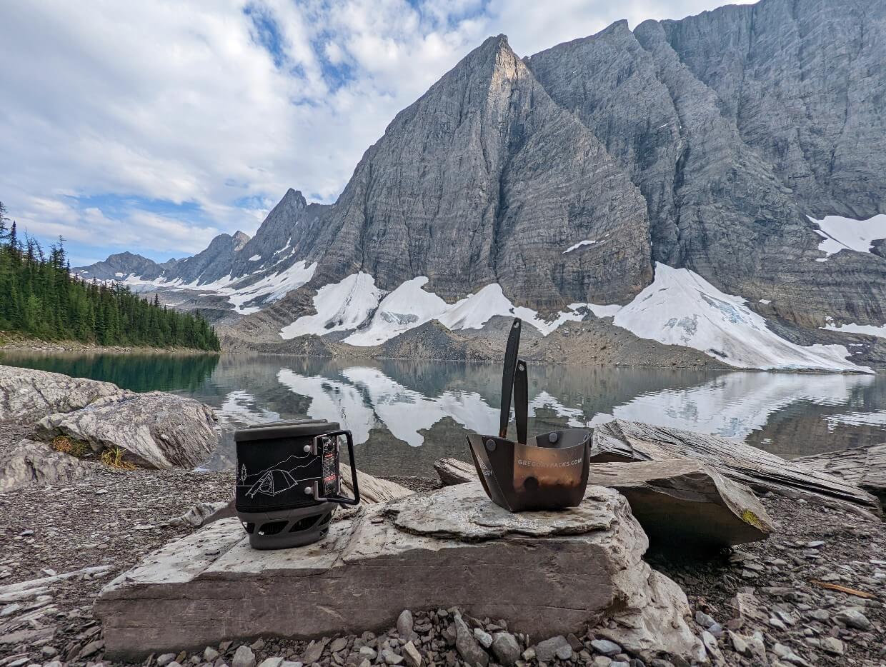
- Always purify or filter water before drinking. On this trip, we utilised a gravity hydration bladder system with the MSR Thru-Link In-Line Microfilter
Water access
Floe Lake itself offers great water availability, with a number of different shoreline access points. Filter or purify the water before drinking to avoid getting sick.
As for the Floe Lake Trail itself, water access is reasonably limited.
The path crosses Vermillion River 450m after leaving the trailhead. The strong flowing Floe Creek is crossed at the 1.8km mark.
After that, there is no reliable access to water until Floe Lake. There are some seasonal creeks that run across the trail, with the largest around the 7km mark. It may not be running throughout the summer.
Though Floe Creek parallels the Floe Lake Trail for most of its length, there is no easy way to reach it.
Please note that the trail route is very exposed (no shade) along its entire length, so it is important to bring plenty of water on warm days.
Start hiking early to avoid hiking uphill during the hottest part of the day. This is especially true if you are hiking with dogs (please bring extra water for them!)
Floe Lake packing list
Visiting Floe Lake a day hike?
Wear a pair of tried and tested hiking shoes/boots, consider bringing a pair of hiking poles and remember to bring the 10 Essentials in your daypack (we use an Osprey Talon 22):
- Extra clothing for the coldest possible conditions during the season you are travelling in
- Sun protection to prevent sunburn and sunstroke (sunscreen, sunglasses, lip balm, sunhat)
- Map to identify your location and how far you need to travel
- Food, including lunch and snacks
- Water, at least 2l during warm weather. Bring a method to purify or filter water
- First Aid supplies in case of injury or sudden illness
- Fire starters, carry matches at a minimum
- Personal light to illuminate your route if delayed (such as a headlamp)
- Repair kit and tools, such as a knife and small amount of duct tape
- Emergency shelter, carry an emergency blanket at a minimum
- Signaling device such as a whistle. There is no cell phone signal in this area. Bring a satellite device for extra security
I would also recommend bear spray, in an easily accessible holster. Toilet paper in a Ziploc bag is also helpful to have as the Floe Lake campground outhouses may have none.
If you are sensitive to flying bugs (mosquitoes, deer flies, horse flies), consider bringing a head net. They are less noticeable on the trail but can be very annoying in warmer weather at Floe Lake itself. I’d also recommend repellent.
Floe Lake backpacking list
Backpackers will need the 10 Essentials plus lightweight camping gear. A pair of camp shoes (I like Teva sandals) are nice to have for hanging around in the campground.
Keep in mind that backpacking is all about balance. Try to keep your pack as light as possible, but with all the items you need to be self sufficient and comfortable in the backcountry.
Check out our Backpacking Gear List Guide for more tips and our Resources page for recommended brands and items. I list all the specific items we brought to Floe Lake in our Rockwall Trail guide.

Where to stay before/after hiking to Floe Lake
Kootenay National Park is an incredible place to spend a couple of days. I would recommend spending at least one night in the park, if your schedule allows.
Stanley Glacier is an incredible destination for a half day hike. Created by the meeting of two glaciers thousands of years ago, Marble Canyon is well worth a short visit. Radium Hot Springs is perfect for a post-hike soak (more Radium activities in our Columbia Valley guide).
Camping options
The closest frontcountry campground to the Floe Lake trailhead is at Marble Canyon (15 minutes drive north).
The sites at Marble Canyon are generally small, though some offer views of the surrounding mountains. There are flush toilets but no showers. Reservations recommended.
An alternative to Marble Canyon is McLeod Meadows (25 minutes south of the Floe Lake trailhead).
The closest frontcountry campground with showers is located at Johnston Canyon in Banff National Park (35 minutes drive north).

Local accommodation options
Treat yourself with a stay at Storm Mountain Lodge and Cabins. This 100 year old property is set on five acres of land in Banff National Park, just 20 minutes drive from the Floe Lake parking lot.
Banff is the closest town to the Floe Lake Trail (45 minutes drive). Our favourite place to stay in downtown Banff is Moose Hotel & Suites.
Situated right on Banff Avenue, Moose Hotel & Suites is just a few minutes from a huge choice of restaurants, cafes and stores. The rooftop hot tub is a much appreciated bonus!

The town of Radium Hot Springs is a little further away (one hour drive) but is generally more affordable for accommodation.
For a stay with a view, check out Radium Chalet. This property is perched on top of a hill behind Radium, providing guests with amazing panoramas of the Purcell Mountains. We have also stayed at Crystal Springs Motel.
Other BC trail guides you may find helpful:
The Iceline Trail, Yoho National Park
Stanley Glacier, Kootenay National Park
Mount Assiniboine Provincial Park
Lake O’Hara, Yoho National Park
Eva Lake, Mount Revelstoke National Park


One half of the Canadian/British couple behind Off Track Travel, Gemma is happiest when hiking on the trail or planning the next big travel adventure. JR and Gemma are currently based in the beautiful Okanagan Valley, British Columbia, Canada. Consider buying us a coffee if you have find any of our guides helpful!
Those merino wool “icebreaker” pants are $182. You must get a great kickback for buying and selling at that price point. Also your posts are way, way too long.
Hi Ali,
The merino wool pants linked on this website are the ones that I personally use and hence that is why I recommend them. There are cheaper versions around, usually with a lower percentage of merino wool. Yes, I receive a small kickback if people purchase items after clicking on a link on our site. It’s not as much as you may think, however.
Sorry that you find the posts too long for your own personal needs. I receive many emails and comments from folks who appreciate the comprehensiveness. But we are all different after all! Happy hiking
This was an incredibly detailed post. Just fantastic. I hiked Floe Lake trail a couple of times over a decade ago when I lived in Calgary. The final time – I was determined to make it to the top of the switchbacks. On the previous attempt my knee knocked out about half-way up. But that final time I made it to the top. I was so proud (and exhausted) I felt I had conquered what I truly wanted. To make it to the top. All these years later, I still regret not pushing that final distance to the lake. I hope one day to make it back (I live in Vancouver) and see the lake. I’ve done Numa Pass from the other trail head and made it to the top.
Thanks again for this memory jab. Beautiful pictures.
Aw thanks so much Chrissy! I’m so glad you found it helpful and enjoyed the memory jab (love that!)
Happy hiking!