As rewarding as it is challenging, the Top of the Giant Trail offers an unique all day hiking experience in northwestern Ontario.
The path ascends the ‘knees’ of the Sleeping Giant, an impressive formation of volcanic rock rising above beautiful Lake Superior, revealing wide ranging vistas of the water as well as the parks’ boreal forest and a deep natural gorge.

These views, in combination with the extended length (22km) and steep uphill climb, makes the Top of the Giant Trail something like a right of passage for Ontario hikers.
For us, hiking the Top of the Giant Trail was a definite highlight of our recent Highway 17 road trip across Ontario. There’s nothing better than a long, scenic hike after several days of driving!

Read on to learn more about the Top of the Giant Trail, including an overview of the hiking experience, parking details, camping info and more.
There’s a FAQ section as well, answering questions like ‘how long does it take to hike the Top of the Giant Trail.‘
Here’s what to expect:
This post includes some affiliate links. If you make a purchase via one of these links, we may receive a small percentage of the sale at no extra cost to you.

Before you hike the Top of the Giant Trail:
- Always bring the 10 Essentials
- Know how to stay safe in the backcountry
- Remember to Leave No Trace to help keep the wilderness wild
- Understand how to avoid negative bear encounters
- Trying out backpacking for the first time? Read Backpacking 101
- Check out our packing guide with gear recommendations
- Sign up to our newsletter for a free backpacking checklist

Top of the Giant Trail, Sleeping Giant Provincial Park
The Top of the Giant Trail is one of the most popular hiking routes in Sleeping Giant Provincial Park, situated at the tip of the Sibley Peninsula near Thunder Bay in northwestern Ontario.
From a distance, Sleeping Giant appears just like a rock figure sleeping peacefully on her back from afar.
In Anishinaabe aadizookaan (traditional storytelling), the Sleeping Giant is known as Nanabosho*, the Spirit of Deep Sea Water. When the secret location of a nearby silver mine was disclosed to white settlers, Nanabosho was turned to stone.
Sleeping Giant Provincial Park is situated on the traditional territory of the Fort William First Nation, who refer to Nanobosho as ‘the first Anishinaabe.’
*also spelled as Nanabozho, Nanabush, Nanabozo
Top of the Giant Trail
Location: Sleeping Giant Provincial Park, Ontario
Distance: 22km return
Elevation gain: 290m
Hike type: Out and back
Time: 6 to 10 hours
Difficulty: Moderate
Camping: Yes
Fees: Day use permit required
Dogs: Permitted on leash
Top of the Giant Trail: Hike Experience
Officially, the Top of the Giant Trail is a 6.6km return route, starting and finishing at the base of the Sleeping Giant cliffs.
Since there is no parking lot here, however, it is necessary to hike additional paths to reach the actual trailhead.

In this post, I will be describing the most popular day hiking route to the Top of the Giant.
The hike starts and finishes at the South Kabeyun Trailhead and is 22km return with 290m elevation gain.
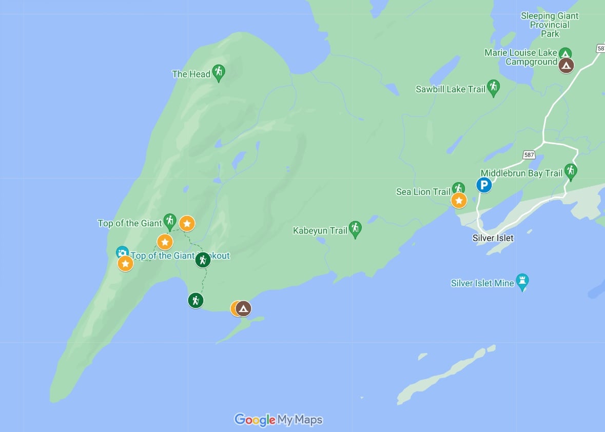
The Top of the Giant Trail, as detailed in this post, is a combination of three different trails (all one-way distances):
- Kabeyun Trail, from South Kabeyun Trailhead to South Talus Lake Trail Junction – 6.8km
- South Talus Lake Trail, from the South Talus Lake Trail Junction to the Top of the Giant Trail Junction – 0.8km
- Top of the Giant Trail, from the Top of the Giant Trail Junction to the Gorge Lookout – 3.3km
While there are other (longer) ways to access the Top of the Giant Trail, the above routing is the most direct. If you’re a keen backpacker, there are numerous multi-day itineraries possible.

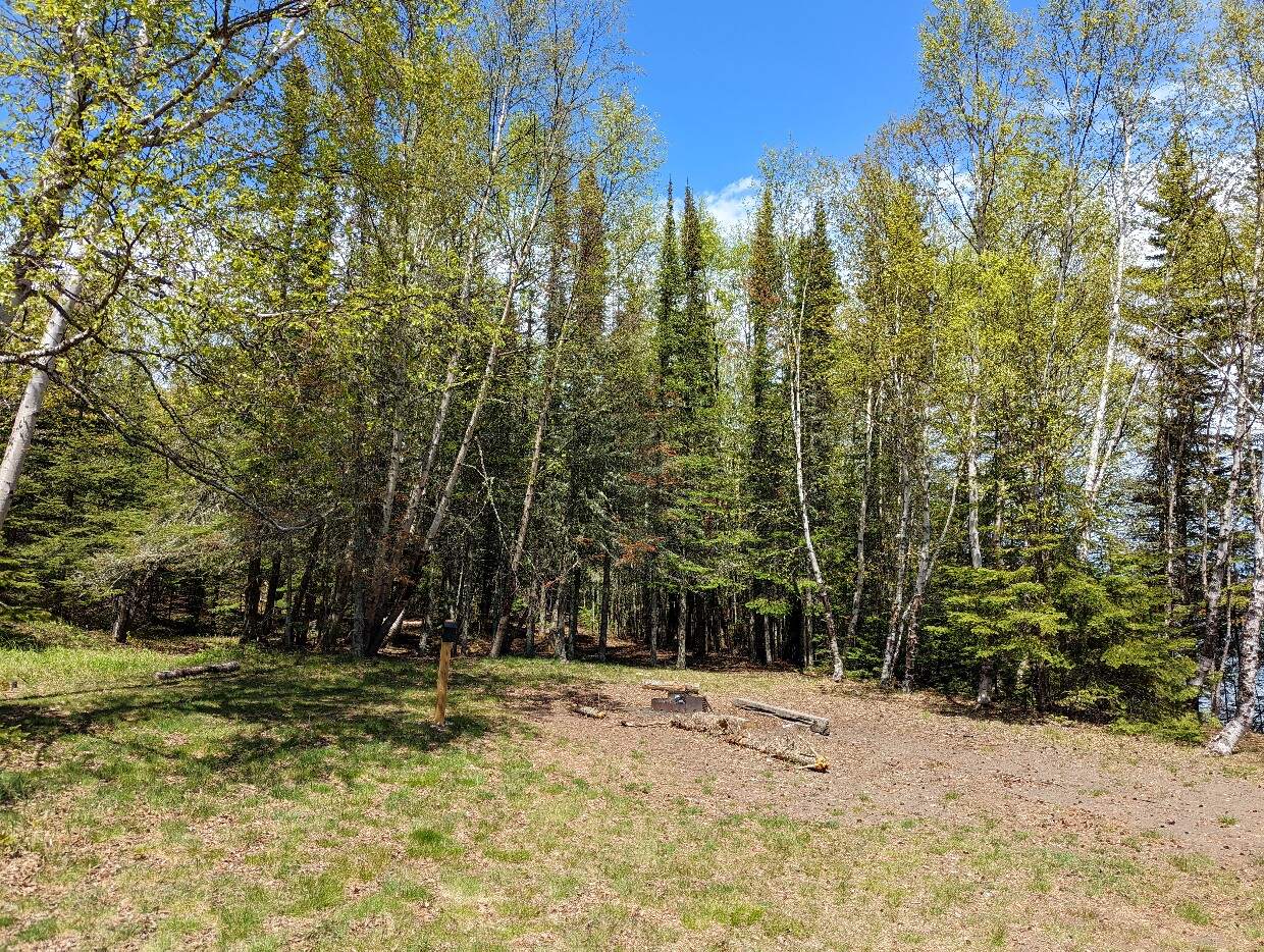
South Kabeyun Trailhead to Tee Harbour
The journey begins at South Kabeyun Trailhead, where wooden signage marks the start of the route and indicates the distances ahead.
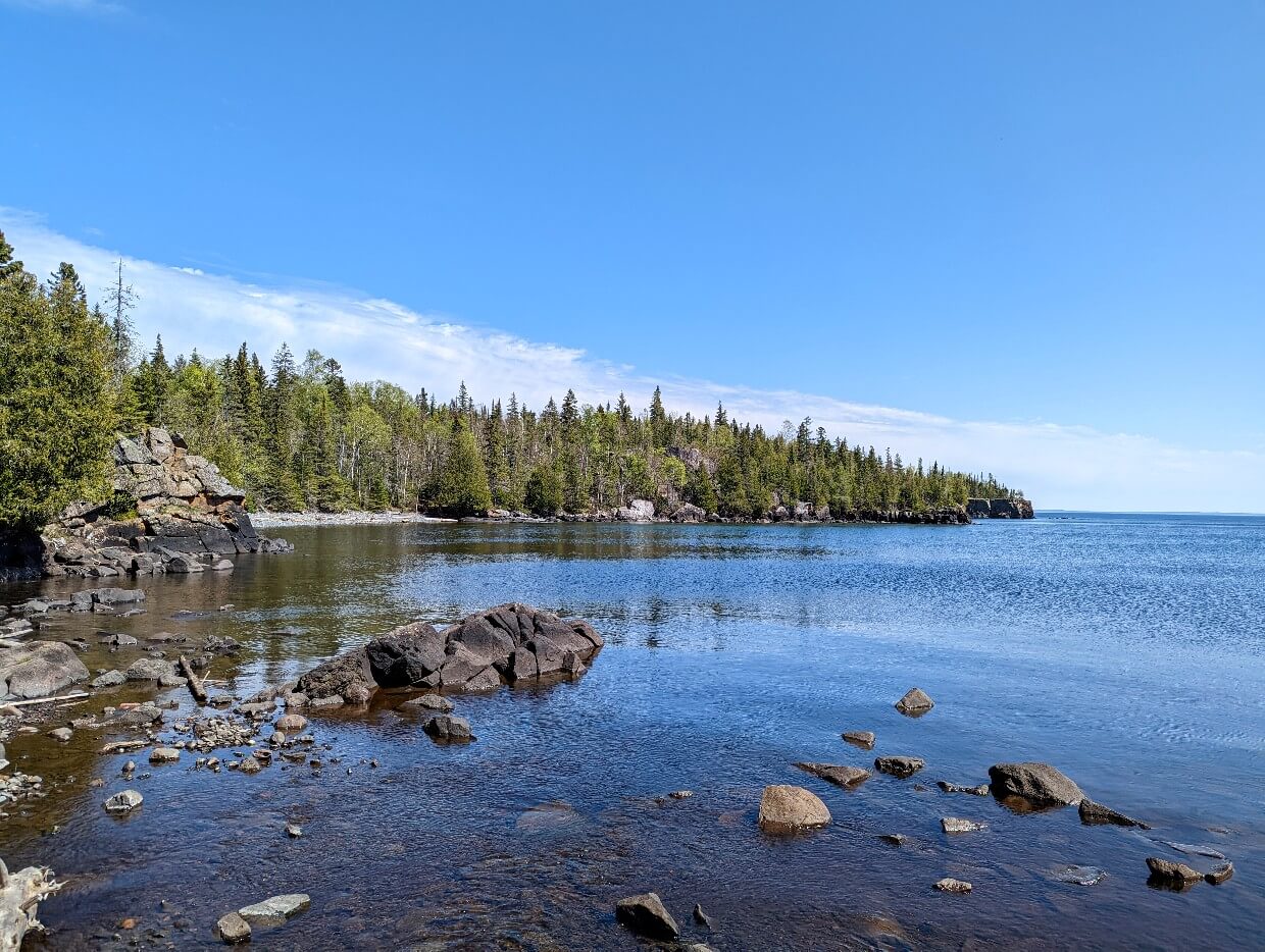
The first 6.8km of the hike takes place on the Kabeyun Trail, a wide and mostly flat rock and dirt path which roughly follows the shoreline of Lake Superior.
For the most part, the trail is surrounded by forest. This section is easy to hike but a little tedious at times (especially on the return journey). Some hikers choose to cycle it for that reason.

Tee Harbour to the South Talus Lake Trail Junction
At the 5.8km mark, you’ll reach Tee Harbour. There is a beach access here – this is a great place for a snack break or rest.

Back on the trail, it is only another 900m until the South Telus Lake Trail Junction. This is located on the right.
There is a bike rack here and prominent signage.

South Telus Lake Trail Junction to Top of the Giant Trail Junction
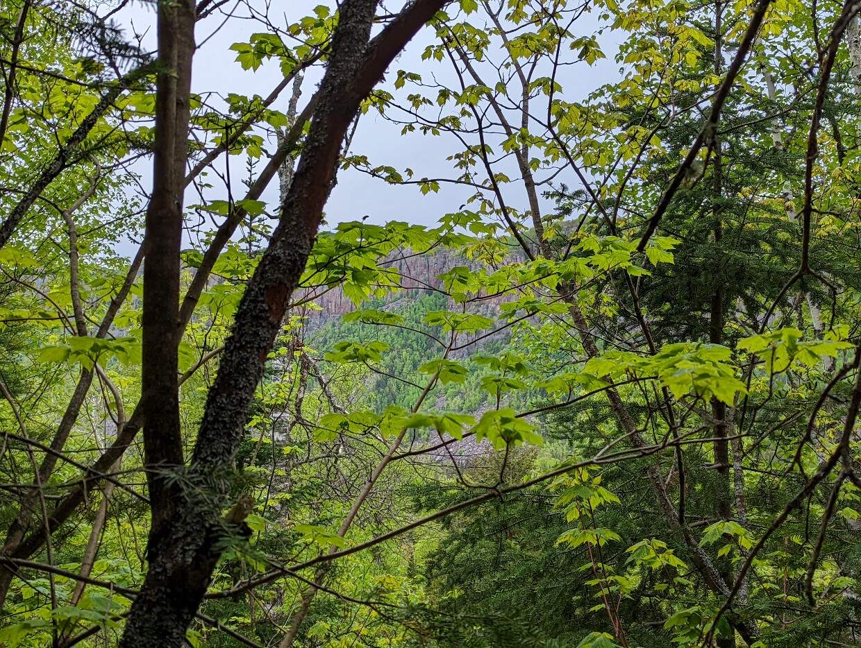
It’s now time to turn away from Lake Superior and head inland. The trail narrows and gets a little more difficult too, starting with a short uphill section. There are some wooden steps to climb.

Look through the trees to see a glimpse of the Sleeping Giant cliffs – yep, that’s the hill you need to climb!
The path then slopes down as it heads towards the Top of the Giant Trail Junction. Look out for the signed left turn.
Top of the Giant Trail Junction to the Top of the Stairs
The first part of this section is fairly flat as it winds through a wetland area.
There is a large pond with a healthy frog population – listen out for them in the early morning. Some surprisingly large trees sit close to the water.

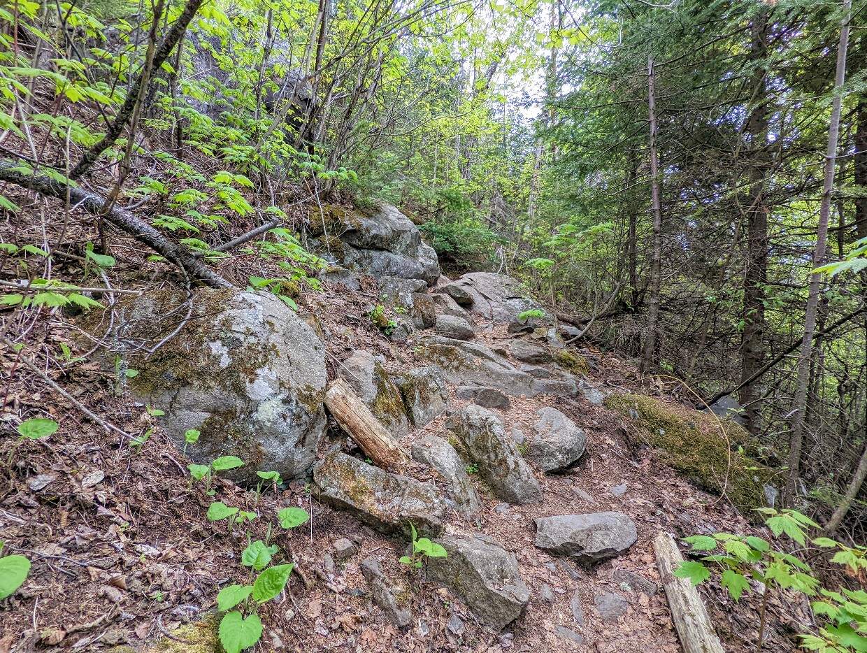
Moving away from the pond, it’s now time to start the big climb up ‘the Stairs.’
The trail ascends 211m over the next 1.2km, with the help of manmade wooden steps as well as some tree roots and rocks.

The climb is non-stop and steep at certain points; just take a break if you need to catch your breath. It’s better to take your time as the surface of the path is often uneven (example photos later in this guide).
The end of this uphill section is marked with a blue and white ‘Top of the Stairs’ marker. A wooden log over the creek acts as a good resting bench.

Top of the Stairs to the Tee Harbour Lookout
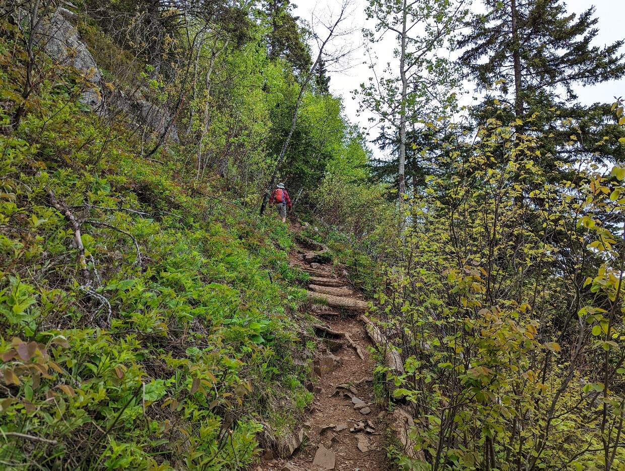
From the Top of the Stairs, the path winds its way along the edge of the cliffs. The views get better and better as the trees start to disperse. This section can be muddy, even in late spring.

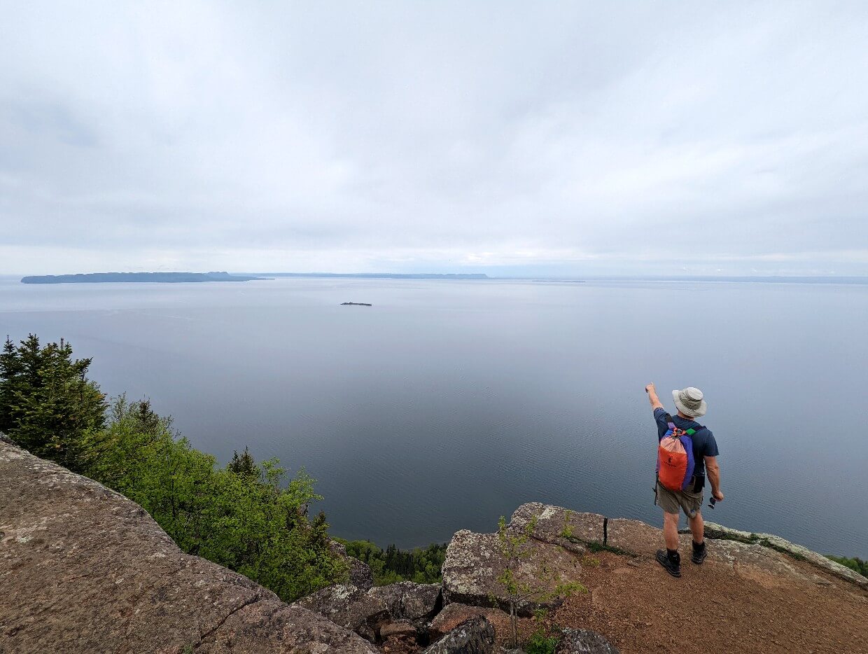
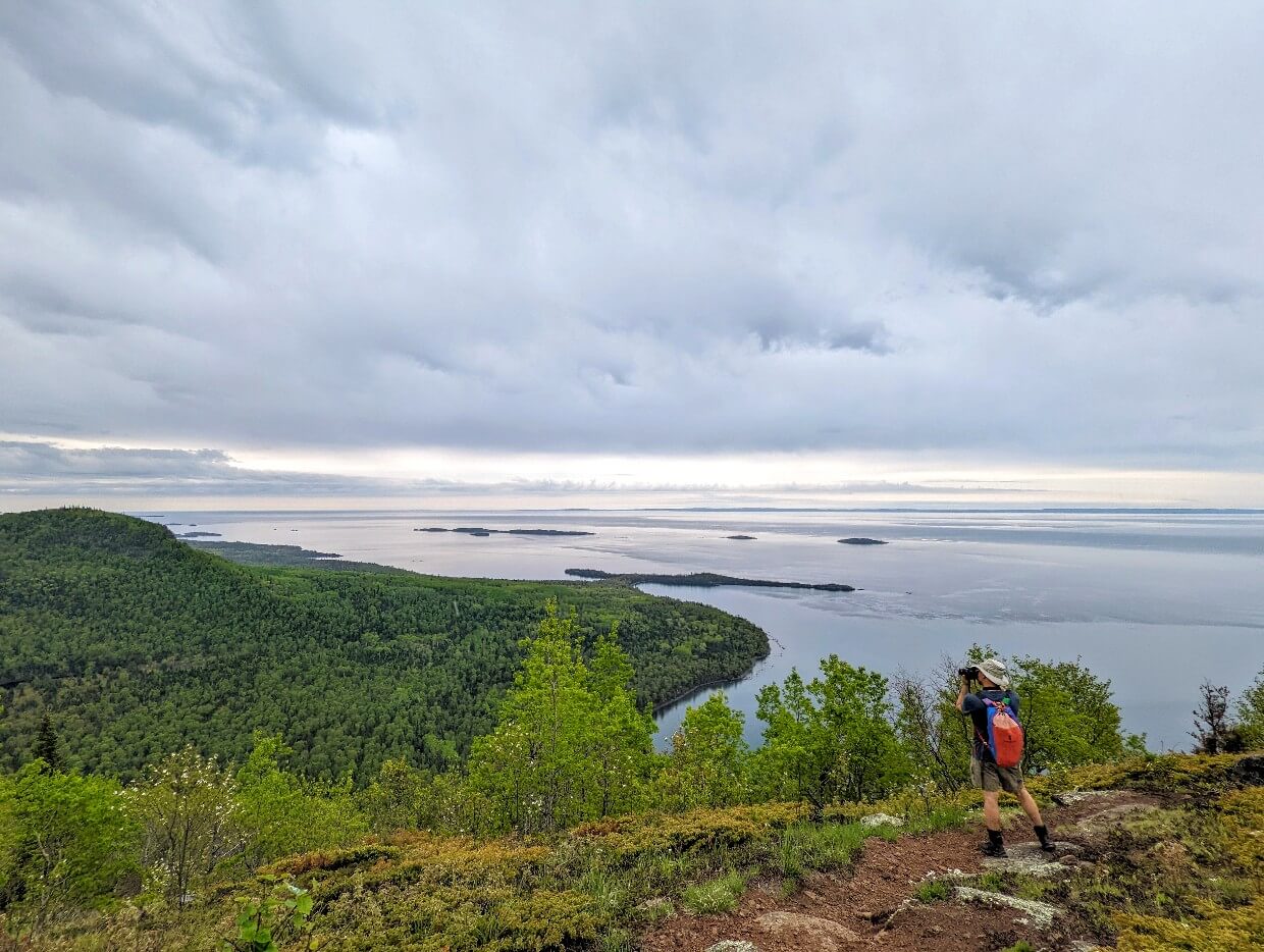
The Tee Harbour Lookout appears after 1.2km, offering stunning panoramas of Lake Superior and the forest below. It’s easy to see why Tee Harbour was named as such from up here (look at the shape)!

On a clear day, it’s also possible to see across to Isle Royale National Park in the USA. Be careful to keep back from the steep drop-off while admiring the views.
There is a Thunderbox (small open wooden outhouse) hidden in the forest behind the Tee Harbour Lookout.

Tee Harbour Lookout to the Gorge Lookout
From the Tee Harbour Lookout, it’s less than 1km to the final Gorge Lookout. The path travels back into the forest, with the views disappearing for 600m or so.
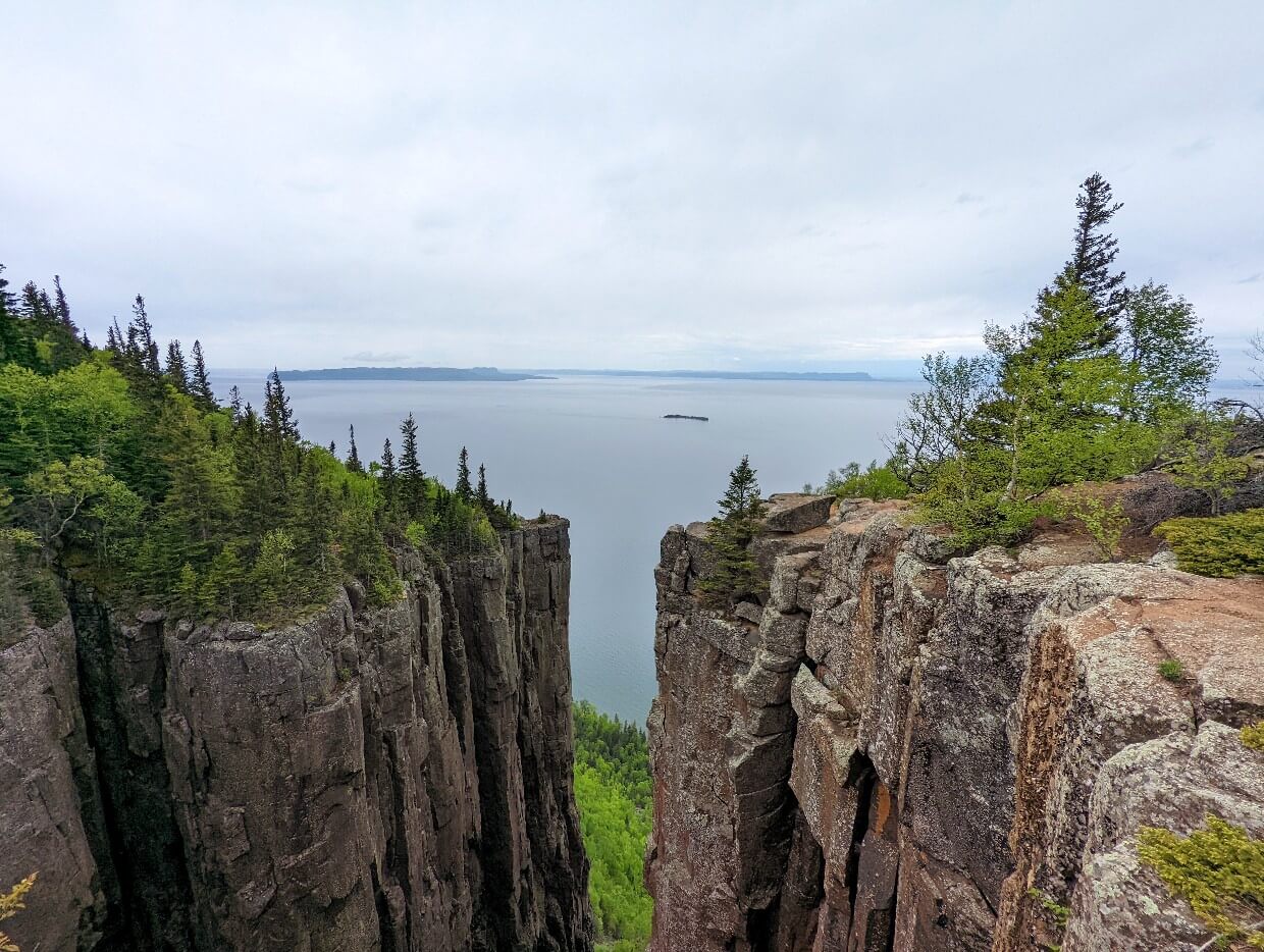
At this point, the vistas reappear quite spectacularly with a viewpoint showcasing the 300m high cliffs as well as Lake Superior. Again, keep well clear of the cliff edge here.

The Gorge Lookout is just around the corner. An open area appears, with huge rock steps and deep cracks.
Pick your way carefully towards the edge to view the cavernous gorge below. More fabulous views of Lake Superior form the backdrop. This is an ideal lunch spot.

Gorge Lookout to South Kabeyun Trailhead
The return journey is the same path you followed to get here. While the majority of the route is downhill, don’t underestimate it!

The last 6km or so are likely to be very tiring. Consider a snack stop at Tee Harbour to break up the journey and keep morale high.
If you still have some energy (and time), consider a side trip to the Sea Lion Rock Arch. It’s 400m one-way, with the trailhead located just 800m from the South Kabeyun Trailhead.
Most hikers will return to the parking lot around 7 to 9 hours after starting the hike. We spent just over 6 hours on the trail, with a 30-minute lunch break at the Gorge.

Top of the Giant Trail Hiking Guide
Inspired to hike to the Top of the Giant? In this section, you’ll discover everything you need to know to start planning a trip.
Directions
The Top of the Giant Trail is located in Sleeping Giant Provincial Park in northwestern Ontario. The park occupies most of the Sibley Peninsula which projects into Lake Superior.
The closest city is Thunder Bay, 66km to the east by road (measured from park boundary). Highway 17, the Trans Canada, passes just north of the Sibley Peninsula.
To access the park, turn onto Highway 587. The park’s boundary is crossed at the 42km mark, as noted by roadside signage.
The South Kabeyun Trailhead is situated 22.4km (20 minutes) further along Highway 587, on the right hand side of the road.

When to go
While Sleeping Giant Provincial Park is open all year round, the Top of the Giant Trail is best hiked from June to September.
The weather is warmest at this time and the trail is mostly dry. Note that July and August can be a little hot and occasionally humid.
Overnight temperatures can still be chilly at this time (sometimes single-digit figures) so keep this in mind if camping.
The park receives a lot of snowfall in winter. With the peninsula jutting into Lake Superior, it is also vulnerable to cold winds.
The Top of the Giant Trail is not recommended for hiking/snowshoeing in winter due to the short days and potentially treacherous conditions on the uphill section and clifftop viewpoints.
Depending on the year, snow lingers in the park until late April or early May. The trail is muddy for most of spring, which is why this is not the best time to visit.
Mosquitoes can also be an issue in spring, though the Lake Superior winds do help. We did not have any problems with flying insects on our mid-June visit.
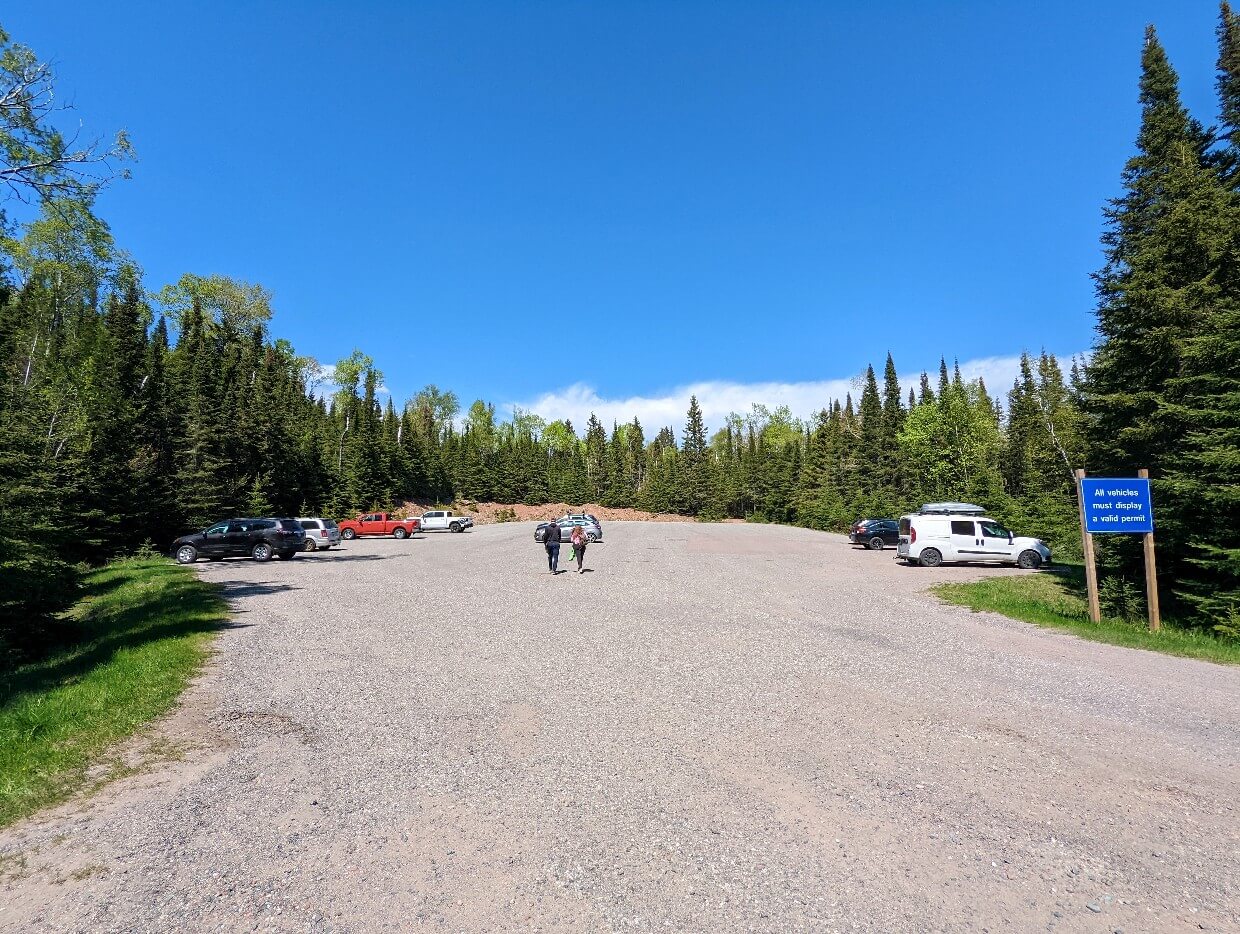
Parking
The main parking lot for the Top of the Giant hike is located at the South Kabeyun Trailhead. It is located 20 minutes drive from the entrance of Sleeping Giant Provincial Park, close to the end of Highway 587.
There is large, brown signage indicating the right-hand turn into the lot – look for ‘Kabeyun Trailhead.’
The paved parking lot is pretty large, though can get busy in the summer months. There is a large information board with a map as well as two outhouses.
Vehicles parked anywhere in Sleeping Giant Provincial Park need to display a valid day use permit. Self-serve permit machines are located at Joeboy Lake (north end of the park) and also in the Marie Louise Campground.
It is also possible to purchase a permit at the Marie Louise Campground gatehouse. Staying overnight? A permit is included with your camping fee.
Navigation
The Top of the Giant Trail is well signed, with bright distance markers at each junction and also in the main parking lot (South Kabeyun Trailhead).
The trail is well-used and maintained, with the path easy to follow for the majority of the route. This is especially true for the first part of the hike, which follows the wide Kabeyun Trail.
The trail is less defined between the Tee Harbour Lookout and the Gorge Lookout, due to the narrower width and surrounding heavy brush.
Just before reaching the Gorge Lookout, multiple small trails branch off the main one and lead to different viewpoints.
Click to view the Ontario Parks’ Sleeping Giant Provincial Park trail map.
The Top of the Giant Trail is accurately marked on the Maps.me app, which we used to check distance and positioning. Maps.me works offline, but only if you download the relevant map sections before heading to the park.

Trail difficulty
In my opinion, the Top of the Giant Trail is a moderately difficult trail, mainly due to its length (22km return from the South Kabeyun Trailhead) and relatively steep elevation gain during the ‘Stairs’ section.
Depending on your own fitness and experience, you may find this trail to be more challenging than my grading. Notably, Ontario Parks rates the trail as difficult (black diamond, the hardest ranking).
Be sure not to underestimate how fatiguing it can be to walk 22km in one go.
If you don’t hike often (or hike mostly flat or short trails only), you may find the overall physical exertion of hiking this trail to be very tiring.
Some preconditioning (training) is a good idea if you’re not an experienced hiker.

Try to go hiking more often and purposely choose longer trails, some with elevation gain (hills). The fitter you are, the easier this hike will be. And you’ll probably enjoy it more too!
When hiking the actual Top of the Giant Trail, be sure to start early (9am or earlier) and take your time. Bring lunch and plenty of snacks and water.
I’d suggest breaking up the hike into small sections with an extended rest after each one e.g. trailhead to Tee Harbour Junction (5.8km), Tee Harbour to Top of the Stairs (3km), Top of the Stairs to the Gorge Lookout (2.1km). Stop when you need to when going uphill.
Safety
Keep the following safety considerations in mind when planning to hike the Top of the Giant Trail:
- There is no phone signal in Sleeping Giant Provincial Park. Tell someone where you are going and when you plan to be back. We carry a satellite inReach device for emergencies
- Steep drop-offs. This trail features quite a few areas with sheer vertical cliffs. While it is not required to hike directly alongside any steep drop-offs, the best viewpoints are surrounded by them. Stay clear of the edge and keep children and dogs under close control
- Black bears roam this area. While they are not commonly seen on this trail (and don’t like to be around humans in general), hikers should always make noise to make their presence known. Travelling is groups is preferable. Dogs should be on a leash. Bear spray is optional but helpful in the very rare event of a negative encounter. More bear safety tips
- At 22km return, this is a long day hike. If you are not used to hiking distances like this, be sure to pace yourself. Don’t get summit fever – if you can’t make it to the end, the views will still be there next time. Getting home safe (and uninjured!) is more important. More outdoor safety tips
- Start your hike early. Depending on your fitness (and preference for snack/photo stops), hiking this trail will take 6 to 10 hours. Plan to start and finish in the daylight. Avoid the hottest part of the day during the summer months (see below)
- This trail can get hot. The average daytime temperature in this area in July is 24°C. While that may not sound scorching, hiking uphill at that temperature can be pretty uncomfortable. Bring plenty of water (2l+) and plan to start hiking early. The hottest time of day is around 3pm

Camping options
Consider staying overnight in Sleeping Giant Provincial Park, before or after your Top of the Giant hike. Reservations can be made online or by phone.
Frontcountry (vehicle accessible) camping
For frontcountry camping, check out Marie Louise Lake campground. There are 201 camp spots available, half with electrical service.
Some campsites are located right on the lakefront with views of the Sleeping Giant itself. The campground is 5 minutes drive from the South Kabeyun Trailhead.
Not a fan of tents and don’t have an RV? Marie Louise Lake campground also has 5 cabins for rent. These offer three bedrooms, kitchen facilities and a private washroom (with running water!) Bring your own linen.
Backcountry camping
Sleeping Giant Provincial Park has seven backcountry camping ‘zones.’
The Tee Harbour Zone features ten campsites and a gorgeous beach. It is located just off the Kabuyen Trail, 6km from the southern trailhead (12km return).
This is an ideal camping area for hikers wanting to break up the 22km hike with an overnight stop. I would suggest hiking to Tee Harbour, setting up camp and then continuing on to the Top of the Giant with a day backpack.
An alternative camping area would be the Lehtinen’s Bay Zone. This small camping area has only three campsites and is also situated on the Kabuyen Trail. It is located 700m past the South Talus Lake Trail Junction (7.4km from the South Kabuyen Trailhead).
A backcountry camping permit is required to stay at either of these two camping areas, with reservations recommended to secure your preferred date.
Individual campsite selection is available on a first-come, first-served basis. Each campsite has a designated firepit as well as outhouse access (or Thunderbox) and shared bear-proof stainless-steel lockers.
Nearby accommodation
If camping isn’t your style, staying in Thunder Bay is your best option. This city is just over an hour’s drive from the South Kabeyun Trailhead and has a good selection of hotels, motels, guesthouses and vacation rentals. There’s a highly rated hostel as well.
Our top picks are:
- The Courthouse Hotel – Enjoy modern amenities with historic ambience at this converted municipal building. This characterful hotel features spacious rooms, complimentary breakfast and a convenient downtown location
- Holiday Inn Express – The best rated two star chain hotel in the city, this Holiday Inn is situated in the commercial area of the city. The swimming pool area has a hot tub, perfect for relaxing post-hike! Complimentary hot breakfast is included
- Delta Hotels Thunder Bay – This upscale hotel is perched on Thunder Bay’s waterfront, with some rooms offering lake views. The boardwalk is just a few steps from the front door, providing easy access to restaurants and entertainment
If you have more time in the Thunder Bay area, we have plenty of other ideas for ways to spend your time! I’d highly recommend checking out some of the many local waterfalls.
What to bring
With the Top of the Giant hike being so long (22km), it is a good idea to bring the 10 Essentials. Not familiar with the concept?
The 10 Essentials are:
- Food – Carrying extra food is important in case of unexpected delay
- Water – Dehydration is dangerous – water is essential for the body to perform well. If you don’t like carrying much water, bring equipment to purify or filter water
- Extra insulation – Bring additional clothes and accessories for the coldest possible conditions during the season you are travelling in
- Sun protection – Prevent sunburn and sunstroke with a sun hat, sunscreen and sunglasses. SPF rating clothing is recommended
- Shelter – An emergency blanket is a lightweight option for hiking the Top of the Giant Trail in summer
- Navigation – Always carry a detailed map to identify your location
- First Aid supplies – At the very least, bring some antiseptic wipes, band aids, blister plasters, pain killers and antihistamines for allergic reactions
- Fire starters – Waterproof matches are a lightweight option
- Light source – According to some search and rescue agencies, 90% of call outs for overdue hikers involve people who don’t have a headlamp
- Repair kit – Duct tape or Tenacious Tape are all-purpose, fix everything lightweight saviours
These items can help prevent small inconveniences in the backcountry (changes in weather, injuries, other unexpected events) becoming life threatening emergency situations.
If this list sounds intimidating, keep in mind that most of these items are probably in your vehicle anyway (First Aid kit, sun protection, extra clothing, emergency blanket etc.)
Other items I’d recommend for this hike are:
- Hiking poles. If you have knee issues, you may find it helpful to have a pole or two to ease the pressure on your knees during the descent. We love Black Diamond’s incredibly lightweight Carbon Z series
- Insect repellent. We didn’t have any issues with blackflies or mosquitoes in mid June (usually the worst time for them!) but it’s always a good thing to have
- Trash bag. Pack out everything you bring in with you, including trash and biodegradable items like apple cores and orange peels
- Toilet paper. I never rely on backcountry outhouses to have toilet paper. Stash some toilet paper in a Ziploc bag to keep it dry.
Frequently Asked Questions about the Top of the Giant hike
If you still have questions about the Top of the Giant Trail, you may find the answer here!
No. The nearest parking lot is located at the South Kabeyun Trailhead, 11km from the end of the Top of the Giant Trail (Gorge Lookout).
The return distance for the Top of the Giant Trail itself is 6.6km. But since there is no parking lot here, it is necessary to hike additional trails to reach the trailhead.
The most popular route to the Top of the Giant is a 22km long day hike from South Kabeyun Trailhead.
Not directly, no. The nearest backcountry campground is at Lehtinen’s Bay Zone and then Tee Harbour. The nearest frontcountry (vehicle accessible) campground is Marie Louise Lake Campground.
If you are in good fitness and regularly hike long distances/up hills, allow 6 to 8 hours.
If you don’t hike often or usually hike short, mostly flat trails, allow 8 to 10 hours.
Hikers who use a bike to cycle the Kabeyun Trail from the parking lot to the South Talus Lake Trail Junction can save about an hour in each direction (two hours total).
Yes, black bears live in and roam Sleeping Giant Provincial Park. Keep in mind, though, that bears are smart and don’t like to be around humans.
If a bear hears you, they will usually get out of the way. So make noise as you hike. Other tips – travel in groups, keep dogs on a leash and watch for signs of bears.
Carrying bear spray is a good ‘just in case’ measure (it makes me feel much more confident too!), especially if you’re hiking during a less busy time of the year.
Yes, but all dogs must be kept on a leash. Not only does this help avoid negative wildlife encounters, it shows respect to other hikers as well. It’s also important for safety – this trail features some super steep drop-offs.
There is a ‘Thunderbox’ (a wooden box with a toilet seat on it) in the forest close to the Tee Harbour Lookout. There’s two outhouses in the parking lot as well.

Read these Ontario articles next:
Highway 17 Road Trip: 10 of the Best Ontario Parks
Quetico Provincial Park, Ontario: Complete Canoe Paddling Guide
Lake Huron Fishing with Angling Algoma, Northern Ontario
Finding Adventure in Toronto: Best Places to Go, Things to Do & More
Paddling the Trent Severn Waterway near Campbellford, Ontario

One half of the Canadian/British couple behind Off Track Travel, Gemma is happiest when hiking on the trail or planning the next big travel adventure. JR and Gemma are currently based in the beautiful Okanagan Valley, British Columbia, Canada. Consider buying us a coffee if you have find any of our guides helpful!
Excellent, well-detailed post. Really enjoyed reading about your experiences. Thanks for sharing.
So glad you found the post helpful Antony! Thanks for letting me know, I appreciate it. Have a great hike