Featuring dramatic looking granite spires, Bugaboo Provincial Park is legendary for climbers. But it has a lot to offer hikers too.
The most popular route into the core of the park is the Conrad Kain Hut Trail. In this case, the journey is as exciting as the destination.
The steep climb feels more like a staircase in places and also includes two chain-assisted sections and a ladder.

Such a fast ascent reveals sweeping views of glaciers, waterfalls and the iconic mountain peaks quickly. In late September, the alpine larch trees turn golden and light up the scene (that’s when we hiked this trail!)
Bugaboo Provincial Park had been on my list for a long time before we finally managed to visit as part of a fall trip to the Columbia Valley.

It was well worth the wait – I now rate this trail as one of my favourite day hikes in all of BC. And I’ve hiked a lot of trails across the province, from Vancouver Island to the Okanagan and also in the Rockies.
In this post, I’ll share what you need to know about hiking the Conrad Kain Hut Trail in Bugaboo Provincial Park, including a trail overview, safety tips and campground info.
17th August update – please note that this trail is currently closed due to flood damage. Check the BC Parks’ website for updates.
Conrad Kain Hut Trail
Location: Purcell Mountains, between Golden and Radium
Distance: 10km return (+2km to Applebee Dome)
Elevation gain: 700m (+255m to Applebee Dome)
Hike type: Out and back
Time: 4 to 6 hours, 6 to 8 hours with Appledome Dome
Difficulty: Challenging
Camping: Yes, two campgrounds and cabin
Fees: $10/per person/per night for camping, $25/pp/pn for cabin
When to go: Mid July to late September
Dogs: Not permitted
Backcountry necessities
- Always bring the 10 Essentials
- Know how to stay safe in the backcountry
- Remember to Leave No Trace to help keep the wilderness wild
- Understand how to avoid negative bear encounters
- Trying out backpacking for the first time? Read Backpacking 101
- Check out our packing guide with gear recommendations
- Sign up to our newsletter for a free backpacking checklist
The Conrad Kain Hut Trail, Bugaboo Provincial Park
Bugaboo Provincial Park is a remote, high alpine destination situated in the Purcell Mountains of British Columbia. The park protects many 3000m high peaks with granite spires, shaped by glaciers and weather.
The Bugaboos are a major draw for local and international rock climbers and mountaineers during the summer months. There are some hiking opportunities in the park too.

The most accessible route into the park is the Conrad Kain Hut Trail, which starts at the bottom of a steep V shaped valley and ascends the lateral moraine of Bugaboo Glacier. It’s completely free to hike – fees only apply for overnight stays.
While a relatively short trail (10km return), the hike up to the Conrad Kain Hut is not for the faint of heart.
Most of the total elevation gain (700m) is achieved in less than 3km, which makes the trail very steep. It often feels more like climbing stairs than hiking. There are quite a few switchbacks as well as a couple of interesting features (ladder, chains).
The trail ends at the spacious Conrad Kain Hut, which was primarily built for climbers in the 1970s. There are two backcountry campgrounds nearby, with the Applebee Dome being the most popular.

I enjoyed the hike up to the hut (and Applebee Dome) a lot more than I expected. I found the climb up the natural rock ‘steps’ a lot easier than a long slog up a slightly elevated path. The views of the surrounding valley and mountains appear quickly, something that always helps to motivate me!
The meadows section, near the hut, is absolutely gorgeous, with a stream running through the rocks and a backdrop of the granite peaks. In late fall, the scattered larch trees turn golden and make this scene even more beautiful.
It is important to note that this trail is very exposed for most of the route. We were snowed on in late September and there was nowhere to hide. During the summer months, it would get hot on sunny days. With a loaded overnight backpack, it would be significantly more difficult.

Who was Conrad Kain?
Curious who this high alpine hut and trail was named after? I was too!
Born in Austria in 1883, Conrad Kain came to Canada at 25 years old, primarily to work as the Alpine Club of Canada’s first professional mountain guide.
He is credited as part of the first group to survey the Bugaboos in 1910, alongside A.O. Wheeler, T.G. Longstaff and Byron Harmon.
Kain made many first ascents in the Rockies (such as Mt Robson) as well as in the Bugaboos. He is most closely associated with the Bugaboos after being the first to summit many of the highest and most technical peaks. He died in 1934.

Trail map
Below is BC Parks’ Bugaboo Provincial Park map, with a focus on the Conrad Kain Hut Trail. A larger version is available on the BC Parks website.
For on-trail navigation, check out the Organic Maps app. The access roads and trail were accurate when we used it in 2024. Be sure to download the appropriate maps for offline use.

Conrad Kain hike overview
The first part of the Conrad Kain Hut Trail is an easy, flat walk in the woods. There are a couple of stream crossings (with bridges) and a few potentially muddy spots.
At 1.3km, the first view through the trees appears. The Houndstooth is the most iconic granite spire in the Bugaboos and looks exactly as the name implies!

Not long after, the real trail begins. A few rocky switchbacks lead above the treeline and onto the side of the moraine.
And it’s all up from here! A blend of short and long switchbacks follow, some surrounded by hip height foliage. In summer, expect to see wildflowers, especially vibrant pink fireweed.

Around 2.3km, the switchbacks become steep and feature large rock steps.
The first chain section is at 3km, providing assistance to walk around a narrow rock band with a drop-off. It’s quite short and in dry weather, I imagine some people wouldn’t even hold the chain.

There is a metal ladder soon afterwards, helping to ascent a large rock slab. It’s about 15 rungs. I wish I’d worn gloves since it was a cold day.
A little further on, there are some more narrow sections around rock bands and then the second chain. This one is longer and more difficult, with the trail ascending a rock slab switchback (photo in difficulty section of this guide).

There are some small steps but it is also necessary to step right on the rock. It is a bit slippery when wet. More rock steps switchbacks follow.
Finally, at the 3.4km mark, the trail enters a beautiful meadow area with scattered larch trees and a meandering creek.

This is one of my favourite places on the trail. A couple more uphill sections and the hut is visible above.
Two short paths branch out from the hut – one heads uphill to the Applebee Dome, an exposed rock slab campground (extra 1km one way with 255m elevation gain).
The other descends slightly to the forested Boulder Campground (extra 300m one way with 80m loss).

Applebee Dome extension
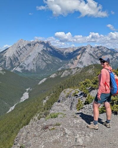
The views of the surrounding mountains and glaciers are impressive enough from the Conrad Kain Hut area but are even better from the Applebee Dome and the nearby alpine lake.
If you have the energy to continue after reaching the hut, I’d recommend spending the extra time to visit.

The route to Applebee Dome starts with some short but steep switchbacks through a rocky area. The dirt trail is fairly easy to follow for the first 600-700m.
After that, it becomes more rocky and the path less obvious. There are some cairns and a couple of signs for guidance but we definitely lost the main route a few times.
The good news is that the campground outhouses are visible for quite a while before you reach them – an ideal reference point!

The campground resembles a tent city throughout most of the climbing season, with colourful tents set up everywhere on the flat rock slab surface.
The views are extraordinary from here, with mountains in every direction.

Head northwest from the campground over more rock slabs to check out a pretty alpine lake (also the campground’s water source). It sits below some granite peaks – try to spot climbers if you can!
Looking to explore more in this area? The Eastpost Spire is one of the few non-technical spires that can be scrambled. It’s just above Applebee Dome campground.

How difficult is the Conrad Kain Hut Trail?
I would rate this hiking trail as challenging. While fairly short, the majority of the route is uphill, with some very steep sections.
The terrain is uneven in places, with large rock steps to ascend and rock slabs to cross. To put it in context, the most intense part is a bit like climbing stairs for a straight hour or so.
As mentioned, there are two chain sections, one of which requires more attention (I used my hands for balance in a couple of spots).
The ladder is short but is a trail feature that you don’t often see. It may feel more intimidating with a large and heavy backpack.

Some of the switchbacks have drop-offs on one side of the trail (not both). The path is not extremely wide but super narrow either.
Weather conditions can really impact this trail as most of it is exposed to the elements (no tree cover). Wet or snowy weather create slippery conditions, hot temperatures would make the climb feel feel relentless!
Allow 4 to 6 hours for the return trip to the hut, 6 to 8 hours to also visit Applebee Dome and the alpine lake. With the driving time in mind, it is a full day of adventure (if not staying overnight).

Camping options
There are two campgrounds in this area of Bugaboo Provincial Park plus the Conrad Kain Hut itself.
Conrad Kain Hut
Built in 1972, the Conrad Kain Hut is the most comfortable place to stay in Bugaboo Provincial Park. This well equipped hut is fully operational from the end of June to the end of September.
It has a spacious dining/kitchen area with propane stoves, a second floor sleeping area and additional loft space. Basic foam mattresses are provided. There is electricity and outhouses as well as hot and cold running water (boil first). Up to 30 people can stay here overnight.

Since you only need to bring food, a sleeping bag, clothes and personal items, staying at the hut reduces pack weight significantly. This is especially helpful for climbers, who are carrying a lot of additional gear.
Understandably, the Conrad Kain Hut is very popular. The downside? If you struggle with communal sleeping (and snorers), it’s probably not for you.
- Hut reservations can be made via the Alpine Club of Canada website. The cabin fee is $25/per person/per night (or $50/family)
- Remaining spots are available on a first come, first serve basis. There is an on-site hut caretaker
- Reservations are highly recommended during July, August and early September as it is usually full every night

Applebee Dome Campground
This exposed rock slab campground is 1km uphill from the hut, along a rocky and sometimes steep route (255m extra elevation gain). It is a tent city during the summer months, also the main climbing season.
The unobstructed views of the surrounding mountains are incredible (seriously, it’s one of the most impressive backcountry campgrounds in all of BC). Keep in mind that there is no protection from the weather and it is located at 2475m (anticipate wind, cold temps and even snow in summer).
There are several outhouses, food caches, metal racks for additional food storage. Campers filter water from the small alpine lake nearby. I’d recommend bringing a free standing tent as surface of the campground is just bare rock.

Boulder Campground
Situated downhill, on the ‘other’ side of the hut (250m and 80m elevation loss), this campground is less popular than Applebee as it is further from the main climbing area.
Mostly forested, Boulder Camp has better wind and weather protection than Applebee. There are some great mountain views through the trees. For facilities, there are some tent pads (and some extra flat spots), an outhouse and creek water source.
- Both campgrounds operate with a first come, first serve system (no reservations available)
- A backcountry permit is required to stay in either of the campgrounds from 1st July to 2nd October
- Buy the permit online to two weeks before your trip on the BC Parks website or from the park operator at the hut. The permit fee is $10/per person/per night
- From 2026, non-BC residents will be charged an additional $20 per stay, per camping group, at provincial campgrounds.
- Applebee Dome Campground is better for climbing and stargazing, while Boulder is more popular with hikers. Boulder is easier to reach (there is an extra climb up to Appledome!)
- Campfires are not allowed

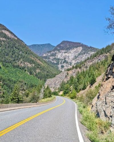
Bugaboo Provincial Park driving directions
Bugaboo Provincial Park is located between Golden and Radium Hot Springs, about 50km from Highway 95. Access is via unpaved Forest Service Roads only, the condition of which can vary.
There are blue provincial park signs leading most of the way from the highway to the Conrad Kain Hut Trail parking area.
First head to Brisco, a small Highway 95 community with a gas station. Brisco is about 20 minutes drive from Radium Hot Springs and 45 minutes from Golden.
- Turn off Highway 95 on Brisco Road (km 0). It crosses the railway and then the Columbia River.
- At kilometre 3.4km, stay right to continue on Brisco Road
- At kilometre 4.8km, there is a junction with Bugaboo Creek Forest Service Road. The easiest route is to stay right to continue on Brisco Road, as per the blue provincial park signs. The first part of Bugaboo Creek FSR is very rough (more info below)
- At kilometre 8.3km, turn left onto Westside Road
- Follow Westside Road for 2.6km
- At the junction (kilometre 10.9km), turn right onto Bugaboo Creek FSR
- Follow Bugaboo Creek FSR for 38km (48.9km total) – the trailhead is located at the end
- Be sure to turn right at kilometre 46.3km, where there is a large Bugaboo Provincial Park sign. If you turn left, you’ll end up at the CMH Bugaboos Lodge
It took us around 90 minutes to drive from Radium Hot Springs to the Conrad Kain Hut trailhead.
Brisco Road and Westside Road are pretty wide and well maintained unpaved roads. They receive some local traffic.

Bugaboo Creek FSR is narrower and maintained less often. It is pretty well used by hikers and climbers, however.
As noted above, the very first part of this FSR is very rough and also uphill, so it is well worth making the extra detour around it as described. It only adds 4km and is a much easier drive. If you have a 4X4 truck, you may not care.
I always recommend a high clearance vehicle for driving unpaved backroads in BC. As long as you take the detour around the roughest section of the Bugaboo Creek FSR, I don’t think a 4X4 vehicle is needed for summer visits (except during extreme weather!)
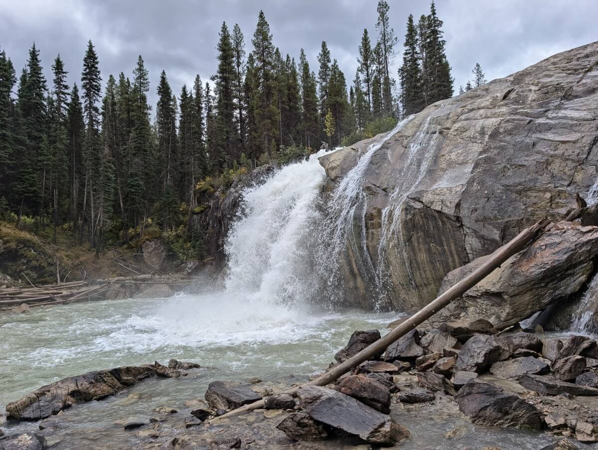
On the way back/to the trailhead, be sure to stop at Bugaboo Falls Recreation Site (kilometre 39.3). This roadside waterfall is really pretty!
Conrad Kain Hut parking area
There is space for around 35-40 vehicles at the trailhead, which also features an outhouse and signage.
In this area of BC, it is pretty common for overnight hikers/climbers in remote areas to protect their vehicles with chicken wire to deter porcupines from chewing on rubber hoses and tires.
For this reason, there is usually chicken wire piled up on parking lots, along with an assortment of rocks and wooden stakes to help prop it up.
I’m not sure if it’s an urban myth but I don’t have proof otherwise (and we’ve always protected our vehicle too!)
In the summer of 2024, there was communciation that BC Parks would remove any chicken wire left in Bugaboo parking lots. There was still plenty during our September visit, however. If in doubt, bring your own.

General safety tips
- Bring the 10 Essentials, even when day hiking this trail – these items will help prevent small inconveniences from becoming emergencies
- There is very little shade for most of the hike. Start early on hot summer days. Wear a hat and sunscreen. Stop often and drink plenty of water
- Weather conditions can fluctuate wildly in the alpine, even in the height of summer. Bring a waterproof jacket and warm layers
- There is a ladder and a couple of chain sections – watch your footing and don’t rush
- This is a particularly tough hike when carrying a heavy backpack. Lighten your load as much as possible while still bringing everything you need to be self sufficient
- Bears and other large predators do live in this area. Carry bear spray in an accessible place (like a belt holster) and know how to use it
- There is zero phone signal in Bugaboo Provincial Park and along most of the access road. Tell someone where you are going and when you plan to be back
- A satellite communicator is very helpful to have in case of an emergency. We carry an InReach device. The Conrad Kain hut has an on-site caretaker, who may be able to help in some situations
- Before leaving the highway, check that your spare tire is inflated and you know how to change it

You may find these other hiking posts helpful:
Mount Assiniboine Provincial Park: Complete Hiking Guide
Where to Find Golden Larches in British Columbia
Backpacking Gear List: Packing Guide for Multi-Day Hikes
Cape Scott Trail, Vancouver Island: Complete Hiking Guide
West Coast Trail Alternatives: Best Coastal BC Backpacking Trips
The HBC Heritage Trail (1849): Complete Hiking Guide
Check out these recently published posts:


One half of the Canadian/British couple behind Off Track Travel, Gemma is happiest when hiking on the trail or planning the next big travel adventure. JR and Gemma are currently based in the beautiful Okanagan Valley, British Columbia, Canada. Consider buying us a coffee if you have find any of our guides helpful!