There’s nothing quite like walking through a rainbow-coloured field of alpine wildflowers in midsummer.
Experience this yourself on the approachable Trophy Meadows Trail in Wells Gray Provincial Park.
With the parking lot being situated at 1700m, most of the elevation is gained before even stepping onto the trail.
A short but steady ascent through mixed spruce/fir forest transports hikers to sprawling meadows of alpine wildflowers.

More than 20 species of delicate wildflowers reach peak bloom here at the start of August.
But the wildflowers aren’t the only appeal of this trail. There are far-reaching views of surrounding and distant mountain peaks. Many small alpine lakes are scattered across the sub-alpine landscape as well.
The Trophy Meadows Trail can be hiked as a day hike but also as part of an overnight or multi-day adventure. The beautiful backcountry campground at Sheila Lake is an ideal destination for a first-time backpacking trip.


Read on to discover everything you need to know about the hike to Trophy Meadows and Sheila Lake, including an overview of the hiking experience, parking details, camping information and more.
Here’s what to expect in this post:
Wells Gray Provincial Park is located on the traditional territory of First Nations including Ktunaxa, Lheidli T’enneh and Secwepemc Nation.

Trophy Mountain Meadows / Sheila Lake
Location: Wells Gray Provincial Park
Distance: 10km return to Sheila Lake
Elevation gain: 400m
Hike type: Out and back
Time: Allow 3.5 to 4 hours to Sheila Lake and back
Difficulty: Low to moderate
Camping: Yes
Fees: None
Dogs: Not recommended

Backcountry necessities
- Always bring the 10 Essentials
- Know how to stay safe in the backcountry
- Remember to Leave No Trace to help keep the wilderness wild
- Understand how to avoid negative bear encounters
- Trying out backpacking for the first time? Read Backpacking 101
- Check out our packing guide with gear recommendations
- Sign up to our newsletter for a free backpacking checklist

An introduction to the Trophy Meadows Trail and Sheila Lake
The Trophy Mountains are located in Wells Gray Provincial Park, a large wilderness area in east central British Columbia, Canada. The chain features nine summits, with the highest topping out at 2,577m.
Carved by thousands of years of glacial and volcano activity, the southern slopes of this mountain chain are covered in gently rolling sub-alpine terrain featuring many small lakes and extensive wildflower meadows.

Thanks to the Trophy Meadows Trail, these beautiful meadows are some of the most easily accessible in British Columbia.
This post primarily concentrates on the Trophy Meadows Trail from the parking lot to Sheila Lake, with an optional loop route through the Plateau of Lakes. This trail is also known as the Sheila Lake Trail or Trophy Mountain Trail.
Sheila Lake, the largest waterbody in this area, makes for an excellent lunch stop or overnight hike destination. Further hiking opportunities lie just beyond the lake.

Trophy Meadows Trail: Hike Experience
Here’s a brief overview of what to expect while hiking the Trophy Meadows Trail to Sheila Lake and the Plateau of Lakes.
- The return distance to Sheila Lake is 10km. Allow 3 to 3.5 hours.
- The total distance for the Viewpoint/Little Hut/Sheila Lake loop is 11.6km. Allow 4 to 4.5 hours
I would rate the Trophy Meadows Trail to be low to moderate difficulty, depending on your own fitness and experience. If you’re a regular hiker, you’ll likely find it to be low difficulty.

The elevation gain is relatively gentle overall. The reward to effort ratio is high, with most hikers reaching views and wildflowers within one hour of leaving the parking lot.
If you don’t have the time and/or hiking ability, consider turning around the 3km point (6km return). Allow two hours for this shortened hike.

Parking lot to the meadows
The Trophy Meadows Trail starts at the end of the parking lot. If you’re lucky, you’ll see some wildflowers before even stepping onto the trail!
The first section of the hike features a number of wide switchbacks as the trail steadily climbs through the Engelmann spruce and sub-alpine fir forest. The path is mostly dirt with scattered rocks and roots.
BC Parks claims that it is only about 1km (and 45 minutes) to the first meadows but I would say that it is a little beyond that in terms of distance.

The path continues to ascend after reaching the first meadow, finally leveling out some at the 2.5m mark after 250m elevation has been gained.
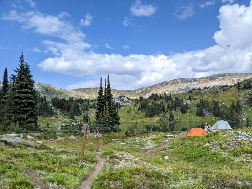
At this point, the views really start opening up. Mountain peaks start to rise in the distance and the trail is surrounded by vast wildflower meadows.
The path is sloped uphill here, but you’re unlikely to notice much since there’s so much to look at! Some sections of the trail can be muddy, especially after recent rain.

Old Ronacher hut to Sheila Lake junction
The ruins of an old cabin appear on the left at the 3.3km mark. This hut was built by John Ronacher in the 1940s, using only an axe. He herded sheep in these lush meadows until the early 1960s. An outhouse is now situated behind the cabin.

Past the hut, the views just get better and better as the trail starts to gently ascend again. This is where we saw the best wildflowers on our mid-August hike (after the main bloom).
Up over a hill and a couple of very large rocks appear ahead. Turn left at the junction for Sheila Lake (5km) or turn right to head towards the rocks.

Extending the Trophy Meadows hike
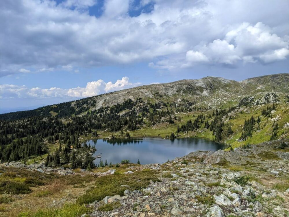
The Sheila Lake Viewpoint (4.6km from the parking lot) is found atop the largest rock, offering excellent panoramas of Long Hill rising above Sheila Lake as well as the trail below and distant mountain peaks across the valley.

If you’re feeling tired at this point, consider heading back down to Sheila Lake. The Sheila Lake detour is 900m return from the junction.
Alternatively, you can continue on the right-hand uphill trail from the Viewpoint to the top of Little Hill (2126m). This vantage point offers views towards the Trophy Mountains.

Plateau of Lakes loop
To complete a loop, backtrack down to the Viewpoint and follow the parallel path along the ridge above Sheila Lake to the ‘Plateau of Lakes.’
The narrow dirt trail (easy to lose at times) passes several pretty tarns before reaching a junction. A sharp left turn heads down to Sheila Lake (6.7km). The right-hand turn leads to the Long Hill summit (3km return, 200m elevation gain).

Approaching Sheila Lake, the path follows the western shore and passes through the backcountry campground.
The route back to the main junction (near the Viewpoint) from Sheila Lake is uphill. From here, the return route to the parking lot is the same – down the hill, past the hut, through the meadows and back into the forest.

Trophy Meadows / Sheila Lake Hiking Guide
Inspired to check out the Trophy Meadows / Sheila Lake Trail? Read on to discover everything you need to know about this gorgeous hiking trail in Wells Gray Provincial Park.
This post includes some affiliate links. If you make a purchase via one of these links, we may receive a small percentage of the sale at no extra cost to you.

When to go
The Trophy Meadows trailhead is usually accessible from late May to early October.
The main hiking season, however, usually starts in early July, after most of the snow has melted. Delicate glacier lilies bloom in the meadows from late June to early July.
The best time to hike Trophy Meadows is late July to early August when the wildflowers are at their peak. This is also the most popular time to visit so it can be busy. The exact dates of the bloom vary from year to year, but early August is usually pretty reliable.
Some wildflowers were still around during our mid-August visit. We enjoyed the quieter trail and also the lack of flying insects, which could be a major issue earlier in the summer.

How to access the Trophy Meadows trailhead
The Trophy Meadows trailhead is located 13km from Clearwater Valley Road i.e. the Wells Gray Corridor. It is accessed via two unpaved dirt roads, which climb almost 1000m to the parking lot.
The turnoff for Spahats Creek Forest Service Road/Road 80 is 12km along the Clearwater Valley Road. It is situated on the right-hand side of the road, 1.1km after the signed Spahats Falls junction.

Drive 4.2km along the Spahats Creek FSR and then turn left at the signed Trophy Mountain junction (Road 10). Continue for 3.4km and then stay right at the split (Road 201).
Ignore small branch roads and continue for another 5.3km. This final section is steeper and features a couple of switchbacks. The road ends at the Trophy Meadows parking lot.
The condition of the route depends on recent maintenance. I would not take a very low clearance vehicle on this road as there can be loose rocks and washboard. Industrial traffic may be encountered so prepare to drive slowly and give way.

Trophy Meadows parking
The parking lot for the Trophy Meadows trailhead is pretty large, with space for around 25 vehicles. There is an outhouse and trail signage. The trailhead is located at the far end of the parking lot.
Technically, the parking lot is not located within Wells Gray Provincial Park. The park boundary is crossed about 500m up the trail.

Navigating the trail
The Trophy Meadows Trail is well travelled, with an established dirt path leading the way from the parking lot all the way to Sheila Lake (5km). BC Parks signage indicates the turnoff to the lake.
A secondary path branches away from this trail about 450m before the lake, towards the Sheila Lake Viewpoint and Little Hill summit (2126m).
From here, the trail turns and runs parallel to Sheila Lake, traversing the Plateau of Lakes. The path eventually turns again and returns to Sheila Lake.

There are many lesser used trails in the Plateau of Lakes area, which can prove confusing. If in any doubt, return the way you came.
Try to stay on the trail at all times as even one step can permanently damage the delicate landscape here. There are very few trees on this plateau which does make it easier to maintain orientation.
The Trophy Meadows Trail is featured on our favourite navigational app, Maps.me. Be sure to download the maps before leaving Clearwater so you can use them offline. The route is also displayed on AllTrails.

Fees
- Hiking the Trophy Meadows Trail is completely free!
- There are no day-use fees for visiting Wells Gray Provincial Park
- There are no camping fees for staying at the Sheila Lake backcountry campground either (more details below)

Safety considerations
Though the Trophy Meadows Trail is fairly well used in summer, it is still located in a remote backcountry area.
Here are some of the main hazards to be aware of:
- Weather. Conditions can change quickly in high-elevation areas such as this. Snow is possible even in the middle of summer. The weather in the meadows may be different than it is in the parking lot
- Elevation gain. The climb to the meadows is not steep but if you do not hike regularly, you may still find it tiring. Pace yourself
- Bears. Wells Gray is home to both grizzly and black bears. Though bears are not commonly seen, stay alert and be sure to make noise around any blind corners. If you do see a bear, give them plenty of space and an escape route. Read our bear safety guide
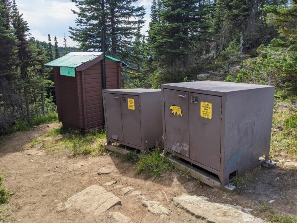
- Food storage. Staying overnight at Sheila Lake? Maintain a clean camp and keep all food and attractants in the bear caches when not in use
- Communication. There is very little phone signal in Wells Gray Provincial Park. Tell someone where you’re going and when you plan to be back. Bring a satellite communication devices (Inreach or Spot) for emergencies
BC Parks does not recommend bringing dogs into backcountry areas due to wildlife disturbance and the sensitive nature of the landscape.

Trophy Meadows / Sheila Lake camping
Sheila Lake features a wonderful backcountry campground with tent pads, bear caches and an outhouse close to the shore.
With the access route being relatively short and easy, it is an ideal destination for a first-time backpacking trip. Sheila Lake is even swimmable, though cold.

The surroundings are absolutely gorgeous and there are some great day hiking opportunities (Long Hill, West Summit, Trophy Skyline) for adventurous folks.
As of 2024, there are 20 wooden tent pads at the Sheila Lake campground. There are also new cooking shelters, food caches and outhouses.
We last visited in 2021 when there were 7 tent pads, which were all spaced quite well. Most offered lake views.
Using the provided tent pads reduces the risk of damage on the delicate sub-alpine landscape.

BC Parks warns that longer guy lines may be needed to use the tent pads and we found this to be true.
All of the tent pads we examined did not have any hooks or fixtures. Consider bringing an extra length of cord, especially if you do not have a self-standing tent.
Backcountry camping is completely free at Sheila Lake. Please note that campfires are not allowed.


Essential items to bring
As well as the 10 Essentials, I would recommend bringing the following items when hiking the Trophy Meadows:
- Hiking poles. If you have knee issues, you may find it helpful to have a pole or two to ease the pressure on your knees during the descent. We love Black Diamond’s incredibly lightweight Carbon Z series
- Sun hat and sunscreen. There’s not a lot of shade on this hike. Be sure to bring a sun hat and sunscreen for protection (we love the all-natural kind from Just Sun, a local company)
- Bear spray. Wells Gray is home to both grizzly bears and black bears so bear spray is a good ‘just in case’ item to have
- Extra layers. This hike is pretty exposed so if it’s windy, there isn’t anywhere to hide! Be sure to bring some extra layers
- Insect repellent. Wells Gray is a favourite of mosquitoes, blackflies and deer flies as well as hikers! Pack your favourite repellent or bug protection, especially in early summer
- Stove (if camping). While I’d always recommend bringing a stove when camping, it’s essential when staying overnight at Sheila Lake as campfires are not allowed if you want to eat hot food

Looking for more adventure inspiration in this area?
What To Do in Wells Gray Provincial Park
Clearwater Lake and Azure Lake, Wells Gray: Complete Canoe Trip Guide
12 of the Best Waterfalls in Wells Gray Provincial Park
Murtle Lake, Wells Gray: Complete Paddling Guide
18 Must Do Revelstoke Attractions and Activities
Eva Lake Trail, Mount Revelstoke: Complete Hiking Guide
Bowron Lake Canoe Circuit: Complete Paddling Guide
Best Vancouver to Calgary Road Trip Routes: Highway 1 & Alternatives
Check out these recently published articles next

One half of the Canadian/British couple behind Off Track Travel, Gemma is happiest when hiking on the trail or planning the next big travel adventure. JR and Gemma are currently based in the beautiful Okanagan Valley, British Columbia, Canada. Consider buying us a coffee if you have find any of our guides helpful!


