Boasting as many as 41 spectacular waterfalls, Wells Gray Provincial Park is a must-see destination for waterfall chasers, nature lovers and adventure seekers everywhere.
From the iconic Helmcken Falls and wide Dawson Falls to lesser-known gems, each cascade is uniquely beautiful.
As BC locals, we are regular visitors to Wells Gray and have experienced the park in three different seasons. I’m excited to share this waterfall-specific guide, designed to complement our other Wells Gray content:
- Best Things to Do And See in Wells Gray Provincial Park
- Clearwater Lake and Azure Lake Paddling Guide
- Murtle Lake Paddling Guide
- Trophy Meadows Trail Guide
This post features all the information you need to know to plan a trip to British Columbia’s Wells Gray Provincial Park, from information about each of the major waterfalls as well as essential details about when to go, what to bring and where to stay.
Wells Gray Provincial Park is located on the traditional territory of First Nations including Ktunaxa, Lheidli T’enneh and Secwepemc Nation.

The best waterfalls in Wells Gray Provincial Park
While Wells Gray has plenty to offer nature lovers, the park is best known for its large collection of waterfalls. But are there so many? The reason is simple.
Wells Gray is situated on a huge volcanic field that started forming approximately 3.5 million years ago. The waterfalls are the result of volcanic and glacial activity carving the terrain.
And yes, volcanoes are still present in the park today! Some are officially classed as ‘potentially active.’ Pyramid Mountain last erupted 12,000 years ago.
The easiest way to visit Wells Gray’s waterfalls is to drive the Wells Gray Corridor, a 68km scenic driving route through the core section of the park.
At least 12 named waterfalls can be visited from the Corridor. At least 5 of these, including one of the tallest, are easily accessible to most visitors via roadside viewpoints and short walking trails.
This post will focus on Wells Gray waterfalls that are accessible from the Corridor.
Spahats Creek Falls
Rushing through a narrow rock gap, the dramatic Spahats Creek Falls plummets 75m into a yawning ravine.
The views are equally breathtaking in the other direction, with the vertical canyon walls providing a natural gate to a beautiful river valley.
All this and only a ten-minute walk from the parking lot! There are numerous viewing platforms on the edge of the canyon rim, some with interpretive signage to explain the background geology.
If you have a member in your group who has issues with heights or steep drop-offs, be warned that they may struggle a little with this one. The path is quite wide, so they can stay away from the fenced edge if preferred.
Spahats Creek is the first major waterfall on the Wells Gray Corridor Road, located at kilometre 10.4. There are seasonal flush washrooms in the large parking lot.
Trail length: 700m
Difficulty level: Very easy
Time required: 30 minutes

Moul Falls
For some visitors to Wells Gray, Moul Falls is the most impressive waterfall of them all. This powerful 35m cascade plunges straight down into a rocky bowl.
During the spring melt, the force of the waterfall is so strong that it can be difficult to approach.
A little more effort is required to reach this Wells Gray waterfall as it is only accessible via a 6km return hike (trailhead located at kilometre 20.8 on the Corridor).

The first half of the trail is an old road (wide and flat) and is therefore very easy to walk. The second half is narrower and rockier, with the final approach to the waterfall featuring some short, steep slopes and a couple of staircases.
An elevated view of the falls is offered partway down. The official trail ends right in front of Moul Falls. A thin path continues underneath the (potentially unstable) cliffs to the back of the waterfall.
Exploring this unofficial trail is entirely at your own risk. During the spring melt, the risk and danger factor increases.
I would recommend visiting Moul Falls early on in the day so you can enjoy some solitude. Visiting with kids or dogs? Be sure to keep them close.
Trail length: 6km return
Difficulty level: Moderate side of easy (due to steep final section)
Time required: 2 hours

Dawson Falls
Reminiscent of a small-scale Niagara Falls, Dawson Falls stretches wide across the Murtle River.
Consisting of multiple cascades with a total height of 20m, this waterfall is pretty majestic in its own right. And there are a couple of different ways to see it.
The most popular trailhead is located at kilometre 40.9 along the Corridor. More of a walk than a hike, this easy riverside stroll features two beautiful viewpoints of this wide, horseshoe-shaped waterfall.

The first viewpoint showcases the entirety of Dawson Falls from a distance and is situated around 450m from the parking lot.
The second viewpoint is 250m further along the same trail and features a side view of Dawson Falls. This is a great place to stop and take in the power of the fast-flowing water.
A third viewpoint is accessible via a short walk from Pyramid Campground (turn-off at kilometre 42.1). The easy 2.4km loop provides access to the ‘other’ side of Dawson Falls.
Trail length: 1.4km return for first and second viewpoints / 2.4km for third
Difficulty level: Easy
Time required: 30 minutes / 50 minutes

The Mushbowl
The Mushbowl is a fast, frothy and rocky waterfall, located right next to the road at kilometre 41.4. It is most easily seen from the one-lane bridge that crosses just after it. Slowing down is the best way to see it but be mindful of other traffic.
There is some space to pull off the road right after the bridge if you want to have another look. Remember that you’ll need to cross the bridge again to return to Clearwater, so all visitors will see the Mushbowl at least twice.
Trail length: N/A – Roadside
Difficulty level: Easy
Time required: 5 minutes

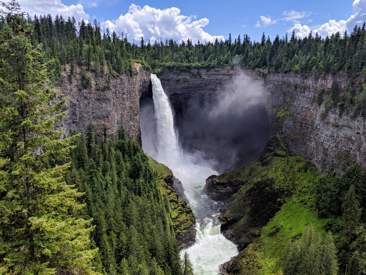
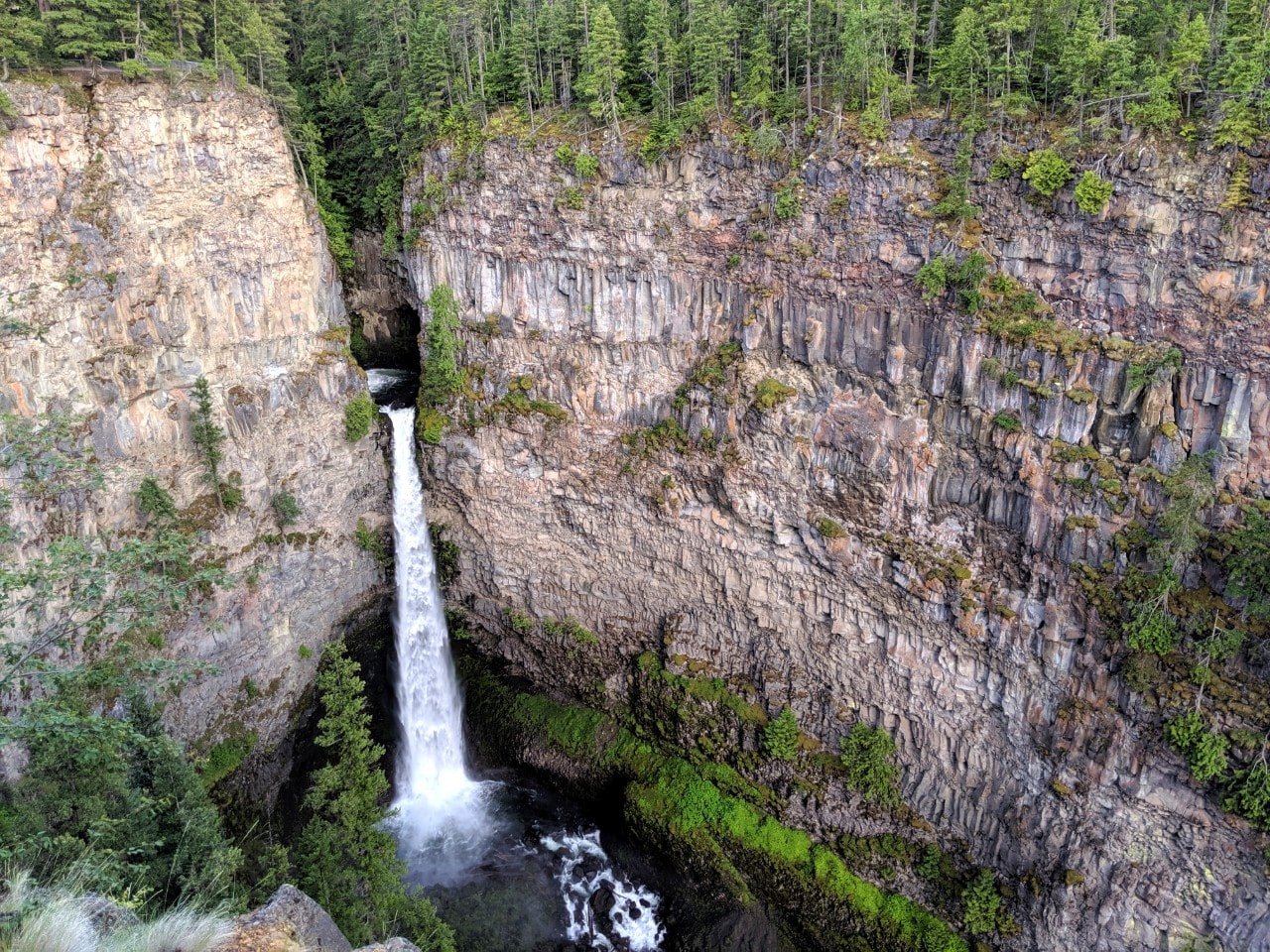
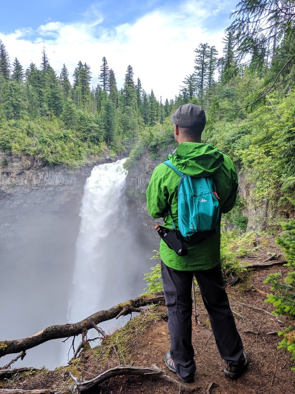
Helmcken Falls
Magnificent Helmcken Falls is the best-known waterfall in Wells Gray. The powerful 141m high waterfall plunges into a deep punchbowl.
The classic view of Helmcken Falls is found at kilometre 42 on the Wells Gray Corridor. There are several elevated wheelchair-accessible platforms located very close to the large parking lot (5 minutes walk).

For an alternative (and less crowded) perspective, hike the 4km (8km return) Helmcken Falls Rim Trail. Allow two hours or so to hike the almost completely flat trail along the Murtle River.
The reward is an up close and personal side view of Helmcken Falls, often accompanied by plenty of mist! Be careful, there is no fence here. Note that the trail can be pretty buggy in June and early July.
Trail length: 300m return (platform viewpoint) / 8km return (Rim Trail)
Difficulty level: Very easy / Moderately easy (due to length)
Time required: 10-20 minutes / 2 hours
Baileys Chute, Marcus Falls and Myanth Falls
For something a little different, consider the easy walk to Baileys Chute. This is where the Clearwater River narrows and becomes a series of rapids and small waterfalls.
When measured by peak flow rate, Baileys Chute is one of the largest waterfalls in BC. The power of this turbulent river is truly astounding!
From the parking lot (kilometre 56.8, unpaved access), the wide path first veers into the forest and then heads downhill to the river bank. There is a viewing platform with interpretive signage.

Baileys Chute is a popular place to watch the salmon run in September. While an impossible feat for the fish, it is fascinating (and moving!) to watch them fight their way through the rapids.
Spring is another great time to visit this Wells Gray waterfall as the river is even more powerful with the snow melt.
If you’re just after a short walk, turn around at Baileys Chute. Otherwise, continue along the riverside trail to see Marcus Falls (20 minutes further) and Myanth Falls (another 30 minutes from Marcus). Choose to finish the loop through the forest or return the same way.
Trail length: 1.6km return / 6.5km return
Difficulty level: Easy / Moderately easy (due to length)
Time required: 30 minutes / 2 hours

Osprey Falls and Stitca Falls
The last Wells Gray waterfall on this list is Osprey Falls. Situated very close to the end of the Corridor, this waterfall is short but extremely wide. It is the result of basalt flow from a nearby volcano blocking the outlet of the river.
The best place to see Osprey Falls is from the Clearwater Lake Campground. Park at the Chain Lake Meadows Trailhead just past the bridge over Falls Creek (kilometre 65.4) and follow the path into the campground.
A short trail between sites 19 and 21 leads to the riverbank and a view of the falls.
Another viewpoint can be found on the Chain Lake Meadows Trail (2.2km return trail), which also leads to Stitca Falls (another 600m return).
Trail length: 400m return / 2.2km return
Difficulty level: Easy / Moderate
Time required: 20 minutes / 1 hour 15 minutes

Bonus waterfalls: Triple Decker and Silvertip Falls
Still looking to chase more Wells Gray waterfalls? Triple Decker and Silvertip Falls are not in the park but are still worthy destinations for adventurous visitors.
As the name implies, Triple Decker features a three-tiered cascade set into a mossy canyon.
Good shoes are essential to hike the 1.6km return trail to the fall. It is very steep at times with loose surfaces (moderate level).
Triple Decker’s parking area is located pretty close to Clearwater. Look for some concrete barriers and a white Woodlot sign. There is some limited signage.
Silvertip Falls is situated on the way to the Trophy Meadows Trail, on the unpaved Spahats Creek FSR.
There is a Recreation Site campground at the same location. It is, however, very small so I would suggest parking on the road before the turn-off, especially if you’re in a larger vehicle.
The falls are 1.6km return from the campground and feature multiple cascades weaving through mossy rocks. It can be difficult to tell from the base but the estimated height of Silvertip Falls is 168m! Please note that the trail is very narrow and slippery.

Wells Gray Provincial Park: Trip planning essentials
Keep the following information in mind when planning your Wells Gray waterfall adventure.
When to go
Wells Gray Provincial Park is usually open year round although facilities and road access are limited from October to April.
The best time to visit to see the Wells Gray’s waterfalls is May and June when the flow is the strongest (spring melt). It can, however, be quite buggy. Take precautions!
July and August are also great months to visit but the waterfalls are less strong.
The weather is generally warmer at this time and the mist from the waterfalls can be refreshing. The bugs are usually less ferocious by mid-August (weather dependent)
The summer months are also the busiest time for visitation, though Wells Gray isn’t nearly as popular as other destinations such as Banff and Jasper National Parks.
September is another good month to go. While the waterfalls are usually in their lowest flow during the first part of the month, they are still spectacular to look at.
The salmon start to migrate along Baileys Chute in September. The sight of the salmon trying to leap up the rapids is an impressive spectacle to witness. The park also features some beautiful autumn colours towards the end of the the month.

How to get to Wells Gray
Wells Gray Provincial Park is located in British Columbia in Western Canada.
More specifically, the park occupies a large wilderness area north of Clearwater, west of Valemount and east of Williams Lake.
The main park access is via the Wells Gray Corridor, a 68km route providing access to waterfalls, campgrounds, hiking trails and lakes. The Corridor starts just north of Clearwater, a small community of 2,500 people.
Not familiar with BC? Clearwater is 480km (300 miles) northwest of Vancouver, about a five-hour drive.
From Calgary, the drive is a little longer. The distance is 726km (450 miles) and takes around 8 hours without stops.
Wells Gray is a popular place to visit on a Canadian Rockies loop road trip or while travelling from Vancouver to Calgary via Jasper.

Organising your day
Driving the Wells Gray Corridor from Clearwater to Helmcken Falls takes around 45 minutes (46km). So a return journey without any stops takes around 1.5 hours plus time at the falls.
Just dropping into Wells Gray and not looking to hike much? In 3 hours (from Clearwater), most visitors have time to visit:
- Spahats Creek Falls
- Dawson Falls (+ roadside Mushbowl)
- Helmcken Falls
Visitors with more time (4-5 hours) will likely be able to check out:
- Spahats Creek Falls
- Dawson Falls (+ roadside Mushbowl)
- Helmcken Falls
- Ray Farm (no waterfalls)
- Bailey’s Chute
If hiking is an option, my top pick for a 4-5 hour itinerary would be (in time order):
- Moul Falls
- Dawson Falls (+ roadside Mushbowl)
- Helmcken Falls
- Bailey’s Chute
- Spahats Creek Falls
Staying overnight in the park? I would suggest following this itinerary instead:
Day 1
- Moul Falls
- Dawson Falls (+ roadside Mushbowl)
- Helmcken Falls
- Bailey’s Chute, Marcus Falls and Myanth Falls
- Osprey Falls
Day 2
- Ray Farm (no waterfalls)
- Helmcken Falls Rim Trail
- Spahats Creek Falls
If you have a reliable, high-clearance vehicle and some extra time, consider hiking the beautiful Trophy Meadows Trail (no waterfalls but beautiful sub-alpine scenery).

What to bring
- Be sure to bring your mosquito repellent of choice and consider wearing long sleeves (and even pants) on forested hiking trails when visiting in spring
- Food and water! Wells Gray Provincial Park has only one place to buy meals and snacks – the Osprey Cafe at Clearwater Lake (end of the Corridor). It is open seasonally only
- On the longer hiking trails, I’d recommend carrying bear spray (in an easily accessible place) and knowing how to use it. At the very least, you should know what to do if you see a bear
- Appropriate footwear is essential on the longer trails, especially after rain
- Dogs are allowed in Wells Gray but must be on a leash at all times
- Wells Gray Provincial Park is free to enter with no park pass or admission required (unlike Canada’s national parks)
How to stay safe
There is very little phone signal in Wells Gray Provincial Park. Tell someone where you’re going and when you plan to be back.
Some paths can be muddy after rain, even the morning after. Wear appropriate footwear.
Stay on marked trails and remain alert for wildlife. Make noise to alert animals of your presence.
If you do see wildlife, be sure to give them plenty of space. Do not approach, follow, scare or feed animals.
Never get out of your vehicle to get closer to an animal! Bears, for example, can move a lot faster than you probably expect.
Please pack out all of your trash with you to help keep Wells Gray Provincial Park beautiful.

Where to stay in Wells Gray Provincial Park
Camping is the only way to stay in Wells Gray Provincial Park overnight.
There are three vehicle-accessible campgrounds in this area of the park, with sites priced at $20-23/night.
Set in a thick forest, Pyramid Campground is situated very close to Helmcken Falls (paved access).
There are 50 well-spaced unserviced campsites in this campground, all offered on a first-come, first-serve system only. A hiking trail leads to an alternative view of Dawson Falls.

Falls Creek and Clearwater Lake Campground are located very close to the end of the Wells Gray Corridor (unpaved access), within walking distance of Osprey Falls.
There are 40 reservable campsites in each campground, all close to the river. The campgrounds share coin-operated shower facilities.
In my opinion, Pyramid is more conveniently located for exploring waterfalls and hiking trails while Falls Creek and Clearwater Lake are better for water-oriented visitors.
The Wells Gray Corridor is surrounded by expansive backcountry areas with numerous camping opportunities accessed by water or hiking trails.
The Sheila Lake backcountry campground in Trophy Meadows is one of the best anywhere in BC.

Other accommodation options near Wells Gray Provincial Park
Though there may not be any non-camping accommodation in Wells Gray Provincial Park itself, there are several lodges, inns and B&Bs located along the Wells Gray Corridor.
Wolfwood Guest Ranch boasts four heritage cabins, one of which is nearly a century old. Each cabin accommodates 2-5 adults and complimentary breakfast is available.
Just a short distance away is Battle Creek Ranch. The welcoming hosts (one of whom speaks German) provide accommodation in two comfortable suites on their farm.
Across the Creek Cabins is close to Moul Falls. The property features several fully equipped individual cabins set in a forest.
Nearer to Clearwater, there’s an even bigger choice of B&Bs, inns and motels. One of them, Grizzly Paw B&B, even has a waterfall in walking distance.
As for hotels, the Best Western Plus Gateway to the Falls in Clearwater takes the lead. Within each reach of the Gateway Grill and Wild Flour Bakery, this property is an excellent choice for a comfortable stay after a day of exploring the park.
Explore more of British Columbia:
18+ Best Things to Do in Revelstoke, British Columbia
The Best Hot Springs in BC: Complete Guide + Map
Ultimate 2 Week Western Canada Road Trip from Vancouver: Itinerary, Tips & Map
32+ of the Best Beaches in British Columbia
Where to See the Salmon Run in British Columbia


One half of the Canadian/British couple behind Off Track Travel, Canada. Jean Robert (JR) is up for anything, but you’re most likely to find him either snowboarding, fishing or building something. Gemma and JR are currently based in the beautiful Okanagan Valley, British Columbia, Canada.