There’s something really quite special about hiking on the West Coast of Vancouver Island.
Besides the outstanding natural beauty (ancient temperate rainforest, golden sand beaches, misty mountains, windswept islands and more), there’s a distinctive atmosphere that is hard to find anywhere else.
I’m not sure whether it is the humidity, the intermittent fog, the relative remoteness or the ever present rolling ocean waves, but hiking here always feels more intimate somehow.
One of the most accessible places to experience this yourself is in the area around Tofino, a small town perched on the edge of Clayoquot Sound.

Read on to discover 11 tried and tested short Tofino hikes that share the magic of Vancouver Island’s West Coast.
Many of the places and trails mentioned in this post are located on traditional territory of the Nuu-chah-nulth people. Please hike responsibility and always follow Leave No Trace ethics.
Backcountry necessities
- Always bring the 10 Essentials
- Know how to stay safe in the backcountry
- Remember to Leave No Trace to help keep the wilderness wild
- Understand how to avoid negative bear encounters
- Trying out backpacking for the first time? Read Backpacking 101
- Check out our packing guide with gear recommendations
- Sign up to our newsletter for a free backpacking checklist

11 of the best Tofino hiking trails
The first six Tofino hikes listed below are easy to access and also suitable for most people with average fitness.
The following three are for more adventurous hikers who want to get off the beaten path and try something a little more challenging.
The final Tofino hikes are two very short, low difficulty trails that are ideal to do on the way to (or from) Tofino.
With four extended trips to Tofino under our belts (so far), we have tried these trails multiple times and in varying seasons and weather conditions.
All offer something a little different and unique that I believe will enhance your Tofino hiking experience. Happy hiking!
This post includes some affiliate links. If you click through these links and make a qualifying purchase, I may receive a small commission at no extra cost to you.

6 quintessential Tofino hikes
These easy, fast and fun Tofino hiking trails offer a great overall perspective of the region. Do one, do them all.
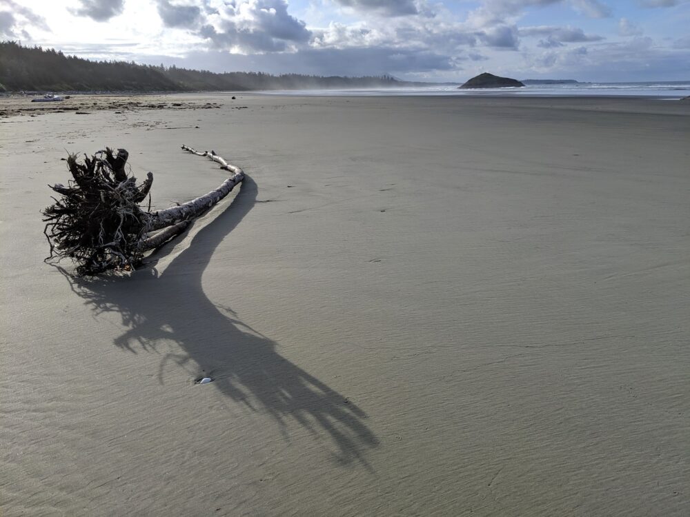
Rainforest
To experience the classic temperate rainforest experience that Pacific Rim National Park is so well known for, look no further than the Rainforest trail.
The name may be self explanatory, yet the rewards are still significant; think huge cathedral-like trees, hanging moss, a carpet of ferns and soft mosses.

The foliage is so thick that it is often hard to see the ground on this Tofino hike. The elevated boardwalk (with stairs) makes it easy to admire it all.
There are actually two trails to choose from, with one hike located on the north (loop A) side of the highway and another on the south (loop B). If you can, take the time and do both.
Trail length: Two 1km loops (20 minutes for each)
Trail location: Pacific Rim National Park, 23.7km from Tofino

Shorepine Bog
For a Tofino hiking experience with a twist, check out the short but surprisingly rewarding Shorepine Bog trail.
This completely flat boardwalk trail travels through swamp terrain and features a diverse mix of mosses, lichens, medicinal plants and twisting, almost bonsai-like Shore Pine trees.
The acidic soil here stunts growth so much that some of these squat trees are actually much older than you’d think. Some have been here for over 300 years.

The Shorepine Bog trail may not have dramatic views of the Pacific ocean or gargantuan trees to admire but we always find it fascinating to see a strikingly different ecosystem within Pacific Rim National Park.
Due to the flat boardwalk surface, this Tofino hike is also very wheelchair and stroller friendly.
Trail length: 800m loop (20 minutes)
Trail location: Pacific Rim National Park, 29.4km south of Tofino

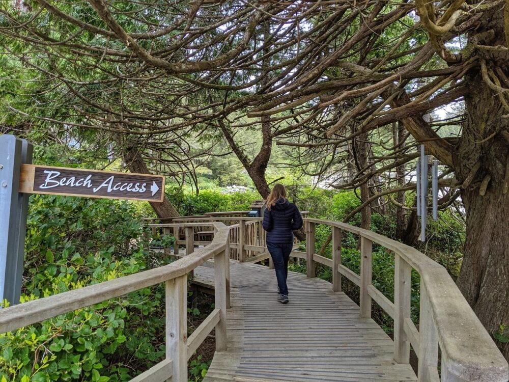
Nuu-chah-nulth (with South Beach extension)
Nuu-chah-nulth means “all along the mountains and sea” and refers to fourteen separate but related First Nations on the west coast of Vancouver Island.
This Tofino hiking trail offers a chance to learn more about Nuu-chah-nulth history and culture, while hiking in the forest between two gorgeous beaches. Look for the interpretive signage and totem poles and check out the panoramic coastal views.
This Tofino hike was formerly known as the Wickaninnish trail and has two trailheads – one at the Kwisitis Visitor Centre and another at Florencia Bay.

The South Beach trail branches from the eastern side of the Nuu-chah-nulth. It leads to a couple of isolated small coves that are ideal for watching the Pacific Ocean crash onto the rocks.
If short on time (or you’d prefer to avoid the 200+ stairs on the main part of the trail), consider starting the at the Kwisitis trailhead and taking the South Beach branch and then returning the same way. The excellent Kwisitis Visitor Centre, by the way, is worth a stop before or after your hike.
Trail length: 6.8km return (2 – 2.5 hours)
Trail location: Pacific Rim National Park, 30km south of Tofino

Tonquin Trail
The Tonquin Trail was one of our favourite finds on our most recent trip to the West Coast.
Located close to town, this Tofino hike hugs the coastline, offering fantastic elevated viewpoints of crashing waves, nearby islands and the horizon beyond.
The trail also winds down to several sandy beaches, where it is possible to examine rock pools. There are multiple sets of stairs and also some short steep sections.

If you feel like a longer hike or want to complete a full loop, it is possible to continue beyond Middle Beach south to Mackenzie Beach and then along Hellesen Drive to the main highway.
From here, you can either continue on the Multi-Use Path all the way to Tofino or link up with the Tonquin Trail connector at the end of Industrial Way.
Trail length: Variable routes, 1-3km or more
Trail location: Main trailheads are located on Tonquin Park Road and the Community Hall, just west of downtown Tofino

Schooner Cove [currently closed]
Undoubtedly one of the most popular hikes in the area, Schooner Cove showcases the lush temperate rainforest and spectacular beach combination that so epitomises Pacific Rim National Park.
The boardwalk is lined by soaring hemlock and cedar trees, hanging vines and cushiony moss. As you descend each step of stairs and cross several creeks, the sound of rolling waves gets louder.

The boardwalk leads right out onto an expansive sandy beach, with a rocky outcrop just ahead. Schooner Cove is actually part of Long Beach, Pacific Rim’s flagship beach.
From here, it is possible to walk as far as 16km (!!) to the Kwisitis Visitor Centre on the eastern side. If you do, be careful to keep an eye on the tides as the water level can change quite quickly.
Trail length: 2km return (45 minutes with some time on the beach)
Trail location: Pacific Rim National Park, 15.4km south of Tofino

Downtown Tofino
For a fuller picture of Tofino, consider taking an afternoon to explore the downtown area by foot. There are historical and cultural interpretive signs and artifacts dotted around the town, which are easy to miss when you’re not actively looking for them!

For an ever better insight, consider joining a walking tour, led by a local guide.
Our two hour journey around downtown Tofino brought us beyond the beautiful Clayoquot Sound views, hip coffee shops, famed food trucks and surfer spots to learn more about the Nuu-chah-nulth people (the first inhabitants of this area) as well as the European settlers.
This would be an ideal tour to any first time visitor to Tofino, especially hikers who will be spending time exploring traditional Nuu-chah-nulth territory.

Tofino hikes for the more adventurous
The following Tofino hiking trails are a little further off the beaten path. Consequently, they are all a little more rough and rugged than the Tofino hikes listed above, and extra caution and effort is required. I have included basic directions as well as specific cautionary information where necessary.
Big Tree Trail
The Big Tree Trail leads through a beautiful grove of old growth trees on Meares Island, just across the water from Tofino’s harbour.
Prepare to be humbled as you hike on an axe hewn boardwalk with huge, gnarled statuesque trees towering above.
One of our highlights was the ‘Hanging Garden Tree,’ a Western Red Cedar more than 1000 years old and home to over 15 other species of plants and trees. It’s an awe inspiring sight.

This special place would have actually been destroyed in 1984, after the British Columbia government gave permission to a logging company to clear-cut 90% of Meares Island. It wasn’t their land to offer, however.
The local Tla-o-qui-aht and Ahousaht First Nation people protested and set up a blockade, the first steps to the area becoming protected as the Tribal Park it is today.
We visited Meares Island with a Tla-o-qui-aht owned business that is sadly no longer operating (2025 update).
Our guide Thomas (also known as Mouatch mit, meaning ‘son of deer’), shared a wealth of knowledge about the Tla-o-qui-aht people and Meares Island, including traditional songs, stories, medicinal plants, cedar tree harvesting techniques and more.
Trail length: 2.4km return hike to the Hanging Garden Tree on boardwalk, 4.2km loop trail alternative with boardwalk and dirt trail (1 – 2 hours)
Trail directions: The Big Tree Trail is located on Meares Island, a Tla-o-qui-aht Tribal Park. Hikers can choose between renting kayaks, hiring a water taxi (10 minute journey from Tofino) or joining a tour to reach the Big Tree trailhead.

Cox Bay Lookout
Those who love short ‘n’ steep yet rewarding trails should put the Cox Bay Lookout to the top of their Tofino hiking list.
The uphill and somewhat gnarly climb (about 120m elevation gain) is more than worth the effort to see breathtaking views of Cox Bay, Clayoquot Sound, the Pacific Ocean and dozens of Vancouver Island peaks.
Popular with locals as a training hike and sunset watching spot, the challenging part of the Cox Bay Lookout hike only lasts around 15-20 minutes.

There are no views at all until the path reaches above the trees. Just a few minutes further from the first viewpoint above Cox Bay is another rocky outcrop with epic panoramas to the north and west.
Please note – this is not an official Tofino hiking trail. There is no official maintenance or markings on the route. Prepare for spontaneous route finding, plenty of mud, slippery roots and some rock scrambling near the top. There was a rope for assistance on our visit, but don’t assume it will be safe to use.

Trail length: Approximately 3.5km return from Maltby Road parking lot (1 – 1.5 hours)
Trail directions: This hike can be hard to find as it is not marked and has multiple potential trailheads. Head to the very southern end of Cox Bay beach at low tide and look above the north-facing rocks. There are a handful of different paths that travel up from the beach between the rocks. These eventually connect in the trees before the steep climbing section starts.

Canso Plane Crash Site
This muddy hike offers the unique chance to see a crashed WWII bomber plane.
On February 10th 1945, the Royal Canadian Air Force Canso 11007 experienced engine failure shortly after takeoff from Tofino. Quite remarkably, all 12 crew members survived the crash, despite the plane carrying 400kg of bombs on board.
The Canso plane still sits where it landed over 70 years ago, with warped wreckage and metal fragments spread around the site. The main body of the plane is still very recognisable and a fascinating insight into the wartime era.

While this trail is not technically difficult (it is mostly flat), can be very muddy as the plane is situated at the edge of a bog. This is true all year round. Boardwalk sections have been added in recent years.
Even so, I’d still recommend bringing a hiking pole to assist with balance and clothes you don’t mind getting muddy.
Trail length: 4km return (around 2 hours)
Trail directions: Park at the first parking lot on Radar Hill Road in Pacific Rim National Park and then walk 950m south-east along the multi-use trail (away from Tofino). Turn right onto Canso Plane Crash trail at the junction. Please note that there is no signage as it is not a Parks Canada promoted hiking trail.

Must do hiking trails on the way to Tofino
The majority of visitors to Tofino travel from Vancouver Island’s eastern coast via Port Alberni. Start or end your Tofino trip with one of these fast and fun hikes located close to the highway.
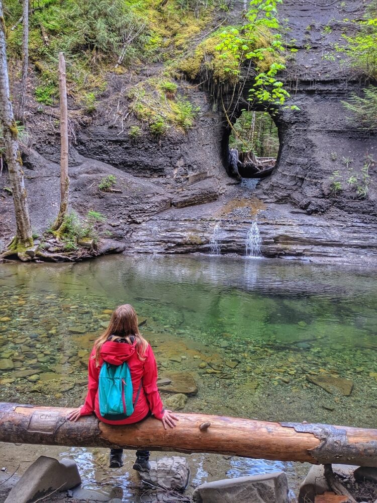
Hole in the Wall
This trail proves that man made spots can be great hiking destinations too. The ‘hole in the wall’ in question was actually a shortcut created for Port Alberni’s water pipeline back in the 1960’s. It is now the site of a picture perfect waterfall, cascading into a creek surrounded by second growth rainforest.
Trail length: 1.3km return (30 minutes)
Trail location: The Hole in the Wall is easily accessed via a 15 minute walk from Highway 4. Park in the pull-off opposite Coombs Country Candy and follow the signs down the gravel path. Due to the parking location, the Hole in the Wall is best visited on your way back from Tofino (i.e. from the west).

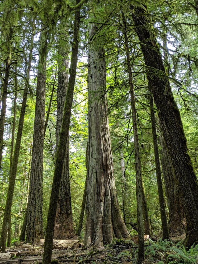
Cathedral Grove
A classic stop on any West Coast bound road trip, Cathedral Grove offers a chance to explore a beautiful section of old growth rainforest that was once so common on Vancouver Island.
The canopy here is up to 80m high. There are multiple short looping walking trails around the forest, including one passing an incredible 800 year old Douglas Fir tree with a circumference of over 9 metres.

Trail length: Three 1km – 2km loop trails (20 – 45 minutes)
Trail location: Located between Port Alberni and Coombs on Highway 4, Cathedral Grove can be an exceptionally busy place at peak visiting times (10am – 4pm). If parking proves difficult on your journey to Tofino, don’t worry. There’s another chance on the way back.
Tofino hiking: What you need to know
- As with any hike and outdoor adventure, it is vital to leave any destination or trail better than you found it. Stay on designated trails to reduce damage, pack out all your trash, do not pick up or take away any natural objects
- Wear appropriate footwear. Tofino’s hiking trails can be slippery, rocky, uneven and muddy. Sturdy, waterproof hiking shoes with good tread are ideal for hiking around Tofino (we love our Oboz hikers)
- Bring food, water and extra clothing on every hike. Yes, the Tofino hiking trails listed here are all relatively short in length but it is so important to be prepared for changing conditions and unexpected delays. Read more about why you should bring the 10 Essentials on every hike here
- Do not drink water from streams and rivers without filtration or purification. This is true no matter how clear or safe the water may look! It is impossible to know whether the water has been contaminated by parasites. We carry a BeFree filter on longer hikes
- For your own safety, keep to designated trails and official viewpoints only. The Pacific Ocean is undoubtedly one of the main attractions when hiking near Tofino, but it can also be dangerous
- Check the weather forecast before heading out on your Tofino hike. Heavy rain can make boardwalks slippery and high winds can cause huge waves
- A Discovery Pass or day ticket is required to access hiking trails in Pacific Rim National Park

Local wildlife
- There is the possibility to see deer, black bears, bald eagles and raccoons while on these Tofino hikes. Cougars and wolves are also present but are rarely seen. In the water, you may spot harbour seals, sea otters, herons, orcas, humpbacks and gray whales
- Always observe wildlife from a distance and do not approach. If they approach you, give them space to pass or escape
- Never, ever feed wild animals. Doing so effectively kills the animal as they will lose their fear of humans
- Worried about bears while hiking around Tofino? The best thing to do is actively try to avoid an encounter. Make noise, travel in groups and stay alert. Bears generally do not want to be around humans. Carrying bear spray can be helpful in the (extremely) unlikely event of an attack
Thank you to Tourism Tofino and Tofino Food Tours who assisted with our trip to Vancouver Island’s West Coast and enabled us to do so many Tofino hikes!
You may also like to read:
How to Find Big Trees on Vancouver Island, BC
Hiking to Canada’s highest waterfall, Della Falls
Three off the beaten path road trips on Vancouver Island


Check out these other hiking posts next

One half of the Canadian/British couple behind Off Track Travel, Gemma is happiest when hiking on the trail or planning the next big travel adventure. JR and Gemma are currently based in the beautiful Okanagan Valley, British Columbia, Canada. Consider buying us a coffee if you have find any of our guides helpful!
The Big Tree Trail was superb. Exactly what I imagined a northern hemisphere rainforest to be. Thank you for steering me to it and a huge thank you to the Tla-o-qui-aht and Ahousaht First Nations for allowing me to hike it. I did the 4.2 km loop. The boat taxi owner told us it would be muddy. It was, and then some. Worth every penny though.
Wonderful to hear! I’m so glad you liked it Judy!