Okanagan Lake is the centerpiece of BC’s beautiful Okanagan Valley. And around two thirds of the way down this 135km long lake is the rugged and mountainous Okanagan Mountain Park.
Living on the northern side of Penticton, we feel fortunate to be able to see the craggy peaks of Okanagan Mountain every day.
Yet despite this prominence in the Valley, Okanagan Mountain Park is not remarkably popular to visit. This is partly due to its limited access. The backcountry focus of the hiking trails and campgrounds is also a factor.
During the pandemic, we made it a priority to discover more of this magnificent park located in our backyard.
This post will showcase the hiking and paddling opportunities in Okanagan Mountain Park, including trail and campsite details, plus tips and advice on the best time to go.

Backcountry necessities
- Always bring the 10 Essentials
- Know how to stay safe in the backcountry
- Remember to Leave No Trace to help keep the wilderness wild
- Understand how to avoid negative bear encounters
- Trying out backpacking for the first time? Read Backpacking 101
- Check out our packing guide with gear recommendations
- Sign up to our newsletter for a free backpacking checklist

About Okanagan Mountain Provincial Park
At 11,038 hectares, Okanagan Mountain Park is one of the largest provincial parks in British Columbia’s interior region. It sits opposite Peachland and between Kelowna and Naramata, on the eastern shore of Okanagan Lake.
Established in 1973, the park is a representative example of the Okanagan Basin and Okanagan Highlands, with three different biogeoclimatic zones – bunchgrass, ponderosa pine and interior Douglas fir.
Humans have been visiting Okanagan Mountain Park for thousands of years. Here are some notable events and uses:

Syilx First Nation
Okanagan Mountain Provincial Park has been visited by humans for thousands of years. According to BC Parks, Wild Horse Canyon was used as a wild-horse trap by the Syilx. Pictographs have been found on rock outcrops and canyon walls.
Pandosy Mission
Father Charles Pandosy was one of the first European settlers in the Okanagan Valley, establishing a mission in Kelowna in 1859. Some of the existing trails in the park (such as Wild Horse Canyon) are based on settler routes.

WWII
Commando Bay, now a location of a marine campground, was used during WWII to secretly train Chinese-Canadians for guerilla warfare.
Goode’s Creek, another marine campground location, was named after Dave Good. He was a supplier of survey crews for the Kettle Valley Railway (KVR), which passes close to the eastern park borders.
1950 Canadian Pacific Air DC-3 crash
In December 1950, a plane crashed close to Divide Lake. The two pilots died. The rescue story of the surviving passengers is quite extraordinary. There are still a few remnants from the crash around but there is no official trail access.

Rattlesnake Island
This tiny island just offshore from the main part of Okanagan Mountain Park used to be owned by Eddie Haymour, who wanted to transform Rattlesnake Island into a Arab-themed tourist attraction.
What happened next is a fascinating, but sad, story involving international governments, hostages and financial ruin. To read the full story, click the link below.
Read Next: Rattlesnake Island, British Columbia: Small Island, Dramatic History
2003 wildfire
In August 2003 a wildfire started by lightning strike close to Rattlesnake Island. Exceptionally dry summer conditions and constant winds caused the wildfire to spread quickly and become a 250 square kilometre-sized firestorm. Most of the trees in Okanagan Mountain Park were burned. There have been other, smaller, wildfires since such as the 2018 Goode’s Creek fire.
How to access Okanagan Mountain Park
The park has four main access points, in addition to the 33km long Okanagan Lake shoreline:
- North Parking Lot on Lakeshore Drive, Kelowna
- Golden Mile Trailhead on Lakeshore Drive, Kelowna
- Rimrock Gate on Timberline Road, Kelowna
- South Parking Lot, just off Chute Lake Road, near Chute Lake

North Parking Lot has a dedicated parking lot, outhouse and kiosk with park map. It is the main entrance of the park for visitors from the Kelowna area.
Golden Mile Trailhead is located 1.8km west of the North Parking Lot. It is marked by a red gate. There is space two vehicles to park by the side of the road.
Rimrock Gate is mainly used to access the service road that leads to Divide Lake. On-street parking only (be careful not to block any driveways).
South Parking Lot has an outhouse, kiosk, picnic tables and fire rings. The 2km access road is narrow and rough in places, with scratchy, overgrown foliage. I’d recommend using a high clearance vehicle with good tires.

Important things to know
There are some notable hazards in Okanagan Mountain Park.
Wilderness location
Please note that while most of Okanagan Mountain Park is within phone range, it is still classed as a wilderness area and rescue is still a potentially lengthy process.
Exposure
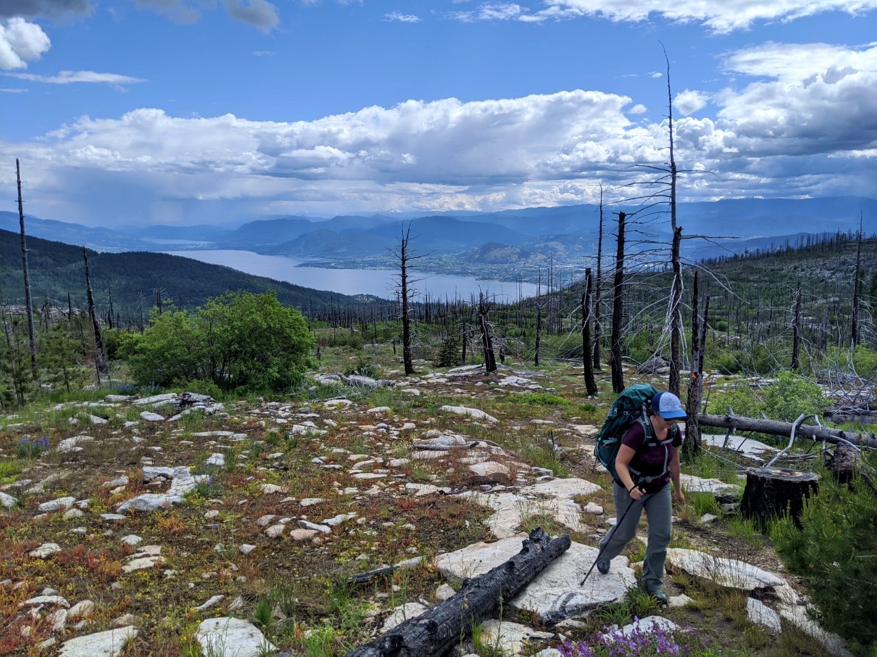
As a result of wildfires (more info below), Okanagan Mountain Park doesn’t have a lot of trees.
For this reason, there is very little shade and exposure can be a real concern. Temperatures regularly top 30-35c in the summer. To compound this issue, there are very few water sources in the park besides the lakes.
For these reasons, I do not personally hike in Okanagan Mountain Park in July and August.
If you choose to, be sure to bring plenty of drinking water (at least 2L per person in the summer), a sunhat and sunscreen. Long sleeves with SPF protection are a good idea to prevent sunburn.

Wildlife
Northern Pacific rattlesnakes, BC’s only truly venomous snake, are found in the park. They are not considered to be aggressive but can be dangerous if threatened.
It is a good idea to:
- Keep pets leashed
- Avoid putting your hands and feet in places you can’t see
- Don’t pick up items below which a snake may hide (e.g. wood)
- and keep a 3 meter distance if you do see one
Other reptiles also live in the park, as well as coyote, mountain goats, deer, elk, lynx and even moose. Bears are rarely seen but it’s still important to be bear aware.
Ticks
Mosquitoes and ticks can be a pest, particularly in the interior. This was especially true when we visited in early June one year – the mosquitoes were absolutely ferocious! I also picked off two dozen ticks while hiking the Mountain Goat Trail.
- Wear light coloured long-sleeved shirts and pants to make it easier to spot ticks
- Stay on the path whenever possible and avoid long grassy areas
- Use bug spray containing DEET or Icaridin
- Be sure to perform a tick check after visiting the park during the warmer months
- If heading to Okanagan Mountain Park on an overnight trip, double check you have a tick remover or tweezers in your first aid kit!
Read more tick advice from the Government of Canada

Wildfire dangers
As mentioned above, Okanagan Mountain Park was burned by a huge wildfire in 2003. The effects of this fire can still be seen today, with burned tree stumps and charred trees a common sight.
Deadfall remains an obstacle in some places. Tree limbs may fall in windy weather. BC Parks recommends hikes to wait for favourable weather, with the risk being lower on calm days with no rain or snowfall. When windy, the advice is to:
- Travel quickly to reduce exposure time
- Spread your group out to reduce risk of multiple casualties
- If trees are actively falling, leave the area or take shelter
Campfires are still allowed at Okanagan Mountain Park’s campgrounds (when there is no fire ban, of course), but in fire rings only. Be sure that your campfire is out and cool to the touch before leaving it unattended.

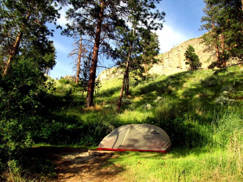
Camping in Okanagan Mountain Park
With the exception of one ‘frontcountry’ campground, all of the camping opportunities in Okanagan Mountain Park are located in the backcountry.
The ‘frontcountry’ campground is in the South Parking Lot, where vehicle and tent camping is allowed. There is a grassy area just beyond the parking lot with an outhouse, two picnic tables, two fire rings and space for two tents. There is no fee.
I say frontcountry loosely as the camping facilities offered here are more rustic and less organised than a regular vehicle accessible provincial park campground.
There are seven marine campgrounds on the shore of Okanagan Lake. As well as being accessible by boat, three of these campgrounds are connected to the Wild Horse Canyon hiking trail and therefore also reachable by foot.
In the interior of the park, there is two campgrounds accessible by hiking trails only – Baker Lake and Divide Lake.
All Okanagan Mountain Park campgrounds are open year-round.

Hiking in Okanagan Mountain Park
There are over a dozen hiking trails in Okanagan Mountain Park, many of which are interconnected to provide access to backcountry campgrounds, trailheads and viewpoints.
Some of the hiking trails in Okanagan Mountain Park can also be cycled (responsible cycling etiquette required), with the Wild Horse Canyon being a popular choice.
Please note that some of the trails are quite overgrown and may require some trail finding to follow. Poison ivy is present in areas.
For hiking trail navigation (besides a map), I’d suggest using the free app Maps.me. If you download the maps in advance, you can use them offline.

Hiking trails
The full list of trails in Okanagan Mountain Park can be found on the BC Parks website, as well as a map. The three most popular trails are (all distances one way):
Wild Horse Canyon – 27km, 625m elevation gain
The Wild Horse Canyon Trail is a amalgamation of other hiking trails and skirts the periphery of the park. This makes it a great low elevation option for spring hiking.
Most hikers start this trail from the North Parking Lot on Lakeshore Road. It starts with a steady uphill climb, revealing views of Okanagan Lake. Into the canyon, the trail is lined by steep granite. Swampy sections follow.
Most of the elevation gain noted above is experienced at the southern end. If day hiking, feel free to turn around at any point.
The longest route in the park, the Wild Horse Canyon Trail can be combined with other trails to create a 2-3 day backpacking loop
One loop would be Wild Horse Canyon Trail (17km), Frederick Creek to Baker Lake (4km), Baker Lake to Divide Lake (2km), Divide Lake Trail (7km), C.N Trail/Wild Horse Canyon Trail (3km).
Buchan Bay, Commando Bay and Goode’s Creek are campground options.
Mountain Goat Trail – 5km, 550m elevation gain
Starting from the South Parking Lot, the Mountain Goat Trail climbs through the forest before reaching the classically rugged landscape of Okanagan Mountain Park.
Views appear of Okanagan Lake, Summerland and Penticton as the trail climbs higher and through patches of wildflowers. The meandering route intersects several (usually dry) creeks. This short but challenging trail ends just south of Divide Lake, where there is a backcountry camping.
A side trail leads to the top of 1576m high Okanagan Mountain, where there is a number of communication towers and some lovely (if, a little obscured) 360 degree panoramas.

Divide Lake Trail – 9.5km, 950m elevation gain
The Divide Lake Trail follows a service road all the way to Divide Lake and onto the Okanagan Mountain peak (as described above). It’s not the most interesting trail for this reason but there are views of Kelowna and Okanagan Lake almost throughout.
The continuous uphill grade of the route is challenging, which means it is an excellent trail to train on during the spring.
Trail distance listed above is from the Rimrock Gate. It is also possible to start at the North Parking Lot and hike the Wild Horse Canyon/C.N Trail (3km) until it intersects with the Divide Lake Trail.
When to go
The best time to hike Okanagan Mountain Park is from May, June, September and October. The weather is usually warm, but not too hot. The snow is gone and the trails are dry. In spring, the trails are bordered by beautiful wildflowers.
It’s also possible to hike in July and August but the heat can make the experience uncomfortable and and even dangerous. There is very little shade in the park and few sources of water besides the lakes.
While the lakeshore is snow-free almost all year round, the mountains of the park’s interior are usually covered with snow from November to April.

Backcountry campsites
Baker Lake and Divide Lake both have backcountry campgrounds for hikers.
Divide Lake is a long, narrow lake located behind Okanagan Mountain (1571m). The rustic campground is 8-10m above the actual lake but it is possible to access the shore. There is an outhouse, old cabin, picnic table and fire ring.
Baker Lake is on the other side of Okanagan Mountain and has a smaller campground with an outhouse and fire ring.
Fees and permits
There are no fees or permits to camp at Divide Lake or Baker Lake. With no reservation system, campsites work on a first come first serve system.

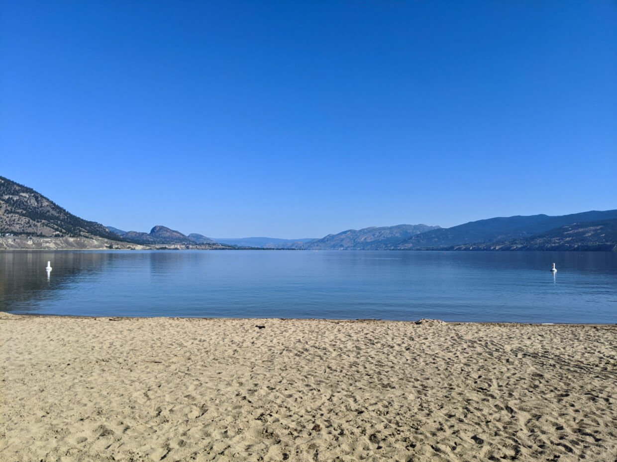
Paddling Okanagan Mountain Park
Okanagan Mountain Park is an ideal destination for a multi-day kayak or canoe trip. Despite being located across from Highway 97, the undeveloped shoreline (33km long) of the park feels surprisingly remote at times.
The scenery is also spectacular, with tall cliffs rising straight out of the water to form the rugged mountains this park is so well know for. The rugged lakeshore is also punctuated with pretty beaches, which provide numerous places to stop and even camp overnight.

Visiting during the shoulder seasons (when less motorised boats are on the water) offers the best chance to see wildlife by the lake. We’ve personally seen large herds of mountain goats navigating the cliffs above the water, as well as deer and bald eagles.
Another highlight is the chance to visit Rattlesnake Island. This tiny place was once the cause of a international incident and is now home to a half finished miniature golf course. Intrigued? Read this post first and visit for yourself!

When to go
The best time to paddle Okanagan Mountain Park is from April to October.
July and August are hot, making it the perfect time to swim in the lake. It is also the most popular time for motorised boats, however.
The shoulder seasons can often have periods of surprisingly calm conditions, though the water is cold. We like to go in May or June, when few boats are on the lake and the weather is still warm.
Okanagan Lake does not freeze in winter, though the shoreline can become icy during the coldest months of January and February.

Rattlesnake Island
Visiting Rattlesnake Island is a definite highlight of paddling Okanagan Mountain Park. This tiny island has a surprisingly interesting history and is a fun place to spend an hour or two. The views from Rattlesnake Island are also spectacular!
Rattlesnake Island is located 4km north from Buchan Bay and less than 2km south from Halfway Bay. The campground at Reluctant Dragon Cove is a very short paddle away.

Backcountry campsites
Okanagan Mountain Park has seven marine campgrounds (listed in order from south to north):
- Van Hyce Beach: Open site facing north-west with two different beaches
- Goode’s Creek: Shaded site set into the woods with a hiking trailhead
- Commando Bay: Lovely beach with protected camping area behind it. There is a hiking trail here
- Buchan Bay: Smaller, but still nice, beach with space for tents above and behind. There is also a hiking trail
- Reluctant Dragon Cove: Long beach with a rocky headland, very close to Rattlesnake island
- Halfway Bay: Multiple small tent sites behind narrow but long beach, rocky headland
- Halfway Point: Small sheltered beach located at exact halfway mark between Penticton and Kelowna

We have visited five of these marine campgrounds personally – all but Halfway Bay and Halfway Point.
All campgrounds have a BC Park sign, at least one picnic bench (often two), with at least one fire ring (sometimes two) and an outhouse.
Of those we have visited, my favourites are Commando Bay and Buchan Bay. Reluctant Dragon Cove comes in third.

There is usually space for a small number of tents at each campground (2-3).
Please note that the lake level is usually higher during the spring months, which can impact on the size of the campgrounds.

Fees, permits and reservations
The backcountry marine camping fee is $13/night per group, however, there are no self registration vaults at any of the campsites or launch locations we have been to.
There is no camping reservation or permit system, besides the backcountry marine camping fee mentioned above. Campsites are therefore allocated on a first come, first serve system.

Where to launch
It is possible to launch kayaks and canoes at numerous locations on Okanagan Lake.
The most convenient (and safest) place we’ve found to launch is Indian Rock Beach Access on Somerset Lane, north of Naramata. From here, it’s an easy 1km paddle to the park boundary.
There is some space to park vehicles on Somerset Lane. Be careful not to park in such a way that would block the boat launch or any driveways/private property. We’ve never had any security issues parking in this area.

Other options include multiple beaches and boat launches in Peachland and Summerland. On the other side of the lake, there is Bertram Creek Regional Park in Kelowna.
An alternative option (which I haven’t personally tried) would be to try and launch at the North Parking Lot. There is a 300m (approx.) trail leading to the water here, though I’m not sure how well maintained it is.

Paddling safety
Okanagan Lake can have challenging paddling conditions. Due to the immense size of the lake and north-south orientation, waves can whip up fast and are also pretty unpredictable.
Other lake hazards include the prevalence of motorised pleasure boats in summer (and on weekends) plus the cold temperature of the water.
When paddling on Okanagan Lake you should be careful to:
- Prepare to face difficult paddling without warning
- Always wear a PDF, even if the weather and conditions seem calm
- Start early and get off the lake early too. The winds usually pick up in the afternoon and can be very strong
- Stay close to shore wherever possible
- Tie or strap down gear to boat, to avoid losing items in the case of capsize
- Preferably head out with a group of other paddlers
- Don’t alcohol before (or while!) paddling
- Tell someone where you’re going and when you’re going to be back
Whatever you do, don’t underestimate Okanagan Lake. JR and I have faced more difficult paddling conditions on Okanagan Lake than the ocean.
If you are fortunate to have exceptionally calm conditions for your entire trip, count yourself lucky and enjoy!
Other Okanagan Valley posts you may find helpful:
Hiking Pincushion Mountain, Peachland
Myra Canyon Trestles, Kelowna: A Complete Guide
16 Fast and Fun Hikes in Penticton
34 Awesome Things to Do in Vernon
Okanagan Valley Road Trip, BC: What to Do and Where to Stop
A Local’s Guide to the Best Okanagan Valley Wineries


One half of the Canadian/British couple behind Off Track Travel, Gemma is happiest when hiking on the trail or planning the next big travel adventure. JR and Gemma are currently based in the beautiful Okanagan Valley, British Columbia, Canada. Consider buying us a coffee if you have find any of our guides helpful!
Great photos. My wife’s family live in that area and we are thinking of relocating back to Canada. Have enjoyed the Penticton tubing experience. Is Elvis still a fixture at the halfway point?
Elvis is indeed still there at the halfway point! We went tubing down the channel last week for the first time and are going again today with friends who are visiting. Where are you thinking of relocating to?
hey there jr how the heck r u two….just sending u wishes from the chances gang…I am still in the bingo department …nothing is new in the building same ol same ol lol anyway I wish u the best in your travels must be nice to do something like this I envy u k bon soir mon amie lise
Thanks for the blog and tips as I launch tomorrow morning.
Tract from Van.
Hope you had an awesome trip Tracy!
Really enjoyed your post on Okanagan Mountain Provincial Park. I kayak-camped there in 2019 and am returning this month. I seem to recall bear caches/boxes at the marine campsites, but would you be able to confirm that they are indeed an amenity? Not looking forward to the throw it over a tree limb method if at all possible!
Hi Lorraine,
The last time we went (a couple of years ago) there weren’t any food caches of any kind at any of the marine campsites. So we made our own bear hang. So I would come prepared if I were you.
Thank you for the coffee btw 🙂 much appreciated. I hope you have a fabulous trip.