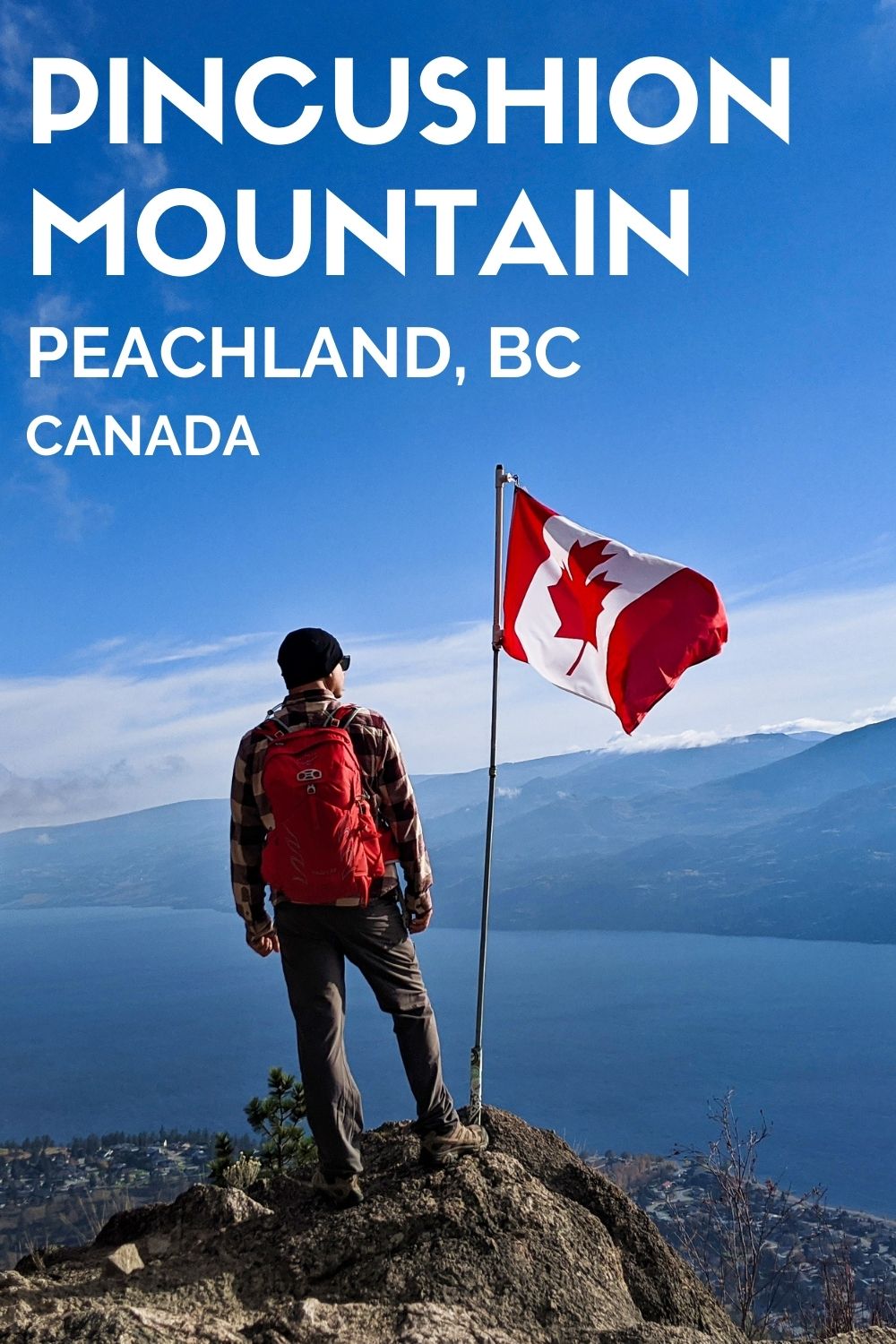
Short yet moderately challenging, the hike to Pincushion Mountain has a spectacular payoff.
Views from the summit showcase beautiful Okanagan Lake, backdropped by Okanagan Mountain Provincial Park and endless other peaks.
These gorgeous panoramas aren’t just limited to the summit, with viewpoints scattered throughout the Pincushion Mountain hike.

Visiting the Okanagan Valley but only have time for one hike? Pincushion Mountain is a great choice if you have the stamina.
Centrally located, the Pincushion Mountain trailhead is only a few minutes drive from Highway 97. This also makes it an ideal place to stretch your legs when travelling through.
This post shares everything you need to know about hiking Pincushion Mountain including:
Pincushion Mountain Trail
Location: Peachland, British Columbia
Distance: 2km one way from trailhead
Elevation change: 245m elevation gain
Hike type: Out and back
Time: Allow 2 hours return with summit stop
Difficulty: Moderate – steady ascent, with steep/rock sections
Dogs: Allowed (please use a leash)
Hazards: Busy trail, steep drop-offs, rocky sections

Hiking necessities
Before heading to Pincushion Mountain:
- Always bring the 10 Essentials
- Know how to stay safe
- Remember to Leave No Trace to help keep nature beautiful
- Understand how to avoid negative bear encounters
- Check out our recommended gear
- Read the safety advice carefully – be sure to hike within your limits
This post contains some affiliate links. If you make a purchase via one of these links, I may receive a small percentage of the sale at no extra cost to you.

About Pincushion Mountain
Pincushion Mountain is a 815m high peak in Peachland, British Columbia. The summit viewpoint area is reached via a 2km one-way trail featuring a moderate ascent (245m elevation gain).
It takes about an hour to hike to the top of Pincushion Mountain and 45-50 minutes to come back down.
If you’re a regular hiker or trail runner, subtract 10-15 minutes. But there’s no need to rush – this is a hike with plenty of reasons to take your time.
Why is it named Pincushion? Good question! It goes back to a 19th century fire that swept through this area and left very few trees standing. As a result, the mountain looked like a pincushion from afar!

Pincushion Mountain: Hike Experience
The Pincushion Mountain hike starts with a set of stairs, which shortly becomes a dirt trail leading uphill. The climb starts right here and now!
Within a few minutes of leaving the parking lot (or about 240m), the trail reaches a wide dirt road.

Turn right and walk along the road for less than a minute, looking left for the brown Pincushion Mountain sign that will lead you back to the main trail. It’s easy to miss so keep your eyes peeled.
From here, the steady climb continues with the help of a couple of switchbacks. The views start to appear at this point – perfect timing as you may well need a break!

Traversing Pincushion Mountain
At the 1km mark, the path reaches the ridge of the mountain and turns south. Though the trail flattens out, a new challenge appears.
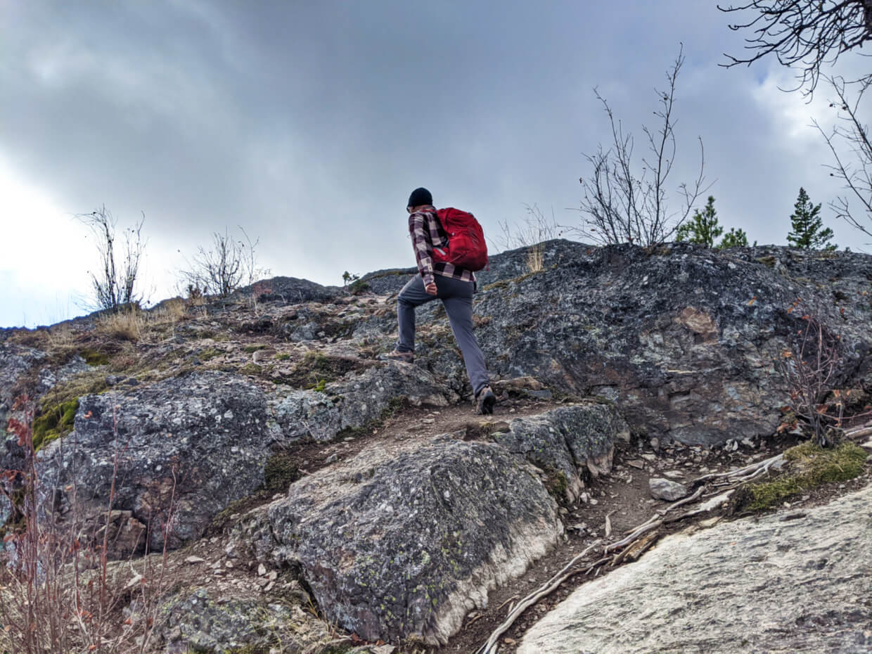
Sections of the path cross small rocky outcrops, where a little careful footwork is required. Take your time and use your hands if you need to.
These more technical sections never last too long (and I say that as someone who doesn’t enjoy them) and are intersected with regular dirt trail.
After one last rocky part (photo below), the views suddenly open up. The summit of Pincushion Mountain is just ahead.
Pincushion Mountain Summit and Viewpoint
The Pincushion Mountain Summit offers incredible views in almost every direction. But don’t stop here – the best is still to come. Just 140m past the actual summit (which isn’t signed) is the viewpoint.
The trail to get there actually descends a little and traverses a few more rocky outcrops. Look for the flag pole, which usually would have a Canadian flag flying proudly.
Next to the flagpole is a picnic table, which offers a comfortable place to sit and snack while taking in the gorgeous panoramas. Of course, there are plenty of other places to rest and relax in this viewpoint area as well.
On a good weather day, it’s easy to spend a long time at this viewpoint. When you’re ready, head back down the trail the way you came.

Hiking guide to Pincushion Mountain
In this section, you’ll find all the nitty-gritty info about hiking Pincushion Mountain. I hope it will help enhance your own hike!

Location
Pincushion Mountain is located in the municipality of Peachland (pop. 5000) in the Okanagan Valley of British Columbia.
The trailhead for the hike is found just off Ponderosa Drive, which leads directly from Highway 97. There is some signage to look out for. The trailhead is also correctly marked on Google Maps.
Ponderosa Drive gains elevation very quickly after leaving the highway and has a number of switchbacks. The turnoff before reaching the turnoff for the Pincushion Mountain trailhead is 2.8km from Highway 97.
Be aware that there is building development happening in the Ponderosa Drive area, with traffic controllers on duty.
Driving distances/time:
Downtown Kelowna: 25.8km/26 mins
97C Highway intersection: 12.4km/12 mins
Downtown Summerland: 26.5km/23 mins
Downtown Penticton: 42.4km/35 mins

Parking
The Pincushion Mountain parking lot has space for around 12-15 vehicles (see below). There isn’t a lot of space and it usually fills up quickly on busy days.
Once the parking lot is full, there is the option to park on the street. Please be super considerate of local residents when doing so, by ensuring that your vehicle does not block any driveways or important street features (intersections, fire hydrants etc.)
If you’re heading to Pincushion Mountain on a weekend, I’d suggest arriving early (before 9am). The photo above was taken on a weekday in late October.
There is usually a single porta potty in the parking lot during the summer months. Bring your own toilet paper.

The best time to hike Pincushion Mountain
Though it can technically be visited all year round, Pincushion Mountain is best hiked from April to November. The most ideal months are April, May, September and October.
In the summer months (June-September), the heat can make hiking a bit unbearable. During this time, I’d recommend starting to hike Pincushion Mountain before 9am or after 6pm.
With the trailhead being located at 570m, snow and ice is likely from December to early March. The snow is usually packed down quickly and the path can become exceptionally slippery (see hazards section for more info).
Peachland occasionally gets snow outside of these months but it doesn’t typically hang around long at this elevation.
Like many hiking trails in the Okanagan, the path can be muddy in early spring. This can also make things a little slippery (and messy).

Navigating the trail
The Pincushion Mountain Trail is signed at the trailhead and sporadically along the route.
There are brown signs with the trail name, #3 and arrows (like the one in the photo below) as well as basic yellow directional signs (as in the photo above).
The trail itself is well defined in most sections, with the exception of the short rock ascents/descents.
There is one potentially confusing section at the 240m mark, when the trail arrives onto a wide dirt road. Turn right (north) along the road and continue walking for another minute and then look left for the trail sign (in the photo below) to continue hiking.
The Pincushion Mountain Trail is clearly marked on the Maps.me app. Download the maps from the Peachland area before heading to the trailhead and you’ll be able to use them offline.

Wildlife
Pincushion Mountain may not be in complete wilderness but it’s still home to many animals such as deer, grouse, marmots, garter snakes, vultures and bald eagles. We spotted one of the latter on our last Pincushion hike (see below photo).
Bears are very occasionally seen in this area so be sure to stay alert, make noise and know what to do if you see one.
JR and I always carry bear spray with us as a ‘just in case’ precaution. We don’t often see bears while hiking but when we have, it’s been surprisingly close to civilisation!
No matter the type of wildlife you see, remember to keep your distance and make sure they have an escape route away from you. Avoid accidently feeding them by packing out everything you bring with you (including ‘natural’ items like apple cores).

Trail hazards and important safety info
The Pincushion Mountain Trail may be short but it has a number of hazards for hikers. Most of them relate to the rocky nature of the hiking trail itself.
If you take on these hazards carefully (and with the right footwear), you’re unlikely to have any issues.
- There are some steep sections, with loose gravel. This can make the hike down more difficult. Hiking poles can be helpful here
- There are several short rock ascents/descents are necessary. You may need to use your hands for stability. One of these areas is pictured below and the other is shown within the ‘hike experience’ section of this post
- The Pincushion Mountain viewpoint is also rocky, with some steep drop-offs. There’s still plenty of space for multiple groups of hikers, but be careful to watch your footing and remain alert of what is going on around you
- In winter, there will likely be some snow and/or ice on the trail. Keep in mind that the trailhead is located at 570m and there is 245m of elevation gained during the hike
- Being a popular trail, fallen snow is usually packed down quickly. In winter, I’d recommend bringing microspikes for grip support
- There is intermittent shade on this hike. The ponderosa pines do provide relief from the sun but there are a number of exposed sections. Avoid hiking in the hottest part of the day in summer (11am-5pm)
- Keep your dogs and children close and under control. As mentioned, there are steep sections and drop-offs which can be very dangerous

Essentials items to bring
- Water – Whatever you do, be sure to bring some water on this hike. This is particularly true during the warmer months (May-Oct). If you are bringing your dog, have plenty extra for them too!
- Proper hiking footwear. For the sake of your feet and balance, I’d definitely recommend hiking shoes or boots to hike Pincushion Mountain
- Hiking poles. It’s helpful to have a hiking pole (or two, whatever your preference) on this trail, especially since there are sections with loose gravel. We love Black Diamond’s Carbon Z series (SO LIGHT)
- Layers of clothing. It is very likely that you will get a little hot while climbing to the top of Pincushion Mountain, so be sure to bring/wear layers of clothing so you can cool down easily
Other Okanagan Valley hiking posts
Hiking Giant’s Head Mountain, Summerland
16 Fast and Fun Hikes in Penticton
Walking the KVR Trail in Penticton
Hiking McIntyre Bluff, Okanagan Falls
Hiking the Peach Cliff Trail in Okanagan Falls
Myra Canyon Trestles, Kelowna: A Complete Guide
8 Fast and Fun Hikes in Vernon


One half of the Canadian/British couple behind Off Track Travel, Gemma is happiest when hiking on the trail or planning the next big travel adventure. JR and Gemma are currently based in the beautiful Okanagan Valley, British Columbia, Canada. Consider buying us a coffee if you have find any of our guides helpful!
I wish every trail description was exactly like this. Great work! Very helpful.
Thank you Liam! Have a great hike.
I just have a question Gemma: I’ve been eyeing-up this hike for months and wondered if those steep rocky areas are perilously close to the edge of a drop-off? Is it inevitable that I’ll end up really close to the edge somewhere along the way? I don’t mind clambering on rocks, but I don’t want to walk on the edge of a cliff! Thanks for your help.
Hi Candice,
There is a pretty steep drop-off, but you can go further ‘inland.’ You’d be on less established trail, however, but away from the edge.