All roads lead to Merritt, a small town set in a calming landscape of rolling grasslands and intricate lakes.
Situated at the crossroads of British Columbia’s principal highways, Merritt acts as a gateway into the vast interior region.
Living in the Okanagan Valley, we pass through Merritt reasonably often – it’s usually a gas stop. But then we had a realisation:
The same highways that make it so easy to drive through Merritt also make it incredibly straightforward to explore Merritt.
And so we did.

This post features twelve Merritt hiking trails, all of which are accessible within only 30 minutes drive of downtown. More than half are actually less than 15 minutes away. We have tried and tested each one.
If you love the outdoors and prefer to spend more time exploring the trails than sitting in your vehicle, Merritt is a great choice for a weekend getaway or extended stay.
In partnership with Tourism Merritt. This post includes some affiliate links. If you make a purchase via one of these links, we may receive a small percentage of the sale at no extra cost to you.
Merritt hiking trails: what to expect
- An introduction to Merritt
- When to go
- Map and navigation details
- Essential items and info
- Merritt hiking trails
- ‘Walk of Stars’ and Downtown Murals
- Coldwater River Trail
- Norgaard Flagpole
- Tom Lacey Memorial Trail
- Tower Access Trail, Coutlee Plateau
- Godey Creek Trail, Iron Mountain
- Too Much Info Trail, Iron Mountain
- Sugarloaf Mountain
- Laurie Guichon Memorial Grasslands Interpretive Site
- Kane Valley Trails
- Harmon Lake Interpretive Forest
- Kentucky Lake Loop Trail
An introduction to Merritt
Merritt (pop. 7000) is the largest community in British Columbia’s beautiful Nicola Valley. It is a three hour drive (270km) northeast of Vancouver.
Long before the highways were built, people were drawn to this area. The rivers, lakes and open grasslands provided easy transportation routes and plentiful food for the Nlaka’pamux, Syilx and Stuwix people.
European ranchers arrived in the late 19th century and settled at the confluence of the Coldwater and Nicola rivers, naming their new community ‘Forksdale.’ The townsite was renamed in 1906.

Merritt still has a proud ranching heritage today, with Douglas Lake Ranch (established 1886) still Canada’s largest working cattle ranch – a gigantic 515,000 acres in size! Other primary industries include farming and forestry.
In recent years, Merritt has also developed a reputation for hosting music festivals (particularly those featuring country musicians) and other major events.
We would like to acknowledge that the following hiking trails are located on the unceded territory of the Nlaka’pamux Nation and Syilx Nation. Learn more about the indigenous people of the Nicola Valley here

When to go hiking in Merritt
Merritt is situated at an elevation of 595m. The climate is pretty favourable (by BC standards!) with reliably hot, sunny summers and cold winters.
Total annual rainfall and snowfall are both low (189.3mm and 99.6m respectively). We were assured by locals that the snow never sticks around at the town level for too long!
This warm, dry climate makes Merritt an ideal destination for outdoor adventure, particularly during the shoulder season months when so many other BC locations remain snowy or rainy.
The following Merritt hiking trails were all firmly snow free (and had been for some time) in late May. I would suggest April, May, September and October to be the best months for comfortable hiking temperatures.
In the summer and winter, Merritt is an excellent base for alpine exploration in the Coquihalla Summit area (backcountry skiing, hiking etc.)

Merritt hiking trails map
Tourism Merritt has produced an excellent hiking trail map featuring the majority of the paths recommended here.
The two sided map includes close-up details of Skakum Mountain, Coutlee Plateau, Sugarloaf Mountain, Iron Mountain and the Kane Valley. Download the PDF or pick up a paper copy at the historic Baillie House in downtown Merritt.
To complement this post, I have put together an interactive Google Map. You’ll find the trailheads of all of these Merritt hiking trails marked, along with food and accommodation recommendations. Click the image below to view the map in a new browser window.
I have noted how much signage there is on each Merritt hiking trail in the ‘essential details’ information section.
For navigation, we personally use and highly rate the Maps.me app. All but one of these trails (Harmon Lake Interpretive Forest) are accurately marked, with distance and elevation as well. The majority are also found on AllTrails and TrailForks.

Hiking in Merritt: Essential items and info
Whether you’re an experienced hiker or a first timer, you may find the following tips helpful when planning a trip on Merritt’s hiking trails:
- Always make noise to alert wildlife of your presence. If you see wildlife, be sure to keep your distance and leave them an escape route
- For all but the most urban trails (such as the Walk of Stars, Coldwater River Trail) I would recommend bringing bear spray. It is effective against all large mammals
- Grazing cattle may be present on some of these Merritt hiking trails. Stay away from groups of cows, especially when calves are present. Dogs should be on a leash. Close gates behind you
- Merritt has a dry climate. Bring plenty of water with you (and extra for your dog if have one!) Some of these hikes have water sources – filter or purify water before drinking
- Temperatures in Merritt can be very high in June, July and August. Be sure to have a sun hat and sunscreen. Avoid hiking during the hottest part of the day
- Some of these Merritt hikes are in isolated areas with intermittent phone signal. Always let someone know where you’re going and when you plan to get back
- Be sure to Leave No Trace while hiking. This ensures that natural places such as these remain beautiful for years to come!
- Hiking poles may be useful on some of these hikes. None are remarkably difficult but poles can help reduce stress on the knees. We use and love Black Diamond’s incredibly lightweight Carbon Z poles

Merritt Hiking Trails
And here we go, 12 of the best short hiking and walking trails in Merritt, British Columbia.
Walk of Stars and Downtown Murals
It may not be a traditional hike, but a visit to Merritt wouldn’t be complete without a walk in the downtown area. It’s a little more special than your average small town in BC, especially if you like country music!
Merritt’s ‘Walk of Stars’ celebrates country musicians who have visited or played in the Nicola Valley. More than 70 hand prints (and one footprint!) have been embossed into gold stars and placed outside downtown stores.
Search for your favourite musician or see them all with this handy map (alternative guide here). Above and alongside the stars, you’ll also notice large scale murals by Michelle Loughery featuring other country music legends.
To top it all off, Merritt is also home to the Canadian Country Music Hall of Fame – it’s located right on the Walk of Stars route on Quilchena Ave.
While walking the Walk of Stars, keep an eye out for two of Merritt’s oldest buildings – Baillie House (built in 1908, now the Visitor Information Center) and the Coldwater Hotel (1910).

Essential details
Trail length and elevation: 1-2km, flat terrain
Difficulty: Urban walking
Average time needed: 1 hour
Signage: Star plaques outside downtown stores
Facilities: Closest public toilets are at the Visitor Information Center at Baillie House

Coldwater River Trail
Feel the need to stretch your legs after lunch in downtown Merritt? The Coldwater River Trail is a great option for a relaxing nature stroll.
Starting from the parking lot just south of Merritt Central Elementary, the flat, paved path stays close to the rushing Coldwater River. Trees line the path, providing some shade on sunny days.
At Vought Park, the path loses the river for a short time. Turn right on Main Street and then reunite with the path on Canmore Ave. Continue for another 200m to reach a bridge where the Coldwater River flows into the Nicola River.
Here, you can either turn around and return the same way (total distance noted below) or walk along Quichena Ave towards downtown, to complete a large loop.
If you have children with you, be sure to keep them close as there are some steep drop-offs at several points along this trail. Dogs should be on a leash.
If you’re looking for more options for urban strolls in Merritt, check out the Walk of Stars (above) or Rotary Park. The latter has a flat, paved trail to Central Park.

Essential details
Trail length and elevation: 3.3km return, flat
Difficulty: Wide, paved riverside path, some urban sections
Average time needed: 1-2 hours
Signage: Trailhead sign in parking lot
Facilities: Parking lot, public washrooms in Vought Park, litter bins, benches
How to get there: The Clearwater River Trail parking lot is adjacent to Central Elementary School on Vought Street. If you drive over the Coldwater River, you’ve gone too far!

Norgaard Flagpole Trail
The best views of Merritt are also the most accessible! The Norgaard Flagpole offers gorgeous panoramas of downtown Merritt, Iron Mountain, Coutlee Plateau and beyond.
If you’ve just arrived in Merritt for the first time, I’d recommend a trip up to the Norgaard Flagpole to get your bearings.
While it’s possible to drive two thirds of the way up, hiking from the bottom provides a challenging workout and also avoids the dirt and rocks of the private access road. There is, however, no shade along the route, so keep that in mind.
The total distance to the Flagpole is 1.9km one way. If you decide to drive part of the route, the final approach to the Flagpole is 1km from the lower parking lot and just 300m from the upper parking lot.

Essential details
Trail length and elevation: 1.7km one-way, 160m elevation gain
Difficulty: Steady, short uphill on rocky dirt road
Average time needed: 1-1.5 hours
Signage: At Juniper Road junction only
Facilities: None
How to get there: The Norgaard Flagpole trailhead is just a three minute drive from downtown Merritt. Look for the turnoff between the gravel pit and the cemetery on Juniper Road. Park on the right hand side of the road in front of the viewpoint sign. As mentioned, it is possible to keep driving to two parking lots.

Tom Lacey Memorial Trail
If you’re looking for a longer hike after reaching the Norgaard Flagpole (either by foot or vehicle), look no further than the Tom Lacey Memorial Trail.
This meandering path traverses the side of Swakum Mountain, the closest peak to downtown Merritt.
Along the way, you’ll get to take in beautiful views of Merritt from a variety of different perspectives. In late spring, the dirt trail is lined by pretty wildflowers.
If you’re short on time, I’d suggest starting at the Norgaard Flagpole and hiking 2km before turning around (1-1.5 hours). There’s a bench here with a great vista of Merritt – the perfect stop for a snack or picnic!
Please note that this Merritt hiking trail is a popular for off leash dog walking. Facing southeast, it can get quite hot on sunny days and there is intermittent shade.

Essential details
Trail length and elevation: 3.8km one-way
Difficulty: Narrow dirt trail with short climbs and descents
Average time needed: 2-3 hours for full length
Signage: Some directional signs. I’d recommend using Maps.me to stay on track as there are a lot of interconnecting trails in this area
Facilities: Benches
How to get there: There are two main trailheads – one at the Norgaard Flagpole and the other on Grimmet Street. For the Norgaard Flagpole trailhead, follow the directions above

Tower Access Trail, Coutlee Plateau
Located just to the south of downtown Merritt, the Coutlee Plateau is a popular mountain biking area. The open ranch-like setting hosts a number of looping single-track trails, with varying difficulty levels.
For a quick workout with a view, consider hiking the Tower Access Road. The dirt track leads uphill from the parking lot to a pretty lake, surrounded by blossoming meadows.
The trail then turns away from the lake, climbing up towards a pair of radio towers perched on a rocky ridge. Sweeping views of Merritt can be found just behind the towers.
If you have a high clearance vehicle, you could drive part way up the Tower Access Road. The road becomes a lot more bumpy and rocky after passing the lake (800m from the towers).

Essential details
Trail length and elevation: 2.2km one way, 130m elevation gain
Difficulty: Dirt road with steady incline
Average time needed: 1.5-2 hours
Signage: Trail map in parking lot, no other signage
Facilities: Dedicated parking lot
How to get there: Navigate to Midday Valley Road, which becomes dirt short after the Houston Street junction. At the 2km mark, look left to spot hoodoos across the Coldwater River! The Coutlee Plateau parking lot is located approximately 4.5km up Midday Valley Road, shortly after the second cattle guard. The dirt Tower Access Road is opposite the parking lot

Godey Creek Trail, Iron Mountain
Though short and sweet, Godey Creek is definitely one of the best Merritt hiking trails. Shady and quiet, this forested path is also popular for birdwatching.
Starting behind the old Visitor Center on Highway 97C, the path winds up through spruce trees to reach Merritt’s best sunset spot.
Bring a snack or some takeout (remember to Leave No Trace!) and enjoy the views from the well placed bench. There’s an outhouse nearby too.
The Godey Creek Trail can be hiked as a short or long loop or part of a longer Iron Mountain adventure. For example, the Too Much Info Trail (more details below) intersects with Godey Creek.
Please note that the Godey Creek Trail attracts mountain bike users as well as hikers.

Essential details
Trail length and elevation: 1.9km loop (large version), 80m elevation gain
Difficulty: Dirt singletrack, occasionally narrow, with short ascents/descents, some switchbacks
Average time needed: 1 hour or less
Signage: Trail map at trailhead, some directional signs on trees
Facilities: Road parking, outhouse at mid-way point (details above), benches
How to get there: The old Visitor Center is located right at the intersection of Highway 97C/5A and Highway 5. When driving from downtown Merritt, head towards Kelowna on the 97C and turn right after passing over Highway 5. Then turn left onto Hamilton Road, where there is plenty of parking on the road. Walk behind the old Visitor Center to locate the trailhead

Too Much Info, Iron Mountain
The Too Much Info Trail, located at the base of Iron Mountain, is definitely one of those hikes that is more about the journey than the destination.
The single-track path zig zags through the lush forest, revealing peek-through views of Merritt and Swakum Mountain as it gently climbs in elevation.
But those views aren’t the highlight. It’s the nature that surrounds the trail that is the real winner here, from the delicate wildflowers on the forest floor to the gnarled, mossy trees reaching to the sky.
The shady, forested path of Too Much Info has a very different feel than any other of the other Merritt hiking trails mentioned here.
Part of an extensive multi-use trail system, it is possible to hike Too Much Info as an out and back trail and also part of a loop. Since there is no panoramic view at the top, you could also turn around at your preference.
Whatever you do, just be sure to pay attention to other trail users, especially at junctions.

Essential details
Trail length and elevation: 3.7km one-way, 250m elevation gain
Difficulty: Singletrack dirt path through forest with gradual ascent
Average time needed: 2-3 hours
Signage: Trail map at trailhead, many directional signs on trees
Facilities: Road parking, nearest outhouse is on Godey Trail (see above)
How to get there: The Too Much Info trailhead is located adjacent to the old Visitor Center at the corner of Highway 97C/5A and Highway 5. When driving from downtown Merritt, head towards Kelowna on the 97C and turn right after passing over Highway 5. Then turn left onto Hamilton Road, where there is plenty of parking on the road. Look for the trailhead signage through the trees on the right

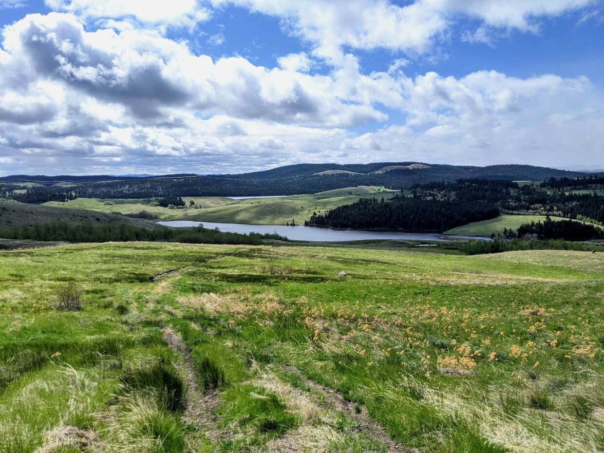
Sugarloaf Mountain, Lundbom Grasslands
The Sugarloaf Mountain area, just a short drive east of Merritt, is home to one of Canada’s rarest and most at risk ecosystems – native grassland.
This landscape of golden grasses, rolling hills and intricate lakes provides gorgeous destination for hiking. There’s an impressive network of multi-use trails here with a number of different trailheads.
The rocky summit of Sugarloaf Mountain (1366m) offers spectacular panoramas of the golden grasslands below as well as Merritt, Swakum Mountain, the Coutlee Plateau and even the snow capped coastal mountains.
It can be accessed as a detour from the Wounded Knee Trail, which can be hiked out-and-back or as part of a larger loop.
Due to the sensitive ecosystem, it’s important to stay on the established trails. Please be aware that the the Lundbom Grasslands are used for grazing cattle as well as recreation. There is also very little shade.

Essential details
Trail length and elevation: 11km loop, 420m elevation gain
Difficulty: Second half features uphill ascent with steep and rocky sections, particularly just below the summit
Average time needed: 3-4 hours
Signage: None for this specific trail, general trail map in Recreation Area
Facilities: Road parking, outhouses in nearby campgrounds
How to get there: From Merritt, drive east (towards Kelowna) on Highway 97C/5A. Turn left on Lundbom Lake Road. Continue along this dirt road until half way along Lundbom Lake. We parked on the side of the road here and then walked up the hill to reach the trails. Sites and Trails BC advises to park at the top of the hill

Laurie Guichon Memorial Grasslands Interpretive Site
A quick stop at the Laurie Guichon Memorial Grasslands Interpretive Site is definitely worthwhile, especially if you’ve never visited the Nicola Valley before.
An information kiosk lies just up the hill from the parking lot and features displays on the Southern Interior grasslands, ranching culture and the three founding First Nations of Merritt.
A short walk in the other direction leads through a riparian zone to a pond viewing platform, where you can try and spot nesting birds.
Laurie Guichon was a fourth generation rancher and a noted grasslands conservationist.

Essential details
Trail length and elevation: 720m return, flat (to the viewing platform)
Difficulty: Easy trail, partially on road
Average time needed: 30 minutes
Signage: Map in parking lot
Facilities: Parking lot, outhouses, interpretative signs
How to get there: From Merritt, drive east (towards Kelowna) on Highway 97C/5A. Turn left on Lundbom Lake Road, parking lot is 300m on right hand side. 15 minutes drive from downtown Merritt

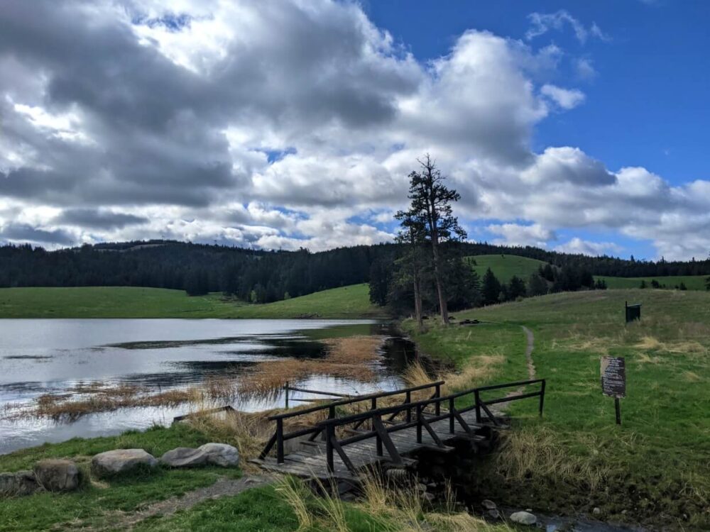
Kane Valley Trails
The Kane Valley is best known as Merritt’s premier cross country ski destination. But this large network of forested trails, meticulously maintained by the Nicola Nordic Ski Club, can be enjoyed in summer too.
With dozens of looping and interconnecting trails, it’s possible to ‘choose your own adventure’ through the beautiful pine and aspen forest, across natural grassy meadows and past a scattering of small, intricate lakes.
These Merritt hiking trails vary in elevation and difficulty. Steep hills are clearly marked on Nicola Nordic’s excellent map. Signage on the trail is impeccable too, with trail maps displayed at junctions.
To get a taste of the area, we started at Parking Lot 5 and circled back via the Kane, Ravine, Sundown and Aspen trails.
The Nicola Nordic Ski Club asks day users to contribute $10/per person to help with trail maintenance costs.

Essential details
Trail length and elevation: Varies
Difficulty: Wide, well maintained trails, ranging in difficulty
Average time needed: 1-4 hours
Signage: Trail maps in parking lots and at every trail junction
Facilities: Multiple parking lots, day use shelters, benches, outhouses close to all parking lots
How to get there: From Merritt, drive east on Highway 97C/5A. Turn right on the (unpaved) Kane Valley Road, approximately 18km from downtown Merritt. The Kane Valley trail system starts 1.5km from the highway junction

Harmon Lake Interpretive Forest
Learn more about the diverse ecosystems of the Kane Valley at the Harmon Lake Interpretive Forest. This family friendly trail is punctuated with informative signage explaining forest lifecycles, management and ecology.
As well as being educational, the short walk offers some lovely views of the surrounding lakes and the chance to see impressively large trees.
At the very end of the trail there is a boardwalk leading out onto Secret Lake. This marshy lake is an important habitat for many animals, both large and small. From here, the path loops back to the parking lot via a creek.
Partially shaded and located at 1100m, this Merritt hiking trail is ideal for warm, sunny days when it may feel too hot to hike elsewhere.

Essential details
Trail length and elevation: 2.7km loop, less than 50m elevation gain/loss
Difficulty: Mostly flat trail through forest and clearings, with occasional short, steady climbs
Signage: Trail map in parking lot, clear signage along route
Average time needed: 1-2 hours
Facilities: Parking lot, interpretative signs, benches, shelter, outhouses in nearby campground
How to get there: From Merritt, drive east on Highway 97C/5A. Turn right on the (unpaved) Kane Valley Road, approximately 18km from downtown Merritt. Continue for 9km. Enter Harmon Lake East Recreation Site and turn left. Follow the northern shore of the lake and stay right at the turnaround.

Kentucky Lake Loop, Kentucky-Alleyne Provincial Park
There’s no need to go all the way to the Rockies to see some beautiful turquoise lakes – you can find some just outside Merritt in Kentucky-Alleyne Provincial Park!
This provincial park protects a chain of vibrant lakes, a product of thousand year old glacial deposits. One of the largest, Kentucky Lake, features a beautiful circular loop trail.
Hiking around the entirety of this lake is an interesting experience, especially since the tropical colours vary in shade and vibrancy. Even on a cloudy day, there’s still a lot to see.
As the trail continues to the far end of the lake, the lake deepens to an stunning emerald hue. Follow the path along the other side of the lake to return to the parking lot.
Suitable for all the family, this Merritt hiking trail is definitely one of a kind!
Please be aware that there may be downed trees on the path in late spring.

Essential details
Trail length and elevation: 4.5km, minimal elevation change
Difficulty: Lakeside circuit with gentle ups and downs
Signage: Directional signs at trailhead
Average time needed: 1.5-2.5 hours
Facilities: Dedicated day use parking area in campground, outhouses
How to get there: First, take Highway 97C east from Merritt. After 20 minutes (27km), switch onto the 5A (Princeton). Continue for 7km before making the signposted left hand turn to Kentucky-Alleyne Provincial Park. After arriving within park boundaries, look for Kentucky Lake Campground on the right. There is a day use parking lot by the lakeshore, next to the hike trailhead

Best Merritt Hiking Trails
Not sure how to decide which of these Merritt hiking trails to try first?
- The Tom Lacey Memorial Trail has a great reward to effort ratio, with scenic views throughout
- Godey Creek is the ideal place for a picnic with a view
- Hiking with a young family? Head to the Kentucky Lake Loop, the Kane Valley network or the Harmon Lake Interpretative Forest
- Sugarloaf Mountain is perfect for adventurous hikers looking for long (10km+) day hikes
- Too Much Info provides excellent shade on hot, sunny days

Where to stay in Merritt
Situated at such an important crossroads, finding somewhere comfortable to stay in Merritt is easy. There are a number of large chain hotels as well as budget friendly motels and inns.
Best Western Plus – Merritt’s newest and largest hotel offers spacious rooms as well as a swimming pool, hot tub and communal patio (BBQs available in summer). Hot breakfast is included with every stay. Access to Merritt’s hiking trails is both quick and easy, with the hotel being located right off Highway 5.
Knight’s Inn – This highly rated motel provides excellent value for money, with well equipped kitchenettes in every room. Though not located right in the downtown core, the Knight’s Inn is still within walking distance.

Campers are also spoiled for choice in Merritt!
- Kentucky-Alleyne Provincial Park has 58 vehicle accessible campsites, many of which are either lakeside or have a lake view. Just over half of the campsites are first come, first serve
- There are three rustic Recreation Site campgrounds in the Kane Valley, one of which borders the Harmon Lake Interpretive Forest (trail details above)

- The Lundbom Grasslands also hosts a number of Recreation Site campgrounds, with Lundbom Lake being the largest with 102 well defined campsites
- The Recreation Site on nearby Marquart Lake is separated in two, with the western side featuring three scenic walk-in (tent only) campsites
- Bluey Lake is located just south of Kentucky-Alleyne Provincial Park and also features the same gorgeous aquamarine colours. The access road to the small Recreation Site is quite narrow and rough
These Recreation Sites operate on a first come, first serve system. The overnight camping fee is $15 per group (with the exception of Blue Lake, which is free), collected by a park host.
For serviced sites closer to town, check out Moon Shadows RV Park & Campground (right next to the Coldwater River) or Claybanks RV Park (across from the Coldwater River Trail).
Where to eat in Merritt
Kekuli Café – A must stop while in Merritt! Kekuli Cafe is a locally owned, indigenous coffee shop specialising in handmade sweet and savoury bannock (fry bread). Menu highlights include tasty bannock-wiches (get it?) and wholesome tipi tacos, with venison and salmon versions. Be sure to take a sweet treat or two (I loved the Saskatoon berry flavour) with you for hiking snacks!
Grand Pub & Grill – The Grand has been a mainstay of downtown Merritt since 1963. The extensive menu includes many Canadian pub favourites such as wings, burgers and ribs. The charcuterie boards are perfect for sharing and even come with beer included.
Yaki Joe’s Pizza – Reward yourself after a long day of hiking with a freshly made pizza from Yaki Joe’s. There are over 20 different topping options or go freestyle. If you’re looking for more than just pizza, Yaki Joe’s also serves wraps, wings, salads and pasta.
Empty Keg Brew House – Conveniently located next door to Yaki Joe’s, this laid back (no TVs!) family friendly brewery is relatively new to the Merritt food and drink scene. There is a bar menu but it is also permitted to bring in food from other local establishments to help support the community as a whole
Exhausted after a day exploring Merritt’s hiking trails? You’ll be happy to know that most restaurants will deliver right to your hotel room.


PIN or save this post for later with one of the above images
Other hiking posts you may find helpful
Heather Trail, Manning Provincial Park
Frosty Mountain, Manning Provincial Park
Twin Lakes, Monashee Mountains
16 Fast and Fun Hikes in Penticton
9 Fast and Fun Hikes in Vernon
13 of the Best Shoulder Season Backpacking Trips in BC
25 of the Best Overnight Backpacking Trips in BC

One half of the Canadian/British couple behind Off Track Travel, Gemma is happiest when hiking on the trail or planning the next big travel adventure. JR and Gemma are currently based in the beautiful Okanagan Valley, British Columbia, Canada. Consider buying us a coffee if you have find any of our guides helpful!
Excellent resource..thx
Thanks for letting me know you found this post helpful!
Great that you mention the Stuwix (Strangers in Salish) people whose traditional territory around Nicola Lake was mapped by famed BC ethno-anthropologist James Teit in his seminal book The Thompson Indians. As their genocide by neighbouring Secwepemc (Kamloops) about 50 years before the first whites showed up in the area happened within the living memory of elders it was also recorded by Teit and also Franz Boas who made up a brief vocabulary of their Athabaskan language that is otherwise extinct including the translation of the place name Quilchena which was one of their villages. It would be nice if you mentioned them in in the territorial acknowledgement too as a reminder that no-one’s hands are clean and that all BC natives, with or without a status number, belong in our home and native land.
@Jane, yep good reminder! I been searching for info on our gggrandmother Ratchinak but impossible to make any progress as we dont know if she was from Nicola or High Bar area. She had a son Serapio Leon with our gggrandfather Blas Leon at Douglas Lake and Blas had settled near Hamilton Hill but was killed by a falling tree Dec 1877. Serapio was raised on the Spanish Ranch, Clinton by the Bernal’s but nothing more on Ratchinak. Shall remain a mystery i suppose. Blas had come north from California gold rush with his pal Jesus Garcia who ended up purchasing Blas pack train after he was killed.