Situated close to the top of the Okanagan Valley in British Columbia, Vernon is best known for its three spectacular lakes, dry, rugged landscape and consistently warm summer weather.
Hiking is undoubtedly one of the best ways to take in the true beauty of this gorgeous region. And clearly, the locals know it too, with Vernon recently becoming the Trails Capital of BC.
Across the city, the hiking trails are well established and carefully signed, with designated parking and a range of facilities. New trails are funded and developed often. We love to see it!

If you’re looking for some of the best short Vernon hiking trails, this is the list for you.
All of these Vernon hikes are easy in difficulty and short in distance (less than 8km). This makes them a perfect morning or afternoon activity while visiting Vernon.
Alternatively, these hiking trails offer a great opportunity to see more of Vernon while on a day trip from elsewhere in the Okanagan Valley.
And these hiking trails are just a hint of what Vernon has to offer! There are so many awesome things to do in Vernon and even more activities in fall and winter.
I’ve also put together this three day itinerary, to give you a taste of what a Vernon trip can look like.
But back to this Vernon trail guide! JR and I hiked personally hiked more than a dozen trails in Vernon and I’m excited to tell you about them. We live in Penticton, about two hours drive away, so are fairly regular visitors – Vernon is truly one of our favourite local hiking destinations.
This post is in partnership with Tourism Vernon. There are affiliate links. If you make a qualifying purchase through one of these links, we may receive a small commission at no extra cost to you.

Hiking necessities
- Always bring the 10 Essentials
- Know how to stay safe in the backcountry
- Remember to Leave No Trace to help keep the wilderness wild
- Understand how to avoid negative bear encounters
- Recommended gear is listed on our Resources page
- Need a packing list? Sign up to our newsletter for a free one!

Vernon hiking trails
This post highlights our favourite Vernon hiking trails. I’ve put them in preference order to help guide you better. Middleton Mountain is my favourite of all and features at the very top of the list
Use the map below to locate the trailheads of these Vernon hikes. The closest hike to downtown Vernon is only 2km away and the furthest 24km.
As mentioned, all of these Vernon hiking trails have signage at the trailheads so finding where to start is generally pretty easy.

Usually, we use Organic Maps for trail navigation but only some of the following Vernon hiking trails are featured on the app. The trails are generally well established and signed, however.
Tourism Vernon has created their own online trails map, which features the entire local trail network. It’s really impressive and shows a dedication that we haven’t seen in many other destinations.
Please note that mountain bikes also use many of Vernon’s local trails.
The best time to hike in Vernon? Personally I find spring and autumn to be ideal, due to the cooler temperatures. My all time favourite time of year to go is late Aprl, when the bright yellow Arrowleaf balsamroot bloom next to the trails.
These hiking trails are located on the traditional territory of the Syilx/Okanagan People. Be sure to Leave No Trace and respect this unceded territory.

Middleton Mountain
Length of hike: 2km – 3.5km loops
Trail condition: Mostly flat after initial elevation gain (100m), some rocky sections, dusty
Trailhead location: Mt Ida Drive or Mt Tanner Place, Coldstream
Facilities: Maps, navigational signs, benches, interpretative boards
If you have time for just one Vernon hike, I’d highly recommend Middleton Mountain.
The open grassland summit of Middleton Mountain offers spectacular sweeping views of Kalamalka Lake, Swan Lake, downtown Vernon and beyond. It’s an ideal way to orient yourself when visiting Vernon for the first time.
There are two access points to Middleton Mountain, both of which ascend around 100m before reaching four different hiking loops at the top. We’d heard that the steps at Mt Ida Drive were shut so hiked the switchbacks from Mt Tanner Place instead.
No matter the route, there is absolutely zero shade once you start hiking so be sure to start early in the day and wear plenty of sunscreen!
We hiked the perimeter loop (3km), which features magnificent 360 views all the way around as well as plenty of Prickly Pear cacti.

Coldstream Ranchlands Trail
Length of hike: 6.3km loop (plus 900m access road)
Trail condition: Lots of switchbacks – gentle on the eastern side, steep on the western side
Trailhead location: Ravine Drive
Facilities: Navigational signs, bins
I’m always a big fan of a loop trail! The Coldstream Ranchlands Trail is a recent addition (2024) to Vernon’s hiking scene and I’m all for it. I’d rate it as one of the best in the area.
This 6.3km loop follows the edge of a 126 hectare natural space overlooking both Kalamalka and Okanagan lakes. It also offers views of the green hills and mountains of the White Valley, which stretches east from Vernon and Coldstream.
To access the trail, you must park in the dedicated lot on Ravine Drive and then hike 900m up the access road. Even here, there are great views to be seen!
The western side of the loop features a series of gentle switchbacks, while the eastern ascent is much steeper. The total elevation gain is about 350m, the majority on the loop itself.
Preferring steeper ascents, we hiked the loop counter-clockwise. I’m glad we did as there are some sections with loose rock on the eastern side. If you decide to go down the steeper route and are concerned about that, I’d suggest bringing some hiking poles.

Grey Canal – Turtle Mountain section
Length of hike: 8.5km out and back
Trail condition: Mostly wide path, with one narrow, steep section and one set of stairs (details below)
Trailhead location: End of Blue Jay Road
Facilities: Navigational signs, benches, bins
Curving around an ancient lava flow wall, the Turtle Mountain section of the historic Grey Canal Trail provides stunning vistas of downtown Vernon, Swan Lake and also Okanagan Lake.
Starting from the dedicated parking lot at the end of Blue Jay Road, the trail is wide and meandering, with gentle elevation gain. There are excellent views almost immediately.
Around the 3.3km mark, the path narrows and slopes downhill. Watch your step for loose rocks and old piping equipment here.
Not long after, a short but steep hill leads into the Turtle Mountain development. Cross the road and climb the stairs to reach Rocky Ridge Park, where 360 degree panoramas await! Return via the same route.
It is possible to hike this trail in the other direction, starting from one of the two small parking lots on Turtle Mountain Boulevard. This is also the ideal location to park if you don’t have the time or energy for a 8km hike. From here, it’s just 200m to the Rocky Ridge Park stairs.

Lookout/Parabola Loop, Kal Park
Length of hike: 6.1km loop
Trail condition: Single track dirt path, some short rocky sections, steady uphill climb (260m total elevation gain)
Trailhead location: Red Gate parking lot, Kalamalka Lake Provincial Park Facilities: Outhouses, maps, navigational signs, benches, bins
Kalamalka Lake Provincial Park has an impressive network of trails with many interconnecting routes, allowing plenty of freedom to ‘choose your own adventure’!
The Lookout/Parabola Loop is our favourite trail so far. This two trail combine completes a complete circuit around Kal Park’s mountain, offering almost 360 degree views (though not at once!) of Coldstream, Kalamalka Lake, Vernon, Oyama and even the Monashees.
We followed the trail counter clockwise but when I do it again, I will hike in the other direction. The views on the southern side of the loop are the best and I think they would be better appreciated while going downhill!
For a longer hike, detour from this trail to Upper Turtles Head Point Lookout or Cosens Bay (see below). We did the latter, with the total hiking distance being 11.2km.
Looking for a longer hike within a day’s drive of Vernon? Check out the Pinnacle Lake Trail or Twin Lakes Trail near Cherryville

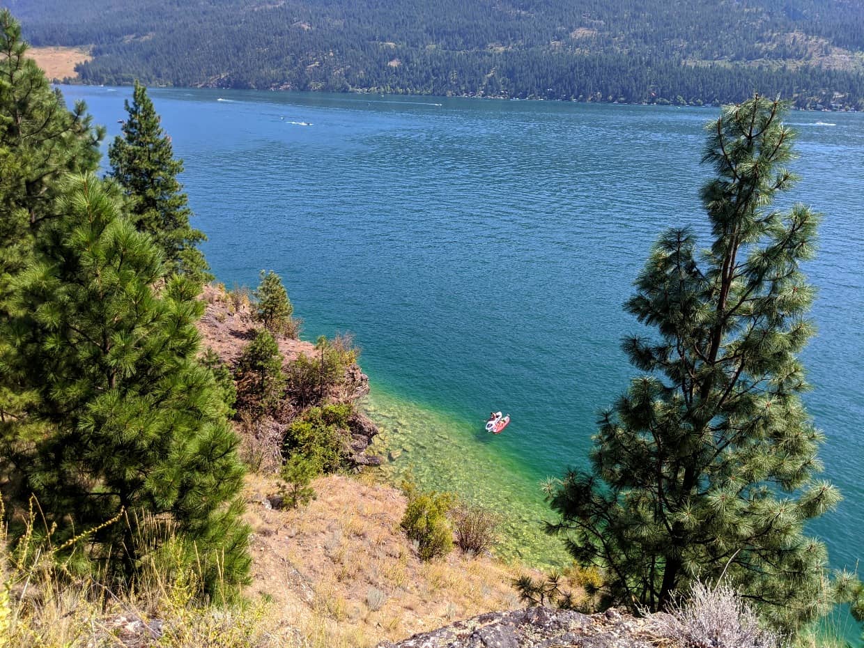
Cosens Bay Trail via Corral Trail, Kal Park
Length of hike: 4.3km out and back
Trail condition: Gravel trail featuring wider and narrower sections, with steady switchback descent to beach (144m elevation gain on return)
Trailhead location: Red Gate parking lot, Kalamalka Lake Provincial Park Facilities: Outhouses, maps, navigational signs, benches, bins
Often cited as the best beach on Kalamalka Lake, Cosens Bay is a gorgeous, secluded stretch of sand only accessible on foot, bike, boat or horse. This hike starts at the Red Gate and then descends to Cosens Bay, via a stunning lake lookout.
Getting back up the hill to the parking lot can feel like a bit of a haul but there are views almost all the way!
The trees lining Cosens Bay turn yellow in fall (with the peak mid to late October) providing a beautiful contrast with the turquoise colours of Kalamalka Lake.
The beach is also accessible from the Cosens Bay parking lot (6.5km return). We started from the Red Gate as we combined this hike with the Lookout/Parabola Loop, as above.

Grey Canal – Cypress Drive Trailhead
Length of hike: 2km out and back
Trail condition: Mostly wide path, mostly uphill with a couple of steep section and some stairs
Trailhead location: End of Cypress Drive (northwestern end), Coldstream
Facilities: Navigational signs, benches, bins
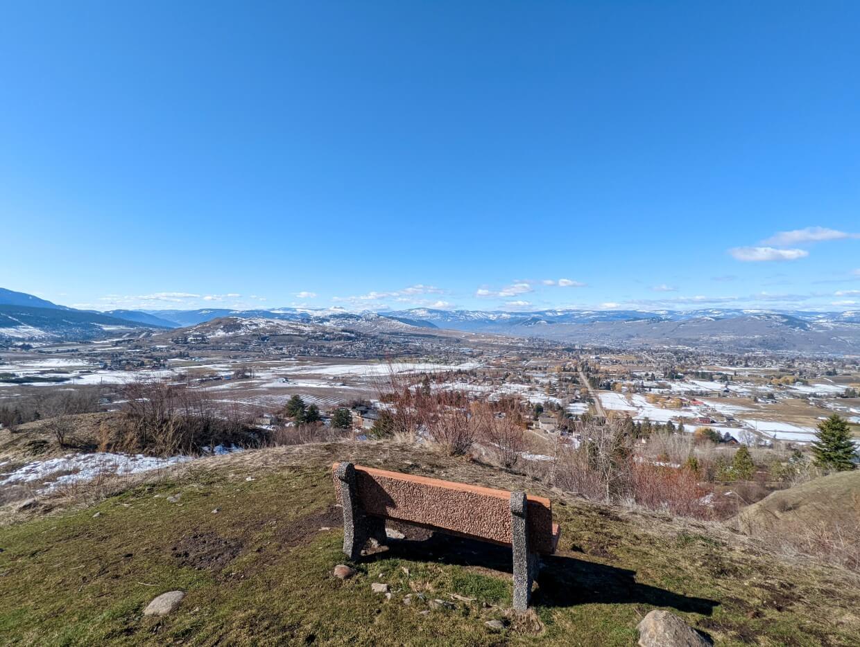
We just can’t get enough of the Grey Canal Trail! This short stretch, from the Cypress Drive Trailhead, offers excellent panoramic views of Coldstream, Vernon and all three lakes. Terrace Mountain provides an imposing backdrop.
Park at the very end of Cypress Drive in Coldstream, where the road ends. The path is flat at first and then begins to climb, curving around the hillside. There are not many trees in this area so it’s easy to see the route ahead.
The first scenic viewpoint is located 500m after the parking area and is marked with a bench (see photo below). The path continues to ascend after the bench, with the help of some stone staircases. Another vista awaits at the 1km point, but the views are great all the way along!
Upper Turtles Head Point Lookout, Kal Park
Length of hike: 2.5km loop
Trail condition: Some short ascents on dirt paths, rocky sections
Trailhead location: Twin Bays parking lot, Kalamalka Lake Provincial Park
Facilities: Outhouses, maps, navigational signs, benches, bins
Turtles Head Point juts into Kalamalka Lake and is an incredibly scenic spot to take in panoramic views and watch boaters on the water. On sunny days it’s even possible to spot Kalamalka’s distinctive turquoise colours from here.
The hike to Turtles Head Point (also known as Rattlesnake Point) is a combination of trails in Kalamalka Lake Provincial Park. From the Twin Bays parking lot, follow directions for the Crest Trail. The trail starts to ascend after the dog beach trail turnoff, with some switchbacks.
The lookout itself is very exposed but can be wonderfully breezy, even on the hottest days. To complete the loop, descend the short staircase and follow the Juniper Trail. There’s a side trail to the lower Turtle Head lookout.
Be sure to make the detour to Juniper and Jade beaches – they are ideal spot for a post-hike swim!
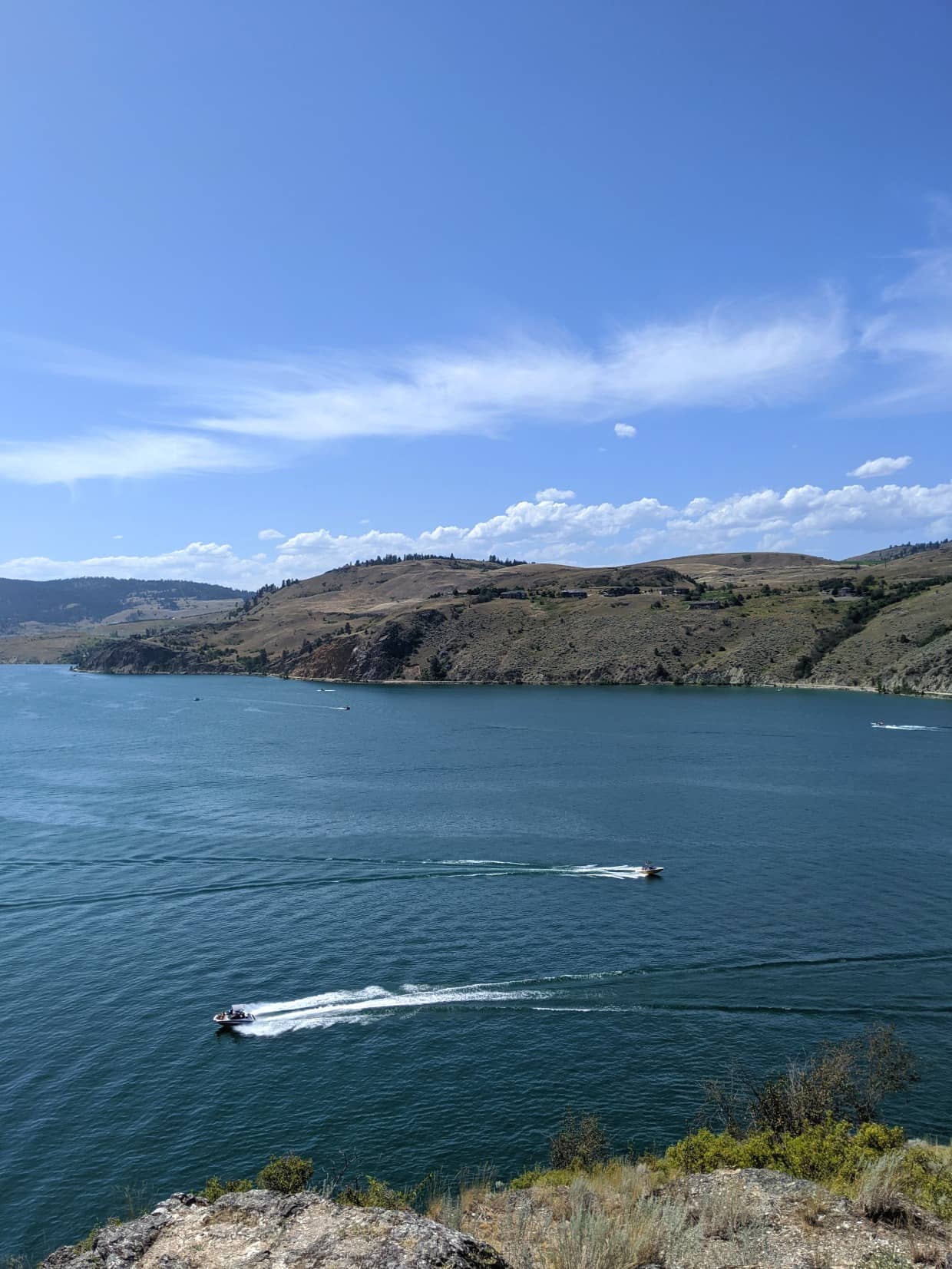
Okanagan Lake Lookout Loop, Predator Ridge
Length of hike: 3km loop
Trail condition: Some short ascents/descents on dirt paths (steep at times), rocky sections
Trailhead location: Birdie Lake Drive, Predator Ridge
Facilities: Maps, navigational signs
Predator Ridge is a golf resort community located just south of Vernon. Though that may initially sound like an odd place to go hiking, it all makes sense when you see the spectacular setting above Okanagan Lake. There are over 35km of well maintained multi-use trails on this 1,200 acre resort.
The Okanagan Lake Lookout Trail is our top pick for a quick (one hour) hike. This 3km circuit also takes in views of Predator Ridge Resort itself. Rated as ‘difficult,’ this trail does have some steeper sections (with loose rock) but they never last long. The payoff is definitely worth it.
It would be easy to extend your hike at Predator Ridge, with many of the trails intersecting. Click for a complete guide to the best Predator Ridge trails.
After your hike, consider a late breakfast or lunch at the Range Lounge. This casual restaurant, overlooking part of the golf course, serves upscale cuisine using local ingredients when possible. It’s a gorgeous setting, matched by excellent food.

Ridgewalk, Silver Star Ski Resort
Length of hike: 2km one way
Trail condition: Downhill dirt trail, narrow in parts and featuring loose rock
Trailhead location: Summit of Silver Star Ski Resort
Facilities: Maps, navigational signs (washrooms and other facilities in village)
For some of the most breathtaking views in the Vernon area, consider a trip to Silver Star Ski Resort to hike the Ridgewalk Trail.
Continuing on from the Attridge Scenic Loop at the top of the mountain, this hiking trail features extensive wildflower meadows as well as sweeping panoramas of the Okanagan Valley and Monashee Mountains on a clear day.
The village elevation is 1,609m, which usually means that Silver Star is a few degrees cooler than Vernon. This makes Silver Star a practical place to go hiking when it’s just too hot in town!
The Des Scheumann Summit Express Gondola runs on summer weekends and provides a shortcut to Silver Star’s alpine trails (no uphill hiking required!)
On Monday, Thursday or Friday, there’s the option of taking the Comet Express (additional hike required) or hiking all the way up and down the mountain. If you choose the latter, be sure to pick up a complimentary hiking trail day ticket first.

Okanagan Rail Trail
Length of hike: As far as you like!
Trail condition: Wide path, almost entirely flat, can be dusty
Trailhead location: Various
Facilities: Washrooms, kilometre markers, bins
Once utilised to bring the produce of the Okanagan Valley across the country, the discontinued Kelowna Pacific Railway line is now the area’s most exciting recreation project – the Okanagan Rail Trail.
Thanks to the low grade of the railway, the path is resoundingly flat and wide all the way along. This enables excellent accessibility for everyone.
As well as connecting communities (and providing a link to the past), the 52km route between Coldstream and Kelowna also showcases some stunning Okanagan scenery.
The section closest to Vernon follows the shore of Kalamalka Lake, offering hikers an opportunity to see the wildlife as well as the distinctive colours of the water.
Use this excellent Google Map to help you plan a hike or bike rail on the Okanagan Rail Trail. Kekuli Bay Provincial Park is one of the access points. If you start at the northern terminus, consider a stop at the Rail Trail Cafe for locally roasted coffee as well as freshly baked cakes and pastries.

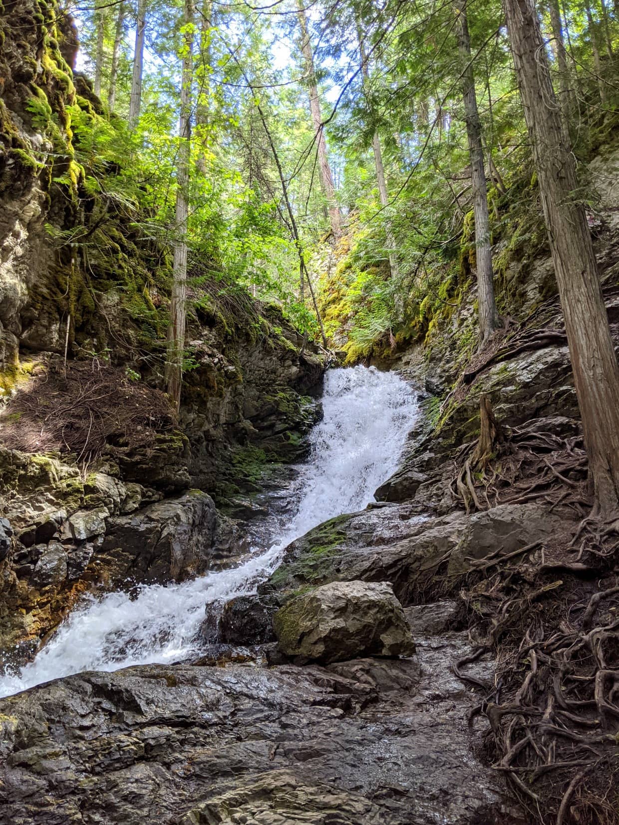
BX Falls
Length of hike: 700m out and back
Trail condition: Mostly flat, 60+ stairs to view waterfall
Trailhead location: Tillicum Road
Facilities: None
Culminating in a surging waterfall, this short Vernon hiking trail has an excellent reward to effort ratio.
From the trailhead, simply follow the creek 350m to the top of a staircase. BX Falls lies in a cool canyon below. The water flows from Silver Star Mountain and can be raging in spring.
Shaded by forest and kept fresh by the creek, this hiking trail is perfect for hot summer days. The trip to BX Falls is very popular with families.
If you’re looking for a longer hike, climb back up the stairs and continue along the trail. The path follows the creek downhill, steeply at times.
The 3.3km long trail to the Star Road trailhead can get washed out in winter/spring. Maintenance closures are relatively common.
Loop Trail, Swan Lake Nature Reserve
Length of hike: 1.8km loop
Trail condition: Almost entirely flat, damp in places
Trailhead location: Off Old Kamloops Road
Facilities: Interpretive boards, signage
Shallow and marshy, Swan Lake is an important wetland area. Over 200 species of birds are found here, as well as many amphibians and mammals.
This interpretive loop trail offers the chance to spot some of these creatures in their native habitat. There is a viewing platform located approximately half way along the trail.
While this short Venon hike stays a respectable distance from Swan Lake itself, the surrounding views are still worth the time to see. Depending on the time of year, there can be beautiful wildflowers growing along the trail. Flooding is common in May and June.
Despite being only a few minutes from from downtown Vernon, the Swan Lake area is exceptionally peaceful. On that note, it’s important to know that dogs are not allowed on this trail.

Nature Trail, Ellison Provincial Park
Length of hike: 2.9km loop
Trail condition: Dirt-packed surface with some rocky sections, some short ascents/descents
Trailhead location: Ellison Provincial Park day use parking lot
Facilities: Maps, navigational signs, outhouses at start/end
This family friendly trail in Ellison Provincial Park is both scenic and educational, featuring interpretive signage and panoramas over Okanagan Lake.
The hike starts with a climb up to a bench and reveals stunning views. It then turns away from the lake and meanders through a ponderosa pine and Douglas-fir forest.
The trail ends in the campground section of the park, so simply walk along the road back to the day use parking lot.
A popular extension to this Vernon hiking trail is to continue on to Otter Bay. At the end of the downhill trail, you’ll find a large crescent-shaped beach with picnic area.
From here, winding trails lead along the rocky headlands to South Bay, another stunning beach.

Grey Canal – Silver Star Foothills Loop Trail
Length of hike: 2.3km loop
Trail condition: Wide path, with dirt-packed surface, some short ascents/descents
Trailhead location: Blackcomb Way or Rugg Road parking lots
Facilities: Signage, maps, bins, benches
The Silver Star Foothills Trail, part of the Grey Canal Trail, forms a narrow oval shaped loop, with one length elevated above the other.
The higher length (approx 1.1km long) provides wonderful panoramas of Swan Lake, the city of Vernon and even Middleton Mountain. There interpretive signs along the route
The loop can be enjoyed when hiking in either direction. There’s also a choice of parking lots, with Blackcomb Way being the southeast trailhead (higher) and Rugg Road the northwest trailhead (lower).
Visiting in fall? This Vernon trail has some lovely autumnal colours, especially in late October.

Grey Canal – Davison Orchards view
Length of hike: 1.6km out and back
Trail condition: Wide path, with dirt-packed surface, mostly flat
Trailhead location: Parking lot at end of Sierra Road
Facilities: Signage, maps, bins, benches
This short stroll on the Grey Canal showcases Vernon’s agricultural side, with a backdrop of the downtown area and Bluenose Mountain beyond (the peak in the background of the photo below).
If you time it right in fall, you’ll even be able to spot Davison Orchard’s pumpkin patch.
The trailhead for this hike is situated at the end of Sierra Road, off Crosby Road. There is a dedicated parking lot.
The most popular hike from this location is actually in the western direction – the Bella Vista / Okanagan Hills section of the Grey Canal (7km return). It features sweeping views of Okanagan Lake.
We didn’t have quite enough time to fit this trail in on our last visit but it’s top of the list for the next!

Coyote Loop, Thomas Hayes Ecological Park
Length of hike: 4.3km
Trail condition: Wide dirt paths, small amount of elevation gain/loss
Trailhead location: Thomas Hayes Road, between Vernon and Armstrong
Facilities: Signage, bench
Although the Coyote Loop is a little out of Vernon, I’ve decided to include it as I think it is a great choice for anyone wanting a straightforward walk in the woods. It seems to be very popular with local dog walkers.
Thomas Hayes was a local farmer in the early 20th century. His family continued farming here until the 1960s, before donating the land to the province of BC in his memory. What a wonderful gift – especially as the property borders Otter Lake and has a great diversity of plants, wildlife and trees.
The trail network in the park is small but there are a few options to choose from. The Coyote Loop stays close to the perimeter for the main part and passes through a beautiful open meadow area. It has about 80m of elevation gain total.
One of my favourite aspects of this trail is how quiet it is. Not just in terms of other visitors, but just ambient noise in general.
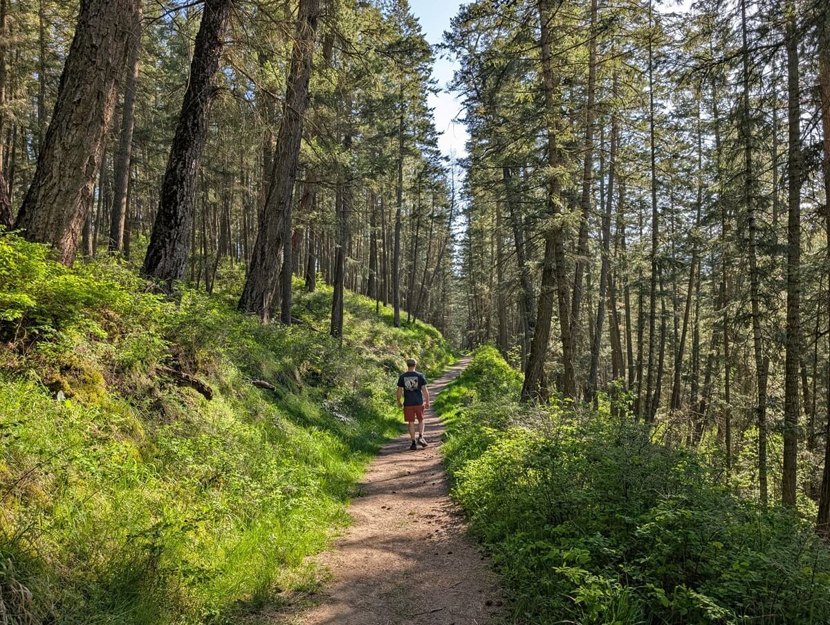
BX Creek Delta Trail
Length of hike: 3km out and back
Trail condition: Almost entirely flat, boardwalk sections
Trailhead location: 20th St and 48th Ave, on-road parking
Facilities: Signage, maps
If you’re looking to stretch your legs while in the middle of Vernon, the BX Creek Delta Trail offers a great solution. It’s unquestionably an urban path but provides a pleasant shady escape.
Starting near the corner of 20th St and 48th Ave, this boardwalk trail follows the creek through surprisingly dense forest, emerging occasionally to cross a few streets. You emerge from the woods a few times to cross a few streets.
The most northern part of the trail (near Rona) has been relocated for construction. For this reason, I’d recommend turning around at the corner of 20th St and 52th Ave at the current time.

Essential tips for hiking in Vernon
- Remember to Leave No Trace when visiting any of these Vernon hiking trails. This means staying on trail at all times and taking care to pack out everything you bring in (including trash)
- Most of these trails are exposed, with very little shade. When hiking in Vernon during the summer, be prepared to start early (before 9am) for a more comfortable experience
- Be sure to bring plenty of water, sunscreen and a sunhat to stay cool during the warmer months
- April, May, September and October are great hiking months in Vernon, with cooler temperatures and quieter trails
- Remember to do a tick check after hiking, especially during the spring and summer months. We have never personally seen any ticks in the Vernon area but I am sure they are there!

- All of these Vernon hikes are within cell phone range but it’s still a good idea to tell someone where you’re going as well as your expected return time
- Poison ivy is present on some of these Vernon hikes – know how to identify and avoid (look for the three leaves)
- Leashed dogs are allowed on most these trails – follow all signage and be careful to pick up after your dog
- Rattlesnakes are present in the Vernon area and can occasionally be seen on trails. Carefully detour around them and continue. These rattlesnakes are not aggressive and will only strike as a last resort

Where to eat (and drink) after your Vernon hike
For breakfast and brunch, my top pick has to be Eatology in downtown Vernon. It’s a modern yet cosy place, where all of the Canadian classics are made with fresh, local ingredients. The Caprese (pesto, tomato and mozzarella) eggs benedict has to be one of my all time favourites anywhere.
An awesome option for lunch on the trail is a charcuterie board from Wedge Cheesery.
Available for one, two or four people, the ‘to go’ picnic box includes several specially selected cheeses, crackers, fruit, nuts and locally made condiments. Meat can be added too. The highlight of our box was the Saint-Nectaire, a nutty French semisoft cheese.
Treat yourself after a hike with a trip to Cambium Cider. Set alongside the orchard, the Cambrium Cider patio and garden is the perfect place to relax with a cold glass of cider.
Tasting flights are available, as well as wood fired oven pizza (Thursday-Sunday). I loved the drier, understated British style ciders but I think there would be something for most tastes.
Beer lovers will love Silverstar Brewing (downtown) and BNA Brewing. The latter has bowling and a huge patio. For more restaurant recommendations, head to our Vernon food guide.

Where to stay in Vernon
I’d recommend the Prestige Vernon Lodge for anyone visiting Vernon from out of town. Featuring a three story tropical atrium and natural creek, it’s like nowhere else I’ve ever stayed in Canada!
A restaurant, indoor pool and hot tub sit in the middle of it all. Only the pool is open at the moment, but I imagine that this would be a particularly wonderful place to hang out in the winter.
The location of this hotel is excellent for anyone looking to get out and explore Vernon and the surrounding area.
The highway provides quick access to all of the Vernon hiking trails mentioned here. There are a number of restaurants and bars within a couple of blocks and downtown Vernon is a short 15 minute walk down the street.

Check out these other Okanagan posts next:
Predator Ridge Hiking: Best Trails + Essential Info
A Local’s Guide to the Best Okanagan Valley Wineries
Hiking the Myra Canyon Trestles near Kelowna
74 Things to Do in Penticton and the Southern Okanagan
11 Fast and Fun Hikes in Penticton
12 Fast and Fun Hiking Trails in Merritt


One half of the Canadian/British couple behind Off Track Travel, Gemma is happiest when hiking on the trail or planning the next big travel adventure. JR and Gemma are currently based in the beautiful Okanagan Valley, British Columbia, Canada. Consider buying us a coffee if you have find any of our guides helpful!
I like very much Vernon is amazing!