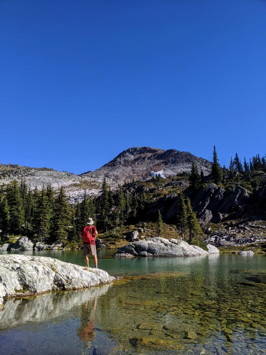
Two gorgeous aquamarine alpine lakes set into a mountain bowl, sparkling in the summer sun. This is Twin Lakes, a tranquil hiking destination in the Monashee Mountains near Cherryville, British Columbia.
The hike to Twin Lakes is ideal for adventurous hikers looking for a spot of solitude in the mountains.

This post will tell you everything you need to know about hiking to Twin Lakes near Cherryville, BC. It includes:
Please remember to Leave No Trace to help keep the wilderness wild. Twin Lakes does not currently have park protection.

Twin Lakes
Location: Cherryville, BC
Distance: 8km return
Elevation gain: 400m
Hike type: Out and back
Time: 3-4 hours (with a break at the lakes)
Difficulty: Moderate
Camping: Yes but no facilities
Fees: None
When to go: Late July to mid-September


Backcountry necessities
- Always bring the 10 Essentials
- Know how to stay safe in the backcountry
- Understand how to avoid negative bear encounters
- Recommended gear is listed on our Shop page
- Need a packing list? Sign up to our newsletter for a free one!
This post includes affiliate links. If you make a purchase via one of these links. I may receive a percentage of the sale at no extra to cost you.

Twin Lakes
Not only does the hike to Twin Lakes feature a spectacular destination, but the journey is pretty great too.
The views open up quickly, offering spectacular panoramas of the trail ahead, layered mountain valleys and distance snow capped peaks.

The total trail distance is short but features a number of steady climbs, sure to make you sweaty on a warm day.
The ascents are punctuated by beautiful subalpine meadow sections. In the peak of the summer season, these meadows burst with colour from wildflowers.
Besides the initial climb, the biggest challenge of this hike is getting to the trailhead, located at 1800m. The final approach is pretty nail-bitingly rough, which makes the arrival to the parking lot that bit sweeter!

Exploring the Monashees
The mountains backdropping beautiful Twin Lakes are part of the Pinnacles, a small cluster of rocky summits belonging to the Monashee range.
The Monashees stretch from Valemount (near Mount Robson) all the way into Washington, across the border.
This isn’t the only accessible hike in the Pinnacles. There are half a dozen other wonderful hikes in the area, with Twin Lakes often being cited as the easiest. On the same road trip, we visited Pinnacle Lake.
There’s also a challenging route along the spine of Pinnacles called the Mark Berger Traverse. It connects 6-7 different peaks and offers breathtaking panoramas of alpine lakes, snow capped summits and more.
Other Monashee Mountain adventures:
- Spectrum Lake, Monashee Provincial Park
- Little Peters Lake and Big Peters Lake, Monashee Provincial Park

Twin Lakes: Hike Experience
The 8km return hike to Twin Lakes starts with a wooden plank-assisted crossing of a muddy patch by the parking lot. Beyond the planks, a clear path heads uphill through the forest. It’s time to climb!

The first 1.3km features an uphill ascent, with around 220m elevation gained along the way. The rocky trail dips in and out of the trees. Some of the more open sections offering views over the surrounding mountains (yes, views already!)

Eventually, the path flattens out and reveals a beautiful, open area. where mountains rise above the surrounding trees.

Welcome to the subalpine
At the 1.7km mark, the trail drops steeply and quickly down to a meadow. This descent is only a loss of 30m or so but the path is uneven and crumbly with loose rock and dirt.

Enjoy the flat section while it lasts as another steady climb is coming (around 130m). After this, the views really open up as the meandering path parallels a ridge.
Some short uphill sections lead the trail a little further away from the ridge. Around a wide corner and the aquamarine colours of the lakes start to appear through the trees below.

Arriving at Twin Lakes
The final approach is downhill. The gradient is occasionally steep, with some parts featuring loose rock. The last slope leads directly to the smaller of the two lakes.

There are multiple defined paths to explore, including one that completely encircles the larger lake. Rocks and boulders provide plenty of opportunities to sit and take in the beautiful sparkling lakes.
If you have the time and skills, it’s possible to extend your adventure with some off route hiking and scrambling to the surrounding peaks and ridges.
The return route to the parking lot is via the same trail.

Twin Lakes Trail Planning Guide
Inspired to check out Twin Lakes yourself? Read on to discover everything you need to know about this beautiful hiking trail near Cherryville, BC.
When to hike the Twin Lakes Trail
The best time to hike to Twin Lakes is from early August to mid-September.
The trailhead is at 1800m, so snow can linger well into July. Depending on the winter snowpack, it may also be possible to hike into Twin Lakes earlier in the season (mid/late July).
But for the best chance to avoid snow, aim for the time frame mentioned above.
If you like wildflowers, visit earlier rather than later (August). Hiking during the second week of September, it was a bit too late for wildflowers on our visit.

How to access the Twin Lakes trailhead
The Twin Lakes trailhead is located on an offshoot of the North Fork Forest Service Road, east of Cherryville, British Columbia.
Cherryville is an easy (and paved) 45 minute drive from the city of Vernon. From Cherryville, it took us around 50 minutes to reach the Twin Lakes trailhead.
- For navigation to this trailhead, I’d highly recommend the Kootenay Rockies Backroad Mapbook (Twin Lakes is just off the edge of the Thompson Okanagan one)
- Exit Highway 6 on North Fork Road, the northern access route to Cherryville. Follow North Fork Road through the community, passing the Cherryville Emporium.
- 7km after leaving Highway 6, you’ll reach a crossroads. Turn left to continue following North Fork Road, which eventually becomes North Fork Forest Service Road
- The Twin Lakes parking lot is located at GPS coordinates 50.282358,-118.310233
Before you go, I’d recommend checking All Trails to see if any hikers have reported any recent road closures due to logging.
2022 update – I have heard through various hiking groups on Facebook that the North Fork Forest Service Road is very rough to drive this year. 4X4 high clearance highly recommended
Driving the FSR
The FSR is an industrial road, meaning that it is privately maintained and not paved.
The condition of industrial roads is pretty variable as it depends on the amount and type of work going on in the area at the time (if any).
Industrial vehicles always have priority on industrial roads. Be prepared to pull over quickly to give way at all times. This road may occasionally be closed to non-industrial traffic. Be prepared to drive slow.
On our visit in September 2020, the first 10km or so was fairly easy to drive, being in decent condition (no debris, few potholes), reasonably wide and flat-ish.
After 13km, the road starts to gain elevation and becomes gradually rougher as it winds its way up to the trailhead (900m elevation gain).
The final 4km is the roughest section of all. The surface is uneven and rocky, with occasional debris. The road is quite narrow with some tighter switchbacks. Please see 2022 update above.
I would definitely recommend using a high clearance vehicle, though you should still be prepared for it to potentially receive some minor damage (body scratches for example). We were very happy to finally arrive at the parking lot!
In September 2020, there was one picnic table and a rustic rock fire pit in the parking lot area.

Navigating the trail
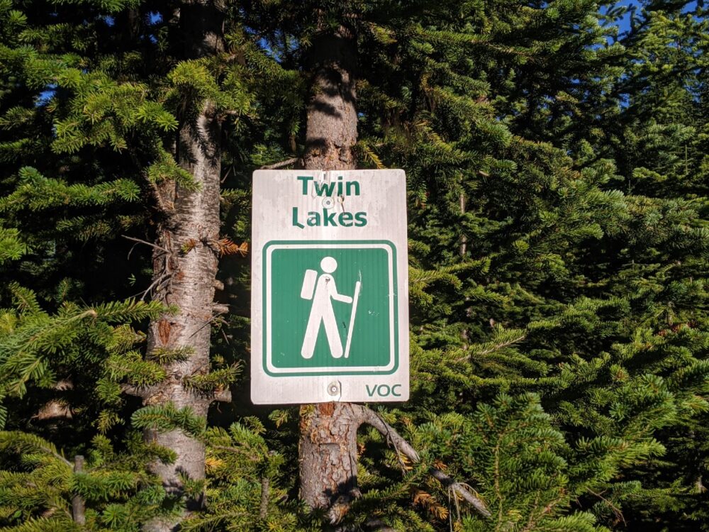
The start of the Twin Lakes Trail is marked in the parking lot with a large green and white hiking sign. On our visit, there was also some pink flagging in the trees.
From here, some wooden planks lead across a muddy area towards the forest and to the established trail.
During the main hiking season, the Twin Lakes Trail is clearly defined for almost the entire route.
The only exception is a very short downhill section after the initial climb from the parking lot (as described above). The steep, rocky nature of this quick descent means that the route is less defined.
Having said all this, it’s still important to pay attention to the path and have a map of the hike. There is no signage along the trail.
Maps.me is our go-to app for on-trail navigation and this trail is marked, although not named. You can follow it (look for the white dotted line) from the parking lot at GPS coordinates 50.282358,-118.310233

Trail difficulty and hazards
I would rate this hike to be moderate in difficulty. It’s definitely not a walk in the park but it’s not technically difficult either.
- The first 1.3km is almost entirely uphill, with 220m of elevation gain
- This initial ascent will likely leave you out of breath (especially if you’re carrying an overnight backpack), but regular breaks will help
- One trickier part on this hike the abrupt descent before the meadows (as described in the hike experience section above)
- The final approach down to the lakes is steep and slippery in sections, so watch your footing here too

Hikers should be aware that grizzly bears live and roam in this area. Be careful to stay alert at all times.
There are some sections in which it would be more difficult to spot or hear a bear (and vice versa) so be sure to make noise along the way, have your bear spray handy and know how to react if you do see a bear.
- Please note that there is no phone signal at the trailhead, along the trail or at the Twin Lakes
- Before heading out to the Twin Lakes trailhead, be sure to let someone know where you are going and when you plan to be back (check out our outdoor safety guide for more tips)
- There is no water along the trail, besides the lakes at the end. Bring a water filter to properly purify water here

Camping at Twin Lakes
While there is no established campground at Twin Lakes, the location is regularly used for overnight camping.
There are no facilities at all, only cleared tent areas and rock fire pits.
This area is completely user maintained, meaning that the responsibility of keeping the campsite clean is on campers.
It is therefore absolutely crucial to follow Leave No Trace principles to protect the pristine beauty of Twin Lakes and the wildlife that live here.
To do this, you should be prepared to pack out everything you brought in, camp on durable surfaces, minimise campfire impacts and be careful to dispose of human waste properly.
Following these simple steps ensures that the Twin Lakes area remains clean, beautiful and accessible for everyone.
Camping overnight at Twin Lakes offers the opportunity for further exploration of the surrounding area. I’ve read quite a few trip reports that feature hikers climbing up to the ridge above the lakes. Route-finding skills are needed for this.

Essential items to bring
- The 10 Essentials: Slight inconveniences (changes in weather, injuries, other unexpected events) can easily turn into life-threatening emergencies in the backcountry – bringing the 10 Essentials will help prevent this from happening
- Hiking poles – I found it helpful to have hiking poles on this trail, especially during the downhill sections. Incredibly light and foldable, Black Diamond’s Carbon Z poles are my tried and tested favourite pair. I usually bring both poles but only use one
- Bear spray – With Twin Lakes’ location and level of isolation, bear spray is an absolute must when hiking this trail. Be sure to store it somewhere handy using a holster. We carry one bear spray each on trails like this
- Leave No Trace supplies (trash bags, trowel etc.) – As mentioned above, there are no facilities anywhere on the Twin Lakes Trail. This includes the camping area and parking lot
- Fly and mosquito repellent – Although we had no issues in mid-September, I’ve heard that flying insects can be a problem earlier in summer. Be sure to bring your favourite repellent!
For gear and clothing recommendations, head over to our Shop.

Other local hiking trails
Pinnacle Lake near Cherryville (we combined this with Twin Lakes)
Spectrum Lake, Monashee Provincial Park
9 Fast and Fun Hikes in Vernon
The Best Predator Ridge Trails, near Vernon
Gimli Peak and Gwillim Lakes in Valhalla Provincial Park
Eva Lake in Mount Revelstoke National Park

PIN this post for future reference with the above image


One half of the Canadian/British couple behind Off Track Travel, Gemma is happiest when hiking on the trail or planning the next big travel adventure. JR and Gemma are currently based in the beautiful Okanagan Valley, British Columbia, Canada. Consider buying us a coffee if you have find any of our guides helpful!