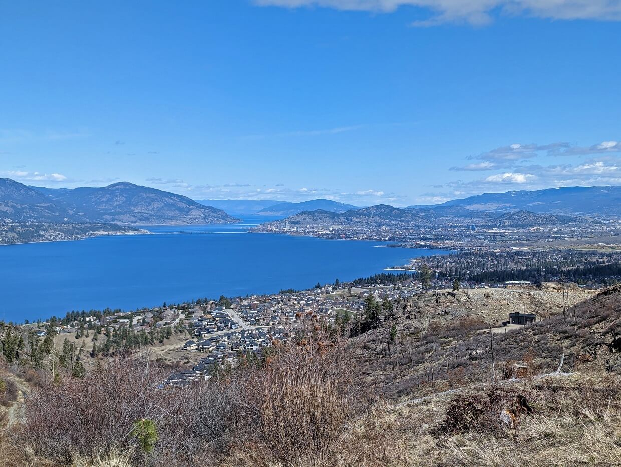
Whether you’re seeking a leisurely stroll alongside Okanagan Lake or an adrenaline-pumping trek up one of the local mountains, Kelowna has hiking trails for everyone.
And better still, the majority of Kelowna hiking trails come with a spectacular view of the golden Okanagan Valley landscape.
Living in nearby Penticton, we are regular visitors to the Kelowna area. And I have to admit, I’m a bit jealous of Kelowna’s extensive network of trails.
Not only are the routes plentiful but they are well signed, easily accessible and surprisingly varied too.
This post reveals all of our favourite quick Kelowna hiking trails, ranging from easy rail trail paths to more challenging mountain routes. I’ll also share some essential tips for safe hiking in the Okanagan Valley.
Here’s the complete list:
- Walking trails
- Easy and moderate hiking trails
- Apex Trail, Knox Mountain
- Scenic Canyon
- Turtle Pond Trail
- Elk/Crags Loop, Johns Family Nature Conservancy
- Lebanon Creek Greenway
- Canyon Rim Trail
- Kalamoir Loop
- Rose Valley Scenic Loop
- McDougall Rim Hiking Trail
- Mount Boucherie Rush
- Big Sagebrush Trail
- Mountain Goat Trail
- Pincushion Mountain
- Spion Kop summit
Hiking necessities
- Always bring the 10 Essentials
- Know how to stay safe in the backcountry
- Remember to Leave No Trace to help keep the wilderness wild
- Understand how to avoid negative bear encounters
- Recommended gear is listed on our Resources page
- Need a packing list? Sign up to our newsletter for a free one!
Finding Kelowna hiking trails
The map below features all of the featured Kelowna hiking trails.
The mentioned trails are located in the city of Kelowna itself and also in West Kelowna, Peachland and Lake Country.
I’ve divided this post into walking trails and easy/moderate hiking trails to provide a varied range. Although I personally love the challenge of moderate level hikes, I like to alternate with straightforward walking trails.
The majority of these featured trails are snow free from mid April to early November (depending on recent weather conditions). Expect some mud in March and April.
Please be sure to read the ‘essential tips’ section before heading out for a hike. Even if you’re regular hiker elsewhere, hiking in the Okanagan Valley comes with some unique challenges!
Kelowna and West Kelowna are located on the traditional territory of the Syilx Okanagan.
This post includes affiliate links. If you make a qualifying purchase through one of these links, I may receive a small commission at no extra cost to you.
Easy walking trails
Let’s start with some easy Kelowna walking trails! The following are very flat, cleared trails, with minimal elevation gain.
Paul’s Tomb
Length: 4.8km return with 140m elevation gain
Difficulty: Easy, featuring wide cleared path with gentle ascent on return journey
Trailhead location: First Lookout parking area, Knox Mountain
Facilities: Outhouse at start and midpoint, benches, signage
I’ll start this list with the classic Kelowna hiking trail that is Paul’s Tomb. Starting from the First Lookout parking area, the path curves around the base of Knox Mountain to a pretty pebble beach backdropped by crystal clear water.
Spectacular views of Okanagan Lake can be seen throughout the hike. The trail descends just over 100m to reach Paul’s Tomb.
While this does mean that the return journey is uphill, it is a gentle ascent on a wide cleared path (no tree roots or rocks). There are a number of benches and viewpoints along the way, providing plenty of potential rest areas.
The First Lookout parking area is open 12:00pm to 8pm during spring to fall season. Before and after that time (and when the parking lot is full), you’ll need to hike to the trailhead from the main parking area. This adds 2.2km return and 90m elevation gain when hiking on the road.
As for the trail’s name, the Paul family moved to Kelowna in 1905, the same year that it became a city (total 600 population). Pioneering patriarch Rembler built a tomb at the beach (30m above Okanagan Lake) to house his family after their passing.
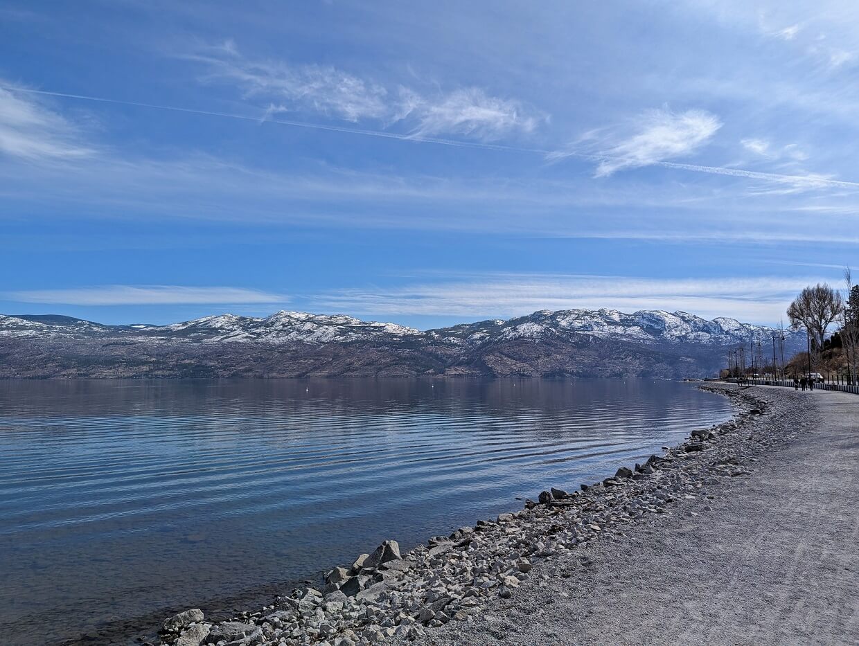
Waterfront promenades
Length: Varies, see below
Difficulty: Very easy, featuring completely flat, wide paved path
Trailhead location: Various, see below for details
Facilities: Benches, washrooms, playgrounds, trash bins
Kelowna’s waterfront promenade stretches 2km from Rotary Marsh Park to the Highway 97 tunnel. The very wide, paved path passes beaches, sports fields, manicured lawns, playgrounds, statues and more as it follows the edge of Okanagan Lake.
The only downside of this pleasant waterfront walk? Finding a parking spot can be tricky in this busy area and also cost up to $2/hour.
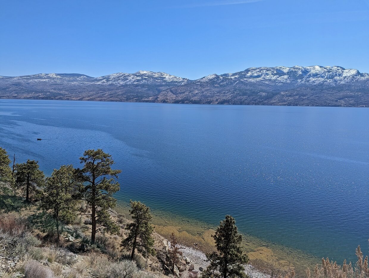
The Gellatly Bay waterfront promenade in West Kelowna is a good free alternative. This wide, paved path offers views of Mount Boucherie and Okanagan Mountain Provincial Park as well as Okanagan Lake. Parking can be found along Gellatly Road itself.
The best section is from Willow Beach to Gellatly Dog Beach, a distance of 1km. It is possible to extend the walk in both directions. A highlight of the route is the restored CNR Wharf, now used as an Aquatic Park.
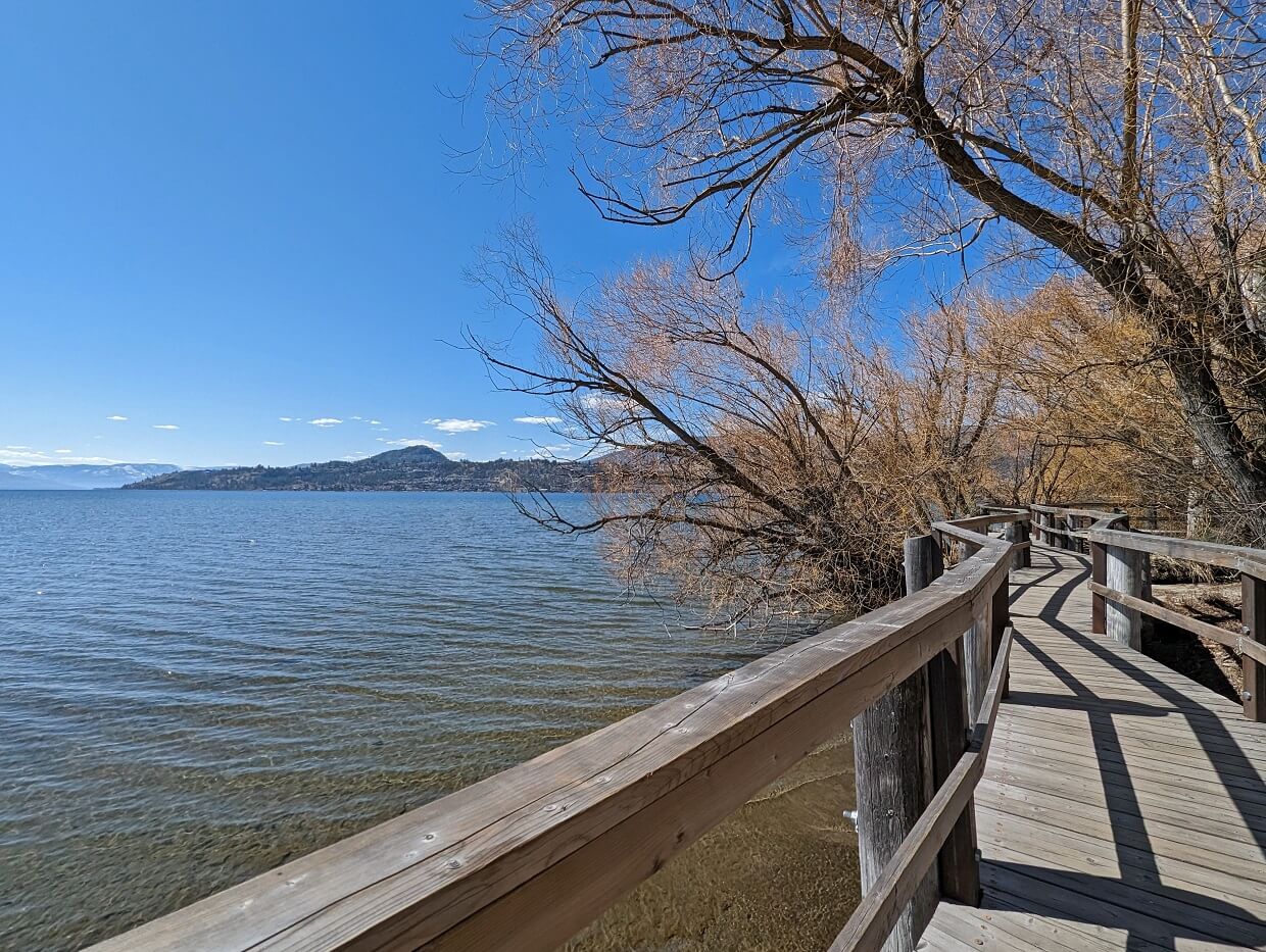
Sibell Maude-Roxby Wetlands Boardwalk
Length: 700m return
Difficulty: Very easy
Trailhead location: End of Francis Avenue, Kelowna
Facilities: Boardwalk, trash bins
The Sibell Maude-Roxby Wetlands Boardwalk showcases one of the last remaining marsh habitats on the shoreline of Okanagan Lake. A short boardwalk trail travels across fragile marsh plants and through a poplar forest to the lake, via a number of viewing platforms.
A huge range of birds, including some rarer species (White Pelicans, American Avocets) can potentially be seen here. For this reason, dogs are not allowed.
While this Kelowna hike is certainly more of a walk and a very short one at that, I included it for variation. The Sibell Maude-Roxby Wetlands provides an important insight into a lesser seen Okanagan Valley ecosystem.
This Kelowna hiking trail is also perfect for families with strollers, wheelchair users and other people with reduced mobility. Please note, however, that there isn’t a lot of parking on this block of Francis Avenue (3/4 spots only).
Dilworth Lookout
Length: 1km loop, minimal elevation gain
Difficulty: Easy, featuring well established, mostly flat dirt path
Trailhead location: Chilcotin Crescent, Kelowna
Facilities: Playground, benches, porta potty in parking lot
For the most scenic yet effortless hike in Kelowna, head directly to the Dilworth Lookout.
A small network of interconnected trails provide access to panoramic views of Kelowna’s residential and commercial areas, backdropped by Knox Mountain and Okanagan Lake.
The Dilworth Lookout is immediately adjacent to a residential area, so this is definitely more of an urban hike than a wilderness one. Having said that, it is surprising how peaceful it is here.
If you’re looking for a little more challenge, nearby Dilworth Mountain Park features a number of loop trails leading to Mount Dilworth’s summit. A water tower sits at the highest point.

Mission Creek Greenway
Length: Varies – 2km route suggested below
Difficulty: Described section is very easy with completely flat, wide path
Trailhead location: Mission Creek Regional Park, Springfield Road
Facilities: Washrooms, picnic area, interpretive signage, playground
Mission Creek is one of the most significant waterways in the Okanagan Valley. Originating near Big White Mountain, Mission Creek winds its way through southern Kelowna to Okanagan Lake. It actually accounts for more than 25% of Okanagan Lake’s inflow waters and is also the main Kokanee spawning channel.
When finished, the Mission Creek Greenway Trail will provide a riverside (or adjacent) path all the way from Okanagan Lake to Mission Creek Falls, a total distance of 26km.
One of the most accessible sections of the Mission Creek Greenway is situated in Mission Creek Regional Park. This part of the Greenway parallels the north side of the creek and features a very wide, completely flat cleared gravel multi-use path. It is suitable for strollers, wheelchairs and bikes.
For an easy stroll at any time of year, I would suggest starting at the main Springfield parking lot and walking 1km east. Cross the bridge and return to the parking lot via the Soopollalie Trail (narrower dirt path). There is another bridge opposite the parking lot. Visit in fall to watch the kokanee run in the creek.
Mill Creek Waterfall
Length: 1.8.km return
Difficulty: Very easy, with
Trailhead location: Mill Creek Regional Park, Spencer Road
Facilities: Outhouse near trailhead, trash bins, signage
The airport area may seem like a strange destination for a hike, but Mill Creek is Kelowna’s most accessible waterfall. The completely flat 900m approach follows the river and is shaded by the trees, making it a good choice on warmer days.
The trail splits just before the falls. A higher trail leads past the cascade while the lower trail heads to the base of the waterfall, where the water bursts out between large rocks above the creek. The cascade is pretty strong in spring.
The area below is the falls is rocky, with many small pools. Mill Creek is a very popular place to wade during the hot summer months. Despite this, it is still possible to spot animals in this area as it is a wildlife corridor.
There are more waterfalls further up the creek, but the trail beyond the first is more difficult and prone to washouts.

Myra Canyon Trestles
Length: Varies, suggested route is 8km return trip with no elevation gain
Difficulty: Very easy, featuring well maintained, completely flat gravel trail
Trailhead location: Myra Station, 25km from downtown Kelowna
Facilities: Outhouses in parking lot and en-route, benches, interpretive signage
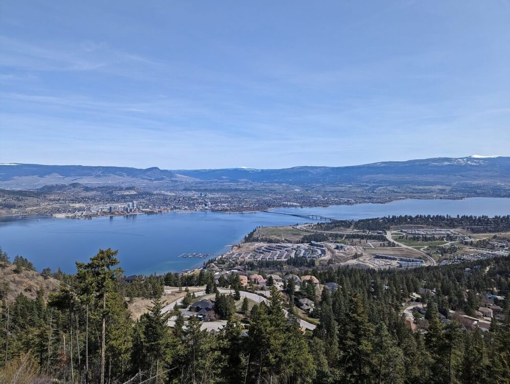
Myra Canyon Trestles, without a trestle, is Kelowna’s most famous hiking trail. Part of the converted Kettle Valley Rail (KVR) Trail, the Myra Canyon section features 18 magnificent wooden trestle bridges.
Ranging up to 220m in length, these wooden railway bridges are a sight to behold. With Myra Canyon being located at 1220m, the views from the trestles are pretty spectacular as well.
There are two main access points for Myra Canyon, with Myra Station being the best option for walkers. A 8km return trip (4km each way) takes in 13 bridges and two tunnels.
It is important to note that snow is usually present in Myra Canyon from mid October to late April (weather dependent). Temperatures are also significantly cooler than in Kelowna. The access road to Myra Station is not paved.
For all the details, check out our Myra Canyon Trestles guide

Moderate level Kelowna hiking trails
Time to up the difficulty level a little. The following trails are easy and moderate hiking trails, 100-500m of elevation gain, narrower paths and rocky sections.
Apex Trail, Knox Mountain
Length: 4.2km return
Difficulty: Low side of moderate, with steady uphill ascent (260m elevation gain)
Trailhead location: End of Ellis Street, Kelowna
Facilities: Outhouses, trash bins, signage, interpretive displays, gazebo shelter
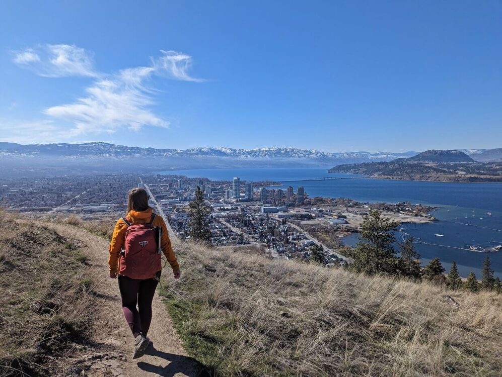
Another Kelowna classic, the Apex Trail is a go-to workout hike for many local residents. The well used trail switchbacks its way up the side of Knox Mountain, rewarding hikers with spectacular views of Kelowna and Okanagan Lake.
The best vistas are found at the summit area, but you really don’t have to hike far to see a great view. For this reason, the Apex Trail is ideal for reluctant or novice hikers.
On the downside, this Kelowna Trail isn’t the best choice if you’re looking for solitude. It’s busy. To add to that, part of the hike is accessible by road. Until recently, it was actually possible to drive all the way up to the summit area.
For a longer hike, consider combining this trail with Paul’s Tomb. There is a connector trail partway down, before the official Paul’s Tomb trailhead by the First Lookout parking area.

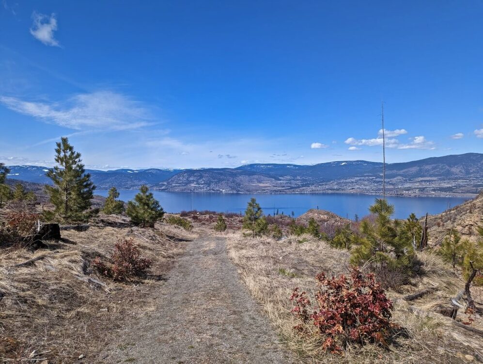
Scenic Canyon Rock Ovens and Layer Cake Hill Viewpoint
Length: 3.5km return with 120m elevation gain
Difficulty: High side of easy with two steady uphill climbs
Trailhead location: End of Field Road (turn right into gated parking lot)
Facilities: Signage, porta potty in parking lot, interpretive displays
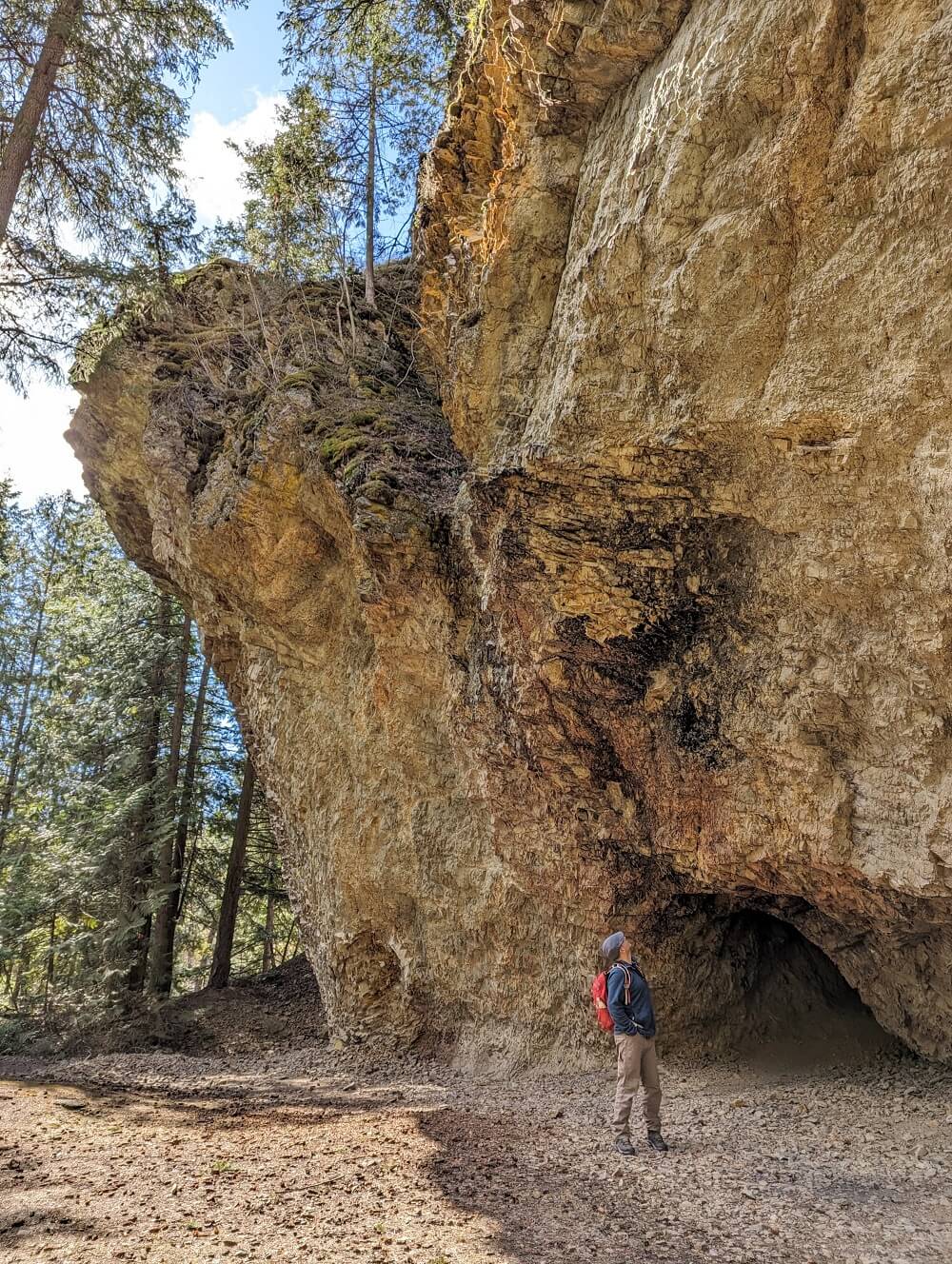
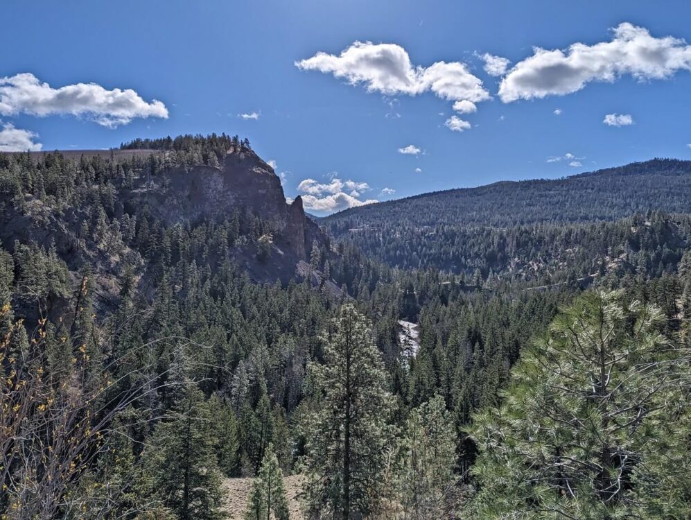
The Scenic Canyon area is one of the most unique places to go hiking in Kelowna. There are a number of unique geological formations to see, a result of ancient volcanic activity and more recent glacial melt.
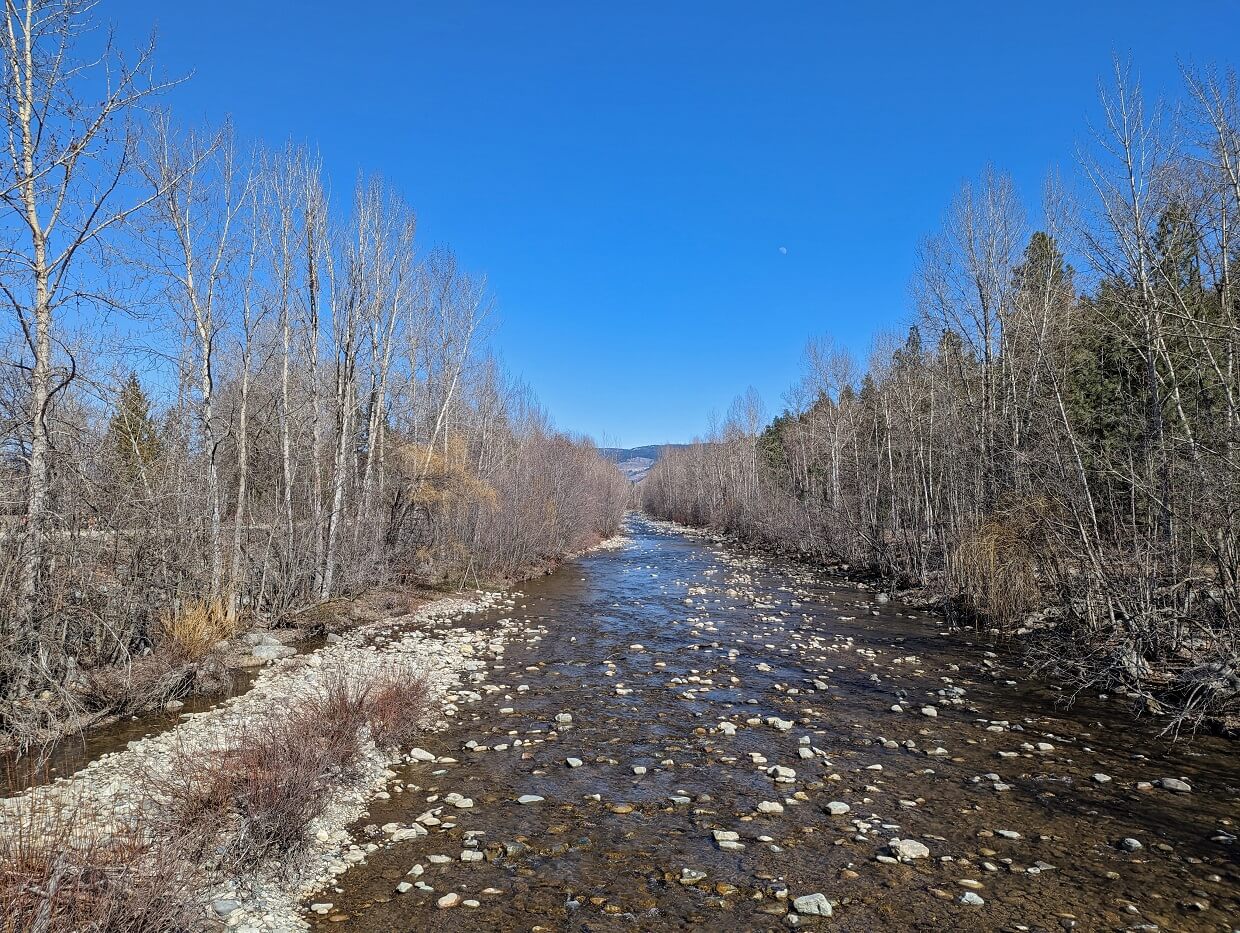
Follow the downhill switchback trail from the Field Road parking lot down to Mission Creek. Turn left to head towards the Rock Ovens.
These naturally formed caves were used by Chinese gold miners for refuge in the 19th century. Some interesting honeycomb-like rocks can be seen further along the river as well.
The final destination of this hike is a lookout that unobstructed views across to impressive Layer Cake Hill. This huge rock formation looks exactly as it sounds!
To reach the lookout, return to the Rock Ovens junction and continue another 500m (and 50m elevation gain) on the Mission Creek Greenway. There is a picnic shelter at the top.
While this Kelowna hiking trail does feature an uphill climb back to the parking lot, it is a fairly gentle grade and the path is very wide. The surface is not always level however, with some rocks and tree roots.
Turtle Pond Trail
Length: 1.1km return, many longer routes possible
Difficulty: Easy, with cleared path and minimal elevation. Some stairs
Trailhead location: Mission Creek Regional Park, Springfield Road
Facilities: Signage, benches plus washrooms, picnic area and playground at trailhead
The Greenway isn’t the only reason to visit Mission Creek Regional Park. This popular urban park provides a surprisingly amount of solitude, especially considering it is only a couple of blocks away from a large mall!
Mission Creek Regional Park features 7km of walking paths, including the easy Turtle Pond Trail. This short trail can be hiked by itself or as part of a longer route.
Starting at the main parking lot, head across the bridge (look for the kokanee running in fall!) and then up the stairs on the other side. The wide dirt trail leads through the forest to a beautiful pond area. Try to spot the turtles from the bridge.
To return, follow the same route or take the service road back down to the creek (take a left at the first intersection after the pond). For a longer hike, complete the Sutherland Hills Loop (additional 1.5km with 50m elevation gain).
Elk Trail/Crags Loop, Johns Family Nature Conservancy
Length: Varies, suggested route is 3.3km loop with 90m elevation gain
Difficulty: High side of easy, with narrow and wide path, steady ascent
Trailhead location: Chute Lake Road, Kelowna
Facilities: Interpretive signage, outhouse en-route, benches
Perched high up in the hills of southwestern Kelowna, the Johns Family Nature Conservancy Regional Park protects a number of important wildlife habitats.
Brother and sister Alfred and Nancy Johns donated this parcel of land to the Central Okanagan Land Trust to ensure the protection of this beautiful area of land for years to come.
There are a few different route options in this park. My top pick is a 3.3km loop starting on the Elk Trail. Spectacular views are revealed almost right away, as the trail heads west towards Okanagan Lake. There is a well placed bench at the bottom of the hill.
Turn right at the Crags intersection. Here, a huge rock formation parallels the path. There may be some climbers ascending to the top. The trail slowly and steadily climbs up to meet the top of the Lebanon Creek Trail. Turn left at the Elk Trail intersection to return to the parking lot.
I have rated this Kelowna hiking trail as easy, but it is on the harder side of that rating due to the elevation gain and some narrow and rocky sections. Please note that the final 1km road section to the parking lot is not paved, but seems fairly well maintained.
Due to the conservation nature of this park, it is important that dogs are kept on a leash at all times
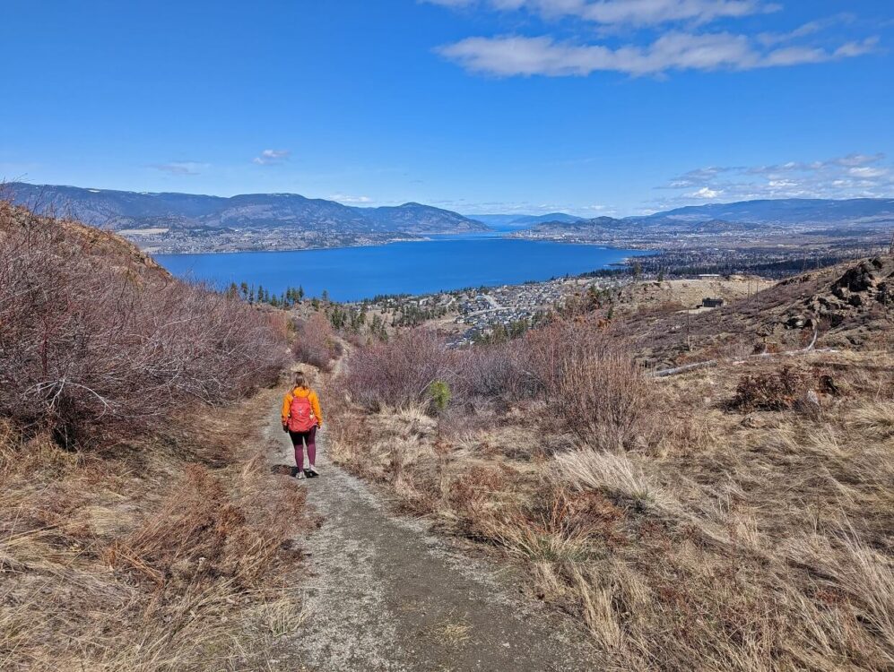
Lebanon Creek Greenway
Length: 6.4km
Difficulty: Moderate, with continual incline (430m total elevation gain) and steep sections
Trailhead location: Lakeshore Road
Facilities: Signage
Looking for a good workout? The Lebanon Creek Greenway will deliver! Starting with stairs, the trail is uphill almost the entire way. When you need a break, turn around and take in the sweeping views of Okanagan Lake.
With a subdivision on one side and more construction in progress, this Kelowna hike isn’t a jaunt in the wilderness. And you have to like the burn. But the views are gorgeous and the path well maintained. It’s usually pretty quiet too.
If you still have energy left, combine this trail with the Elk Trail/Crags Loop in Johns Family Nature Conservancy Regional Park.
Note that this Kelowna trail is very exposed, so be sure to start very early (or late) on sunny summer days or save it for a cooler day.
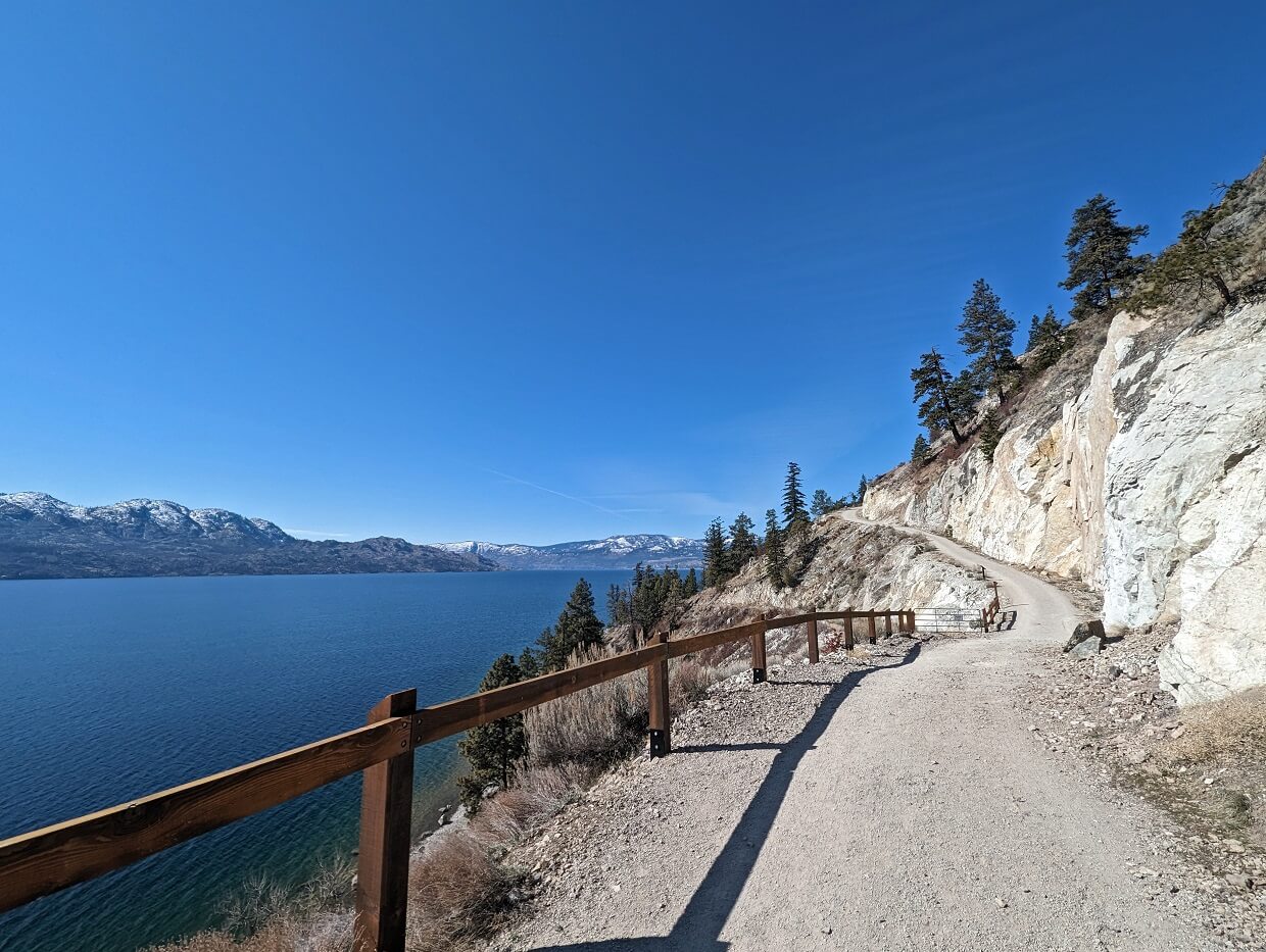
Canyon Rim Trail, West Kelowna [closed]
Length: 2.3km loop
Difficulty: Low side of moderate, with two steady climbs, narrow section with drop-off, some loose rocks
Trailhead location: Westside Road, West Kelowna
Facilities: Outhouse in parking lot, trash bins, signage
Please note: This trail is closed due to damage from the 2023 wildfires
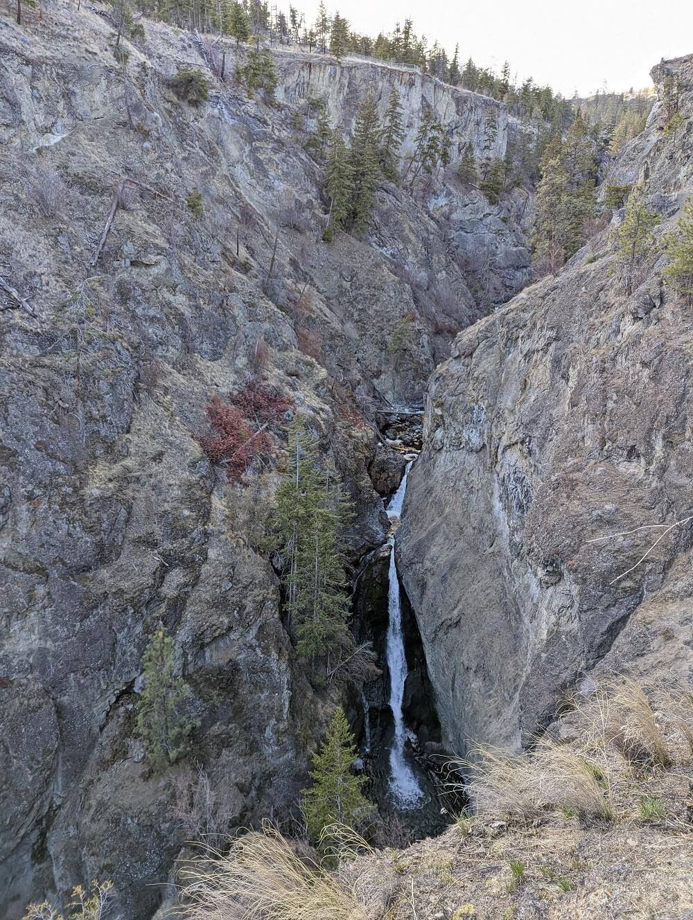
Part of Bear Creek Provincial Park, this Kelowna hiking trail travels along the edge of a steep canyon to reveal dizzying views of the creek below.
There are a few options for routing here, with my favourite being a combination of the Canyon Rim Trail and the Mid Canyon Trail. In my opinion, the latter is more scenic than the continuation of the Canyon Rim Trail (extra 300m).
I prefer hiking counter clockwise, but either way is fine. Two big ascents are necessary either way, as the trail winds down to a wooden bridge crossing at the far end of the creek.
A large waterfall can be seen on the northern side of the loop, about 460m from the trailhead.
The viewpoints on the southern side offer spectacular canyon views, though the main waterfall is a bit hidden from this perspective. Smaller waterfalls can be spotted further upstream.
The Canyon Rim Trail is the easiest Kelowna hiking trail within this ‘moderate’ section (I found it hard deciding where to place it). Be sure not to underestimate the two big climbs, however, especially in warm weather.
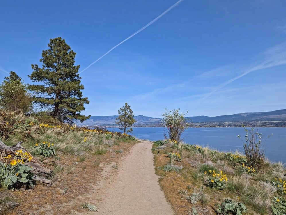
Kalamoir Loop Trail, West Kelowna
Length: 2.7km loop
Difficulty: High side of easy, with 90m elevation gain
Trailhead location: Collens Hill Road, Kalamoir Regional Park
Facilities: Outhouses, signage, benches
This short, scenic and surprisingly challenging hike is located next to Okanagan Lake in West Kelowna. Kalamoir Regional Park also features multiple beaches, swimming area and kayak dock.
This loop route is a combination of the Sunnyside Trail, Upper Rim Trail and Waterfront Trail. Superb views of the lake can be seen on each section of the hike.
The Sunnyside Trail starts to climb immediately from the parking lot (look up to spot some caves!), with the Upper Rim Trail completing the journey to the highest point of the trail.
I suggest hiking this loop clockwise, to ascend the steepest section of the trail rather than hike down it. This direction also means that the uphill part is finished first.
The best time to hike this trail is in late April/early May, when the Arrowleaf Balsamroot are in bloom. The southern side of the loop is lined by these native sunflowers and therefore absolutely bursts with colour at this time of year.
Rose Valley Scenic Loop, West Kelowna [closed]
Length: 7.9km (+1.2km, see below)
Difficulty: Low side of moderate, with mostly wide, forested trail and 230m elevation gain
Trailhead location: Westlake Road
Facilities: Portapotty in lower parking lot, trash bins at trailheads, benches at most viewpoints, signage
Please note: Most of this trail network is currently closed due to damage from the 2023 wildfires. Limited sections re-opened in winter 2024/5. For more details, check the park’s website (link below).
Rose Valley Regional Park is host to an impressive network of multi-use trails, ranging from short jaunts to challenging full day hikes.
This particular hiking trail is a combination of the Yellow Bell Loop, Forest Loop and the Bitterroot Loop. The winding path takes in six incredible viewpoints which showcase the city of Kelowna and Okanagan Lake as well as Rose Valley Reservoir and Mount Boucherie.
The route starts on the Yellow Bell Loop, which is mostly uphill. Luckily, it is forested for the most part. The Forest Loop is more gentle but has one shade-less section. The Bitterroot Loop travels through the forest in one direction and along a rocky ridge in the other. The latter offers the best views but has no shade.
On our last visit, in late April 2023, the upper Westlake Road parking lot (near the pond) was inaccessible due to a road closure. We parked at the lower parking lot, near Starlight Crescent, and hiked the Bunchgrass Trail to connect with the main loop (0.6km each way).
There is a shorter version of this loop, involving a steeper ascent to the Bitterroot Loop. Personally, I like the longer hike route as the climb is steadier. I also appreciate the signage as the network of trails here can be confusing!
McDougall Rim Trail, West Kelowna
Length: 7km return (longer options possible)
Difficulty: Moderate, continual ascent, some steeper and rockier sections, 400m elevation gain
Trailhead location: Bartley Road, West Kelowna
Facilities: None
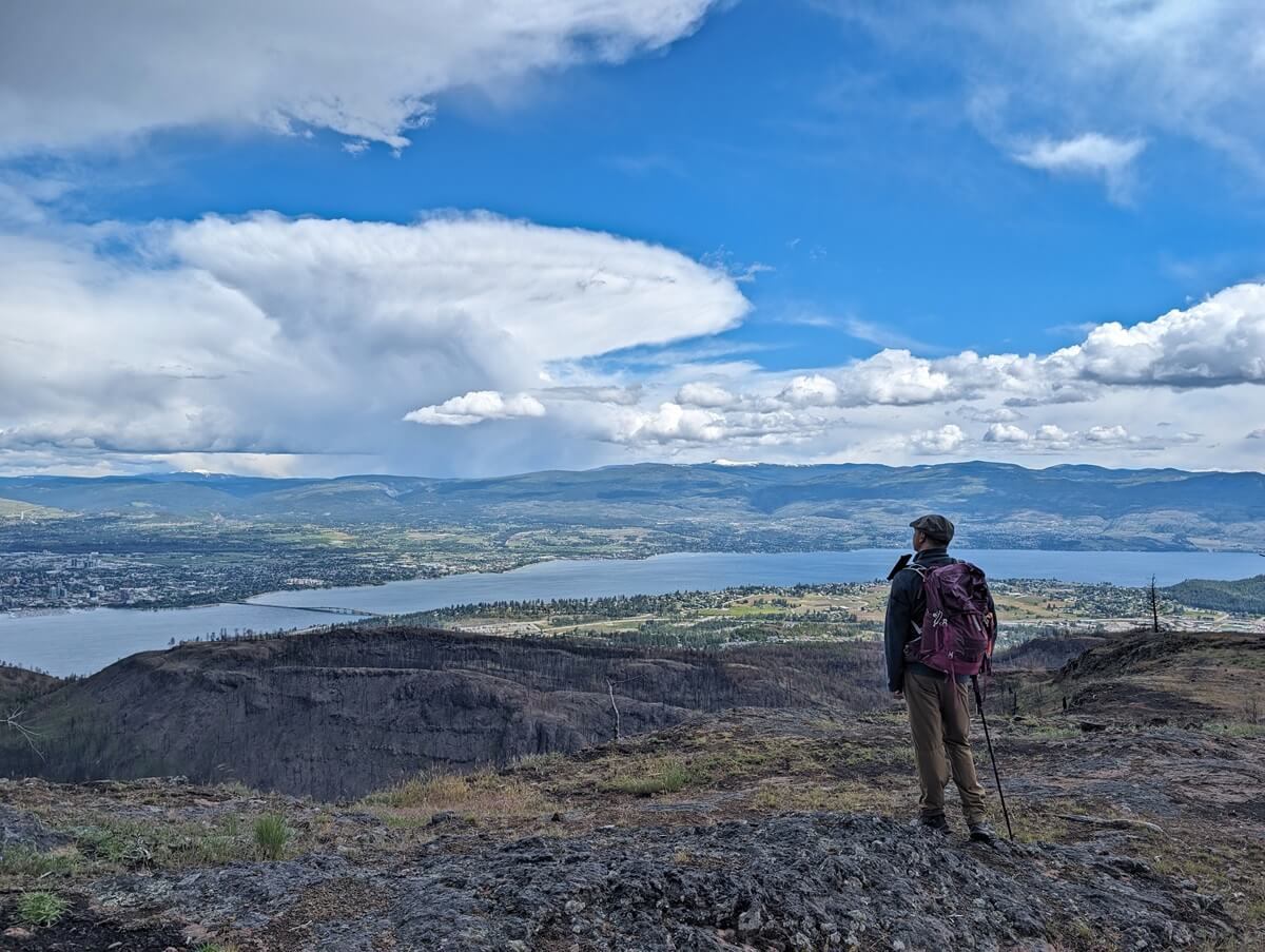
The 2023 McDougall Creek Wildfire was the largest wildfire in West Kelowna’s history. The McDougal Rim Trail passes right through the wildfire area, along the ridge above Rose Valley (see above).
Hiking the Rim Trail post-wildfire is a very different experience than it once was, with the burned trees now providing much wider views across to Kelowna and Okanagan Lake. Wildflowers bloom and there are plenty of green shoots.
We recently hiked a short version of the McDougall Rim Trail in 2024, the easiest route to a rocky area overlooking Rose Valley Lake.
The path is generally quite wide and features a couple of switchbacks. It is uphill all the way, with some steeper, rocky sections. The sweeping views are certainly worth the grind!
To find this path, head to the furthest right of the trails leading from the parking area. I’d recommend using the All Trails routing to stay on track as there is no signage anywhere.
Please be cautious when planning to hike this trail. Avoid windy days. Stay on the trail, away from the burned trees. There is very little tree cover now, so be careful with skin protection (hat, sunscreen etc.)
Mount Boucherie Rush Trail, West Kelowna
Length: 6km return
Difficulty: Low side of moderate, continual ascent with switchbacks, 300m elevation gain
Trailhead location: East Boundary Road, West Kelowna
Facilities: Portapotty and trash bin at trailhead, picnic bench at summit, signage
The Mount Boucherie Rush Trail has one of the best effort to reward ratios of any hiking trail in the Kelowna area. It’s also acts as a great training hike for longer and more difficult hikes.
Most of the route to the 758m high summit consists of switchbacks. But these are the ‘easy’ kind, with long, mostly flat sections between corners. Gorgeous views of West Kelowna and Okanagan Lake appear almost right away, so there’s plenty to look at.
Keep in mind, however, that the vistas are so good because there are very few trees. That means zero shade as well. Be sure to start this trail very early in summer or choose a more shaded hike.
On the final approach, the trail swings around to the forested northern face of the mountain, providing panoramas of downtown Kelowna as well as the Rose Valley. The rocky summit area faces the other direction.

Big Sagebrush Trail, West Kelowna
Length: 2.6km return
Difficulty: Easy, featuring wide cleared path and reasonably gentle ascent on return (80m elevation gain)
Trailhead location: Seclusion Bay Road, West Kelowna
Facilities: Signage at trailhead, outhouse, benches, trash bins and signage at turnaround point
Curving around the base of Goat’s Peak in West Kelowna, the Sagebrush Trail offers sweeping views of Okanagan Lake. Situated at the Highway 97/97C intersection, this trail is convenient for travellers passing through the area.
The gorgeous panoramas begin right from the parking lot, which makes this trail an easy sell for reluctant hikers. Most of the first half of the hike is all downhill, which does mean that the return journey is, of course, uphill.
Despite this, I would still class this trail as easy because the ascent is reasonably gentle and on a very wide, cleared trail. It is also relatively short and so should be approachable for most.
The turnaround point of the Sagebrush Trail is at the start of the Mountain Goat Trail, signified by interpretive signage, benches and an outhouse. The trail does technically continue to Whitworth Road.
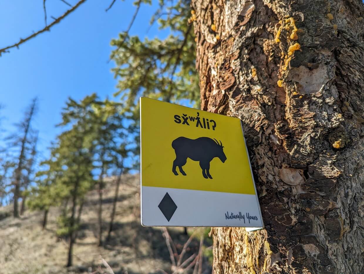
Mountain Goat Trail (Goats Peak), West Kelowna
Length: 3.2km plus 880m/2.6km*
Difficulty: Moderate, featuring steep sections and 250m total elevation gain
Trailhead location: Seclusion Bay Road OR Whitworth Road, see below
Facilities: Outhouse, signage, trash bins, viewing platform and bench at summit
The climb to the summit of Goats Peak will surely make you feel a little like a mountain goat at times! Luckily, it is as rewarding as it is steep. There are spectacular views of Okanagan Lake, West Kelowna and Mount Boucherie almost all the way along.
Some of the switchbacks lead directly to flat viewpoints, perfect for taking in the views and also for getting your breath back. The best vistas are found at the summit itself, where a wooden platform provides an ideal spot for an extended break.
On the way down, be careful with your footing. The steeper sections of the Mountain Got Trail are very dusty, with small loose rocks. A hiking pole can be very helpful to have on this Kelowna hiking trail.
*The Mountain Goat Trail is accessed via the Big Sagebrush Trail, which has two trailheads. The Seclusion Bay Road trailhead is located to the southwest, with the Whitworth Road access to the northeast. The Seclusion Bay Road trailhead has more parking, though the hike from Whitworth Road is shorter (440m vs. 1.3km).

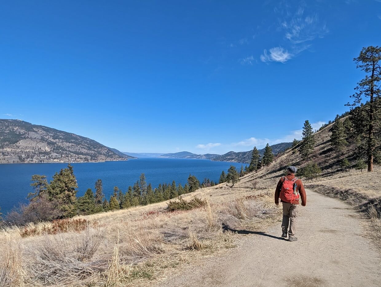
Pincushion Mountain, Peachland
Length: 4km return
Difficulty: Low side of moderate, trail features some rocky sections, steep drop-offs and 245m elevation gain
Trailhead location: End of Ponderosa Drive, Peachland
Facilities: Outhouse in parking lot during main hiking season, picnic table at summit
For a short yet challenging hike, you can’t really go wrong with Pincushion Mountain in Peachland.
Gorgeous views of Okanagan Lake and rugged Okanagan Mountain Provincial Park are the reward for completing the relatively steep ascent up to the 815m summit.
The current name of the mountain dates back to the 19th century, when a wildfire swept through this area and left very few trees standing. As a result, the mountain looked like a pincushion from afar!
The Pincushion Mountain trailhead is only a few minutes drive from Highway 97, so it is a good pick for anyone travelling through the area. Due to the elevation gain and lack of shade, be sure to start early during the summer months.
For all the essential details, check out our Pincushion Mountain trail guide

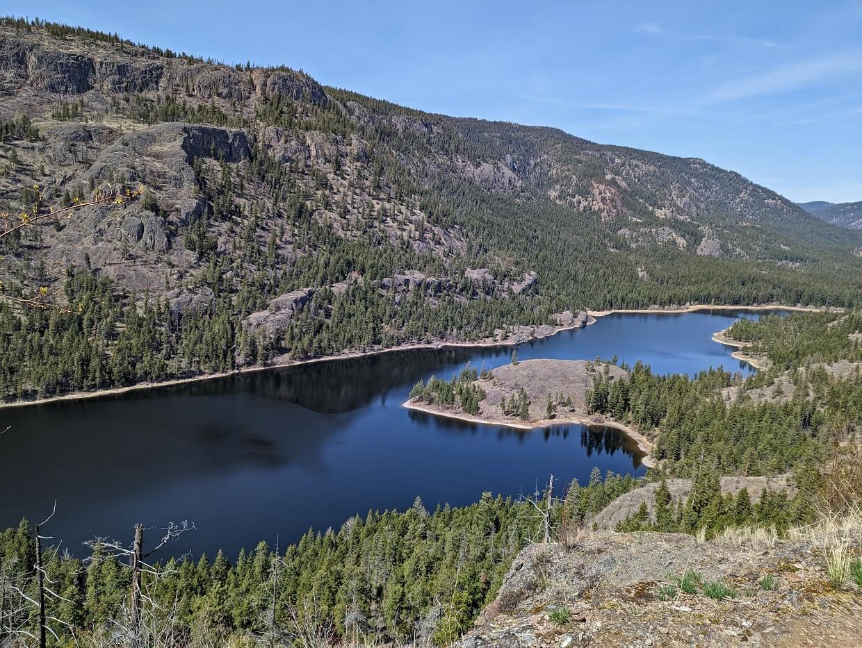
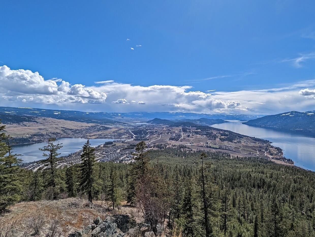
Spion Kop summit, Lake Country
Length: Varies, 5.2km return route described below
Difficulty: Moderate, with uphill climb featuring some short, steep sections and 270m elevation gain
Trailhead location: Just off Derek Trethewey Drive, Lake Country
Facilities: Picnic bench at trailhead and summit, signage
Named after the Dutch term for ‘look out hill,’ Spion Kop is a 350 hectare ridge located between Okanagan Lake and Wood Lake. An exceptional network of well signed trails sprawls across the ridge, the impressive work of the Walk Around Lake Country volunteer group.
The interconnecting trails provide almost endless hiking opportunities. Our favourite route starts at the Upper Lakes Trailhead and travels to the 879m high summit, via the Arrowleaf Trail, Connector and Summit Trail.
The ascent is pretty steady all the way, with switchbacks in places. The final ascent (after the Tower Trail intersection) becomes steep, narrow and uneven with a short rock stair section.
Two peaks await at the summit, one topped with microwave tower and picnic bench. We prefer the other ‘hump,’ which is adorned with basalt rocks.
The summit vistas, as you may guess, are breathtaking, with views of four lakes (Okanagan, Ellison Wood and Kalamalka) and surrounding mountains.
Essential tips for hiking in Kelowna
- All of these Kelowna hikes have cell phone signal but it’s still a smart idea to tell someone where you’re going as well as your expected return time
- Most of these trails have good trailhead signage, with some directional signs along the route. Having said that, it’s remains important to pay attention to the trail. This post is intended to be a starting point, not a definitive guide. We utilise AllTrails and Organic Maps for navigation on these Kelowna trails
- Remember to Leave No Trace of your visit on any these beautiful Kelowna hikes. This means staying on trail at all times and taking care to pack out everything you bring in (including trash)
- A must on any challenging trail, hiking poles have many benefits (balance, impact reduction, endurance, speed). We usually share a pair of collapsible, superlight Black Diamond Carbon Z hiking poles
- Unless posted otherwise at the trailhead, leashed dogs are allowed on these trails. Please be careful to pick up after your dog
Weather
- When hiking during the summer months in Kelowna, be prepared to start early (ideally around 8am or earlier) to beat the heat
- Many of these Kelowna hiking trails are very exposed, with very little shade – bring plenty of water, sunscreen and a hat. We use and recommend Just Sun sunscreen, made by a small business in Kelowna!
- In my opinion, March April, May, September, October and November are the best months to hike in Kelowna. The lower elevation trails will be free of snow at this time, plus temperatures are cooler and there are less people around as well
Wildlife and nature
- Black bears, rattlesnakes, deer, bighorn sheep and other animals live on and around these trails. Take appropriate precautions, stay alert, make noise and keep your distance from wildlife
- We personally carry bear spray on every single trail we hike. If you decide carry some, learn how to use bear spray properly first
- Ticks are common in the Kelowna area, especially in spring. Cover up, avoid grassy areas where possible and check your clothing (and body) after hiking
- Poison ivy can be found on some of these Kelowna hiking trails – make sure you know how to identify it
Where to stay in Kelowna
The Hotel Zed is a renovated motel situated right across from Kelowna City Park, which borders Okanagan Lake. The rooms are cleverly designed with a modern yet funky aesthetic.
Guests have access to a number of great amenities, such as a rooftop patio, hot tub, swimming pool and even a table tennis room.
For a more upscale stay in Kelowna, check out The Royal Kelowna. This luxurious resort is also less than five minutes walk from Okanagan Lake. All suites have well equipped kitchens. The star of the show is an infinity pool on the roof.
The Coast Capri Hotel is a reliable chain hotel pick, with easy access to downtown and wineries. There are two on-site restaurants as well.

Other Okanagan Valley articles you may find helpful
15 Fast and Fun Hikes in Vernon, British Columbia
Predator Ridge Hiking: Best Trails + Essential Info
Enderby Cliffs Trail (Tplaqin): Complete Hiking Guide
16 of the Best South Okanagan Hiking Trails
The Best Okanagan Valley Wineries: A Local’s Guide
A Local’s Guide to Craft Breweries in Penticton
22+ of the Best Campgrounds in the South Okanagan
82+ Things To Do in Penticton and the Southern Okanagan


One half of the Canadian/British couple behind Off Track Travel, Gemma is happiest when hiking on the trail or planning the next big travel adventure. JR and Gemma are currently based in the beautiful Okanagan Valley, British Columbia, Canada. Consider buying us a coffee if you have find any of our guides helpful!
Hello Gemma, Is there a trail connecting Knox Mountain Apex with Glenmore? I realize I could literally just stay in the visual range of the city…I will definitely hit Carrot Mountain this spring/summer. When I do Apex, I literally begin at the tennis courts and go straight up to the first gazebo and utilize short cuts and game trails to make it more difficult to the upper lookout, then down to Paul’s tomb using a game trail from the first bench, then Lockview trail to the road. I wish it picked up somewhere above there…I think I’ll trek Stevens Coyote Ridge today (first time). I’ve lived in Kelowna for 4 years and completed most of the trails in the area.
Hi Brett,
To be completely honest, I’m not sure. Do you have a favourite trail in the Kelowna area?