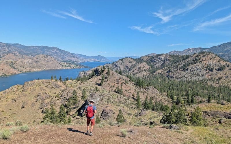
High in the hills east of Kelowna is a walk/bike ride like no other. Beautiful Myra Canyon is home to 18 trestle bridges along the abandoned Kettle Valley Railway.
Ranging up to 220m in length, these wooden railway bridges are a sight to behold. The views from them are not half bad either, looking down towards Kelowna and Okanagan Lake.


Visiting Myra Canyon in autumn offers an even more special experience. The changing colours somehow manage to enhance the wonderful views of the surrounding landscape as well as the intricate trestles themselves.
Hiking the Myra Canyon trestles is definitely not an experience to miss while in the Kelowna area! Keep reading to discover more about the hiking experience and everything you need to know to visit the trestles yourself.

Here’s what to expect in this post:
- Myra Canyon: A quick history
- Location
- The best time to go
- Trailheads
- Hiking
- Biking
- Tours and bike rentals
- Essential information
There are affiliate links in this post. If you make a qualifying purchase through one of these links, I may receive a small commission at no extra cost to you.

Backcountry necessities
- Always bring the 10 Essentials
- Know how to stay safe in the backcountry
- Remember to Leave No Trace to help keep the wilderness wild
- Understand how to avoid negative bear encounters

Myra Canyon: A quick history
The Kettle Valley Railway (KVR) was a line built to serve mining interests in BC’s Southern Okanagan region from 1915-1989. It stretches from Midway to Hope, BC.
Since converted into an epic 500km+ long (with extensions) multi-use recreational trail, the maximum 2.2% grade of the KVR is perfect for leisurely bike rides and effortless strolls.
Myra Canyon, a long and wide chasm with several creeks running along it, proved to be difficult obstacle to cross for the railway planners.

The elevation is also the highest on the entire KVR route, at 1274m. 18 bridges (called trestles) and 2 tunnels were required to complete this tricky section of the KVR.
This incredible engineering achievement continues to be appreciated today by the thousands of walkers and cyclists who visit Myra Canyon every year.
Indeed, the Myra Canyon section is the most popular of the entire KVR route. Be sure to arrive early if visiting in the summer.
Read more: Walking the KVR Trail in Penticton, BC

The Okanagan Mountain Park fire
Varying in height from 8 to 55m, the Myra Canyon trestles each have a different vantage point around the valley and across to the other trestles.
The longer trestles are my favourite as they have little viewing points jutting out into the canyon. These convenient viewing stands were actually used when the railway was active to store water containers in case of fire!

Sadly not all of the Myra Canyon Trestles are the original versions. 12 of the 18 trestles in Myra Canyon caught fire during the devastating 2003 Okanagan Mountain Park fire despite a multitude of efforts to save them.
Rebuilt by BC Parks and volunteers using government funding, most of the trestles were returned to their former glory by 2008. The Myra Canyon Restoration Society raised money for the maintenance of these intricate structures till 2022. Friends of the South Slopes (FOSS) are now in charge of the trestles and trail system.
2 of the 18 trestles are made from steel rather than wood. They’re still pretty picturesque though.

Hiking the Myra Canyon Trestles: Visit Guide
In this section, I’ll share everything you need to know about visiting the Myra Canyon Trestles, including location details, accessibility, bike rentals and more.
Where are the Myra Canyon Trestles?
The Kettle Valley Rail Trail runs from Midway to Hope, British Columbia. For the most part, it is a well maintained, flat gravel trail suitable for people of all abilities.
The Myra Canyon trestles are located along a section of the KVR Trail close to the city of Kelowna. There are two main entrances, Myra Station (east) and Ruth Station (west).
It takes about 40 minutes to drive to either Myra Station (25km) or Ruth Station (23km) from downtown Kelowna. Keep reading for more details.
Be careful to Leave No Trace when exploring nature – don’t feed wildlife, take home everything you brought with you and stick to the trails at all times! Stay away from edges of the trail and trestles to avoid the steep dropoffs

The best time to visit Myra Canyon
Myra Canyon is open to visit year round, but snow is usually present on the trail from mid October to late April. The relatively high elevation (1200m) also means that temperatures are significantly cooler than in Kelowna.
The most popular time to visit Myra Canyon is May to September.
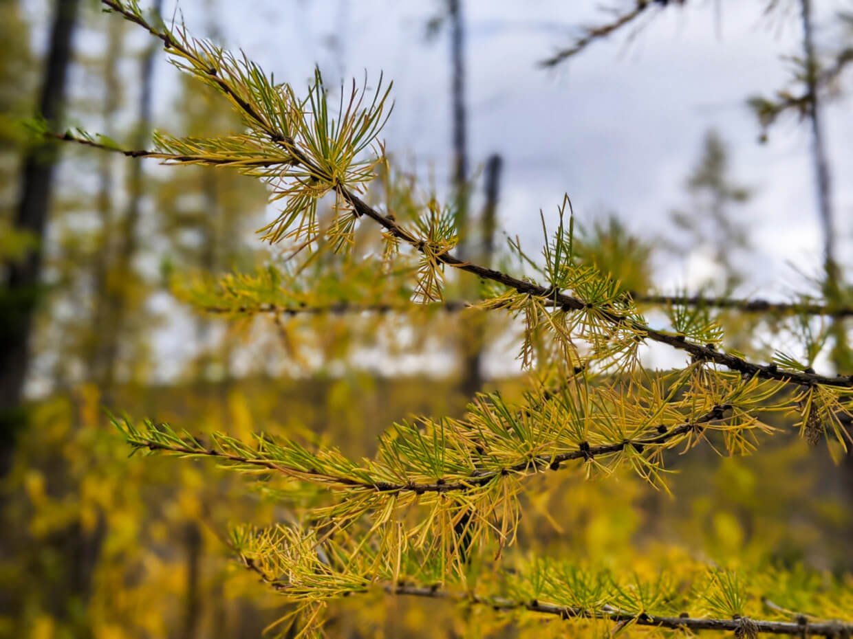
Autumn is a particularly special season to walk or cycle the Myra Canyon trestles. The pops of autumn colours on the hillsides around the trail seemed to fit perfectly with the rustic Myra Canyon trestles.
Myra Canyon is also one of the most easily accessible locations in the Okanagan Valley to see western larch trees, which turn golden in autumn.

One of the only coniferous, deciduous trees, larches have cones like evergreens but drop their needles every autumn. Before doing so, the needles turn a gorgeous golden yellow colour for a short time.
The western larch, or Larix Occidentalis, is a taller version of the alpine larch. It prefers to live at lower elevations. The average Western larch is 500 to 1,000 years old.
The best time for viewing the larches is usually mid October to late October, but it does vary depending on the year.
Read Next: Where to Find Golden Larches in British Columbia
Myra Canyon Trestle trailheads
Myra Station and Ruth Station are located 12km apart. Both Myra Canyon Trestle trailheads are marked on Google Maps, my recommendation for driving navigation.
- Myra Station (click for directions) is an easy 40-minute drive from Kelowna. Follow the KLO Road east and then turn onto McCulloch Road (side note, McCulloch was the KVR’s chief engineer). Continue along McCulloch until the Myra Forest Service Road turnoff
This 8km long gravel (unpaved) forest service road will take you all the way to the Myra Station parking lot. It is a reasonably well-maintained gravel road, usually drivable with a 2WD.
- Ruth Station (sometimes called June Springs, click for directions) is a slightly longer drive from Kelowna. Follow the above instructions but turn off earlier on June Springs Rd before reaching Gallagher’s Canyon Golf Resort
June Springs eventually turns into Little White Forest Service Road, a gravel forest service road. This 4km long road goes to the main Ruth Station parking lot.
If you like, you can continue another 1.5km along the KVR itself (motorised vehicles are allowed on this section) to a smaller parking lot. Expect to see some potholes on this section.

Hiking the Myra Canyon trestles
If you’re planning to hike the Myra Canyon trestles, I’d recommend heading to the Myra Station trailhead.
There’s a better concentration of trestles close to the trailhead and I think the views are better too.
The first trestle (number 18) is 1km from the Myra Station parking lot. Another kilometre traverses five more. If you turn round at the 2km marker, the hike will take around one hour.

The most popular Myra Canyon hike is a 8km return trip (4km each way) from the Myra Station parking lot. This takes in 13 bridges (of 18) and 2 tunnels. For most people, this will take around two hours.
If you can, I’d recommend going a little further (10km return). The views from Trestle 7 are particularly excellent and are definitely worth the extra distance in my opinion! The trail also passes next to a larch forest in this section. We recently hiked this route and spent three hours total, with lots of photo stops.

Biking the Myra Canyon trestles
Myra Canyon is very popular with cyclists, particularly young families. The 24km return trip between Myra Station and Ruth Station takes in all 18 trestles plus two tunnels. Most people take around 2-3 hours to complete the full 24km journey.
The route is almost completely flat the whole way but there is a slight downhill grade from Myra Station to Ruth Station. For this reason, some people like to start at Ruth Station for a more cruisey return journey.

Myra Canyon bike rentals and tours
If you don’t have a bike, there are bike rentals available right at Myra Station from May to October.
For a longer adventure, it’s possible to cycle all the way to Penticton (around 70km) and then get a shuttle back to Kelowna. Myra Canyon Bike Tours offers this in combination with a wine tour of the Naramata Bench.
Alternatively, you can also get a shuttle from Penticton to Myra Canyon and then cycle back at leisure.
When cycling the KVR, keep in mind that bikes must yield to hikers on trestle bridges.

Essential info
- Myra Canyon is open all year round, though occasionally closes for trestle and trail maintenance
- It is completely free to park at either Ruth or Myra Station and there is also no fee to hike the Myra Canyon trestles
- There are two outhouses at the Myra Station parking lot and one near the beginning of the trail at Ruth Station
- Another outhouse is located at the 4km mark (8km from Ruth Station). I’d recommend bringing your own toilet paper, just in case
- Myra Canyon is located at around 1200m elevation. This means that Myra Canyon can feel a lot cooler than elsewhere in Okanagan Valley
- Bring extra layers and be prepared for changeable weather during the shoulder seasons. Expect snow from October to April
- Dogs are allowed on the trail but must be on leash at all times
- There are many benches – 14 in total – situated along the 12km trail
- Trestle 18 (the closest to Myra Station) has a detour path suitable for anyone who may be uncomfortable with walking on the bridge itself
- Keep to the trail to stay safe (there are some steep drop-offs!) and help protect plant life
- Phone signal is intermittent in Myra Canyon

Looking to book a stay in Kelowna?
The Royal Kelowna – Upscale suites and apartments just a few minutes walk from Okanagan Lake
Hotel Zed – Colourful and quirky motel in the heart of downtown, only steps from the beach
Myra Canyon Ranch – Beautiful, highly rated property located very close to the Ruth Station trailhead


Planning an Okanagan Valley trip? I think you’ll like these related posts:
8 Fast and Fun Hikes in Vernon, British Columbia
Okanagan Valley Road Trip, BC: What to Do and Where to Stop
34 Awesome Things to Do in Vernon, British Columbia
Rattlesnake Island, British Columbia: Small Island, Dramatic History
A Local’s Guide to the Best Okanagan Valley Wineries, British Columbia
74 Things To Do In Penticton and the Southern Okanagan, British Columbia
Check out these other hiking posts next

One half of the Canadian/British couple behind Off Track Travel, Gemma is happiest when hiking on the trail or planning the next big travel adventure. JR and Gemma are currently based in the beautiful Okanagan Valley, British Columbia, Canada. Consider buying us a coffee if you have find any of our guides helpful!
I was delighted to find this site and its wealth of information regarding the Myra Canyon Trestles. I live in Australia, but spent a year (1997-1998) on a teaching exchage in Kelowna. I walked the trestles in August 1998 and was horrified to learn of their destruction by the 2003 fires. I was subsequently delighted to hear of their restoration and give my congratulations to the Myra Canyon Restoration Society.
I took a number of photos of the flora and fauna along the walkway over the trestles on 4th August 1997 and have just posted them to the iNaturalist website: https://www.inaturalist.org/observations?on=1997-08-04&place_id=any&subview=table&user_id=kenharris&verifiable=any
I have a number of photos of some of the trestles and some of the views, but at that time they were taken on colour slides and I have only scanned the natural history pictures.
If you have any interest in these early pictures I could pronanly get them scanned and then sen them to you.
With best wishes,
Ken Harris
Hi Ken,
Great to hear from you. I’m slightly envious that you were able to walk the original trestles! I would definitely be interested in seeing your photo – my email address is gemma[at]offtracktravel.ca, if you have the time.
Hi there, is the canyon open now ?
Yes, it is 🙂
do you have to pay for a tour if your on bikes, or can you just bike the trail for free if you don’t want the tour?
Thanks
Hi Lindsy,
If you have your own bikes, it’s free to cycle Myra Canyon.
How long are the two tunnels on the trail ?
Hi John,
The first tunnel is 114m and the second 84m.
Hi, would it be possible to drive an RV to Myra Station?
Hi Esmee,
I’ve heard of people doing it. Caution is needed since the road is not paved (gravel). I think it would depend on your level of comfort driving on unpaved roads and whether the RV is yours or a rental (most rental companies do not allow their vehicles to be driven on unpaved roads).
@Esmee, Absolutely, been there many times and always see large RVs up there. The road is dusty (in summer) but decent. Plenty of room up there to turn around.