The Glacier Crest Trail is a tough yet gratifying hike in British Columbia’s awe-inspiring Glacier National Park.
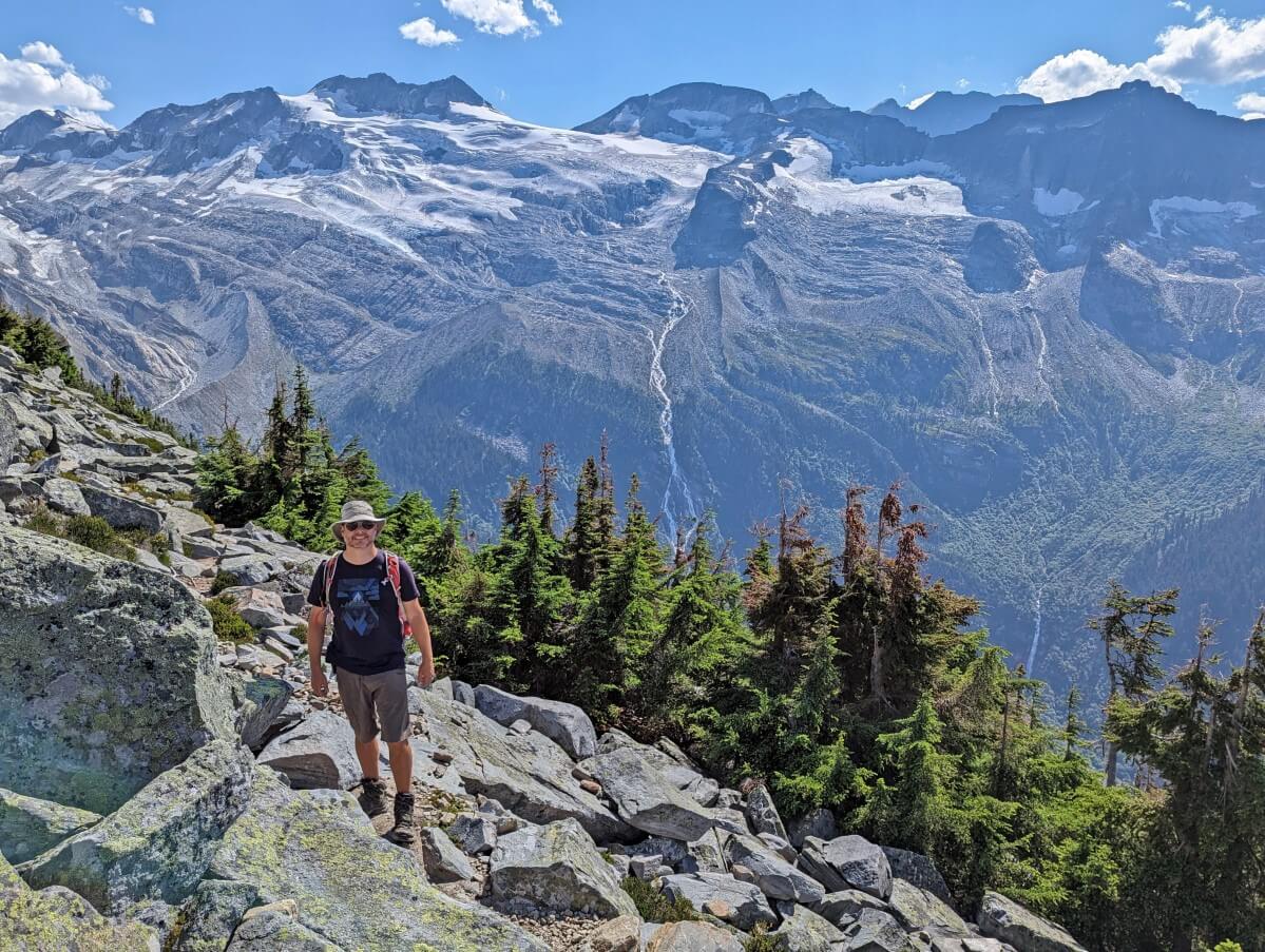
The destination of this challenging trail is the top of a naturally carved ridge, with the Illecillewaet Glacier on one side and the Asulkan Glacier on the other. Tall waterfalls cascade from these glaciers into the forested valleys below.

Mountain peaks crowd the views to the north, with Mount Sir Donald, the tallest summit along the Trans Canada Highway (3,284m) looming over it all. Needless to say, the views are nothing short of extraordinary.

Highway 1 provides incredibly convenient access to this impressive trail, with the trailhead just 1km from the traffic.
With such great natural beauty and easy accessibility, you may imagine that the Glacier Crest Trail is a busy hiking experience. Not so. We encountered less than a dozen hikers on a Sunday at the end of July, during peak hiking season.
For all these reasons and more, I would recommend the Glacier Crest Trail as a worthy addition to any experienced hiker’s to-do list. This detailed post will help you plan a future hike with a trail overview, safety tips and more.
What to expect:
Glacier Crest Trail
Location: Glacier National Park, British Columbia
Distance: 11.4km return
Elevation gain: 960m elevation gain
Hike type: Out and back
Time: 6 to 7 hours
Difficulty: Challenging
Camping: Frontcountry campground near trailhead
Fees: National park pass ($12.25/adult)
When to go: Late July to September
Dogs: Allowed on leash
Backcountry necessities
- Always bring the 10 Essentials
- Know how to stay safe in the backcountry
- Remember to Leave No Trace to help keep the wilderness wild
- Understand how to avoid negative bear encounters
- Trying out backpacking for the first time? Read Backpacking 101
- Check out our packing guide with gear recommendations
- Sign up to our newsletter for a free backpacking checklist
Glacier Crest Trail, Glacier National Park
The Glacier Crest Trail is a challenging hiking path in the Selkirk mountains of Glacier National Park, British Columbia.
The eponymous ‘crest’ (and final destination of the hike) is the naturally carved ridge between the Asulkan and Illecillewaet glaciers.

The latter is the source of the Illecillewaet River. Pronounced ‘ill-ah-SIL-ah-wet,’ Illecillewaet is a Sinixt word meaning ‘big water.’
As well as the Sinixt, Glacier National Park is the traditional territory of the Ktunaxa, Secwépemc and Syilx people.

The Glacier Crest Trail is part of a tourist trail system created more than 100 years ago.
The Canadian Pacific Railway was constructed through Rogers Pass in the 1880s, with the original Glacier station located next to the Illecillewaet River.
Shortly thereafter, Glacier House was built as a dining lodge to cater to railway passengers. It was later developed into a hotel and CPR employed guides from Switzerland to build hiking trails and tour visitors around the surrounding mountains.

With that timeline in mind, it is interesting to note that Glacier House predated the original (and much more famous) Lake Louise Chalet.
Over time, Glacier House was expanded to 90 rooms hosting 150 people and facilities included a bowling alley, billiard hall, lawns and gardens. The railway was rerouted in 1916 and the hotel closed to guests in September 1925.
Today, over half a million people visit Glacier National Park each year by road. Another popular hike is the Hermit Trail.
Quick Glacier Crest Trail facts:
- 11.4km return distance with 960m elevation gain
- Usually snow-free from late July to late September, longer season dependent on weather and snowfall
- Parks Canada National Park pass required, no reservation or specific trail pass needed
- Glacier National Park is on Pacific Time – 1 hour behind Mountain Time
- Dogs are allowed on leash but please keep in mind the high level of bear activity in the area as well as the lack of water sources and steep incline

Glacier Crest Trail hiking experience
Know what to expect on the Glacier Crest hike with this trail overview.
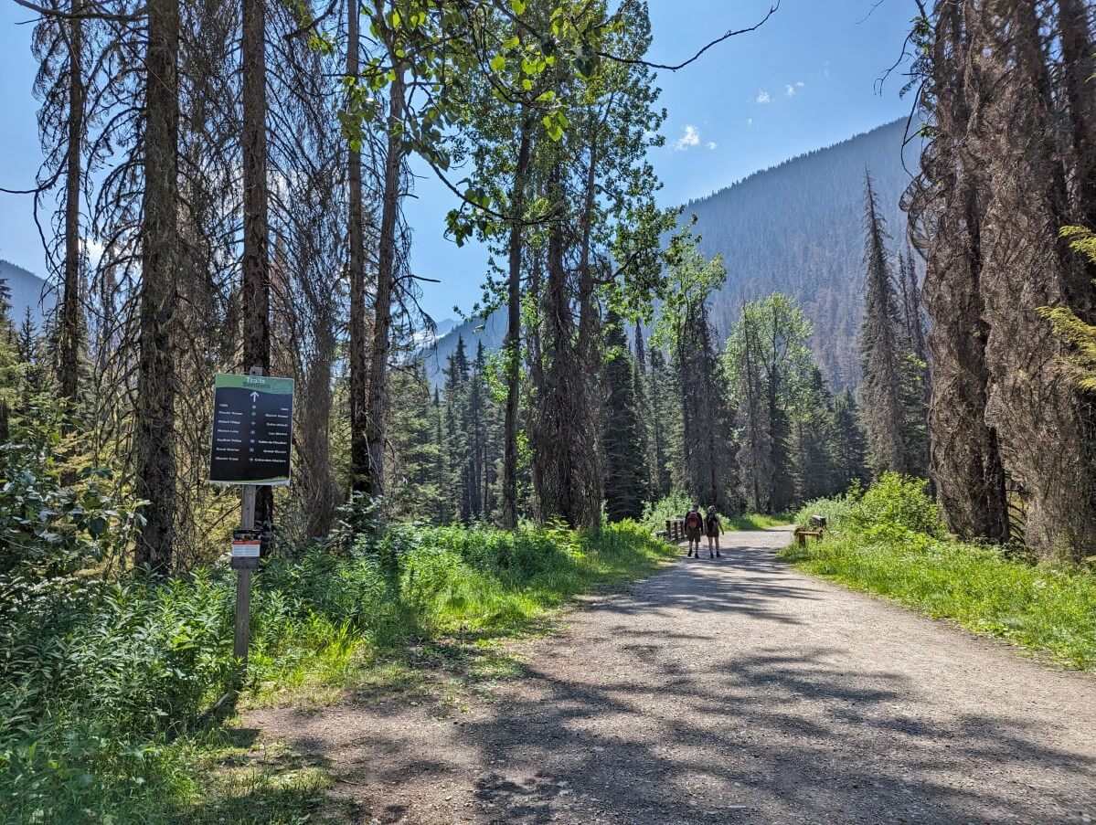
Trailhead to Asulkan Valley junction
The Glacier Crest Trail eases hikers in gently with a long section of mostly flat, level trail on the old railway grade.
Illecillewaet Campground trailhead is the starting point for half a dozen different trails. Look for the Glacier Crest Trail / Asulkan Valley Trail signs at the first junction.
After a bridge crossing, the trail arrives at the ruins of Glacier House. Stone foundations are the only indicator of this once-impressive facility.
The gardens have been taken over by wildflower-scattered meadows and squeaking ground squirrels.

Check out the interpretive signage and then head into the lush Asulkan Valley on a 100+ year-old trail. The path has a slow incline as it roughly parallels Asulkan Brook.
After crossing a large bridge, keep your eyes peeled for Glacier Crest Trail signage on the left-hand side.
As soon as you turn, it’s all up from here. This is where the real hike starts (1.7km from the trailhead)!

Asulkan Valley junction to treeline
The ascent begins with a series of forested switchbacks. Some are steeper than others. Rocks pepper the dirt, so be careful not to trip.

As the trail winds up along the side of the mountain, the path becomes narrower and the drop-off more sheer.
Views of surrounding peaks and the highway below start to appear through the thinning trees.

After a couple of long switchbacks, the trail becomes a lot rockier and steeper. You’ll need to step up and down some of the larger rocks.
The switchbacks continue but are shorter and steeper.
The vistas are starting to get really good at this point but there’s still work to be done. Keep going!

Treeline to ridge
Up and out of the forest, the trail becomes much wider.
A scattering of trees gradually dispenses, revealing a ridge to the left. There is very little shade from this point on.

Continue climbing and finally (finally!) the Asulkan Glacier appears on the right.
With large boulders bordering the trail to the left, this is a good place to stop for a snack to take in the views. It’s not far to the end but you may want an extra boost.

The trail is rocky here and though you can now see ahead, it can sometimes be difficult to see the correct route. Look for the beaten rocks and dirt.

At the 5.2km mark, the trail turns east (left) and heads up to the top of the ridge.
The first part of the route is a mix of rock and loose dirt and is very steep. In 2025, I believe Parks Canada staff added rock steps to this section.
This very steep climb lasts around 250m. The gradient mellows out a little after that.

The top of the ridge is a jumble of rocks, but most are solid. There is a well-used route along the crest to a trail sign. Beyond that, there is a summit cairn. This is the end of the official trail.

Ridge to the parking area
The return journey is via the same route, though I would recommend the following short detour (200m extra).

660m from the end, take a right-hand turn on the Meeting of the Waters loop. A short stretch downhill leads to the confluence of the Asulkan Brook and Illecillewaet River. Sink into one of the Parks Canada red chairs and take a break!
When ready, cross the bridge and take the next left. This will return you to the Illecillewaet Campground trailhead.
The final approach offers a view of the underside of the impressive stone bridge leading to the Glacier House ruins.
Back at the parking area, you can pack yourself on the back for completing such a challenging but rewarding hike!

Glacier Crest Trail hiking guide
Inspired to hike the Glacier Crest Trail? In this section, you’ll discover everything you need to know to start planning a trip.
There are affiliate links in the text ahead. If you make a purchase via one of these links, we may receive a small percentage of the sale.
Location
The Glacier Crest Trail is situated in Glacier National Park in British Columbia, Canada. Please note that there is a national park in the USA with the same name!
Glacier National Park surrounds a long stretch of the Trans Canada Highway (1) between the towns of Revelstoke and Golden.
The Glacier Crest trailhead is 65km from Revelstoke and 90km from Golden.

Trailhead and parking
The Glacier Crest trailhead is located at the end of the Illecillewaet Campground road, 1km from Highway 1.
The Illecillewaet Campground road is only accessible from Highway 1 when driving eastbound.
When driving westbound (from Golden, Banff), you must pass the turnoff and continue another 1.5km to a marked U-turn route.
If you miss that, don’t panic. Continue another 1.3km and there is another opportunity to turn around at the turnoff to the Loop Brook Campground.
The Illecillewaet Campground road is 1km long and features two trailheads.
The first is the Illecillewaet Valley trailhead, which is located on the right-hand side almost immediately after the turn from Highway 1.
There is perpendicular parking for around ten vehicles. I would only park here if there is no other space further up the road. Add 2km return to trail distances if that is the case.

The Illecillewaet Campground trailhead is right at the end of the road. There are around 35-40 perpendicular parking spots on the right-hand side and many more parallel parking opportunities.
Glacier Crest isn’t the only trail starting at this location. On busy days (weekends, holidays), vehicles sometimes line the road almost back to the highway. Be sure to follow ‘no parking’ signs and keep clear of junctions.
I have seen larger RVs parked along this road, though be warned that there is less and less turnaround space as you continue along the road.
The Illecillewaet Campground trailhead features a Welcome Center kiosk (staffed in the summer months), outhouses, food lockers and signage.

When is the best time to hike the Glacier Crest Trail?
The Glacier Crest Trail is usually snow-free from late July to late September.
The path may be snow-free for a longer period but conditions vary from year to year. In 2023, the trail was snow-free in late June due to higher-than-average temperatures.
Before heading out to hike, be sure to check the latest trail conditions on the Glacier National Park website.
Due to recent bear activity, Parks Canada will sometimes restrict group size on hiking trails in this area to groups of 4 or more. When such a restriction is in place, you cannot hike the Glacier Crest Trail unless you are hiking in a close group of 4 or more.

How difficult is the Glacier Crest Trail?
I would rate the Glacier Crest Trail to be challenging. This is mainly due to the steepness of the trail.
The technical level of the path is moderate. It is a hiking trail (not a route), with a mix of well-established dirt sections as well as more rugged, rockier sections. No scrambling or technical skills are required.

The real challenge of this trail is how steep it is. Like the majority of Glacier National Parks’ hiking trails, the majority of the Glacier Crest Trail is steep or very steep.
While the trail is 5.7km long (11.4km total), most of the 960m elevation gain is climbed within a short 3.7km distance. The incline is around 25-30%.
To offer some perspective, I’d usually refer to a 10%-15% incline as a steady ascent. The Glacier Crest Trail is unrelentingly steep.
If you are fit and used to hiking steep mountain paths, the Glacier Crest Trail should not provide any major challenges.

For most people, however, ascending this trail will be a cardio workout. Drink plenty of water, take your time and expect your legs to be sore the next day.
If you’re new to hiking, I would recommend building up to this trail. Choose some similar-length trails with less elevation first.
A good example would be the Stanley Glacier Trail in Kootenay National Park (8.2km return with 370m elevation gain) or the Eva Lake Trail in nearby Mount Revelstoke National Park (14km return with 270m elevation gain).

How long does it take to hike the Glacier Crest Trail?
The average time to hike the Glacier Crest Trail is 6 to 7 hours.
Fast hikers may finish closer to 5 hours. Slow and steady hikers should allow 7 to 8 hours.
We spent 7 hours on the trail, with an extended lunch break (40 minutes) at the summit. We also paused for 20 minutes close to the top.
Whatever your hiking speed, plan for a full-day hike. Bring food, snacks, plenty of water and the other 10 Essentials.

Glacier Crest Trail navigation
The Glacier Crest Trail is an established hiking trail, with clear brown national park signage at all junctions.
The start of the trail is at the end of the Illecillewaet Campground road. There are half a dozen other hiking trails also starting here, so be sure to read the signage carefully.
The first part of the Glacier Crest Trail is part of the Meeting of the Waters Trail and later the Asulkan Valley Trail.
The easiest place to go wrong would be to miss the final left-hand turn onto the Glacier Crest Trail proper from the Asulkan Valley Trail. This is 1.7km from the trailhead.
There is a sign (see below photo) but I can see how it could be overlooked.

As the trail ascends, the path becomes rockier and rockier. It also becomes wider in places. Above the trees, it can become a little more difficult to navigate. Look for the beaten route across the rocks.
The final ascent up to the ridge can be tricky to follow. There are several alternative routes parallel to the main one. Pick your way carefully and watch your footing.
Patches of snow during the early season (July) can make navigation here more difficult. We did spot some small cairns along this section, but I wouldn’t rely on them.

Glacier Crest Trail fees and permits
While there is no specific fee to hike the Glacier Crest Trail itself, there is a requirement to have a valid Park Pass for Glacier National Park.
In 2026, park pass fees for Glacier National Park are $12.25/day per adult or $10.75/day for seniors. Youth and children are free.
Park passes for the national parks in and around the Canadian Rockies are interchangeable.
If you have a Park Pass for Banff National Park (or Jasper, Yoho, Waterton, Kootenay or Mount Revelstoke), it is also valid in Glacier National Park.
Park passes can be purchased at the Rogers Pass Discovery Centre and Welcome Center by the Illecillewaet Campground.
Hiking other trails in the national parks in and around the Rockies? It may be better value to buy a Discovery Pass (an annual pass). In 2026, Discovery Passes are $83.50/adult OR $167.50 for a group (up to 7 adults).
No fees will be charged for access to Glacier National Park from 19th June to 7th September 2026 as part of the Canada Strong program.

Wildlife in Glacier National Park
Glacier National Park is home to a variety of mammals (including black bears, grizzly bears and mountain goats) as well as many species of birds.
Grizzly bears roam the Asulkan Valley where the Glacier Crest Trail is located. Bear warnings (like this one) are usually posted each summer.
Some years, Glacier National Park restricts access to the higher Illecillewaet/Asulkan trails to groups of four or more adults due to recent bear activity. Be sure to check the Glacier National Park bulletin page before visiting.
Parks Canada often operates an information kiosk close to the Glacier House ruins (Meeting of the Waters Trail).
A wildlife observation board records recent wildlife sightings. Alternatively, you can chat with staff at the Welcome Center near the Illecillewaet Campground.

Negative wildlife encounters are rare on the Glacier Crest Trail (and across the Glacier National Park more generally). Parks Canada promotes coexistence and there are a few things hikers can do to help:
- Make noise while hiking. This alerts wildlife to your presence and gives them a chance to avoid you. As a general rule, animals don’t want to be close to humans
- Leave No Trace. After eating, make sure you haven’t left any food or wrappers at your location (read more Leave No Trace tips)
- Give wildlife space. If you do see any animals, keep your distance – ideally 100m or more. This offers them an escape route
- Know what to do if a bear approaches you. Always remain calm. Depending on the behaviour of the bear, different techniques are required (read our bear safety post for more info)
- Bring bear spray and store it in an accessible place. An aerosol deterrent made with chilli pepper oil, bear spray is a ‘last resort’ tool intended to be used only when other methods have failed

Glacier Crest Trail safety information
While located close to Highway 1, the Glacier Crest Trail is still surrounded by relatively remote mountainous terrain. Keep the following in mind when planning a trip:
- Phone signal is limited on the trail. We had decent Rogers phone signal in the campground, at the trailhead and intermittently during the hike but still brought our InReach device in case of emergencies
- Tell someone where you’re going and when you plan to be back (check out our outdoor safety guide for more tips)
- Weather conditions can vary and change quickly. Bring extra clothing in case of cold or wet weather
- There may be snow patches on the main trail until late July. Snow is possible at any time of the year
- There are no water sources along the majority of the route. The last river access is at 1.6km. Bring at least 2l of water per person, ideally more
- The Glacier Crest Trail has limited shade. Bring sun protection and extra water in warm weather. Start early (pre-9am) if you can
- Most of this trail is consistently steep with significant elevation gain. Most people will find this physically difficult
- The final ascent to the ridge features very steep terrain with loose rock. This short section requires particularly careful footwork
- Besides these hazards, it’s also important to be aware of wildlife, particularly grizzly bears (see previous section)

Glacier Crest Trail packing list
Be sure to wear a pair of tried and tested hiking shoes/boots and bring the 10 Essentials in your daypack (we use the Osprey Talon 22):
- Extra clothing for the coldest possible conditions during the season you are travelling in
- Sun protection to prevent sunburn and sunstroke (sunscreen, sunglasses, lip balm, sunhat)
- Food, including lunch and snacks
- Water, at least 2.5l per person during warm weather
- First Aid supplies in case of injury or sudden illness
- Fire starters, carry matches at a minimum
- Personal light to illuminate your route if delayed (such as a headlamp)
- Repair kit and tools, such as a knife and a small amount of duct tape
- Emergency shelter, carry an emergency blanket at a minimum
- Signalling device such as a whistle. There is limited cell phone signal in this area. If you have a satellite device, bring it
- Map, an overview plus app navigation (AllTrails, Organic Maps, Gaia, CalTopo)
I would also suggest bringing bear spray, in an easily accessible holster. Those sensitive to mosquitoes may want to bring repellent during early summer.
Hiking poles are useful to have on this hike, especially for the steep descent. JR and I usually share a pair of Black Diamond Carbon Z poles, which are incredibly light and fold down into three sections for easy storage when not in use

Where to stay before or after hiking the Glacier Crest Trail
If you can, I’d suggest spending at least one night in Glacier National Park. Camping is the only option, however, so scroll to the next section if you don’t like to sleep on the ground!
The most convenient place to stay is Illecillewaet Campground, located right at the trailhead. Set into a narrow valley, this frontcountry campground is on the compact side and has 60 spots for tents and smaller RVs (less than 10m / 33 foot). Sites are $26.75/night.
As of 2026, half of the campsites in this campground are reservable. Reservations open in January each year, with the date posted on the Parks Canada website in December.
For the first come, first serve sites, visit the Welcome Center for registration. Plan to arrive early in the day to secure a site, especially on weekends. Check-out time is 12pm. At this time, existing campers need to extend their stay or leave.
There are flush toilets, campfires, kitchen shelters, potable water and food lockers in the Illecillewaet campground but no showers.

Loop Brook Campground is Glacier National Park’s other frontcountry campground. It is 1km from the Glacier Crest trailhead (walkable via a dedicated trail).
While campsites at Loop Brook are reservable, there are only 20 total. Loop Brook has similar facilities to Illecillewaet Campground. Again, the sites are on the smaller side and there are no showers. The nightly fee is $23.
Other local accommodation options
One of the closest non-camping options is Heather Mountain Lodge. This beautiful property is located just beyond Glacier National Park’s eastern border.
Choose between comfortable lodge rooms and cabins. Room packages with guiding services are available.
Almost the same distance in the other direction is Canyon Hot Springs Resort. As well as the two large mineral pools, there is a full-service RV park and tent campground plus rustic cabins and lodges.
Revelstoke is the closest full-service town to the Glacier Crest Trail (65km). There is a good choice of accommodation here, from hotels and motels to B&Bs and vacation rentals. There are also many fun things to do in Revelstoke.
My top pick for accommodation in Revelstoke is the Regent Hotel on 1st Street. This stylish family-owned and operated hotel (one of the oldest in Canada!) is incredibly central to everything in downtown Revelstoke. Breakfast is included and features the best hotel buffet I’ve had anywhere in British Columbia.

Other hiking posts you may enjoy:
The Floe Lake Trail: Complete Hiking Guide
17+ of the Best Day Hikes in British Columbia, Canada
The Great Divide Trail: Canada’s Most Epic Thru Hike
Where to Find Golden Larches in British Columbia, Canada
16 of the Best South Okanagan Hiking Trails


One half of the Canadian/British couple behind Off Track Travel, Gemma is happiest when hiking on the trail or planning the next big travel adventure. JR and Gemma are currently based in the beautiful Okanagan Valley, British Columbia, Canada. Consider buying us a coffee if you have find any of our guides helpful!