Just a short drive south of Penticton, the Peach Cliff hike is short, rewarding and surprisingly interesting. The panoramic views span Vaseux Lake and McIntyre Bluff, stretch across Okanagan Falls and Skaha Lake, and reach all the way to Penticton.
As locals, this is one of our favourite trails for an early morning summer hike. There’s something especially rewarding about getting out on the trail before the temperatures climb, then spending the afternoon enjoying a few local wineries and a swim in the lake.

The Peach Cliff Trail also ideal for those slightly chilly spring or autumn days when you’re feeling a bit lazy but it’s just way too sunny to stay inside. For hikers wanting to spend more time on the trail, several longer routes are available.
This post tells you everything you need to know about the Peach Cliff hike, including where to find the trailhead in Okanagan Falls, how to see the best views and the side trails you can’t miss!
Peach Cliff
Location: Okanagan Falls, British Columbia
Distance: 4km return (shortest route)
Elevation gain: 180m elevation gain
Hike type: Out and back
Time: 1.5 to 2 hours
Difficulty: Moderate, due to steep climb
Camping: No
Fees: None
When to go: All year round
Dogs: Permitted on leash
There are some affiliate links in this post. If you click through and make a purchase, we may receive a small percentage of the sale at no extra cost to you.

Backcountry necessities
- Always bring the 10 Essentials
- Know how to stay safe in the backcountry
- Remember to Leave No Trace to help keep the wilderness wild
- Understand how to avoid negative bear encounters

Introducing Peach Cliff
When driving through the Okanagan Valley there are a number of towering cliffs and bluffs that catch the eye. One of these is Peach Cliff, a rocky outcrop that looks over the small town of Okanagan Falls (OK Falls for short).
This 600m rockface is part of what was once the continental shelf and is approximately two billion years old. The outcrop was originally created by earthquakes and volcanoes but then rounded out by glaciers and ice melt.

A telecommunications tower now sits atop Peach Cliff, making the summit easy to spot when visiting Okanagan Falls.
The rock face is approached from behind, along a network of trails that can feel a little maze-like. As a result, the views only open up near the end of the hike, making them feel like a well-earned reward.

From 1969 to 1976, the Peach Cliff hiking area was home to the Dusty Mac Mine which produced silver and gold. Artefacts from the mining era can be seen along the Peach Cliff Trail. The Nature Trust now protects this land.
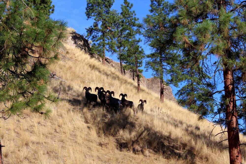
Bighorn sheep relatively common in this area, and we’ve seen them on a few occasions both on the trail and en route to the trailhead. Always keep your distance and allow them plenty of space, as they can be easily startled.

Peach Cliff trailhead
The Peach Cliff trailhead sits on McLean Creek Road, a quiet backroad east of Okanagan Falls. There is a gate (see photo below) just to the right of the property at 4062 McLean Creek Road.
There is no designated parking area, but vehicles can safely park parallel to the road. As always, be respectful of local residents and obey any posted ‘no parking’ signs.

McLean Creek Road is very popular with cyclists so be careful when pulling back onto the road on your way out.
Like a lot of other trails in this area of the Okanagan, there is zero trail signage at the trailhead or along the hike. For that reason, I would highly recommend following a GPX route or the AllTrails track.
Peach Cliff hike experience
From the trailhead, walk through the gate and continue ahead along the well established path up and over a small hill.
After about ten minutes of hiking, the trail opens up and what looks like a tower of wood pallets appears on the left.

This structure stores old core mining samples. Most have now been removed but some are still visible around the back.
Stay left after the mining remains. Just around the corner is the turn-off for an old quarry pit (look for several large rocks marking the detour). The now filled-in quarry pit sits 100m from the main route and now glitters green on sunny days and is filled with goldfish.

Quarry pit turn-off to Peach Cliff summit
Back on the main trail, things get a bit confusing from here. To find the route to the top of Peach Cliff, you really need to know where you’re going – it’s a confusing network of different trails, big and small.
Our favoured route travels northwest, along a trail that detour into the forest from the ‘main route.’ It follows a fence for a short time before heading up a small slope. It then continues to climb slowly for another 400m.

Then, there is a key junction. The widest, most established path continues ahead – for Peach Cliff, take a sharp left instead on a narrower trail. This leads to a gate, which has a chain catch (top tip – open it towards you).
The trail carries on for a short distance before curving and starting to climb. It begins gently but soon steepens, leading into about 100 metres of switchbacks over loose rock with roughly 40 metres of elevation gain (40% grade!)

The path then levels and there is a clearing where you can rest. The views from here across Skaha Lake and Okanagan Falls are fantastic.
For even better panoramas, continue up to the summit. There are another couple of small switchbacks to ascend, but these are not nearly as steep. At the top, enjoy incredible views of Vaseux Lake and McIntyre Bluff.

Essential details and tips
- The most direct Peach Cliff hike is 4km with 180m total elevation gain. Allow 1.5 to 2 hours, with a stop at the top
- For a longer hike, check out this Peach Cliff Loop route on AllTrails – it’s 6.3km total
- Like most other hikes in the South Okanagan, there is very little shade so be sure to head out early when hiking in summer (before 9am!), bring a hat, sunscreen, plenty of water etc.
- As well as bighorn sheep, look out for rattlesnakes and other snakes. Watch your step, as they like to sunbathe on the path
- Ticks are out and about in the spring, though possible throughout the summer too. Stay on the trail and do a tick check after hiking
- While hiking, enjoy the scent of pine as you pass below the beautiful ponderosa pine trees. It’s more noticeable on hot dry days. A classic and natural Okanagan fragrance!

- If planning to hike to the top of Peach Cliff, be sure to wear shoes with decent tread – there is a lot of loose rock and it is easy to slip
- I would highly recommend bringing poles to go down the very steep section close to the summit if you don’t have great balance or are fearful of heights. Our poles of choice are the Black Diamond Carbon Z – super light and foldable for easy transport
- Concerned about the steep section? It is genuinely very steep but is very short too. I timed myself on our last hike and it took me six minutes to finish that 100m section and I was not moving that fast (I’m not great with loose rock while going downhill)
- I cannot stress enough that first timers will struggle to find the route to Peach Cliff without a map/GPX track/direction from AllTrails. There is no signage at all and many side trails
Other local hiking guides you may find helpful
18 Fast and Fun Hikes in Penticton
Giant’s Head Mountain, Summerland
17 of the Best South Okanagan Hiking Trails
17+ of the Best Day Hikes in British Columbia, Canada
Check out these recently published posts:


One half of the Canadian/British couple behind Off Track Travel, Gemma is happiest when hiking on the trail or planning the next big travel adventure. JR and Gemma are currently based in the beautiful Okanagan Valley, British Columbia, Canada. Consider buying us a coffee if you have find any of our guides helpful!
Looks amazing, love the bits of history and all the views from the hike! Definitely would love to do it!
Thanks Audrey, it’s an interesting (and beautiful) hike for sure!
We tried this hike yesterday when it was really hot. Not a good idea as there’s not much shade. The trail is not well marked at all. After the pool we were lost. A local woman came by and steered us in the right direction but also warned us of the many rattlesnakes in the area. Being so hot we weren’t wearing long pants and a couple of us only running shoes so we turned back.
Would not recommend this hike
Hi Shari,
It’s too bad you didn’t like this hike! Like most trails in the Okanagan, it is not marked, something I mentioned in the post. There also isn’t a lot of shade and rattlesnakes (and other wildlife) are always a possibility, as they are almost anywhere in the southern Okanagan Valley. Luckily though, the rattlesnakes here are not aggressive and you just have to watch your step, especially in rocky areas.
For this and most other trails in the area, it is best to hike early (starting before 9am) in the summer or go in spring/autumn.