Giant’s Head Mountain is the ideal destination for a quick hike in the South Okanagan region of British Columbia, Canada.
Not only super easy to access, there’s a range of interconnecting hiking trails so you can ‘choose your own adventure’ to reach the summit!
Hiking at Giant’s Head offers the chance to see expansive views of the local area as well as Naramata, Penticton and the mountains beyond, no matter what time of day or season you visit.
Read on for our experience plus all the details you need to hike Giant’s Head Mountain in Summerland yourself.
This post includes affiliate links. If you make a qualifying purchase through one of these links, I may receive a small percentage at no extra cost to you.

Backcountry necessities
- Always bring the 10 Essentials
- Know how to stay safe in the backcountry
- Remember to Leave No Trace to help keep the wilderness wild
- Understand how to avoid negative bear encounters

About Giant’s Head Mountain
Giant’s Head is undoubtedly one of the most distinctive peaks in the South Okanagan region.
When approaching from the southeast, this 850m extinct volcano does indeed look like the profile of a very large man looming over the nearby town of Summerland.
One of my favourite aspects of Giant’s Head is that you don’t have to be a keen hiker to summit it. There is a narrow paved road leading almost all the way to the top of Giant’s Head, open from late spring to early autumn.

The road lessens the natural feel but it makes Giant’s Head a very inclusive destination for family groups.
Those wanting a longer hike can start from the base parking lot (550m elevation) and walk on the road or follow one of the many trails to the summit instead.
Giant’s Head Mountain trails
Hikers have a choice of four routes to ascend Giant’s Head Mountain (one-way distances):
- Roadway (paved) – 2.6km, 240m elevation gain, moderate rating
- The Grind Trail – 1.9km, 275m elevation gain, difficult rating
- East Ridge Trail – 3km, 335m elevation gain, difficult rating
- Friendly Giant Trail – 1.6km*, 135m elevation gain, moderate rating
The ratings given above are those noted on the official signage in the parking lot. In my personal experience, I find these ratings on the cautious side.

*Please note that the Roadway and Friendly Giant Trail do not lead all the way to the summit – there’s another 500m and 50m elevation gain needed to reach the top. The Friendly Giant Trail is only accessible 1.4km along the paved Roadway.
There’s an additional trail from the two parking lots near the top of Giant’s Head:
- Upper Loop – 0.9km, 15m elevation gain, easy

Climbing Giant’s Head Mountain
From the parking lot, follow the paved Roadway. The other trails splinter off gradually – look for the colourful signage and occasional trail maps.
Being that the main parking lot is already at around 550m, spectacular views over Summerland and the lake appear pretty quickly.
Connection trails make it possible to hike one trail and then switch to another later. This interconnected trail system offers so many different hiking possibilities!
On our most recent hike, we stayed on the Roadway for 1.4km and then moved to the Friendly Giant Trail.
At a later junction, we moved onto the East Ridge Trail and then followed this route all the way to the top. The views of Okanagan Lake were spectacular!

The quickest route to the summit of Giant’s Head Mountain
If you’re looking to reach the summit of Giant’s Head in the quickest and easiest way, choose the paved Roadway route (keep an eye out for traffic!)
The paved Roadway first swings out east towards Okanagan Lake before returning to the western side of the mountain for the rest of the journey.
It is soon possible to see large mountain summits in the distance, including Brent Mountain in the Apex Ski Resort area. Snow is usually visible on these peaks from November to April.
Another perspective seen from this direction is the hidden agricultural and industrial areas of Summerland. While it may not be the prettiest of places, the backdrop certainly helps matters!
It is possible to make out the route of the Kettle Valley Railway mid-way through the Roadway hike. If you manage to time it right in the summer (and on special event days), you may even be able to spot the heritage train operating.

Arriving at the summit
A small parking lot signifies that the top of Giant’s Head isn’t too far away. The Friendly Giant Trail and the paved Roadway both terminate here.
There are two main ways to reach the summit from here – via the East Ridge Trail or the Grind Trail. I’d recommend hiking them both, creating a loop route.
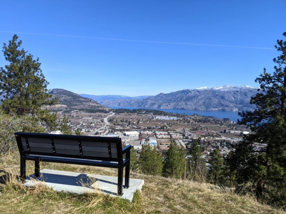
A Canadian flag, usually waving in the wind, waits at the top. It sits behind a large boulder, mounted on concrete.

Not only a great place to sit and admire the views, there is a time capsule buried underneath the summit boulder.
Placed at the summit for Canada’s 100th birthday in 1967 (Giant’s Head Park was created the same year), it will next be opened in 2067.
Beyond the summit flag, there’s a large fenced viewing area. It’s still a good idea to be careful near the edge, however, since it’s a very long way down! The wind can pick up at the edge too.
No matter which way you look from the Giant’s Head Mountain summit, there is something special to see.
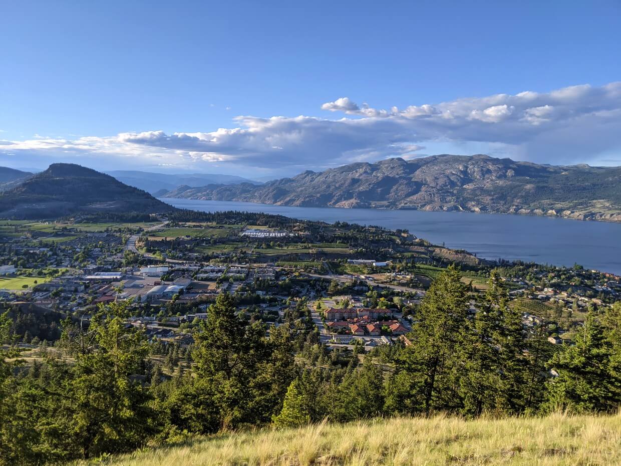
Check out the patchwork of vineyards across the water on the beautiful Naramata Bench, lined by the sparkling waters of Okanagan Lake.

Giant’s Head Mountain, Summerland: Essential details
- The Giant’s Head Mountain trailhead is easily and quickly accessible via Highway 97. Turn off at the Prairie Valley intersection (the one with Tim Hortons) in Summerland, make a left soon after on Atkinson, another left on Giant’s Head Road and then finally a right on Milne Rd
- The parking lot for the hike is found after 500m on the left. Parking is free. There is space for around 15-20 vehicles
- There is washroom building (open year round) just above the parking lot
- Giant’s Head is open 8am to 9pm, with the gate closed at 9pm
- Two small parking areas are available close to the top of Giant’s Head, with space for about 6-8 vehicles. I wouldn’t recommend driving a RV up. From the summit parking lot, it is a quick hike (500m) on a dirt trail to the Giant’s Head summit
- A number of benches can be found on the way to the top if you need a break. There’s an outhouse in the upper parking lot close to the summit
- A round trip from the lower parking lot takes around 2-3 hours, depending on your fitness, chosen trail and how much time you spend admiring the views at the top!
- Dogs are welcome on the designated trails, but must be on a leash
- Mountain bikes are restricted to the Roadway route and uphill on the East Ridge Trail only

Looking to book a stay in Summerland?
Summerland Waterfront Resort and Spa – Amazing location
Rosedale Motel – Good value
Dogwood Bed and Breakfast – Highly rated on Booking.com

Check out these other awesome hiking trails in the southern Okanagan area:
Kettle Valley Rail Trail, Penticton
Myra Canyon Railway Trestles, Kelowna
PIN or save this post for future reference with the below image!

Check out these other hiking posts next

One half of the Canadian/British couple behind Off Track Travel, Gemma is happiest when hiking on the trail or planning the next big travel adventure. JR and Gemma are currently based in the beautiful Okanagan Valley, British Columbia, Canada. Consider buying us a coffee if you have find any of our guides helpful!