In the mood for a BC road trip but want to go off the beaten path a little? This Nelson to Revelstoke road trip may be the adventure you’re looking for!
Combining beautiful lake scenery, dramatic waterfalls, forested valleys, rugged mountains and gold mining history, this itinerary is both interesting and visually compelling.
It promises relaxation too, with the chance to visit several dreamy hot springs en route.
Taking place in the West Kootenays, one of British Columbia’s quieter and less visited regions, there are fewer crowds to contend with as well.

JR and I first fell in love with the West Kootenays in 2017, on our first canoe trip on Slocan Lake. We returned the next year and the next…and now it’s one of our favourite areas of British Columbia. Visiting with friends, family and often by ourselves, we’ve tried to explore as much as possible.
In this post, I’ll share our favourite places to stop on a Nelson to Revelstoke road trip as well as useful tips to make the most of the journey.
There are affiliate links in this post. If you make a purchase via one of these links, we may receive a small percentage of the sale.

Nelson to Revelstoke road trip: Essential details
Before we jump into my recommendations for the coolest places to check out between Nelson and Revelstoke in BC’s West Kootenay region, I thought it’d be a good idea to share some background about the road trip route.
If you’re familiar with the area and just looking for ideas of where to go, feel free to skip ahead.
The most direct driving route between Nelson and Revelstoke is 250km. This includes a free ferry ride from Galena Bay to Shelter Bay.

A straightforward drive between these two small cities would take around 4 hours, assuming perfect timing with the ferry with no wait time or delays. I’ll explain more about the ferry later.
But this is a road trip where the journey is a huge part of the adventure. You’ll definitely want to stop at least a few times. For that reason, I’d recommend spending a couple of nights in this area.
As I describe in this post, I also suggest not taking the shortest route between Nelson and Revelstoke (Highway 6) and detouring via Kaslo instead (Highway 31/31A).

This extends the total trip distance by less than 20km and yet you’ll see so much more. And it’s really easy to backtrack and explore the ‘missed’ section if you have the time.
Honestly, it would be possible to spend a whole week of vacation in this area. I know we have done several times! Check out the overview below and then get planning.
If you want to know even more about this road trip, head to my BC/Alberta Travel Tips Facebook group and I’ll happily chat all things West Kootenays with you.
This area of BC is on the traditional territory of the Ktunaxa, Secwepemc, Syilx and Sinixt.
Nelson to Revelstoke map

Where to stop between Nelson and Revelstoke
Read on to discover our top picks for places to visit on a Nelson to Revelstoke drive. The following destinations are all close to the highway, unless noted as a detour.
I’ve written this road trip in a south to north direction but it can be driven in the other direction too. Living in the Southern Okanagan, we usually approach the area from the south.
This road trip can be combined with so many other BC road trips, such as our 2 week Western Canada road trip or Rockies road trip loop. It would be a great extension to an Okanagan Valley or Boundary Country itinerary.

Nelson
Before starting your road trip, take some time to explore the small city of Nelson.
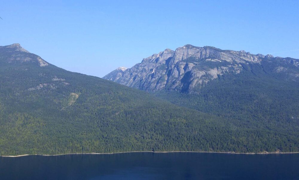
Situated on the West Arm of Kootenay Lake, Nelson has a vibe all of its own – an artsy community with plenty of interesting people. Gentrification over the last decade has pushed out some of the bohemian residents but the city still retains an independent feel.
This can easily been seen in the downtown area, which retains an incredible collection of restored early 19th century buildings. There are more heritage buildings here per capita than any other city in BC.
For an impressive view over the hilly city and lake beyond, head up to Pulpit Rock. This uphill hike is 3.6km round trip with about 340m elevation gain. The switchbacks are worth it!
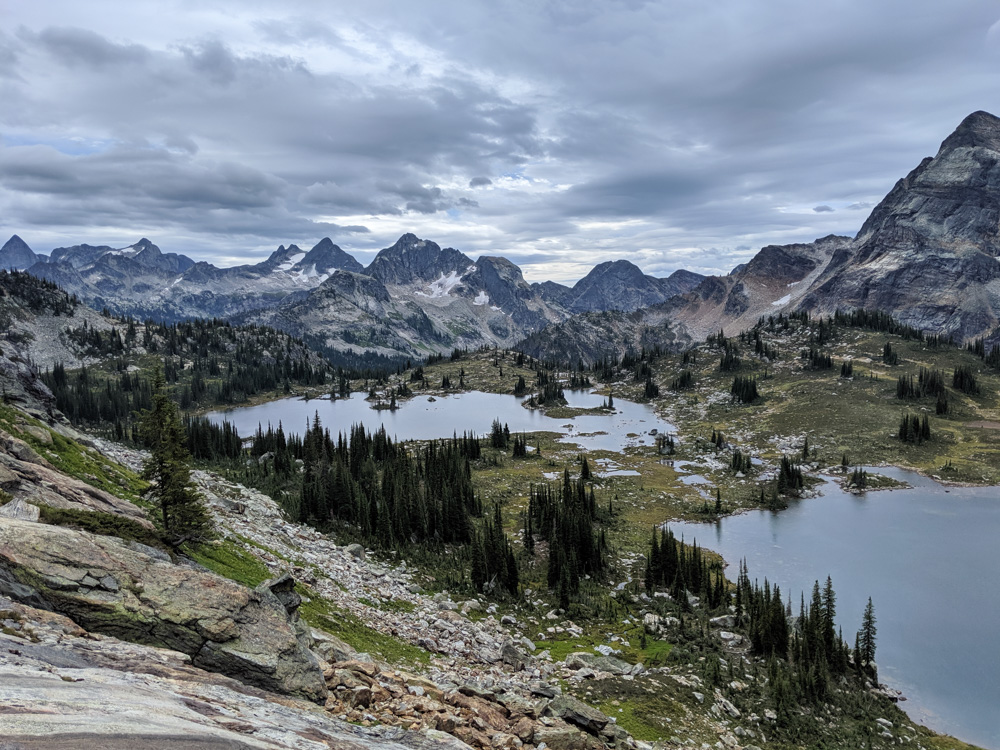
Detour: Kokanee Glacier Provincial Park
Not far from Nelson is the backcountry playground that is Kokanee Glacier Provincial Park. If you love hiking and have a suitable vehicle to drive the access road, a detour into this sub-alpine park is a must.
More than a dozen hiking trails traverse the mountains and lakes of this beautiful high-elevation landscape. The most popular route into the park’s alpine core is the Kokanee Lake Trail (15km return), a spectacular day hike in its own right.
The unpaved Kokanee Glacier Park Road leads to the trailhead. The 16km long road gains over 1100m as it climbs above Kokanee Creek. BC Parks suggests visitors should use a high clearance vehicle (no RVs) and I would agree. It is steep and has some juddery washboard sections.
For more details about Kokanee Glacier Park, head to our dedicated guide.

Ainsworth
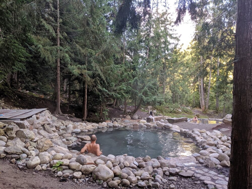
Established in 1883, Ainsworth is the oldest surviving community on Kootenay Lake. The main draw to this tiny village is the hot springs, which is one of my favourites in all of BC!
Ainsworth Hot Springs features both a hot mineral pool and a natural horseshoe-shaped cave system (complete with limestone stalactites!) Reservations are required for non-hotel guests, so keep that in mind when planning a trip.

The hot springs originate from the Cody Caves, which are located slightly northeast of Ainsworth. The temperature in the caves is a toasty 42°C, with the small main pool being a relatively cooler 35°C. There is a plunge pool as well.
Next door to Ainsworth Hot Springs is the Ainsworth Museum, set in the old J.B. Fletcher Store. It’s a real time capsule of a place, with goods and items dating back 100 years. Entry is by donation.
Feel like doing something active before chilling out in the pools? Guided tours of Cody Caves are available from late May to late October. The longest tour lasts 6.5 hours and includes climbing, ropes and ladders.

Kalso
Highway 31 continues to stay close to the lakeshore after leaving Ainsworth. A worthy stop is Fletcher Creek Falls. A short downhill trail leads down to a tall waterfall next to the lake (500m return). The beach is lovely here and there are a couple of free-to-use campsites.
Kaslo is a very pretty lakeside village. It may be small (around 1,000 residents) but it has great character and charm. It was founded just a few years after Ainsworth.

The community’s lively Front Street is lined with well preserved late 19th and early 20th century buildings, most occupied by independent local businesses. The Kaslo City Hall building, just around the corner, is a National Historic Site.
The SS Moyie, the oldest intact passenger sternwheeler in the world, is also a National Historic Site. It sits in a dry dock with an incredible lake and mountain backdrop.
Along with the railway, sternwheelers were once an intregral part of the local transportation network. There is an admission fee to go onto the boat.
For food and drink, we really like Angry Hen Brewing (under new ownership in 2025). They have a large sunny patio, bar service, a sold range of craft beers and some great non-alcoholic options as well.

Detour: Jumbo Pass and Monica Meadows
Adventurous travellers may want to continue detouring from Kaslo to hike in the Purcell Mountains. Kaslo is the closest community to a trio of incredible sub-alpine hiking trails – Monica Meadows, Jumbo Pass and the Macbeth Icefield.
We have personally hiked Monica Meadows and Jumbo Pass. They rank very highly on my list of the best day hikes in BC. Though these hiking trails are relatively short (10km return), they deliver truly spectacular mountain and glacier panoramas.
The best time to hike is late July to early October, with the very end of the season offering a beautiful display of golden larch trees in both locations.
Access to the trailheads is via the unpaved Glacier Creek Forest Service Road. I’d recommend a high clearance vehicle for the drive, especially for the last 5km to the Monica Meadows trailhead. Be prepared to drive slowly and expect the journey to take longer than anticipated.

Highway 31A and the Buchanan Lookout
From Kaslo, turn away from Kootenay Lake and take Highway 31A to New Denver. This winding forest route has quite a remote feeling at times. It climbs up from Kaslo quite steeply and continues mostly uphill to Fish Lake, where there is a small picnic area.
Driving a 4X4? Consider the 22km return side trip to Buchanan Lookout Recreation Site. The views of Kootenay Lake and the surrounding mountain ranges from this fire tower base are amazing!

Sandon
Not far from New Denver is the turn-off to Sandon. The West Kootenays region was once a hotspot for mining, particularly silver. It was once said that the local silver deposits were some of the most abundant in the world.
Sandon is a great example of a late 19th century mining community. At its peak, more than 5000 people lived here. The town had 29 different hotels, many saloons, an opera house, theatre, a red light district and two railway lines.

First destroyed by fire in 1900 then flooded twice, only a few buildings remain in Sandon today. One of these is the Silversmith Power and Light Generating Station. It was installed by Nikola Tesla in 1897 and still in operation.
This ‘ghost town’ is home to about 20 people, who are kept company by many relics of the past. One of those is a 1908 CPR steam train, which sits next to a collection of 1950s trolley buses from Vancouver.

Sandon is certainly an interesting place to explore. Access is along a 6km long unpaved road, which is usually in decent shape. Drive slowly to avoid the occasional potholes.
Somewhere I’ve always wanted to go from Sandon is Idaho Peak. Until 2020, there was an unpaved road almost all the way up to the top of this 2280m peak. After being washed out by flooding, it is now closed indefinitely – I mention it just in case there is a sudden reopening.

New Denver
New Denver is a small community (pop. 500) overlooking Slocan Lake and Valhalla Provincial Park. It is the location of the original Valhalla Pure Outfitters store.
Take the opportunity to learn about the darker side of the history of this area at the Nikkei Internment Memorial Centre. It shares some of the stories of the 22,000 Japanese Canadians who were forcibly removed from their homes on the BC coast and sent to internment camps during WWII.

The New Denver camp became the third biggest in the province. There were other internment sites in the Slocan Valley (Rosebery, Slocan City, Lemon Creek) as well as in Sandon and Kaslo. There is an admission fee to visit this National Historic Site.
The popular Galena Trail, the former route of the Nakusp and Slocan Railway, runs from New Denver to nearby Rosebery. It is ideal for a half day biking adventure, as recommended by my friend Leigh from hikebiketravel.com.
Rosebery has a 34 site provincial park campground. Waterfall chasers may want to make the effort to check out 63m high Wilson Creek Falls (12.5km one-way on an unpaved road).
Detour: Silverton, Slocan and Valhalla Provincial Park
Highway 6 travels the length of Slocan Lake and continues to eventually link up with Highway 3A (near Nelson). If you have some extra time or would prefer to drive a circle route, head south towards Slocan.
The first community along the route is Silverton, technically BC’s smallest municipality by area. There is good access to the lake for travellers craving a swim!
A little further along is the Slocan Lake View Point, which offers panoramas across the lake to the beaches, forested valleys and snow capped peaks of Valhalla Provincial Park.
Sadly, the park’s lakeshore was significantly impacted by wildfires in the summer of 2024. The waterfront areas remain closed at the time of writing, but most of the alpine areas are accessible again.
Gwillim Lakes and Gimli Ridge are two such places. Both are incredible day hiking destinations, with Gwillim also being the perfect destination for a 1 or 2 night backpacking trip. It is well worth making the journey to either location – more details in our Valhalla Provincial Park guide.
Slocan is another community that was once a mining boomtown. It’s a lot quieter now but has a great beach area and some great restaurants, such as the Bliss Café and the historic Lobby Grill.
Nakusp
After losing sight of Slocan Lake, it’s not long before another lake appears – Summit Lake! There is a lakeshore rest area at the eastern end and a provincial park campground to the west.
The next small lake, Box Lake, has a low cost Recreation Site campground as well.

The fourth and final lake along this stretch of road is Upper Arrow Lake. The village of Nakusp sits on its shores. With around 1,600 residents, Nakusp is the largest community between Nelson and Revelstoke. It offers a choice of restaurants, shops and accommodation.
The paved Nakusp Waterfront Walk is ideal for an easy and scenic stroll. There is a municipal beach and park on the northwestern side.
From Nakusp, it is possible to drive to the Okanagan Valley. Highway 6 leads to the city of Vernon. It is a very popular road for motorcylists due to its many winding curves!

Nakusp Hot Springs, Halcyon Hot Springs and Halfway Hot Springs
The Nakusp area is best known for hot springs – there are three developed springs within a short drive as well as more undeveloped (and harder to reach) options.
Nakusp Hot Springs is situated in a river valley in the Selkirk Mountains, about 14km from Nakusp itself. Community-owned and operated, this hot springs facility is compact with the main pool area separated into two half circles (warm and hot).
Halcyon Hot Springs has views of Upper Arrow Lake and the Monashee Mountains. Part of a resort, this hot springs has an upscale spa-like atmosphere.
The soaking experience is usually calming, with soft music and sunbeds. There is a hot pool, large warm pool, cold plunge and mineral swimming pool (summer only).

Halfway Hot Springs is set into a beautiful forest next to the Halfway River. It is semi-developed, with three mineral pools, all created with rocks from the river. More hot spring outlets can be found closer to the river. There is no admission fee.
To reach the springs, you must drive 11km down a usually well-maintained unpaved road (prepare to see logging traffic). There is a Recreation Site campground nearby as well.
Gelena Bay to Shelter Bay ferry
This Nelson to Revelstoke road trip includes a free ferry ride from one side of Upper Arrow Lake to the other. The ferry can take 80 vehicles and 250 passengers at a time. It is first come, first serve with no reservations.
There are usually around 20 crossings every day, with one every hour. The journey takes 20 minutes and offers views down the lake.

Be sure to arrive at least 10-15 minutes before the ferry departure time, earlier if you are on a schedule and want to ensure a spot (or are driving a larger vehicle)
Please note that ferry refueling and dangerous cargo sailings happen on select days/sailings and can impact the schedule.
Before heading to the ferry, make sure you visited roadside Ione Falls. This roadside waterfall is just south of Halcyon. Blink and you may well miss it! There are some picnic tables if you’d like to stay for a while.

Sutherland Falls and Begbie Falls
Back on the road, there are two more stops I’d recommend before arriving in Revelstoke.
The first is Sutherland Falls, located in Blanket Creek Provincial Park. This powerful waterfall drops 13m into a mossy canyon. It is very easy to reach; less than 10 minutes walk along a flat path from the parking area.
Begbie Falls is next, a twin waterfall also very close to Highway 23. There are two ways to access it, with the quickest being a drive along the narrow and unpaved Clough Road and Begbie Falls FSR. High clearance vehicle is best or be prepared to drive very slowly.
The longer way involves a 5km return hike on the Bluff Trail. The trailhead is located at the Begbie Bluffs parking area on the highway. The path is 200m downhill to the falls so prepare for it being uphill all the way back!

Revelstoke
Welcome to Revelstoke! This cool yet down-to-earth mountain town has a great community feel and so many things to do. Here’s some ideas:
- Stroll the historic downtown area, filled with many independent shops and restaurants
- Drive the scenic 26km Meadows in the Sky Parkway into the subalpine of Mount Revelstoke National Park (Parks Canada pass required)
- Ride the 42km/h Pipe Mountain Coaster down the slopes of Mount Mackenzie at Revelstoke Mountain Resort
- Explore the shores of Lake Revelstoke, a 130km long reservoir created by the Revelstoke Dam
- Relax with a beer on the sunny patio at Mt Begbie Brewing with views of namesake Mount Begbie
- Walk the short Giant Cedars Boardwalk Trail into the heart of an old growth forest in Mount Revelstoke National Park (Parks Canada pass required)

Useful tips: Nelson to Revelstoke road trip
Before planning your trip, here’s a couple of things to keep in mind.
What to expect
- The West Kootenays is a quiet, laid back and occasionally quirky region. Locals love to hike, bike, boat, swim in the lakes and relax. If you’re looking for big city amenities, this may not be the destination for you!
- While there are tourists, most visitors will be from British Columbia or Canada more generally. So if you like the idea of getting a more local experience, this region delivers.
- Some places in this area can feel remote. Cell phone service outside of communities can be spotty in places. Be sure to share your trip plan with a friend or family member, just in case.
Best places to stay
Ainsworth is good place to be based for a few nights – enjoy the hot springs, visit Fletcher Creek Falls and explore Kaslo.
Hotel guests at the Ainsworth Hot Springs Resort receive complimentary access to the hot springs, with no reservation required.
We really like the Ainsworth Hot Springs Suites, which are located right across from the hot springs. We’ve stayed in the upper suite twice – it has two bedrooms, a fully equipped kitchen and wonderful views of the lake. There is beach access too.

Nakusp is a good pick if you’d prefer to be in a place with more local amenities.
The Lodge at Arrow Lakes is close to the waterfront and is highly rated. Halcyon Hot Springs, a little further north, has a range of suites, cottages and chalets. Access to the hot springs is included. Super nice but the pricing is on the premium side.
For camping in the region, Kootenay Lake Provincial Park’s lakeside campgrounds (Davis Creek and Lost Ledge) are lovely. They are both within 30 minutes drive north of Kaslo.
McDonald Creek Park is another wonderful provincial park campground. It is situated on the shores of Upper Arrow Lake, not far south of Nakusp.
Halfway Hot Springs Recreation Site campground is on the rustic side but very convenient for the nearby hot springs. There are 30 sites, all available on a first come, first served basis only (no reservations). The 10 walk-in tent sites are located close to the river and offer a lot more privacy.

Outdoor safety
Some of the most popular hiking trails in the region are in remote areas (e.g. Valhalla, Kokanee Glacier). Expect zero cell phone service. Tell someone where you are going and when you will be back or check in again. A satellite communciator, like an Inreach, can be helpful for peace of mind.
Carry a decent spare tire and know how to change it. On some roads, a recovery vehicle may take some time to arrive. Travel with some food and water, just in case.
The West Kootenay region is home to both both grizzly bears and black bears. It’s important to know the difference and understand what to do if you do see one.
Minimise the chance of bumping into a bear on a hiking trail by making noise (talking, singing, clapping), hiking during the day and staying alert (look for diggings, scat, footprints).
I always carry bear spray in an easily accessible place while hiking. This aerosol deterrent is designed to be deployed at close range (less than 10m) when facing an aggressive bear. When used properly, bear spray is extremely effective..
Keep dogs on a leash to avoid negative wildlife encounters. Dogs are not permitted on some trails in this area (e.g. Valhalla Provincial Park, Kokanee Glacier provncial Park.
In higher elevation areas, porcupines are notorious for chewing vehicle brake lines in parking lots. Some people argue it is unlikely but nonetheless, many alpine hiking trailheads will have a stash of chicken wire, rocks and wood for creating a barrier around your vehicle.

Other posts you may find helpful
The Best Vancouver to Calgary Road Trip Routes: Highway 1 & Alternatives
17+ of the Best Day Hikes in British Columbia
The Best Hot Springs in BC: Complete Guide + Map
BC’s Best Backpacking Trips: Our Favourites and 60+ More Suggestions
17 of the Best Canoe Trips in British Columbia


One half of the Canadian/British couple behind Off Track Travel, Gemma is happiest when hiking on the trail or planning the next big travel adventure. JR and Gemma are currently based in the beautiful Okanagan Valley, British Columbia, Canada. Consider buying us a coffee if you have find any of our guides helpful!