The Okanagan Valley is one of the best road trip destinations from Vancouver.
This desert-like playground in British Columbia’s interior is renowned for its awe-inspiring lakes, range of outdoor activities and delicious wine.
Without stopping, the average Vancouver to Okanagan Valley road trip takes around 4 to 5 hours. The journey is remarkable in its own right, as you travel from the lush temperate coast to the dry, hot climes of BC’s interior region.

Living in Penticton, we drive between Vancouver and the Okanagan Valley at least four times a year. For that reason, we like to think we know this road trip route pretty well!
With that in mind, this post will share our favourite places to stop when driving between Vancouver and the following Okanagan Valley destinations:
Looking for advice on the best activities in the Okanagan Valley? Check out this Okanagan Valley road trip guide.
Whether you visit on a dedicated weekend getaway or as part of a longer Western Canada adventure, I hope this Vancouver to Okanagan Valley road trip guide will help you plan the perfect itinerary to make the most out of your journey.
These road trip routes travel across the traditional territory of multiple First Nations, including the Syilx, kʷikʷəƛ̓əm, Qayqayt, Musqueam, Tsleil-Waututh, Stz’uminus, Stó:lō, Nlaka’pamux, Secwépemc and Semiahmoo.
There are affiliate links in this post. If you make a purchase via one of these links, we may receive a small percentage of the sale.
Vancouver to Okanagan Valley road trip overview
Before I get into my recommendations for the best places to visit between Vancouver and the Okanagan Valley, I thought it would be a good idea to share an overview of the route options.
To travel from Vancouver to the Okanagan Valley, it is necessary to cross several mountain ranges.
The most significant is the Cascade Mountains range, where the tallest peaks soar to 2200m. Due to their proximity to the Pacific Ocean, the western slopes of the Cascades receive a huge amount of rain and snow each year.

Highway 3 crosses the Cascades to the south and travels to the southern Okanagan Valley, closest to Penticton and Osoyoos.
Highway 5 traverses the northeast Cascades. The Hope to Merritt section of Highway 5 is known as the Coquihalla (or ‘the Coq,’ pronounced like ‘coke’).
With an annual snowfall of 11 metres, the Coquihalla has the reputation for being one of the most treacherous driving routes in all of North America (it is even the subject of a long running TV show!) The highest point on the Coq is 1244m.
Upon reaching the town of Merritt, drivers on Highway 5 must then switch to Highway 97C.
Also known as the Okanagan Connector, this highway is the second highest in British Columbia (1728m) and also receives a lot of snow. It ends near the community of Peachland in the central Okanagan Valley.
Highway 97, also known as the Okanagan Highway, runs the length of the Okanagan Valley, connecting the communities of Osoyoos, Penticton, Peachland, Kelowna and Vernon. It then continues northwest to Kamloops.

Vancouver to Osoyoos road trip
Osoyoos is the most southern town in the Okanagan Valley, sitting just above the US border. Osoyoos is best known for its hot, dry summers (the average daily temperature is 28°C) and for being located next to Canada’s warmest freshwater lake.
Hundreds of acres of vineyards and orchards surround the town of Osoyoos and the lake of the same name. The semi-arid landscape is commonly compared to a desert, with cacti, rattlesnakes and tumbleweed all present.
Needless to say, Osoyoos is a very popular summer destination. I’d argue though that it is also a great place go in spring and fall, when the weather is still warm, the hotels are cheaper and the wineries quieter. Regardless of when you go, there are so many things to do in Osoyoos.
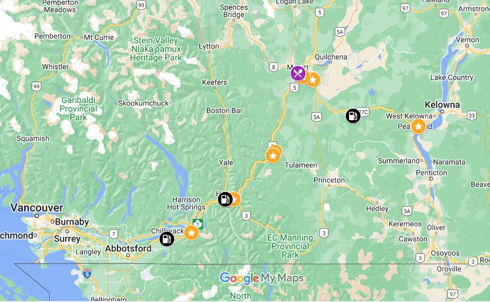
Vancouver to Osoyoos road trip map

Route overview
Leaving Vancouver, follow Highway 1 east. The fastest and most direct route to Osoyoos is via Highway 3, which begins in Hope and travels all the way to Osoyoos.
Without stopping, the 400km journey from downtown Vancouver to Osoyoos takes around 4 hours and 30 minutes. Of course, factors like traffic and construction will make that trip time longer.
With a couple of sightseeing stops and restroom breaks, plan for your Vancouver to Osoyoos road trip to take around 7 hours.
Looking for somewhere to spend the night on the way to Osoyoos? My top pick would be Manning Park Resort, especially if you like to hike. It is located just over halfway.

Where to stop
If getting to the Okanagan Valley is your priority, plan to drive Highway 1 directly to Hope.
Vancouver to Hope
Depending on your gas level leaving Vancouver, you may want to top up in Chilliwack. Abbotsford usually has the cheapest gas prices in the Lower Mainland area but we find the Chilliwack gas stations quicker and easier to access.
Visitors new to British Columbia may enjoy a stop at Bridal Veil Falls just west of Hope. Located just off Highway 1, the return driving detour is around 10 minutes (5km). The short but steep loop trail to the base of the impressive falls takes around 30 minutes to walk.

In need of some caffeine, snacks or breakfast/lunch? Check out the modern yet cosy Blue Moose Coffee House in Hope (10 minute detour). Fun fact – First Blood, the original Rambo movie, was filmed in Hope!
Just two of the best things to do in Hope are the Othello Tunnels (easy, mostly flat walk) and the Hope Lookout (moderate, steep hike). The latter takes around 3 hours.
The Othello Tunnels are a series of old train tunnels cut through granite rock. The park has only recently fully reopened again after flood damage and the trail through the tunnels temporarily closed again for the wetter months (November onwards).
Onto Highway 3! Please note that there is only one gas station between Hope and Princeton.

Hope to Princeton
About 15 minutes after Hope, the highway enters E.C. Manning Provincial Park. There is a picnic area with outhouses at the western gate – look for the giant marmot statue.
An alternative picnic spot would be Lightning Lake (further 47km, 10 minute detour).
Highway 3 runs through Manning Park for 60km. The road is mostly two lane (four total lanes), though there are some curvy one lane sections as well. Phone signal is very limited on this stretch.
Driving this route between mid July and mid October? A must-do is the drive up to the Cascade Lookout, accessed via the paved 7.8km long Blackwall Road. The views of the valley are spectacular.
Blackwall Road continues 6km after the lookout and leads to alpine meadows, which come to life with wildflowers in late July. If you have the time and your own vehicle (not a rental, as the road is not paved), I’d recommend the side trip.
The landscape noticeably starts to change after Manning Park, becoming much more dry. The trees are sparser too. Some of this highway’s sharpest turns and highest hills are just ahead.

Princeton to Osoyoos
Princeton is an ideal gas, snack and lunch/early dinner stop. The Copper Pit serves up reliably good pub-style favourites. The modern Visitor Center has friendly staff and great washrooms.
Feeling hot and have time on your side? Bromley Rock Provincial Park is a popular place to wade and swim in the Similkameen River, though some caution is needed (currents can be strong in late spring, early summer).
If you need it, there is a small rest area 5km from the village of Keremeos. Try to spot bighorn sheep on the slopes of the surrounding mountains.
Keremeos must be the fruit stand capital of British Columbia! The produce is fresh and usually pretty cheap. Our favourite stand is Peach King Orchards, but honestly, you can’t go wrong.
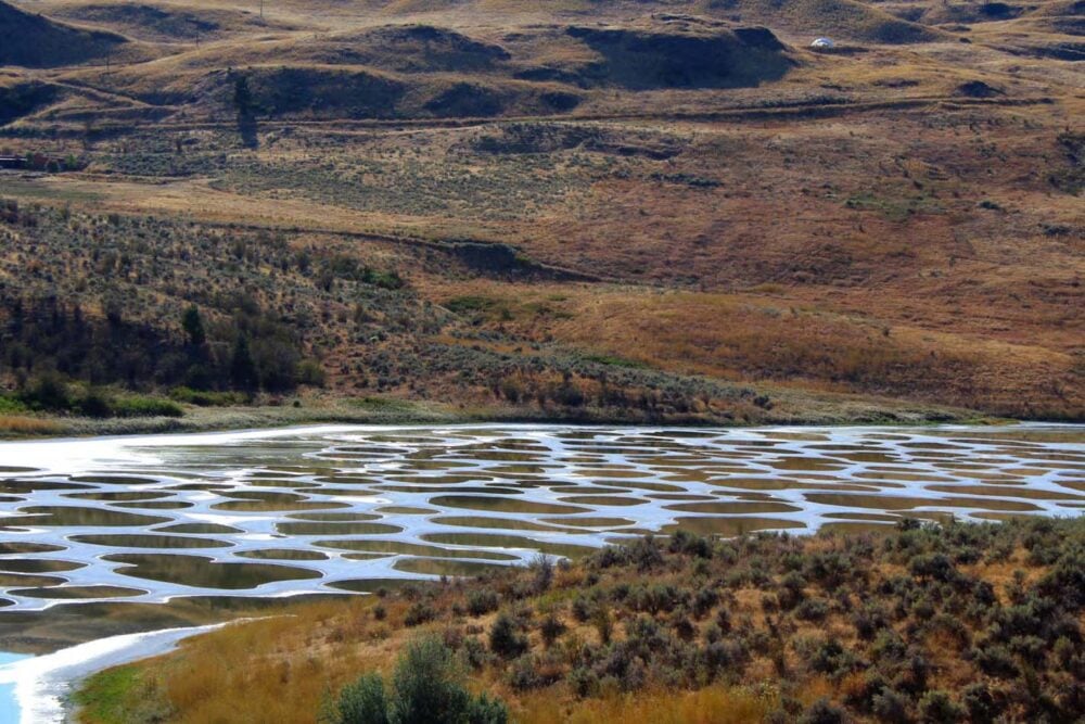
The final stop on this Vancouver to Okanagan Valley road trip route is the Lake Khiluk/Spotted Lakes Lookout (9km from Osoyoos). This culturally sacred site has to be seen to be believed!
Where to stay in Osoyoos
The Watermark Beach Resort is my top pick for where to stay in Osoyoos, BC. Located right beside the lake, the hotel is also only 5 minutes walk from a choice of restaurants and shops. Osoyoos’ craft brewery is in the same building.
Choose between swimming in the lake or in the on-site pool. All suites have a full kitchen as well as separate dining and living rooms. If budget isn’t an issue, consider booking one of the fabulous beachfront townhomes.
Spirit Ridge is a close second choice, with its spectacular position overlooking vineyards and Osoyoos Lake. There is a heated outdoor pool, hot tub and highly rated restaurant.
Budget-conscious travellers would do well to check out Westridge Motor Inn. The clean, well decorated rooms have everything you need for a few days in Osoyoos and provide excellent value for money. There’s an outdoor pool too.
Vancouver to Penticton road trip
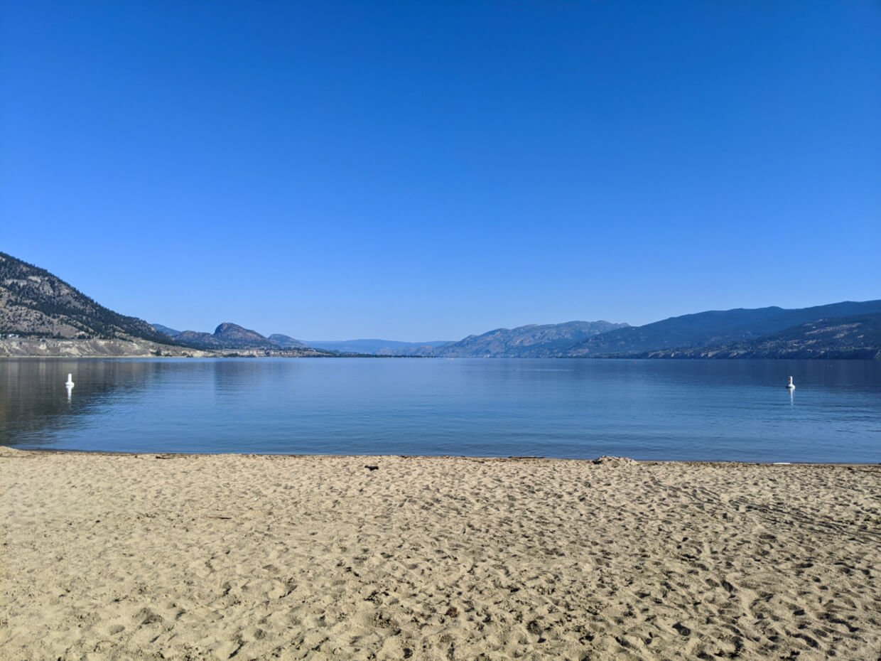
The city of Penticton is situated almost halfway between Osoyoos and Kelowna. In my mind, it’s the perfect blend of both – quieter than Kelowna, but more ‘happening’ than Osoyoos.
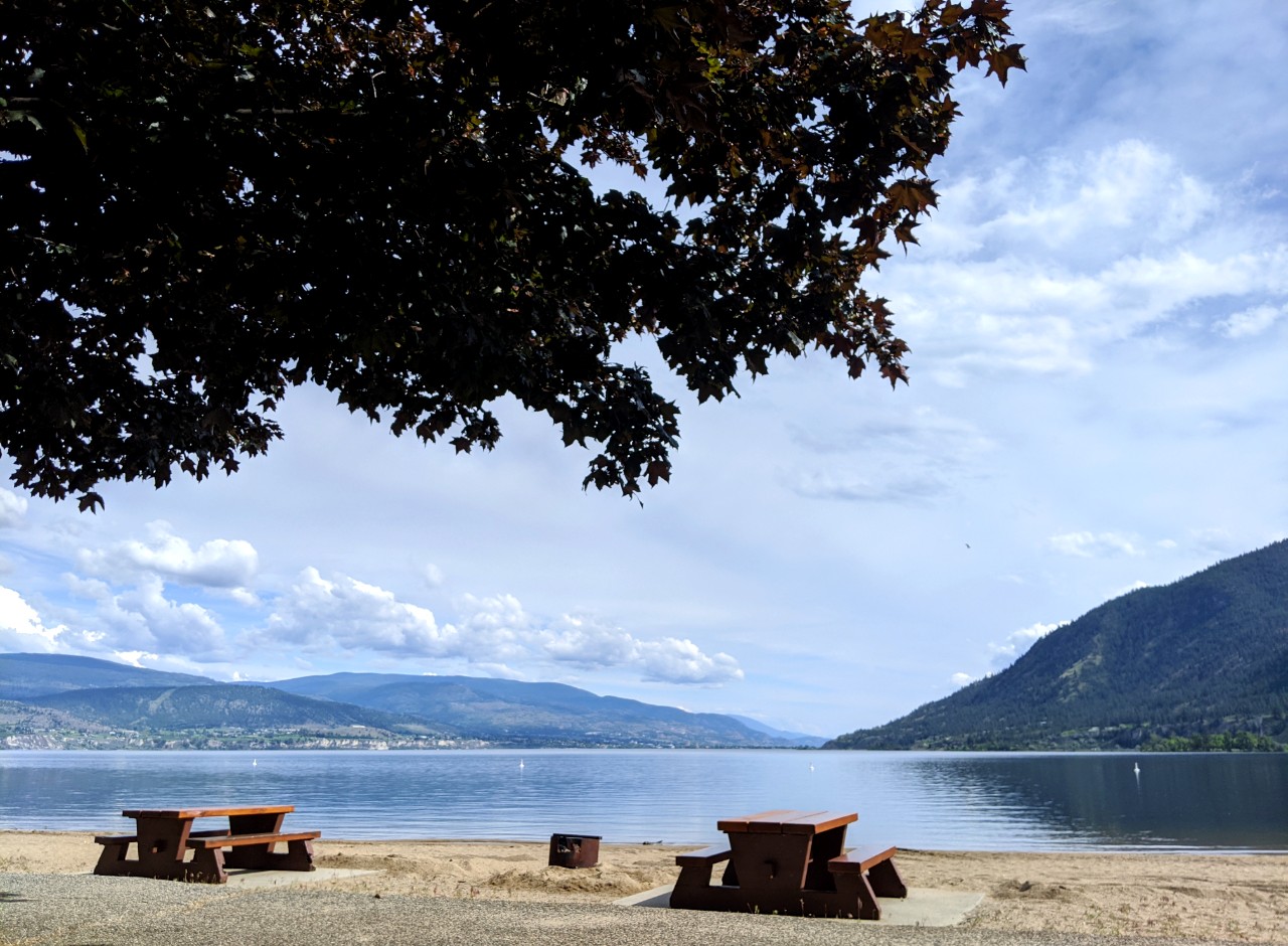
And, of course, the setting is incredible. Penticton is one of only two cities in the world set between two lakes. A series of golden beaches line the shore, bordered by vineyards and orchards. Forested mountains surround it all.
A bonus of the double lake setting is the cooling lake breeze. This is very welcome in summer when temperatures are often in the 30s.
More than 50 wineries are reachable within 20 minutes of Penticton’s downtown area. Most are clustered on the Naramata Bench, a gorgeous 20km stretch of elevated land along the south-eastern shore of Okanagan Lake, British Columbia.
No matter when you go, there are SO many things to do in Penticton. We live in Penticton and are therefore a little biased, but I think it’s easy to have a good time here!
Vancouver to Penticton road trip map

Route overview
There are two main ways to drive from Vancouver to Penticton:
- Manning Park route via Highway 3, Highway 3A and Highway 97 (similar routing as Vancouver to Osoyoos)
- Coquihalla Route via Highway 5, Highway 97C and Highway 97 (similar routing as Vancouver to Kelowna)
While the Coquihalla route is longer (420km vs 400km), it usually takes less time to drive. The Manning Park route is around 4 hours 50 minutes compared to 4 hours 30 on the Coquihalla.
We alternate between these two routes often, depending on our schedule and the type of vehicle we’re driving (van vs. car).
While the Coquihalla route is faster (up to 120km/h), we find we use more gas driving it due to the prolonged ascents. With our van, this can prove to be very expensive.
The Coquihalla is also busy, especially with commercial truck traffic. That in combination with the highway being more vulnerable to bad weather, we usually avoid driving the Coquihalla in winter.
The Manning Park route is slower but quieter. I also find it prettier, with more possible (and interesting) places to stop. Some people find the scenery on the Coquihalla to be more dramatic.
Whichever route you take, plan for your Vancouver to Penticton road trip to take around 7 hours with a couple of sightseeing stops and washroom breaks.
Looking for somewhere to spend the night on the way to Penticton via Highway 3 route? If you like hiking, I would strongly recommend Manning Park Resort. It is located just over halfway.

Where to stop – Highway 3 (Manning) route
Driving from Vancouver to Penticton via Highway 3 is very similar to the road trip route from Vancouver to Osoyoos.
The difference is the final section, from Keremeos to Penticton. Instead of following Highway 3, Penticton-bound travellers should turn onto Highway 3A for the most direct route.
The 3A connects with Highway 97, which traverses straight through the city of Penticton. There is a rest area at the western edge of Yellow Lake.
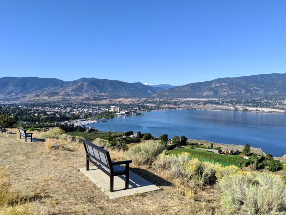
My top recommendation for this final section of your journey is to stop briefly at the Highway 97 viewpoint. It offers great views of Skaha Lake and Skaha Bluffs Provincial Park. Besides that, enjoy the scenic drive!

Where to stop – Highway 5 (Coquihalla) route
Driving from Vancouver to Penticton via Highway 5 is very similar to the road trip route from Vancouver to Kelowna (as detailed later in this guide).
Again, the difference is the final section, from the end of Highway 97C to Penticton. At the junction, turn onto the southbound Highway 97.
Scenic Highway 97 follows the edge of Okanagan Lake through the communities of Peachland and Summerland. Highway 97 can be very busy in the summer months so it can be a slow journey.
A must do along this route is the short detour to Hardy Falls. The 1.6km return walk through the canyon to the waterfall is completely flat. The cascade is strongest from April to July. Salmon run in the river in September.
Sun-Oka Beach Park is also worth a stop, especially for roadtrippers with dogs. The 500m long stretch of golden sand is one of the best in the entire Okanagan Valley. There is a separate dog beach.
Where to stay in Penticton
Without a doubt, the best place to stay in Penticton is the West Wing of the Penticton Lakeside Resort.
The location of this hotel is absolutely superb – right on Okanagan Lake, with views of the beach and water and yet only blocks from a choice of breweries, restaurants and coffee shops.
The six-storey West Wing is one of the largest wooden structures in British Columbia. The thoughtfully designed rooms are super modern and have private balconies.
If the Lakeside is out of your budget, consider one of the many motels along Lakeshore Drive. Tiki Shores is one of the best rated properties in this area.
Is wine tasting your number one reason for visiting Penticton? Wesbert Winery and Guest Suites is located right on the Naramata Bench, with views of vineyards from each of the upscale B&B rooms. Several other wineries are within easy walking distance.

Vancouver to Kelowna road trip
Kelowna is the Okanagan Valley’s biggest city and also one of Canada’s fastest growing (metro population of 235k). And it’s easy to see why.
The city showcases all of the urban attractions you can ever want (breweries, upscale restaurants and bars, multiple clubs, malls, marinas, and golf courses) with a backdrop of beautiful Okanagan Lake plus orchards, farms and vineyards.
And, of course, the weather is just as hot and dry as everywhere else in the Okanagan!
For those feeling active, know that the hiking opportunities are great too. Knox Mountain Park hosts a network of scenic trails just minutes from downtown (though be sure to start early in summer!)
Vancouver to Kelowna road trip map
Route overview
Leaving Vancouver, follow Highway 1 east. The fastest and most direct route to Kelowna is via Highway 5, which begins just outside of Hope.
Kelowna-bound drivers must follow the length of Highway 97C from Merritt to Peachland, then switch onto Highway 97 to reach Kelowna.
Without stopping, the 390km journey from downtown Vancouver to Kelowna takes around 4 hours and 20 minutes. Traffic and construction can extend that time.
In my opinion, this Vancouver to Okanagan Valley road trip has less obvious sightseeing stops than the others mentioned. I would still plan for your trip to take around 7 hours if you need to buy food, get coffee etc.
If you have the time and/or the weather conditions on the Coquihalla look a bit hazardous, consider driving to Kelowna via Highway 3. While the route is longer (460km, 5 hours 30 minutes), the road is quieter and located at lower elevations.

Where to stop
If getting to the Okanagan Valley is your priority, plan to drive Highway 1 directly to Hope.
Vancouver to Hope
Depending on your gas level, you may want to top up in Chilliwack. While Abbotsford usually has the cheapest gas prices in the Lower Mainland area, we find that the gas stations in Chilliwack easier (and quicker) to access.
Visitors new to British Columbia may enjoy a stop at Bridal Veil Falls just west of Hope. Located just off Highway 1, the driving detour is around 10 minutes (5km). The loop trail to the base of the impressive falls takes around 30 minutes to walk.
In need of some caffeine, snacks or breakfast/lunch? Check out the modern yet cosy Blue Moose Coffee House in Hope (10 minute detour). Fun fact – Rambo was filmed in Hope!

Hope to Merritt
If travelling outside of the winter months, I’d recommend bypassing the start of Highway 5 and travelling to Coquihalla Canyon Park.
A flat, easy 3km return walk travels through a series of old train tunnels cut through granite rock. A more difficult but also scenic alternative is the Hope Lookout Trail.
Either way, your journey continues on Highway 5. Please note that there are no gas stations between Hope and Merritt, so be sure to check your gas level before leaving town.
From Hope, Highway 5 travels northeast to Merritt via the Coquihalla Canyon. While driving, you’ll be able to spot the Coquihalla River, many mountain peaks and some impressive rock faces. The highway travels through a number of tunnels as well.
There are two very good rest areas around the summit area – Coquihalla Lakes and Britton Creek (the latter is the nicer of the two). The scenery around the highway becomes drier and drier as you approach Merritt.

Merritt to Kelowna
The town of Merritt is located just a few kilometres away from the junction of Highway 5 and Highway 97C. A small town set in a calming landscape of rolling grasslands, Merritt acts as a gateway into British Columbia’s vast interior region.
If you need gas or food supplies, be sure to take a break in Merritt. There are very few services for the next 105km.
Our favourite place to eat in Meritt is the Kekuli Café, a locally owned Indigenous cuisine restaurant. The Wild Salmon Taco is so fresh yet filling. Be sure to pick up some handmade Saskatoon bannocks for the road.
A great place to stretch the legs used to be the 1.9km Godey Creek Trail, situated close to the old Visitor Center at the 97C junction. There is now development in this area and access seems a little more complicated (the trailhead has apparently been moved past the second cattlegrid).
An alternative would be the Laurie Guichon Memorial Grasslands Interpretive Site, a very short detour from Highway 97C. There is an easy 750m long trail to a viewing platform over a pond. Washrooms can be found in the parking lot.
The 97C is British Columbia’s second highest highway. We’ve seen light snowfall here in mid May before. The drive includes a very long climb up to Pennask Summit, with a slow descent on the other side. There is a gas station at Elkhart.
Get your first glimpse of the Okanagan Valley at the Inspiration Centre rest area. Head north at the Highway 97 junction and Kelowna is just 30 minutes away (traffic dependent).

Where to stay in Kelowna
My top recommendation for accommodation in Kelowna is the Hotel Zed. This renovated motel is situated right across from Kelowna City Park, which borders Okanagan Lake.
The rooms are cleverly designed with a modern yet funky aesthetic. Guests have access to a number of great amenities, such as a rooftop patio, hot tub, swimming pool and even a table tennis room.
For a more upscale stay in Kelowna, check out The Royal Kelowna. This luxurious resort is also less than five minutes walk from Okanagan Lake. All suites have well equipped kitchens. The star of the show is an infinity pool on the roof.
Kelowna hosts all of the chain hotels and motels you may expect. The Coast Capri Hotel is a reliable pick, with easy access to downtown and wineries. There are two on-site restaurants as well.
Vancouver to Vernon road trip
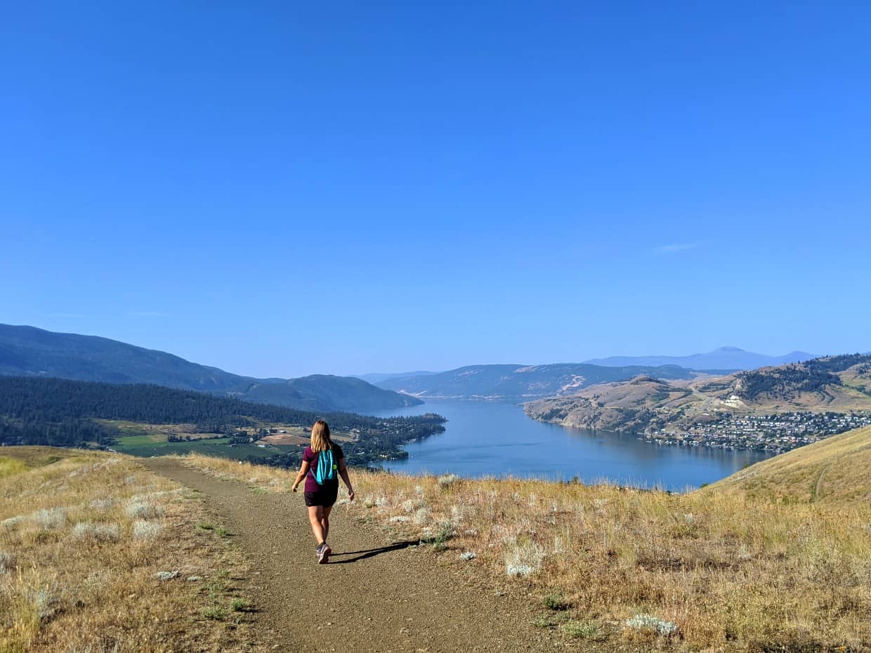
Vernon is the most northernmost city in the Okanagan Valley. Hot summer weather is still a given here, though the temperatures are usually a few degrees cooler.
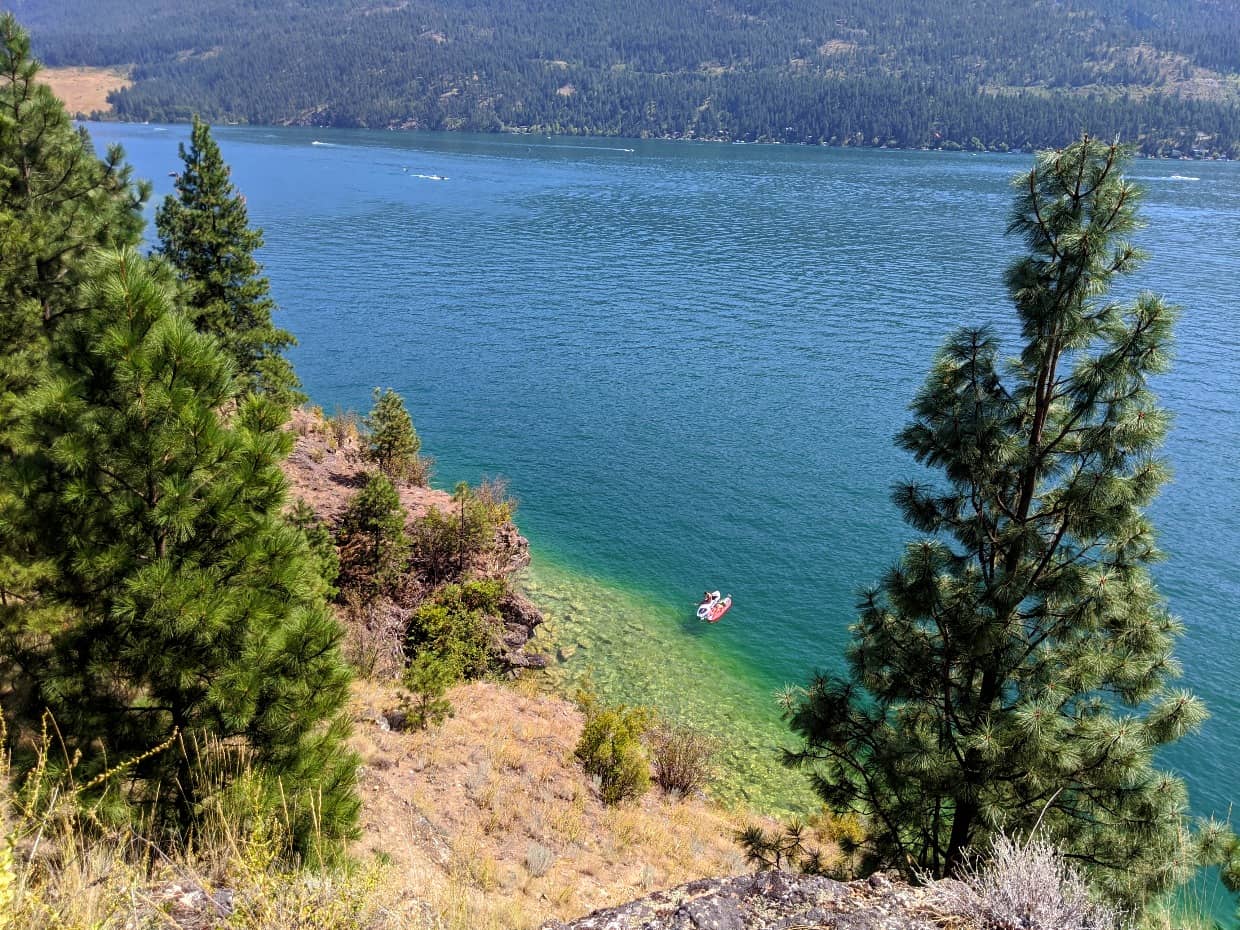
Situated close to three gorgeous lakes (Okanagan, Kalamalka and Swan), it’s easy to find a place to cool off in Vernon.
Kalamalka Lake is the most beautiful of the three, shimmering turquoise during the summer months, a result of naturally occurring calcium carbonate crystals.
The best beaches in town are found at Kal Beach and in Kalamalka Lake Provincial Park. If you like to hike and bike, Vernon may just be your ideal destination. When visiting in summer, head out on the trails early!
With Vernon being our go-to getaway destination in the last couple of years, we can tell you that there are many other great things to do in Vernon.
Vancouver to Vernon road trip map

Route overview
The most direct and fastest way to drive from Vancouver to Vernon is via Highway 5, Highway 97C and Highway 97. The majority of the journey follows the same path as the Vancouver to Kelowna route as described above.
Without stopping, the 445km journey from downtown Vancouver to Vernon takes just over 5 hours to drive. Factors like traffic and construction will extend that journey time.
There is an alternative, but longer, route from Vancouver to Vernon via Highway 1 and Highway 97 (Falkland). The total length is 470km with the drive taking around 5 hours and 30 minutes.
Where to stop
As noted above, the Vancouver to Vernon road trip route is almost the same as the journey from Vancouver to Kelowna (so go read that section first!)
The difference is the final section, from Kelowna to Vernon. The route is a tale of two halves. The first part involves driving straight from the heart of Kelowna, past seemingly endless traffic lights and strip malls.*
The airport signifies the end of Kelowna and the imminent arrival of the small municipality of Lake Country. More traffic lights await.
A good way to break up the journey is to stop at Kaloya Regional Park. The small park offers the chance to see the beautiful turquoise colours of Kalamalka Lake up close. There is an easy walking trail and beach access.
Enjoy the views and fast drive towards Vernon as the highway travels high above the lake. There is an excellent lookout/picnic area just before the descent into the city.
*If the idea of driving through traffic doesn’t appeal and you have some extra time, consider taking Westside Road from Kelowna instead. This scenic road travels along the western shore of Okanagan Lake. The route is longer (+30 mins) and windier than Highway 97.

Where to stay in Vernon
Fortunate to have stayed in a few different places in Vernon over the last few years, we have a comprehensive Vernon accommodation guide.
In my opinion, the ultimate place to stay in Vernon is Sparkling Hill Resort. This spectacular adults-only health and wellness resort hosts the largest spa in Canada. Go on, treat yourself.
Essential travel tips: Vancouver to the Okanagan Valley road trip
Before I go, I’ll leave you with what I think are essential travel tips for your drive between Vancouver and the Okanagan Valley.
What to expect
- The best time to drive from Vancouver to the Okanagan Valley is mid May to October. During this time, the weather is usually warm, the highways are clear of snow and the majority of attractions/parks are open and accessible
- Winter tires are required on Highway 3 and Highway 5 from October 1st to April 30th
- DriveBC is regularly updated with travel advisories for travellers, including closures, construction and collisions
- Highway 3 and Highway 5 occasionally close for heavy snowfall, avalanche risk and slides. Highway 97C also periodically closes. The risk of closure is higher from November to April
- Major construction works are possible at any time of year. Delays can sometimes be 30 minutes or more
- Both Highway 3 and Highway 5 have short sections of road with steep drop-offs. Highway 3 has more of these and is also the curvier road, with a number of tight turns
- Highway 3 is a two lane (one lane on each side) road, with intermittent passing sections. The Coquihalla (Highway 5) has four lanes (two lanes on each side) with intermittent six lane sections. Highway 97C also has four lanes
- Highway speed limits vary. The Coquihalla (Highway 5) has a top speed limit of 120km/h on many sections, while vehicles on Highway 3 and Highway 97C are limited to 100km/h
Driving safety
- Bring plenty of water and snacks, just in case of delay
- A well-stocked medical kit is always a good idea, as well as blankets/extra clothing (and note that it can still be cold in the mountains overnight in summer!)
- Check your spare tire before heading out on your road trip
- Keep in mind that phone signal is very limited along the rural areas of these highways. Let a friend or family member know where you’re going and when you plan to arrive
- For the above reason, be sure to download the relevant Google Maps before leaving on your Vancouver to Okanagan Valley road trip so you can still navigate offline
- Note that most of the rest areas along these road trip routes are pretty basic, with outhouses and trash bins only (no water)
- Keep an eye on your gas level! Some highway sections have very few gas stations
- While I think the Coquihalla’s reputation is deserved, don’t let it scare you too much. The road certainly demands respect (follow the DriveBC advisories!) but keep in mind that thousands of people safely drive it every day

Other resources you may find helpful to plan your road trip:
16 of the Best South Okanagan Hiking Trails
Okanagan Valley Road Trip, BC: What to Do and Where to Stop
22+ of the Best Campgrounds in the South Okanagan
15 Fast and Fun Hikes in Vernon
The Perfect Itinerary for a Summer Weekend in Penticton


One half of the Canadian/British couple behind Off Track Travel, Gemma is happiest when hiking on the trail or planning the next big travel adventure. JR and Gemma are currently based in the beautiful Okanagan Valley, British Columbia, Canada. Consider buying us a coffee if you have find any of our guides helpful!
Hi Gemma,
Great to see you have two long, detailed features on the Okanagan Valley, with one of themn specifically focused on getting there from Vancouver.
Presumably, the “Okanagan” material in both articles is effectively the same — same level of detail and both offering the latest, most updated information. Grateful if you could confirm that, thanks.
If so, I’ll focus on the Vancouver to the Okanagan.
Regards,
Victor
Hi Victor,
The post you have commented on is a guide about driving from Vancouver to the Okanagan only (last updated April 2023) – with tips on where to stop on the way between Vancouver and Kelowna, Vancouver and Penticton, Vancouver and Vernon and Vancouver and Osoyoos. Besides some accommodation recommendations, it does not contain advice regarding things to do in the actual Okanagan Valley. That kind of information is in a different guide (also last updated April 2023). Hope that helps!