Majestic doesn’t even begin to describe the beauty of Monica Meadows. This high alpine wonderland featuring wildflower filled meadows, delicate larch trees, crystal clear lakes and endless vistas of immense glaciers and jagged peaks, is one of the most spectacular places in British Columbia.

And amazingly, Monica Meadows is accessed by a relatively short, straightforward hike. The only ‘catch,’ if there is one, is the drive to the trailhead.
Located in BC’s Purcell Mountain range, Monica Meadows is relatively isolated. The closest community is Kaslo, a peaceful small town perched on the shores of Kootenay Lake.
Reaching Kaslo is just the start of the adventure, with another two hours of driving required to reach the trailhead proper. I can’t complain; the remoteness allows the magic of Monica Meadows to remain relatively undisturbed.
Here’s what to expect in this post:
The Monica Meadows Trail is located on the traditional territory of the Sinixt, Secwépemc and Ktunaxa First Nations.
Monica Meadows
Location: Near Kaslo, BC
Distance: 10km
Elevation gain: 650m
Hike type: Out and back with optional loop
Time: 4 to 5 hours
Difficulty: Moderate
Camping: Yes
Fees: No
Dogs: Permitted

Backcountry necessities
- Always bring the 10 Essentials
- Know how to stay safe in the backcountry
- Remember to Leave No Trace to help keep the wilderness wild
- Understand how to avoid negative bear encounters
- Trying out backpacking for the first time? Read Backpacking 101
- Check out our packing guide with gear recommendations
- Sign up to our newsletter for a free backpacking checklist

About Monica Meadows
The Monica Meadows Trail is located in the Purcell Mountains of British Columbia, Canada. The Purcells are best known for the beautiful granite spires of the Bugaboos, one of the world’s top climbing destinations.
Monica Meadows is located on the western side of the Purcells, close to Jumbo Pass (host to another incredible hiking trail).
This area is located on the traditional territory of the Sinixt, Secwépemc and Ktunaxa First Nations and has been the subject of a longstanding environmental campaign.
Qat’muk
The Jumbo-Toby Creek watershed, of which Monica Meadows belongs, is called Qat’muk by the Ktunaxa Nation. It is considered to be the home of the grizzly bear spirit.
For decades, a ‘mega’ ski resort was proposed to be developed here. The fight was won when public and private funding enabled a buyout. In early 2020, the Ktunaxa Nation announced the creation of the Qat’muk Indigenous Protected and Conserved Area.
The new ICPA, about 700 square kilometres in size, will protect cultural values and crucial wildlife habitats in this area for years to come.
Skip to trip planning guide
Monica Meadows Trail: Hike Experience
Sitting at around 1800m elevation, the Monica Meadows trailhead is already pitched high in the sky. A number of mountains and glaciers are visible over the trees, above the handful of vehicles in the parking lot. It’s an exciting taster of what is to come.
The trail sign warns of ‘seven switchbacks of formidable trail building.’ They start straight away, with a steep ascent to the first corner.
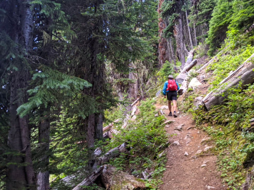
Switchbacks to heaven
While switchbacks can be tough on the calves, they do get the job done. 300m elevation over 1.4km is gained with these seven switchbacks. Personally, I liked being able to count them, tallying how many were left.
The third switchback is the longest but also marks the start of peek through mountain views. By the time you reach the top, there are huge glaciers visible over the trees.
The path then (thankfully) levels out as it heads towards the Monica Meadows campground. Along the way, wooden beams provide safe passage over a stream.

Exploring the meadows
The campground (2.4km) is basic but pleasant, recently added to allow sustainable overnight camping.
Just around the corner is the first meadow, scattered with wildflowers and backdropped by imposing mountains. Further on, a babbling brook winds through the lush greenery, lined by larch trees.
More boardwalks appear to help reduce damage to these delicate meadows.

Lake country
Veering slightly away from the stream, the trail begins a gentle ascent. Looking back reveals momentous views of the Horseshoe Glacier.

On arrival at a second and broader meadow, a faint trail leads to the right towards a series of small lakes.
We took it and enjoyed a snack break in front of the perfect alpine view of a reflective lake, backdropped by endless larch trees and line of imposing peaks named after Egyptian gods. More indistinct trails lead from here.

Finding paradise on the ridge
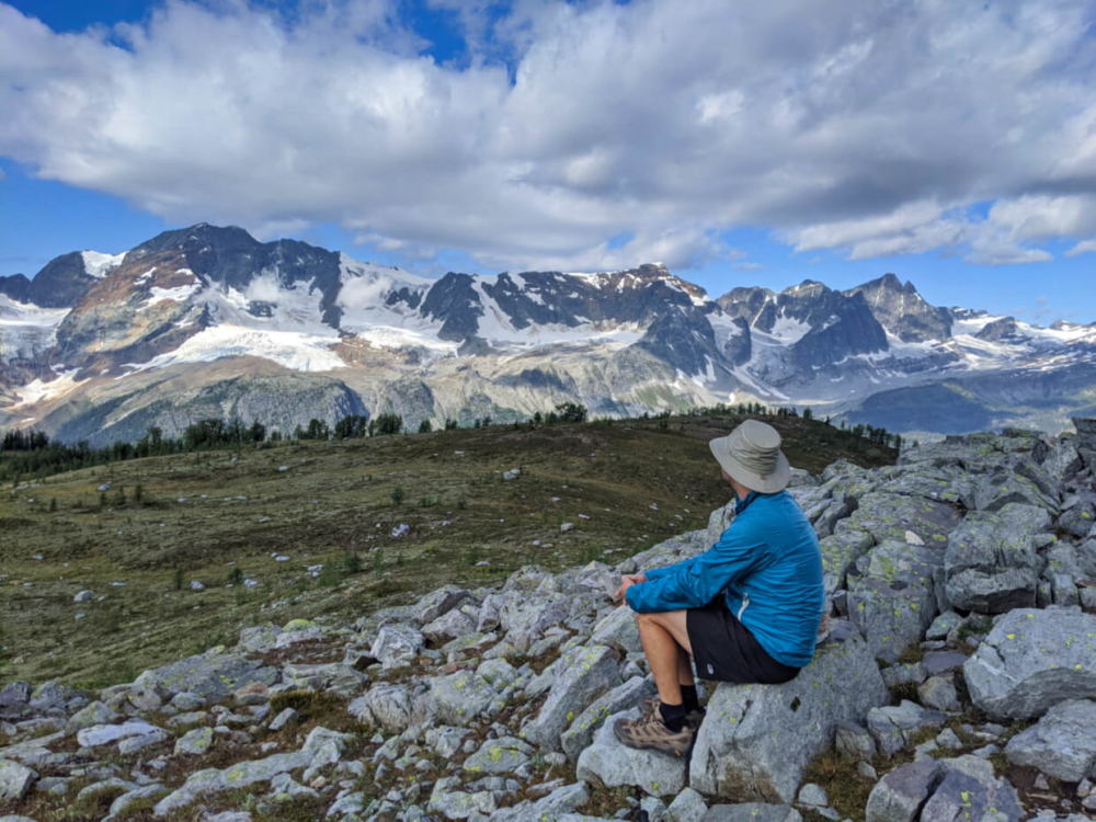
Returning to the main trail, it begins a steady ascent to a ridge. The views behind get better and better but are still completely eclipsed when you reach the ridgeline itself (4.3km).
Here, the world seems to drop away to reveal magnificent panoramas as far as the eye can see. The Macbeth Icefield sits directly opposite, displaying plentiful glaciers and snow capped peaks.
On both sides, Horseshoe Glacier and Starbird Glacier vie for attention. Mt Amon-Ra, Osiris and many others loom behind (spot the natural arch!), to complete the full 360 degree experience.
Anywhere else, these mountains would be the star attraction in their own right.
It’s a truly breathtaking sight, one that deserves time to take in. Truth be told, you could possibly sit here for hours and still be in wonder. This is a place that makes you feel insignificant.
A reluctant retreat
Arriving shortly after 8am, we had the place to ourselves and were happy to linger for a long time. Honestly, it was hard to draw ourselves away.
Fortunately, leaving doesn’t mean the views disappear straight away. The trail continues along the ridge for a while before descending slowly back to the second meadow to complete a circuit.
Returning to the first meadow is a pleasure, offering another chance to admire the vibrant wildflowers and trickling stream before leaving.
Just as they allowed for quick access to this alpine wonderland, the switchbacks make for a quick exit too. It almost feels over too soon. But the memories will stick for a long, long time.

Monica Meadows Hiking Guide
Inspired to check out Monica Meadows yourself? Read on to discover everything you need to know about this spectacular hiking trail in BC’s Purcell Mountains.

When to hike Monica Meadows
The best time to hike Monica Meadows is from late July to early October. Being at 2200m elevation, snow can linger late in the meadows. Glacier Creek FSR is also vulnerable to avalanche debris and this can take some time to clear.
The meadows are blanketed with an impressive display of wildflowers in midsummer. Though it depends on the year, early August is a good bet.
In early autumn, the larch trees at Monica Meadows offer an incredible blaze of colour. This usually happens around late September, with the peak colours on display for around 10 days.
Cold temperatures and snow comes early here, though ‘winter’ conditions are possible at any time of year. Our visit during the third week of August featured overnight temperatures close to freezing.

How to access the Monica Meadows trailhead
Monica Meadows is located in the Purcell Mountains, British Columbia. The closest community is Kaslo.
- From Kaslo, head north on Highway 31 to Lardeau and Trout Lake. 35km from Kaslo turn right onto Argenta Road. The surface quickly turns to gravel. The road is wide, well-used and generally easy to drive
- Continue following Argenta Road. After passing Glacier Creek Regional Park, look out for a right hand turn marked ‘Glacier Forest Service Road’ (12km from Highway 31). There are signs for Macbeth Icefields, Jumbo Pass and Monica Meadows
- Follow Glacier Creek for 24km. The road is narrow but fairly flat and reasonably well maintained. Expect occasional debris on the road
- At the junction, turn left for Monica Meadows (right goes to Jumbo Pass). The condition of the road is noticeably rougher here
- Continue for 1.5km and then turn right at the next junction
- The final 3.5km to the trailhead parking lot features a number of steep switchbacks. The road surface is rockier too and has deep water bars. If needed, you could park and then hike up to the trailhead but it would add quite a lot of elevation
High clearance is highly recommended for the drive to Monica Meadows, especially for the last 5km. Be prepared to drive slowly and expect the journey to take longer than anticipated. Though less than 42km from Highway 31, it took us just almost two hours to reach the trailhead

Navigating the trail
Monica Meadows has an established 10km return trail. It is balloon shaped, in that the start and end of the trail is the same but features a loop in the middle section.
From the parking lot, up the switchbacks, to the campground and through the meadow, the path is clear and fairly easy to follow. The route then leads up to a ridge viewpoint and then along the ridge itself before winding down to connect with the trail again.
This latter section is less defined. Monica Meadows’ alpine landscape is exceptionally delicate and hiking off-trail can permanently damage it. If you lose the trail:
- Consider retracing your steps first
- Step on rocks, dirt or gravel to cause minimal harm
- If none of the above options are available, choose leafy flowery plants
- Avoid woody plants such as heather – this causes long lasting damage
We usually use Maps.me for trail navigation but only a partial section (from the parking lot along the ridge) is featured. Be also aware that the default route shown on AllTrails shows a larger loop than the established trail.

Trail hazards
- Navigation. As mentioned above, some sections of the Monica Meadows trail are quite faint. Be careful to stay on the established route wherever possible to avoid damaging the delicate alpine landscape
- Bears. This area is grizzly bear territory so be sure to stay alert at all times. Make noise to make your presence known to any bears in the area. If camping, use the bear cache to store all food and smelly items
- Communication. There is zero phone service after turning off Highway 31. Tell someone where you’re going and when you plan to be back. Some hikers like to use satellite communication devices like Inreach or Spot to stay in continual contact

Camping at Monica Meadows
There is a basic backcountry campground at Monica Meadows, 2.6km from the trailhead. It is set into a group of trees, with partial views of mountains and glaciers. The facilities are rustic:
- Throne toilet (no sides or roof)
- Metal bear cache
- Fire ring (check for local fire bans before leaving)
- Flat spots for tents
We camped in our van in the parking lot, allowing us to get a very early start (6am!) on the trail. There’s an outhouse, as well as a wooden picnic table and fire ring.
There are no camping fees required for the backcountry campground or parking lot.
An alternative option for camping is Glacier Creek Regional Park on Argenta Road (11km from Highway 31). Located on a peninsula on Duncan Lake, this forested campground is only $15/night. Some of the sites even have lake views. It’s popular with ATV users.

Essential items to bring
- Bear spray – Bringing bear spray is a must when hiking the Monica Meadows Trail. Be sure to store it somewhere handy using a holster
- The 10 Essentials: Situations that would usually be slight inconveniences elsewhere (changes in weather, injuries, other unexpected events) can easily turn into life-threatening emergencies in the backcountry. Never forget to bring the 10 Essentials when exploring BC’s backcountry
- Hiking poles – I found it helpful to have hiking poles on this trail, using one to assist on the descent back down to the parking lot. Incredibly light and foldable, Black Diamond’s Carbon Z poles are my tried and tested favourite pair
- Toilet paper – There is a basic throne toilet at the Monica Meadows campsite and an outhouse in the parking lot. You’ll need to bring you own toilet paper and hand sanitizer


You may find these other posts helpful:
Hiking to Jumbo Pass near Kaslo, British Columbia
A Complete Adventure Guide to Valhalla Provincial Park
Burgess Shale Fossil Hunting in Walcott Quarry, Yoho National Park
18 Must Do Revelstoke Attractions and Activities
Climbing the Via Ferrata at Kicking Horse Mountain Resort, British Columbia
5 Awesome Alternatives to Banff, Alberta


One half of the Canadian/British couple behind Off Track Travel, Gemma is happiest when hiking on the trail or planning the next big travel adventure. JR and Gemma are currently based in the beautiful Okanagan Valley, British Columbia, Canada. Consider buying us a coffee if you have find any of our guides helpful!