North of Campbell River, Vancouver Island becomes a much wilder place to explore. The towns are smaller, the landscapes more rugged, and the connection to nature feels more profound. There are fewer tourists too.
A Campbell River to Port Hardy road trip is the best starting point for an unforgettable North Vancouver Island adventure.

As you travel northward and move away from the coast, the highway is enveloped by dense forest that conceals the tranquil lakes, mountain peaks and cave systems that lie just beyond.
Eventually, the road returns to the ocean, unlocking access to a range of exciting nature-focused activities such as whale watching, kayaking and hiking.

Outdoor recreation isn’t the only draw of this road trip; visitors can also discover remote coastal communities and First Nation culture.
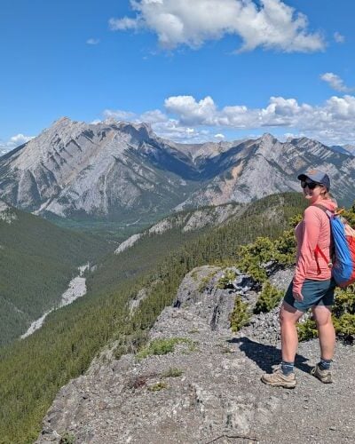
North Vancouver Island is truly one of my happy places in British Columbia. Previously living in Courtenay, we used to spend almost all of our free time exploring beyond Campbell River.
I’ve always loved the remoteness and the vast, seemingly boundless wilderness.

We revisited many of these locations in August 2024, while visiting the area to hike the North Coast Trail in Cape Scott Provincial Park.
In this post, I’ll share our favourite places to stop on a Campbell River to Port Hardy road trip with useful tips to help you make the most of the journey.
Here’s what to expect:
- Campbell River to Port Hardy road trip: Essential details
- Best places to stop
- Where to stay on a Campbell River to Port Hardy road trip
There are affiliate links in this post. If you make a purchase via one of these links, we may receive a small percentage of the sale.

Planning a trip to Vancouver Island?

Our Vancouver Island Travel Guide features an interactive map with 150+ of the best things to see and do.
The itinerary builder tool makes it easy to create your perfect trip.
Download the app and use offline while travelling!

Campbell River to Port Hardy road trip: Essential details
Before we dive into the top recommendations for must-see places between Campbell River and Port Hardy, I’m going to share some background about the road trip route.
If you’re familiar with the area and just looking for ideas of where to go, feel free to skip ahead.
The driving distance between Campbell River and Port Hardy is 233km.
Most people drive this distance in one day. The most straightforward journey (without stops) takes around 2 hours 30 minutes.
With so many enticing spots along the route, however, you’ll want to stop at least a few times.
This Campbell River to Port Hardy road trip route travels across the traditional territory of multiple First Nations, including the We Wai Kai, We Wai Kum, K’ómoks, Liǧʷiłdax̌ʷ, Kwakwaka’wakw A̱wi’nagwis, Nuu-chah-nulth and Quatsino.
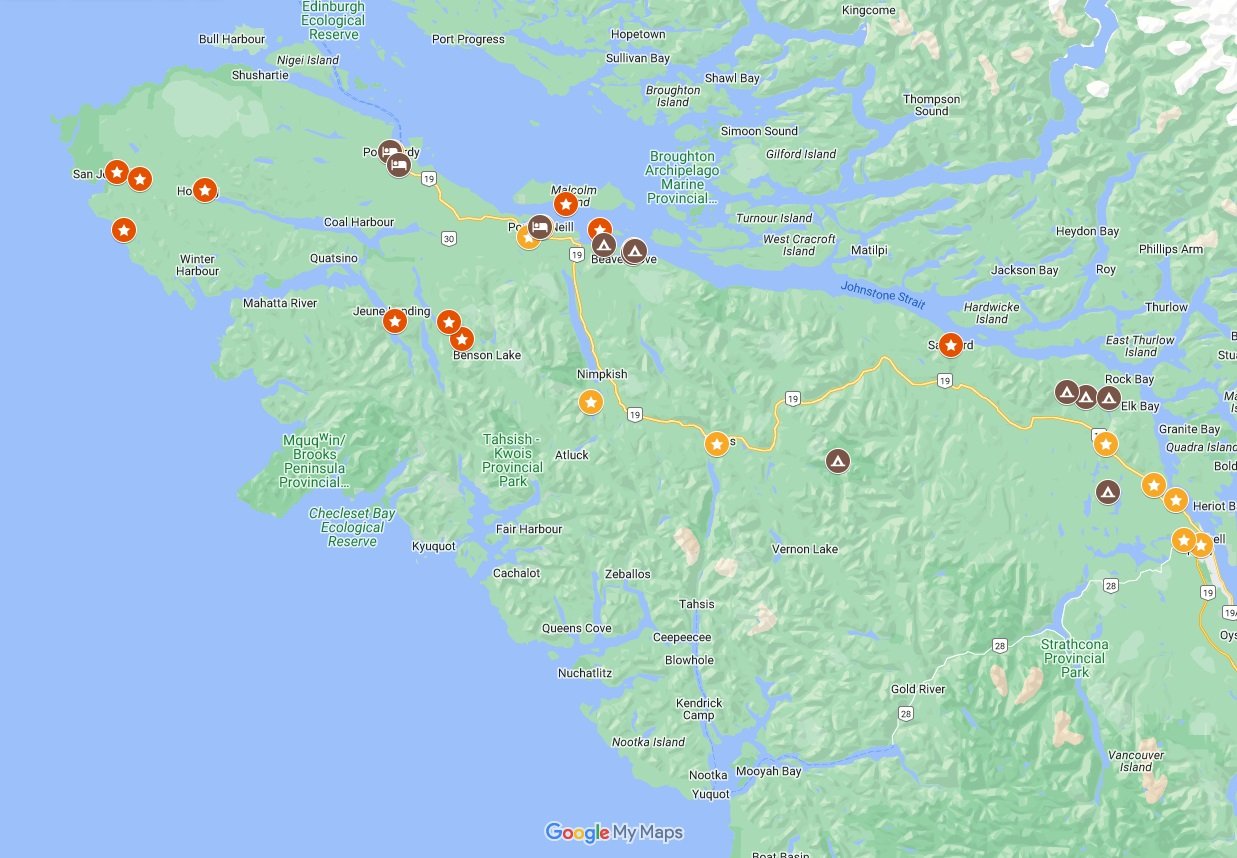
Campbell River to Port Hardy road trip map
How to reach Campbell River
Campbell River is Vancouver Island’s most northern city, 260km from Victoria (3 hours drive) and 150km (90 minutes) from Nanaimo.
Most visitors to Campbell River arrive by road from the south, via Highway 19 or the coastal equivalent, Highway 19A.

Driving to Campbell River from Nanaimo? Don’t miss our road trip guide featuring all of the best things to do between Campbell River and Nanaimo.
The closest mainland ferry route to Campbell River is Departure Bay in Nanaimo. Ferries arrive here from Horseshoe Bay (West Vancouver). Additional services are available to Duke Point in Nanaimo from Tsawwassen (south of Vancouver).
While Campbell River does host a BC Ferries terminal, it only services nearby Quadra Island (twice-hourly departures, 15 minute sailing). From Quadra, it is possible to take another ferry to Cortes Island (six sailings a day, 45 minutes long).

Driving between Campbell River to Port Hardy: what to expect
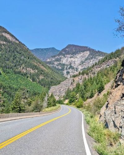
There is one paved road between Campbell River and Port Hardy – Highway 19. For the majority of the route, it is an undivided two-lane highway, with one lane in each direction.
While Highway 19 is frequently travelled, I would not say it is a busy road. Before you start your journey, check DriveBC for possible closures and construction.
With only a few passing areas, plan for a slightly slower journey than you may expect. This part of Highway 19 is frequented by significant industrial traffic, including large logging trucks.
By Canadian standards, Highway 19 is a fairly uncomplicated drive. There are a few long-ish uphill/downhill sections, but nothing steep with no switchbacks or cliff edges. It is certainly not a straight road, however, so expect plenty of curves.

The access roads to the communities of Sayward, Woss, Telegraph Cove, Port Hardy, Port McNeill and Port Alice are all paved.
Expect all other side roads to be unpaved. The road network surrounding Highway 19 was primarily built for industrial traffic. Some of these roads are better maintained than others. A high-clearance vehicle is preferable.
Please note that the majority of rental companies will not allow you to drive on unpaved roads. FarOut Wilderness is one of the few that does. Contact FarOut with the code FOW-OTT-5 for a 10% booking discount.
When driving on industrial roads, be prepared to meet loaded logging trucks and other large vehicles at any time. Slow down and give way. I would recommend a Vancouver Island Backroad Mapbook for navigation.
Good to know
- The speed limit on Highway 19 between Campbell River and Port Hardy varies between 90km/h to 100km/h
- Phone signal is intermittent along this route. In our experience, we always lose consistent signal just north of Campbell River and only receive spotty connections thereafter (except in towns)
- For the above reason, be sure to tell someone where you are going and when you plan to be back or check in with them again
- Wild animals can be present on the road at any time but particularly during dawn and dusk. North Vancouver Island is home to a large population of Roosevelt Elk, cougar and black bear
- As mentioned, the northern part of Vancouver Island is quite wild and remote. Be sure to bring everything you need with you and Leave No Trace while exploring

Public transportation
Curious whether you can take the bus between Campbell River and Port Hardy?
As of May 2024, the Island Link Bus provides regular services between Campbell River, Port Hardy and Port McNeill as well as several other North Island communities. Connections will be available to other Island locations.
Campbell River to Port Hardy road trip: Best places to stop
Read on to discover our top picks for places to visit on a Campbell River to Port Hardy drive.
I would suggest 3 to 4 stops in each direction, assuming you are staying at least one night in Port Hardy and returning to Campbell River. This would add 2 to 4 hours to your journey.
Certain activities require extra time. Whale-watching tours from Telegraph Cove take up half a day, for example.
If you choose to extend your trip beyond Port Hardy to Cape Scott or Sointula/Alert Bay, I would plan for at least two extra nights.
Elk Falls Provincial Park
Before leaving the Campbell River area, take a detour to Elk Falls Provincial Park.
The star attraction is the 25m high waterfall cascading from the top of a deep canyon. Walk the (free!) suspension bridge across the gorge for the most breathtaking views.

Elk Falls is the most accessible hiking destination on this Campbell River to Port Hardy road trip guide. The trail to the first viewpoint is short (800m, about 15 minutes), mostly flat and wheelchair/stroller friendly.
The suspension bridge is located down some stairs, with another viewpoint 600m further up the trail (10 minutes). Visitors looking for a longer hike can continue to other trails, including a 2-3 hour circular route.
Distance from Campbell River: 5km
Distance from Port Hardy: 237km
Suggested time: 45 minutes to 1 hour

Ripple Rock Trail or Lookout
Ripple Rock is an underwater mountain in the narrows between Vancouver Island and Quadra Island. A marine hazard for decades, it was partially destroyed in 1958 in one of the largest non-nuclear planned explosions ever.
While there is a Ripple Rock lookout right on the highway, you can get a much better view from the Ripple Rock Trail.
This 4km one-way trail has several scenic ocean viewpoints on the way to the final lookout over the site of the explosion.
Distance from Campbell River: 17km / 13km
Distance from Port Hardy: 217km / 221km
Suggested time: 5 minutes for lookout, 3 hours for the 8km hike

Roberts Lake
Looking for somewhere to take a quick break from the road or have a picnic? Head to Roberts Lake, about 20 minutes north of Campbell River.
This pretty lake hosts a roadside Rest Area, but I would suggest going to the Recreation Site at the south end instead. While the access road is unpaved and the drive will take a few minutes longer, it is worth the extra effort.
From the parking area, walk 200m along the wheelchair-accessible flat path to the lake. The shoreline features a sandy beach, a floating dock and picnic tables.
Distance from Campbell River: 31km
Distance from Port Hardy: 204km
Suggested time: 15 to 45 minutes

Dalrymple Creek
Dalrymple Creek is an 1km loop trail through an old growth forest. It’s an easy hike, suitable for all ages. There are interesting interpretive signs along the route, provided by Mosaic (a local logging company).
Besides the very tall trees, another highlight is soothing Dalrymple Creek itself. It features several small waterfalls.
The Dalrymple Creek trailhead is located just off Highway 19, about five minutes drive south of the Sayward junction. There are several worn picnic tables in the parking lot but no outhouse.

Side trip – Sayward
Consider a detour to Sayward, a small village set between ocean and rugged forest. This is the only paved road access to Johnstone Strait until Telegraph Cove.
While the community may be tiny (around 350 people), Sayward is a surprisingly busy place. There is a lot of marine traffic on the Strait and also in the waterfront area, with brightly coloured boom boats moving around the log sort area.
The short Salmon River Estuary Walk (1.3km return) is a good option for a quick visit. It features some lovely viewpoints of the water and surrounding mountains.
If you feel like spending the night, there is a municipal campground as well as some private campgrounds.
As a side note, we always seem to see elk herds around the turn-off for Sayward. Be sure to keep your eyes peeled!
Distance from Campbell River: 75km
Distance from Port Hardy: 180km

Woss Heritage Park
Even smaller than Sayward is the community of Woss (population of 200), which lies in the Nimpkish Valley. Until 2017, Woss was the headquarters of the Englewood Railway, the last operating logging railroad in all of North America.
To commemorate this historic railway, Western Forest Products’ Steam Locomotive #113 now sits in the Woss Heritage Park. There is a kiosk with interpretive signage, washrooms and picnic tables as well.
Logging is still a major employer in Woss and many other North Vancouver Island communities but the logs are now transported by road on logging trucks.
This quick Campbell River to Port Hardy road trip stop provides valuable insight into the region’s primary industry. Before heading back to Highway 19, take a quick drive on Railway Ave over the roaring river.
Distance from Campbell River: 130km
Distance from Port Hardy: 105km
Suggested time: 15 to 30 minutes

Little Huson Caves Regional Park
In my opinion, Little Huson Caves is a must-stop for nature lovers when driving between Campbell River and Port Hardy. It’s one of the most accessible cave systems on the Island.
Little Huson Caves showcases numerous beautiful limestone karst formations, including a large cathedral-like river cave, a natural rock bridge, sinkholes and a surfing wave wall. An easy 500m trail leads to the main viewing area.
Little Huson Caves is located around 10km from Highway 19. Access is via unpaved roads only. For navigation, I’d recommend referring to the Vancouver Island Backroad Mapbook.
The road condition is usually decent enough for most 2WD vehicles, as long as you drive slowly and carefully. The final section (2.5km) can be a little bumpy. Allow at least 20 minutes for the one-way drive.
Distance from Campbell River: 160km
Distance from Port Hardy: 92km
Suggested time: 2 hours with driving detour

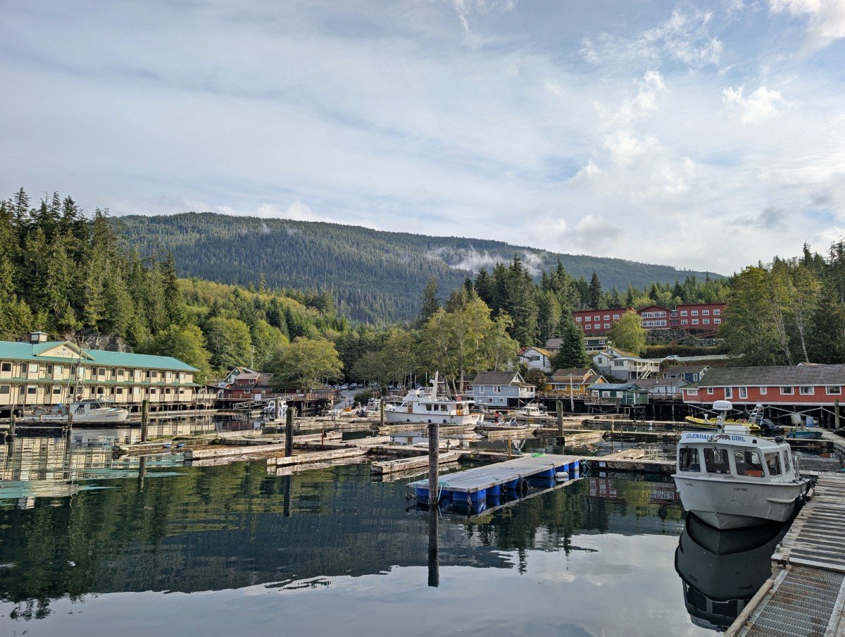
Telegraph Cove
Telegraph Cove is the most colourful community anywhere on North Vancouver Island. This former fishing and cannery village features brightly painted heritage buildings on stilts, connected by a wooden boardwalk.
Today, Telegraph Cove has only 20 year-round residents. In the warmer months, however, it transforms into a busy eco-tourist resort (parking can be tricky!)
The adjacent Johnstone Strait is home to one of the largest resident pod of orcas in the world. Telegraph Cove is a popular departure point for wildlife watching tours (for whales and also bears) and guided kayak adventures (both day trips and multi-day).
We joined a grizzly bear watching tour from Telegraph Cove in late September 2025 and it was a truly bucket list worthy experience! We saw three grizzly bears plus many more black bears, humpbacks and minke whales.
***A small part of Telegraph Cove was destroyed by fire on 31st December 2024. The Whale Centre was unfortunately lost but guided wildlife tours continue, as do accommodation operations. The General Store is serving coffee and hot food for lunch and dinner.***
Distance from Campbell River: 201km
Distance from Port Hardy: 64km
Suggested time: 1 hour (more if you plan to join a whale-watching tour)
Port McNeill
As well as being the first town after Campbell River, Port McNeill is the jumping-off point for trips to Malcolm Island (Sointula) and Cormorant Island (Alert Bay).
Originally a base camp for loggers, Port McNeill officially became a settlement in the mid-1930s. It takes around two hours to drive from Campbell River to Port McNeill without any stops.
Port McNeill’s waterfront offers expansive ocean and marina panoramas. Enjoy a craft beer or two with the view at the locally-owned brewery, Devil’s Bath. The pizza menu is pretty great too (and yep, the brewery has a sunny patio!)
Distance from Campbell River: 195 km
Distance from Port Hardy: 43km

World’s Largest Burl
Somewhat confusingly, Port McNeill is host to two ‘World’s Largest Burl‘ sites. A tree burl is an abnormal swelling of wood usually found on bark or branches.
The largest preserved tree burl was found on a 500-year-old Sitka Spruce tree near Holberg in 2005. It now sits near Port McNeill’s waterfront.
Unfortunately, the 30-tonne and 6m wide ‘Ronning Burl’ was accidently set alight in May 2023. While still available to view now, the display is sadly not what it was.
Before that discovery, the record was held by another locally sourced Sitka Spruce tree burl.
The weight of this ‘runner-up’ burl is estimated at 20 tonnes and has a similar circumference as the current record holder. It is displayed just off Highway 19, 5 minutes drive from Port McNeill.
Distance from Campbell River: 196km / 195km
Distance from Port Hardy: 43km / 37km
Suggested time: 15 minutes

Side trip – Alert Bay / ‘Yalis
Alert Bay is a community on Cormorant Island (total pop. 1,300). It is also known as ‘Yalis.
The area is rich in First Nation culture as well as natural beauty and wildlife sightings. Alert Bay is a 45-minute ferry ride from Port McNeill and well worth a day trip or overnight stay.
Located on traditional Kwakwaka’wakw territory, about half of Cormorant Island residents are part of the ‘Namgis First Nation.
The world’s largest totem pole is situated in Alert Bay. 52m high, the wooden pole depicts several different Kwakwaka’wakw groups (rather than a single-family).

Another must-see in Alert Bay is the U’mista Cultural Centre. The main exhibit displays potlatch items that were originally confiscated by the Government of Canada in 1921. The Kwakwaka’wakw people fought to have these sacred items returned from institutions around the world.
Alert Bay is also known as the ‘Home of the Orca.’ Whale-watching tours depart up to twice daily during the peak season (mid July to mid September)
To this day, Alert Bay remains one of the friendliest places I have ever visited. Read our full travel guide for more details!
Distance from Campbell River: 195km + ferry
Distance from Port Hardy: 44km + ferry

Side trip – Sointula, Malcolm Island
Another day trip or overnight destination near Port McNeill is Malcolm Island, also on traditional Kwakwaka’wakw territory. It is accessed via a 25-minute ferry ride from Port McNeill.
Sointula is the main village and home to around 600 full-time residents. Originally established as a utopian colony in the early 1900s, the community’s name means ‘place of harmony’ in Finnish.
With this history in mind, Sointula is home to the oldest continuously running co-op in Canada. The Sointula Co-op Store (opened in 1909!) is well worth a visit.
Other attractions in Sointula include art galleries, artisan studios and a museum. If you bring your vehicle, drive out to Bere Point Regional Park for the chance to see orcas on the rubbing beach (there’s an amazing campground here too).
Distance from Campbell River: 195km + ferry
Distance from Port Hardy: 44km + ferry

Port Hardy
The town of Port Hardy is Vancouver Island’s ‘end of the road.’ Well, at least the paved road! Highway 19 finishes on the picturesque waterfront of this service town.
Port Hardy is surrounded by wilderness and is a great place to get away from it all. Multiple operators run wildlife-watching tours, offering the chance to see orcas, sea otters and more.
Most travellers finish their trip at Port Hardy, returning to Campbell River the way they came. Another option is to catch the 16-hour ferry up the Inland Passage to Prince Rupert or Haida Gwaii.
Adventurous visitors with little more time on their hands may use Port Hardy as a launching point to explore beyond-the-beaten-path destinations such as Port Alice, Cape Scott Provincial Park and Raft Cove. The North Coast Trail water taxi service leaves from Port Hardy.
Distance from Campbell River: 233km

Side trip – Holberg, Cape Scott Provincial Park and Raft Cove
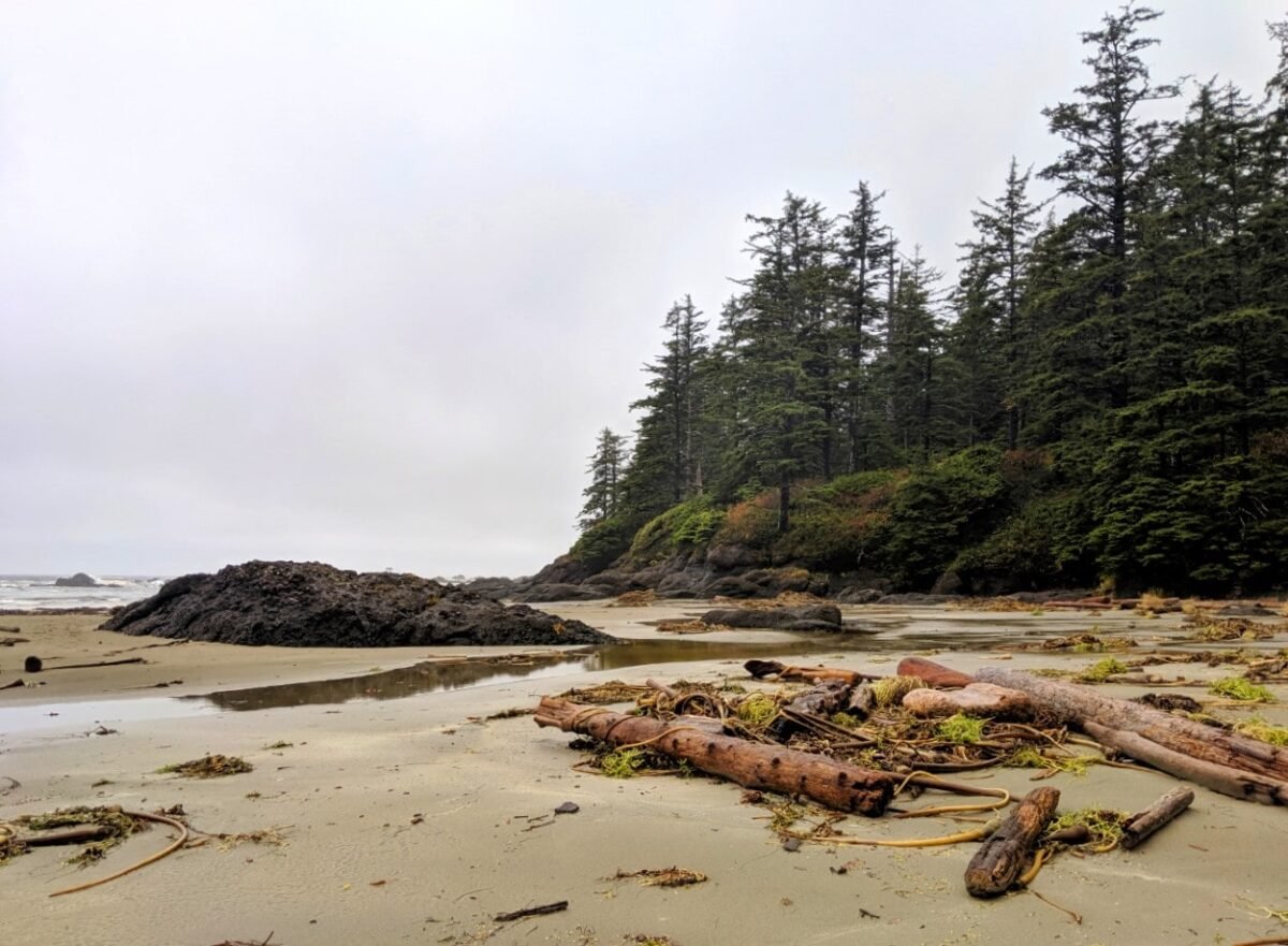
Cape Scott is the northwestern tip of Vancouver Island, situated in a remote provincial park of the same name that protects pristine golden sand beaches, old-growth forest groves, sea stacks and more.
Walk the flat 2.5km trail (45 minutes) to San Josef Bay or backpack overnight to Nels Bight and the Cape Scott Lighthouse.

The drive from Port Hardy to Cape Scott is 65km but takes around two hours. It is unpaved and includes some private logging roads. Though the route is well-travelled, it is still remote. This is not a journey to take lightly.
Bring a reliable vehicle and prepare to be self-sufficient (water, food, extra clothing). Check your spare tire and know how to change it. The condition of the road can be pretty variable, especially after rain. It can get pretty bumpy.

The logging camp of Holberg (pop. 200) is the only community along the route and services are very limited, besides a General Store and the welcoming (and wonderful) Scarlet Ibis Pub.
Ronning’s Garden is not far from the entrance of Cape Scott, the site of an early 20th-century homestead featuring an eclectic mix of plants and trees.
More hiking opportunities await in Raft Cove Provincial Park. The main trail is 2km long and is exceptionally muddy and rooty. The reward is a gorgeous, long windswept white sand beach. Walk-in camping is $5/night/per person
Distance from Campbell River: 297km
Distance from Port Hardy: 69km
Suggested time: Overnight
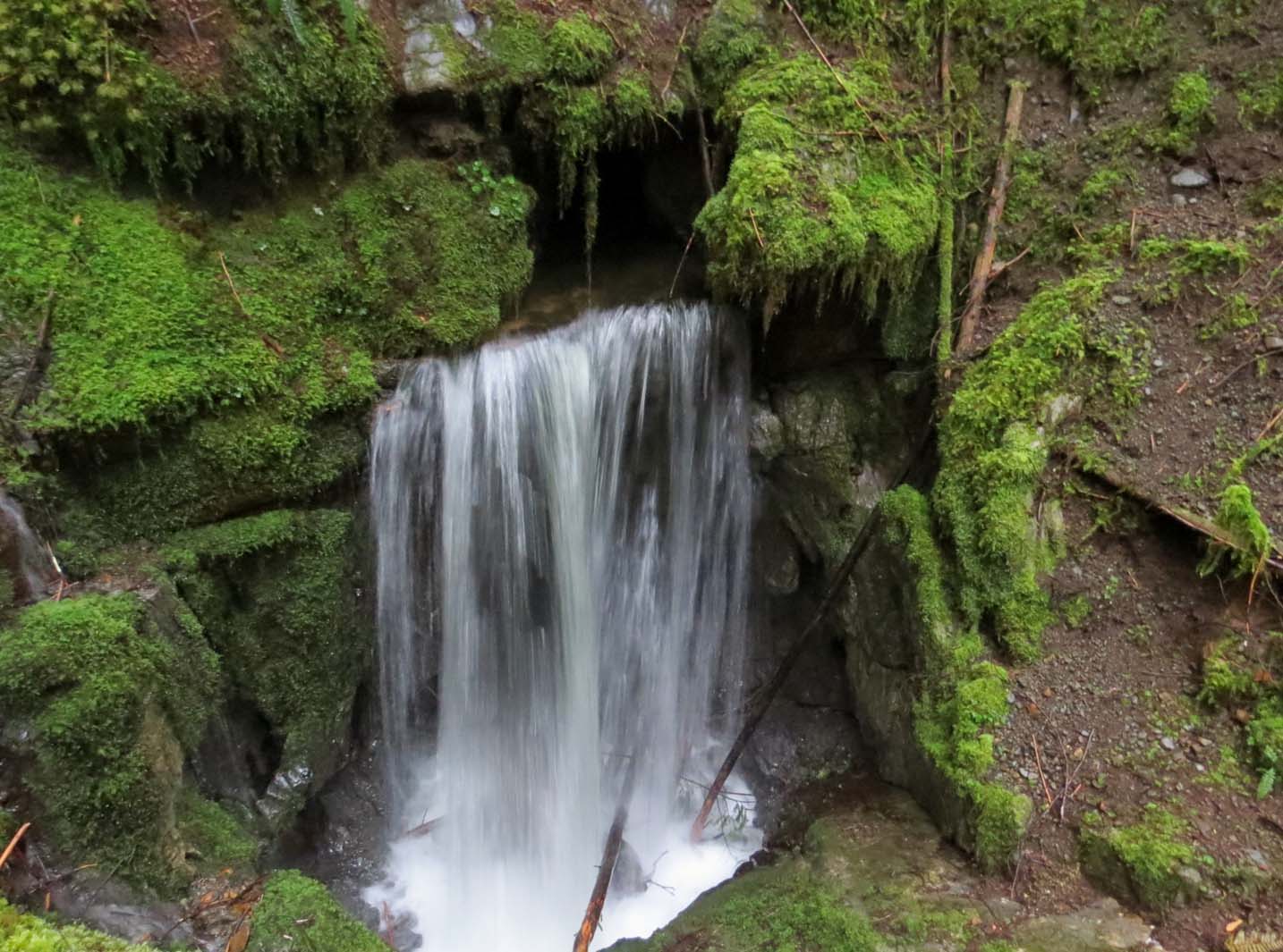
Side trip – Port Alice, Devil’s Bath and Eternal Fountain
If you’ve still got time, consider a side trip to Port Alice before returning to Campbell River.
The village of Port Alice (pop. 740) is situated on the beautiful Neroutsos Inlet. There is paved road access via the scenic Highway 30, which connects to Highway 19 roughly halfway between Port McNeill and Port Hardy.
Once in town, take a stroll on the Port Alice Seawalk and enjoy the gorgeous ocean views. This growing community has an excellent new coffee shop, Foggy Mountain Coffee Co.
Port Alice is a popular fishing and camping destination. Many people also pass through to visit the nearby collection of geological oddities on the unpaved Alice Lake Loop, namely the Devil’s Bath (Canada’s only cenote!) and the Eternal Fountain (a waterfall that flows into a cave).
Distance from Campbell River: 243km
Distance from Port Hardy: 52km
Suggested time: 3-4 hours
Best places to stay on a Campbell River to Port Hardy road trip
Our favourite place to stay in Campbell River is the Above Tide Motel. While the rooms are not luxurious, the oceanside location of this property is incredible and the prices are pretty reasonable. Each room has a balcony with uninterrupted views of the Salish Sea.
In Port McNeill, the Humpback Inn is highly rated. It is situated on Beach Drive, just across from the ocean. The ferry terminal to Alert Bay and Sointula is within walking distance.
Port Hardy has the best choice of accommodation in the North Vancouver Island region. One of the more unique options is the Kwa’lilas Hotel (meaning ‘a place to sleep’).
Built, owned and operated by local Gwa’sala-‘Nakwaxda’xw People, the high-end rooms are decorated with Indigenous art. The on-site restaurant serves tasty Indigenous-inspired West Coast cuisine.

The Quarterdeck Inn is a good alternative for a comfortable night in Port Hardy. Some of the rooms have ocean views. For something a little more private, consider the Port Hardy Cabins. These well-kept log cabins are conveniently located as well as cosy.
Heading up to Cape Scott? The Adventure Huts in Holberg are an ideal pick for a post-hike stay. These small handcrafted cabins are on the basic side but have everything you need after some time in the backcountry (including access to a shower!)
With North Vancouver Island being relatively remote, I would highly recommend reserving accommodation in advance.

Camping options
There are SO many great places to camp on North Vancouver Island! This is particularly true if you have a vehicle suitable for driving unpaved backroads and/or backcountry gear (for multi-day paddling/hiking trips).
The Sayward Forest, northwest of Campbell River, hosts an incredible number of lakeside Recreation Site campgrounds (unpaved access only, limited services). Many are free.
There is another collection of lake-adjacent campgrounds just a little further along Highway 19. Pye Lake, Stella Lake and McCreight Lake each have a choice of free campsites. Again, unpaved road access only.

Schoen Lake is the only frontcountry provincial park campground along the Campbell River to Port Hardy drive, though the access is on an unpaved road. There are 9 campsites set in an old-growth tree grove, with some enjoying lake views.
More free Recreation Site campsites can be found on the shores of Woss Lake, Nimpkish Lake, Atluck Lake, Bonanza Lake, Nahwitti Lake, Alice Lake and Victoria Lake. There is a paved road access campground at Marble River.

For serviced campsites (electricity, water, flush toilets, showers etc), head to Telegraph Cove or Alder Bay. The latter has a waterfront RV campground with over 80 campsites. It’s a good option for tent campers too, with 12 walk-in (tent) only sites located right on the water.
Backpacking opportunities are numerous in Cape Scott Provincial Park and Raft Cove Provincial Park. There are also many marine campsites in this area, from God’s Pocket, the Broughton Archipelago, the Brooks Peninsula and Johnstone Strait.

Other resources you may find helpful to plan your road trip
Where to Find Big Trees on Vancouver Island
San Josef Bay, Vancouver Island: Hiking and Camping Guide
25+ Amazing Vancouver Island Waterfalls You Must Visit
22+ of the Best Campgrounds on Vancouver Island, BC
Nanaimo to Tofino Road Trip Guide: 15 Amazing Places to Stop
Check out these recently published articles next


One half of the Canadian/British couple behind Off Track Travel, Gemma is happiest when hiking on the trail or planning the next big travel adventure. JR and Gemma are currently based in the beautiful Okanagan Valley, British Columbia, Canada. Consider buying us a coffee if you have find any of our guides helpful!
Awesome! SO super helpful
Aw thank you so much!
Great guide , when in port hardy go visit the museum in Coal Harbour
Thank you Milo!