Searching for a Vancouver Island adventure further away from the beaten path? Consider a Nanaimo to Campbell River road trip.
This coastal adventure offers the chance to stroll along spectacular sandy beaches, take in dramatic waterfalls, eat local seafood and hike through the temperate rainforest. Keep your eyes peeled, there’s a chance to see orca whales too.
Choose (or alternate) between two highways, one closely following the scenic shoreline. Stay overnight in coastal communities and enjoy colourful sunsets, mountain views and salty sea air.

Central Vancouver Island is a place we love and know well. Previously living in Courtenay, we still visit this area at least once (often twice) a year. Needless to say, we’ve driven from Nanaimo to Campbell River many, many times.
In this post, I’ll share our favourite places to stop on a Nanaimo to Campbell River road trip as well as useful tips to make the most of the journey.
Here’s what to expect:
- Nanaimo to Campbell River road trip: Essential details
- Best places to stop
- Petroglyph Park, Nanaimo
- The Abyss, Nanaimo
- Neck Point Park, Nanaimo
- Rathtrevor Beach Provincial Park
- Englishman River Falls Provincial Park
- Parksville Boardwalk
- Qualicum Beach
- Oceanside Route – Buckley Bay to Courtenay
- Royston Seaside Trail
- Downtown Courtenay
- Goose Spit Park
- Nymph Falls / Browns River Falls
- Miracle Beach / Saratoga Beach
- Oceanside Route – Oyster River to Campbell River
- Discovery Pier
- Elk Falls Provincial Park
- Where to stay on a Nanaimo to Campbell River road trip
There are affiliate links in this post. If you make a purchase via one of these links, we may receive a small percentage of the sale.

Planning a trip to Vancouver Island?

Our Vancouver Island Travel Guide features an interactive map with 150+ of the best things to see and do.
The itinerary builder tool makes it easy to create your perfect trip.
Download the app and use offline while travelling!

Nanaimo to Campbell River road trip: Essential details
Before we jump into my recommendations for the coolest places to check out between Nanaimo and Campbell River, I thought it’d be a good idea to share some background about the road trip route.
If you’re familiar with the area and just looking for ideas of where to go, feel free to skip ahead.
The driving distance between Nanaimo and Campbell River is 155km.
Most people drive this distance in one day. The most straightforward journey (without stops) takes around 90 minutes.

But with so many places to see along the route, you’ll definitely want to stop at least a few times!
When planning your journey, consider combining this adventure with a Nanaimo to Tofino road trip. Feeling adventurous? Continue beyond Campbell River to Port Hardy or across to the Sunshine Coast.
This Nanaimo to Campbell River road trip route travels across the traditional territory of multiple First Nations, including the K’ómoks, Homalco, Liǧʷiłdax̌ʷ, We Wai Kai, We Wai Kum, Snuneymuxw and Snaw-naw-as.
Nanaimo to Campbell River road trip map

How to reach Nanaimo
The start of this road trip route is the city of Nanaimo (pop 100k), situated on the eastern coast of Vancouver Island.
Hosting two ferry terminals, Nanaimo is a major arrival point for visitors to Vancouver Island.
Departure Bay is located just north of downtown Nanaimo, while Duke Point is 16km further south.
BC Ferries operates large drive-on ferries to these terminals from the Vancouver area on the mainland. These ferries take both foot passengers and vehicles.
If Vancouver Island is your main destination, consider renting a vehicle in Nanaimo rather than Vancouver. It’s much cheaper to cross as a foot passenger (without a vehicle) and a lot easier to secure a spot on board.
Of course, Nanaimo can also be reached by road. Nanaimo is 111km from Victoria, the capital city of British Columbia (1 hour 40 minutes driving time).

Driving between Nanaimo and Campbell River: what to expect
The fastest route from Nanaimo to Campbell River is via Highway 19. Road trippers have the option to drive Highway 19 in combination with Highway 19A.
Highway 19
Highway 19 provides the most straightforward drive between Nanaimo and Campbell River. The highway is double-lane (four lanes total), with divided lanes or a concrete barrier along most of the route.
The southern half is busier, with significant traffic around the residential areas of Nanaimo and Nanoose Bay. The majority of the two dozen traffic lights along the route are found near Nanaimo.
After the turn-offs to Tofino, Parksville and Qualicum Beach, the road becomes a lot less busy. The 128km stretch to Campbell River is also known as the ‘Inland Island Highway’ and avoids residential areas.
In my opinion, this part of Highway 19 is the easiest road to drive in BC. It is very flat, there are very few curves, traffic levels are low and there are no steep drop-offs.
Highway 19A
Highway 19A is a secondary highway set close to the Salish Sea, running roughly parallel to Highway 19 between Parksville and Campbell River.
Known as the ‘Oceanside Route’ or ‘Old Island Highway,’ this road was the original Highway 19 route until the 1990s.
For the most part, Highway 19A features only two lanes, with one in each direction. There are intermittent passing sections.
Good to know
- There are gas stations at regular intervals along Highway 19A. There are no gas stations or services located directly on the Inland Island Highway section of Highway 19
- Easily accessible from both Highway 19 and Highway 19A, the Buckley Bay Rest Area (the best on the route, in my opinion) has a large parking area as well as washrooms, picnic tables and EV chargers. There is a six-hour maximum stay limit
- The southern section of Highway 19 has a variable speed limit between 50km/h to 90km/h, with 110km/h being the standard along the Inland Island Highway (from Parksville to Campbell River)
- Travelling through many different residential areas and curving along the ocean, the speed limit on Highway 19A varies from 40km/h to 80km/h
- For this reason, Highway 19A is a much slower drive overall than Highway 19 (2 hours 30 minutes vs. 90 minutes)
Public transportation
Curious whether you can take the bus between Nanaimo and Campbell River? Yes, you can!
The Island Express Bus, operated by Island Link Bus, operates at least three times daily between Nanaimo (Departure Bay Terminal) and Campbell River. The service runs year-round, with more frequent daily departures during the summer months.
Travelling the coastal route (Highway 19A), the bus stops in communities such as Parksville, Qualicum Beach, Fanny Bay, Courtenay and Black Creek. It does not stop at any attractions or viewpoints along the way.
Taking the ferry to Departure Bay as a foot passenger? The Island Express Bus is scheduled to meet ferry arrivals (so convenient!)
Nanaimo to Campbell River road trip: Best places to stop
Read on to discover our top picks for places to visit on a Nanaimo to Campbell River drive. The following destinations are all within 15 minutes of the highway.
I would suggest 3 to 4 stops in each direction, assuming you are staying the night in Campbell River and returning to Nanaimo. This would add 2 to 4 hours to your journey.
Depending on how much time you have, I would recommend driving a combination of Highway 19 (faster, easier) and Highway 19A (slower, but more scenic).
Considering a longer visit in this area? There are SO many amazing things to do between Nanaimo and Campbell River; consider this list a highlights reel of roadside attractions.
I would recommend spending another night along the route, so you can visit more places. Parksville, Qualicum Beach and the Comox Valley are all great overnight destinations. Alternatively, two nights in Campbell River would work well too.

Petroglyph Provincial Park
This tiny park on the south side of Nanaimo has a remarkable collection of First Nation rock art carvings known as petroglyphs. Set into a sandstone gallery, the prehistoric carvings are located on a hill overlooking the city.
An interpretive area provides insight into the possible meaning of the petroglyphs and historical background. There are some concrete replica castings, which can be used for paper rubbings (bring your own supplies).
Keep in mind that Petroglyph Park has a small parking lot located right off Highway 1, and it can only be accessed when driving northbound.
Distance from (downtown) Nanaimo: 5km
Distance from Campbell River: 161km
Suggested time: 15 to 30 minutes

The Abyss
If you like unique activities, consider a hike to the Abyss. This is a slightly offbeat road trip suggestion but I have included it as I don’t know of any place like it anywhere else in BC!
The Abyss is an impressive 50cm wide fissure on a ridge above Nanaimo. It is unknown what caused the land to split in this way but some have suggested that it could be the result of a collapsed mine tunnel, triggered by an earthquake.
This interesting geological formation is found on the Extension Ridge Trail on the outskirts of Nanaimo (10-minutes drive southwest of downtown).
The 1km uphill hike is well-signed and passes through a beautiful grove of arbutus trees (as well as an ugly cut block).
If you are visiting the Abyss with a dog, please keep them on a tight leash. I’ve heard about dogs falling into the crack and having to be rescued by the fire department.
Distance from (downtown) Nanaimo: 5km
Distance from Campbell River: 158km
Suggested time: 45 minutes to 1 hour

Neck Point Park
In my opinion, Neck Point Park is the best place in the Nanaimo area for a family-friendly, scenic coastal walk. Newcastle Island (Saysutshun) is another good choice if you have more time.
Neck Point Park is a 36-acre protected waterfront area featuring rock cliffs, pebble beaches and rare Garry Oak forest. The namesake ‘neck’ is located at the tip of the park, consisting of a sandbar and rocky headland.
Walking trails crisscross the peninsula, with interpretive signage providing insight into the natural attractions and the park’s interesting history. This is a very popular place to scuba dive due to the rich sea life living below the headlands.
As mentioned, I would rate Neck Point Park as family friendly but be sure to keep young children close as there are some steep drop-offs.
Distance from Nanaimo: 11km
Distance from Campbell River: 149km
Suggested time: 30 minutes to 1 hour, depending on your desired route

Rathtrevor Beach Provincial Park
Rathtrevor Beach is a gorgeous 2km-long stretch of golden sand in Parksville. When the tide is out, it feels like you can walk for miles. The views seem to extend endlessly too, towards offshore islands and distant mountain ranges.
We’ve always been lucky to see a lot of wildlife here, spotting sea otters and deer on our last visit. Sunset seems to be a good time to visit and not just for the spectacular vistas!
With a huge amount of parking and relatively easy access from Highway 4, Rathtrevor is my top pick for a beach stop in this area.
There is an excellent 200+ site campground within this provincial park but you’ll have to reserve early if you want to secure a spot! It’s one of the most popular (and best) campgrounds on Vancouver Island.
Distance from Nanaimo: 34km
Distance from Campbell River: 127km
Suggested time: Around 1 hour

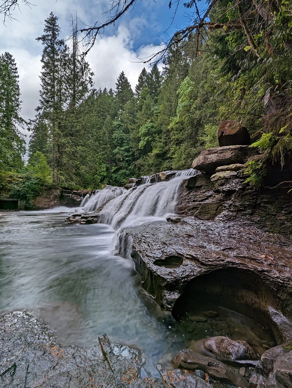
Englishman River Falls Provincial Park
This Nanaimo to Campbell River road trip stop requires a 30-minute round-trip detour from Highway 19. I assure you, however, that it is worth your time.
A short walk from the parking lot (300m!) reveals a breathtaking viewpoint of the Upper Englishman River Falls, where the river dramatically falls into a canyon. Mist rises above while the water roars below.
Return to the parking lot from here or complete a 1.7km loop route that also takes in the lower falls. There is a great view of the water plunging into a crystal clear pool as well as the algae-covered basin walls and overhanging trees.
Be careful not to get this park mixed up with Englishman River Regional Park. While another beautiful place, you won’t find the mentioned waterfalls there!
Distance from Nanaimo: 49km
Distance from Campbell River: 129km
Suggested time: 1 to 1.5 hours (15 minutes detour each way plus walking time)
A worthy detour in this region is Cathedral Grove, renowned as Vancouver Island’s premier old-growth tree grove.
Part of MacMillan Provincial Park, the trees in Cathedral Grove stand as some of Canada’s oldest and tallest. Plan for a minimum of one hour (40 km) for the round-trip journey from Highway 19.
Parksville Boardwalk
For an urban version of Rathtrevor Beach, head to the Parksville Boardwalk. This flat, wooden boardwalk backdrops a long sandy stretch of beach. It’s an ideal place for a stroll, cycle or run.
The boardwalk provides easy access onto the beach and also to the adjoining Community Park, a huge 39-acre space enjoyed by both residents and visitors.
Beachfest, Parksville’s premier summer festival, takes place just off the boardwalk. Master sculptors from all around the world come to Parksville to create extraordinary, larger-than-life sand sculptures.
After a relaxing walk, consider heading to the patio at Mount Arrowsmith Brewing Company for a pint or a flight of local craft beers. They have a tasty selection of pizzas as well.
Distance from Nanaimo: 36km
Distance from Campbell River: 121km
Suggested time: Around 1 hour

Qualicum Beach
An alternative to Parksville is Qualicum Beach. This seaside town owes its name to a gorgeous 4km long stretch of curved sand.
Highway 19A borders the edge of the beach, with many parking spots available to pull into. There is a paved walkway for strolling, which also provides easy access down onto the sand.
The views are far-reaching from both the beach and promenade, with the Sunshine Coast and Coastal Mountains in one direction and Hornby and Denman Islands in the other.
As with Parksville, there is an excellent craft brewery nearby. Fern + Cedar Brewing Company is owned by the same local family and has a sunny patio to enjoy.
Distance from Nanaimo: 48km
Distance from Campbell River: 112km
Suggested time: Around 1 hour

Oceanside Route – Buckley Bay to Courtenay
Up for a scenic drive? The Buckley Bay to Courtenay stretch of Highway 19A is one of my favourite sections of the entire Oceanside Route.
Don’t get me wrong, Highway 19A is a wonderfully picturesque drive all the way along. It provides a much more interesting road-tripping experience than flat, forested Highway 19.
But if you don’t have the time to explore the entire route (2 hours 30 minutes without stops), then I would recommend choosing a couple of sections instead.
The Buckley Bay to Courtenay stretch is pretty short and is well connected to Highway 19 (so no major detour is needed to switch)
The first part of the drive provides beautiful unobstructed ocean views across to Denman Island and Jáji7em (Sandy Island). There is a pull-out at the Union Bay boat launch if you’d like to get a better look.
Highway 19A leads directly to downtown Courtenay, which makes it a good option if you plan to shop and eat there (see below for more details).
A much longer scenic section of the 19A is Buckley Bay to Parksville.

Royston Seaside Trail
Just south of Courtenay is the tiny oceanide community of Royston. The Royston Seaside Trail weaves along the shoreline, providing beautiful views towards Comox and Goose Spit Park.
Back in the 30s, large sailing ships and tugs were intentionally sunk in the Royston area to protect the nearby log boom operation (sorting area for logs). The rusting ships rising towards the sky remain an intriguing sight today.
Park at the end of Hilton Road and spot the wrecks from the viewpoint/picnic area. If you feel like stretching your legs, take a walk along the gravel Seaside Trail towards Chinook Road (2.2km round trip).
Distance from Nanaimo: 104km
Distance from Campbell River: 60km
Suggested time: 15 minutes to 1 hour (longer time includes suggested walk)

Downtown Courtenay
The small city of Courtenay has a super cute downtown and is my top pick for shopping and good eats along this road trip.
Centred around 5th Street, the downtown area is surprisingly large and includes clothing stores, bookshops, gift boutiques, cafes, restaurants, a brewery and a popular butchers.
The majority of the businesses are independent. The museum (entry by donation), library and local theatre are located here as well.
Some of my favourite shops are Blue Toque (sports consignment), West Coast Karma (hand-drawn designs by local artists) and Hot Chocolates (handmade artisanal truffles).
There are a ton of great places to eat and drink here. Gladstone Brewing Co is my favourite, especially has it has a large patio.
With so many things to do in the surrounding area, Courtenay would be an ideal overnight stop on any Nanaimo to Campbell River road trip.
Distance from Nanaimo: 109km
Distance from Campbell River: 51km
Suggested time: Around an hour, more if you like shopping/eating!

Goose Spit Park
There are many wonderful beaches in the Comox Valley area, with Goose Spit being just one option.
A favourite with Comox locals, the sandy Goose Spit stretches a little over two kilometres long into Comox Bay.
The unique positioning of this beach offers panoramas across the Salish Sea to the Coastal Mountains and also back towards Vancouver Island.
Goose Spit is not only super scenic but it’s a popular place for birdwatching and campfires (when there is no fire ban).
If you have time for a longer drive, I would also recommend Kye Bay in Comox. Situated just behind the Comox Airport, the beach looks out towards Powell River and surrounding peaks.
This beach is the best at low tide when the sand stretches as far as the eye can see. At high tide, the remaining mix is a mix of pebbles, sand and driftwood.
Distance from Nanaimo: 117km
Distance from Campbell River: 61km
Suggested time: 30 minutes to 1 hour (+ 30 minute roundtrip detour from Courtenay)

Nymph Falls / Browns River Falls
The following waterfalls are just 5-minutes drive from the Piercy exit (Courtenay) on Highway 19.
Nymph Falls Nature Park sits on the north side of the fast-flowing Puntledge River, protecting 151 acres of forest. There’s a large choice of trails here, with the most popular being the short 1km return walk to the eponymous waterfall.
The river runs over a series of exposed rock ledges, with Nymph Falls featuring a manmade fish ladder designed to help salmon swim upstream.
Browns River Falls is a beautiful wide waterfall situated on a Puntledge River tributary. The rock at the base of the waterfall features several naturally formed bowls as well.
This waterfall is more difficult (and less obvious) to access than Nymph Falls. Park near the yellow gate on Piercy Road and follow the trail below the powerlines. Look for a right turn after 200m.
This narrow trail leads into the forest and south along the creek. The very steep, short path down to the falls has a rope (not suitable for children). The hiking distance is 1.2km return.
Distance from Nanaimo: 116km / 112km
Distance from Campbell River: 48km / 44km
Suggested time: 30 minutes for Brown’s River Falls, 30 minutes for Nymph Falls (longer if you love to hike!)

Miracle Beach / Saratoga Beach
Even more spectacular beaches await along the final approach to Campbell River.
Miracle Beach is a wide pebble and sand beach offering stunning views towards the Coast Mountains.
Located in a provincial park of the same name, there is plenty of parking as well as washroom and picnic facilities. There are some short forest walking trails and a 200+ site campground (a former workplace of mine!)
Just up the road is Saratoga Beach. This white sand beach is accessed via Clarkson Avenue. While I love the sand quality here (so fine and soft!), it has a slightly less ‘natural’ feeling than Miracle Beach as there are more surrounding houses.
I mention these beaches together as they are located just a few kilometres apart and offer similar satisfaction. Visit one, visit them both; you really can’t go wrong.
Distance from Nanaimo: 137km
Distance from Campbell River: 27km
Suggested time: 30 minutes to 1 hour (longer if you plan to swim or relax)

Oceanside Route – Oyster River to Campbell River
My all-time favourite section of Highway 19A is the 25km stretch from Oyster River to Campbell River.
This part of the Oceanside Route features the most gorgeous views across to Quadra Island and the snow-capped Coastal Mountains. Beaches line the route and there are many opportunities to park up and explore.
If a stroll on one of the pebble/sand beaches doesn’t appeal, head to the Rotary Seawalk. This 13km long paved pathway is bike, stroller and wheelchair friendly and offers incredible panoramas of the ocean. There are multiple free parking lots.
The connection from Highway 19 to this section of the Oceanside Route is pretty short (5 minutes, Hamm Road junction) so you can easily transfer between highways.

Discovery Pier
There are so many awesome things to do in Campbell River but my number one suggestion for a short visit would be to explore the Discovery Pier and Wharf area.
The 180m long wooden Discovery Pier provides quick immersion into Campbell River’s fishing culture and coastal beauty. The views are fabulous and marine wildlife can sometimes be seen (a pod of orcas put on a show in July 2023!)
Opening in 1987, this was Canada’s first saltwater fishing pier. Fishing rod holders, bait stands and fishing cleaning tables are all available for public use, with rod and tackle rentals available in the warmer months.
The Discovery Wharf area also features the Discovery Passage Aquarium and Maritime Heritage Centre, both excellent attractions. Crabby Bob’s, my preferred place to buy local seafood, is located at Discovery Wharf too.
If you have the time, I’d also recommend a whale-watching tour with Homalco Wildlife and Cultural Tours.
Distance from Nanaimo: 158km
Distance from Campbell River: 0km
Suggested time: 30 minutes for Discovery Pier and Wharf

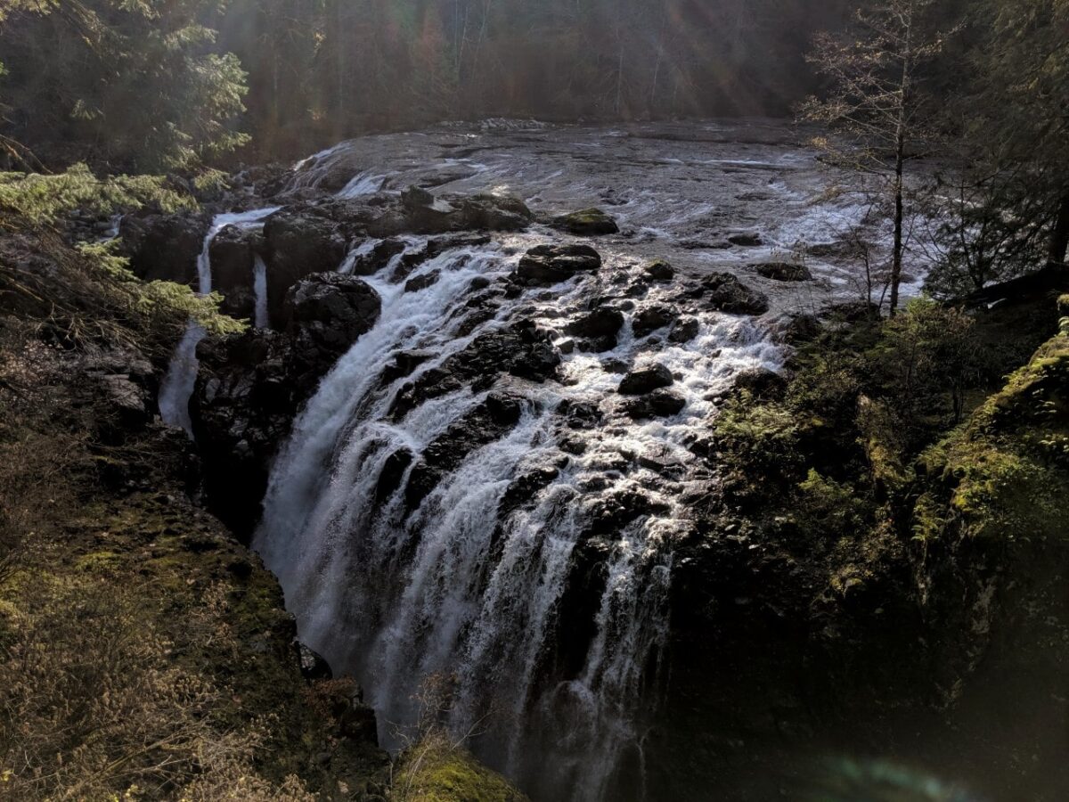
Elk Falls Provincial Park
Yet another impressive Vancouver Island waterfall lies just outside of Campbell River. Elk Falls plunges 25m into a deep canyon, a dramatic sight at any time of year.
For the most breathtaking views, walk the 60m-long suspension bridge across the canyon. This is definitely one of the best free activities on this Nanaimo to Campbell River road trip.

Elk Falls is accessible via an easy 800m-long forest hiking trail. There is a wheelchair-accessible viewpoint, with the suspension bridge located down a set of stairs. Another viewpoint is located 600m further up the trail.
Looking for a longer hike? There are longer circular routes in the park to enjoy (2-3 hours).
Distance from Nanaimo: 159km
Distance from Campbell River: 5km
Suggested time: 45 minutes to 1 hour

Best places to stay on a Nanaimo to Campbell River road trip
In Nanaimo, we like the Best Western Dorchester Hotel. Located downtown, it’s close to the Departure Bay ferry terminal and walkable to many local attractions. Some rooms have views of the harbour and all guests have access to free parking.
We’ve stayed at the Above Tide Motel half a dozen times while visiting Campbell River. While not fancy, the oceanside location of this property is incredible and the prices are pretty reasonable. Each room has a balcony with uninterrupted views of the Salish Sea.

For something a little more upmarket, try Painter’s Lodge. This iconic Campbell River property features a choice of cabins, suites and lodge rooms, many of which have ocean views.
Guests have access to tennis courts, a swimming pool, gym and hot tub. As of 2025, Painter’s is under new, BC-based, ownership.
As previously mentioned, Parksville, Qualicum Beach and Courtenay are also great places to stay while exploring Central Vancouver Island.
My top pick for accommodation in Courtenay is the Old House Hotel. This attractive property sits just in front of the Courtenay River, with the Courtenay Riverway walking trail just adjacent.
For a treat, consider a stay at Kingfisher Oceanside Resort and Spa. This beautiful waterfront resort is only 10 minutes drive away from Courtenay.
In Parksville, we loved our stay at Sunrise Ridge Waterfront Resort. The property features condo-style suites and vacation homes just steps away from the beach.

Other resources you may find helpful to plan your road trip:
25+ Amazing Vancouver Island Waterfalls You Must Visit
Where to Find Big Trees on Vancouver Island
22+ of the Best Campgrounds on Vancouver Island, BC
Cape Scott Trail, Vancouver Island: Complete Hiking Guide
Nanaimo to Tofino Road Trip Guide: 15 Amazing Places to Stop


One half of the Canadian/British couple behind Off Track Travel, Gemma is happiest when hiking on the trail or planning the next big travel adventure. JR and Gemma are currently based in the beautiful Okanagan Valley, British Columbia, Canada. Consider buying us a coffee if you have find any of our guides helpful!
We r new to the Island; live in Sooke! Interested in your blog ; especially your Nanaimo to Courtney travel! Please send info and itinerary of this tour and any others? We plan to explore the island this winter! Thx
Hi Lynda,
Thanks for your comment. You may find these other posts helpful for planning your travels around Vancouver Island:
Pacific Marine Circle Route: Best Places to Stop, Road Trip Itineraries
Nanaimo to Tofino Road Trip Guide: 15 Amazing Places to Stop
23+ of the Best Things to Do in Courtenay, Vancouver Island
Where to Find Big Trees on Vancouver Island, British Columbia
Thank you for writing such a great article! So many travel writer’s skip the beautiful Comox Valley area. So many exciting out door things to see and do. Great beaches,shopping, amazing locally owned restaurants and wineries. Such a special and unique area.
Thanks again for mentioning the area
Hi Sonora,
I’m so glad you enjoyd this post! We are big fans of the Comox Valley and agree that it has a lot to offer visitors. Thanks for sharing your thoughts, I appreciate the feedback. 🙂
Thrilled to have found your blog. As an 86 year old female with three geriatric dogs, living on Salt Spring Island, I have booked a BC Ferries vacation for early June travelling to Haida Gwaii. Essentially this is my one and only Bucket List item so I want me and my furry family to enjoy every moment. Our first overnight will be in Campbell River, our second in Port Hardy prior to boarding the ferry to Prince Rupert. Whilst on Haida Gwaii we will be staying at the HG Glamping resort for a few days. Many of the places to visit between Nanaimo and Campbell River that you have suggested are, regrettably, not suitable for four travellers with mobility issues (although I do actually have a neat stroller called a Dogger for my less able four-legged friend). If you can suggest a website that will give me information on dog-friendly parks/areas between Nanaimo and Campbell River I will be eternally grateful. It had already been suggested to me that I travel on Highway 19A rather than the main Highway 19 so it pleases me that you also recommend it.
Because of ferry/hotel bookings I am obviously on a schedule and am hopeful on my return trip to Salt Spring I can take a more leisurely approach, but initially I need to have a clear idea of locations and distances so I can plan in advance.
I look forward to hearing from you.
Hi Jean,
I am so happy to hear that you are going to Haida Gwaii and ticking off your bucket list item! I don’t have a specific website to direct you to (besides BC Parks and local municipal websites such as this one for Nanaimo) but I would recommend Rathtrevor Beach Provincial Park and Miracle Beach Provincial Park. Both welcome pets on leash. The parking lots are very close to the beach. Miracle Beach has a flat, established path just above the beach that you could walk with the dogs, while enjoying some beautiful ocean views.
Inland I would consider Nymph Falls Nature Park near Courtenay, as again, it has some wide, flat paths. The short 1km path to the waterfall (mentioned in the post) is wheelchair accessible. The park is, however, leash optional, which may not work for you.
I think you will enjoy the section of Highway 19A between Black Creek and Campbell River. Plenty of places to pull over and stop with the dogs, such as the Rotary Seawalk.