Travel from Vancouver Island’s east coast to west through its mountainous core, alongside huge lakes and waterfalls on a Campbell River to Gold River road trip.
While bearing similarities to the renowned Tofino route, this lesser-travelled version offers a delightfully uncrowded experience. This is one road trip in which the journey really is the destination.
The 100km drive to the terminus of Highway 28 beckons adventurous travellers to disconnect and revel in the beauty of nature, with no phone signal or Wi-Fi in sight.

I was reminded how much I love the Campbell River to Gold River drive on a recent Nootka Trail adventure.
It’s always impressive to me how remote the landscape feels soon after leaving Campbell River. The outdoor recreation opportunities also seem endless, despite many return visits.
In this post, I’ll share our favourite places to stop on a Campbell River to Gold River road trip with helpful tips to help you make the most of the journey.
There are affiliate links in this post. If you make a purchase via one of these links, we may receive a small percentage of the sale.

Planning a trip to Vancouver Island?

Our Vancouver Island Travel Guide features an interactive map with 150+ of the best things to see and do.
The itinerary builder tool makes it easy to create your perfect trip.
Download the app and use offline while travelling!
Campbell River to Gold River road trip: Essential details
Before getting into our top recommendations for must-see destinations between Campbell River and Gold River, let me offer some insights into the road trip route.
If you’re familiar with the area and just looking for ideas of where to go, feel free to skip ahead.
This road trip takes place in North Central Vancouver Island, British Columbia.
The driving distance between Campbell River and Gold River is 87.5km.

I would recommend, however, to continue on to the end of Highway 28, another 13.2km. The total one-way distance is therefore 100km and takes around 1 hour and 30 minutes to drive without stopping.
Given the abundance of beautiful places along the route, most roadtrippers will want to stop at least a few times.
This Campbell River to Gold River road trip route travels across the traditional territory of multiple First Nations, including the Nuu-chah-nulth, We Wai Kai, We Wai Kum, K’ómoks, Liǧʷiłdax̌ʷ and Kwakwaka’wakw A̱wi’nagwis.
Campbell River to Gold River road trip map

How to reach Campbell River
The northernmost city on Vancouver Island, Campbell River is located 260km from Victoria (a 3-hour drive) and 150km (90 minutes) from Nanaimo.
The primary route for visitors approaching Campbell River is by road from the south, utilising either Highway 19 or its coastal counterpart, Highway 19A.
Driving to Campbell River from Nanaimo? Don’t miss our road trip guide featuring all of the best things to do between Campbell River and Nanaimo.
The closest mainland ferry route to Campbell River is Departure Bay in Nanaimo. Ferries arrive here from Horseshoe Bay (West Vancouver). Additional services are available to Duke Point in Nanaimo from Tsawwassen (south of Vancouver).
While Campbell River does host a BC Ferries terminal, it serves only Quadra Island (with a connection to Cortes Island).

Driving between Campbell River to Gold River: what to expect
There is one paved road between Campbell River and Gold River- Highway 28. For most of the route, it is an undivided two-lane highway, with one lane in each direction.
While Highway 28 is frequently travelled, I would not say it is a busy road. Before you start your journey, check DriveBC for possible closures and construction.
There are not many passing areas on Highway 28 and the average speed limit is quite low (80km/h). Prepare for a slightly longer journey than you may initially expect. Industrial traffic can also slow drive time.
While Highway 28 is a fairly uncomplicated drive (no steep climbs or mountainous drop-offs), there are many curvy sections, with some tighter-than-you-may-expect corners.
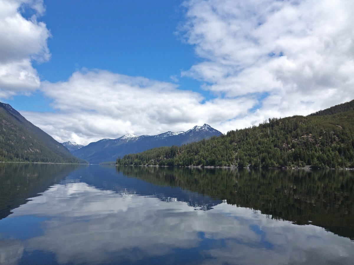
Large sections of Highway 28 are lined by forest (some plundered by logging operations), but some sections do have more views. The stretch along Upper Campbell Lake is really pretty, with peek-through water views on offer.

Good to know
- There is zero phone signal on this route after leaving Campbell River
- For the above reason, be sure to tell someone where you are going and when you plan to be back or check in with them again
- Services are very limited along Highway 28, with no gas stations between Campbell River and Gold River and only one restaurant. Bring extra food and water
- Wild animals can be present on the road at any time but particularly during dawn and dusk. This area of Vancouver Island is home to a large population of Roosevelt Elk as well as black bear and cougar
- Highway 28 travels through Strathcona Provincial Park. It’s a beautiful place but it is on the rustic side (no visitor centre)
- Always Leave No Trace while exploring!
Public transportation
Wondering whether you can take the bus between Campbell River and Gold River? Sadly not, there is no public bus operating between these two Vancovuer Island communities.
If you’re planning a hike in Strathcona Provincial Park and need a one-way shuttle, contact a private shuttle company such as Ambassador Transportation.

Campbell River to Gold River road trip: Best places to stop
It’s time to share our top picks for places to visit on a Campbell River to Gold River drive.
I would suggest at least 2 or 3 stops in each direction, assuming that you are driving from Campbell River to Gold River and back in one day.
If you are staying overnight along the route, you can visit most of the recommended places.

Elk Falls Provincial Park
Plunging 25m into a deep canyon, Elk Falls stands out as one of the most striking waterfalls on Vancouver Island.
Spectacular views are available from a 60-meter-long suspension bridge, along with several other vantage points.
The first viewpoint is wheelchair accessible. The suspension bridge is located down a set of stairs. The powerful force of Elk Falls is certain to leave an impression, no matter where you view it from.
Elk Falls is 800m from the parking lot, an easy 15-minute walk for most people. If you feel like a longer hike, it’s possible to continue on a circular route (instead of returning to the parking lot via the same trail).
Distance from Campbell River: 5km
Distance from Gold River: 83.4km
Suggested time: 45 minutes to 1 hour

Lake pullouts – Snakehead Lake, Echo Lake
Highway 28 winds its way through the forest to Upper Campbell Lake. It passes a number of smaller lakes, some with informal viewpoints (no facilities).
When travelling west, look for the pull-out on the edge of Snakehead Lake (Google Maps directions). It features a compact parking area with a view across the usually calm lake.
The pull-out next to Echo Lake (Google Maps directions) is much larger and requires no turning to exit. It is most easily accessed when driving east, back to Campbell River. Again, there is a good view of the tree-lined lake.
Distance from Campbell River: 15km / 22.6km
Distance from Gold River: 72.6km / 65km
Suggested time: 10 minutes
Elk Portal
The entrance to Strathcona Provincial Park, BC’s oldest, is marked with a large wooden carving of an elk.
This is one of the best places to stop for a picnic along Highway 28, with picnic tables and a couple of outhouses being provided.
While there is no access to the water, there are some beautiful peek-through views of Upper Campbell Lake and surrounding mountains.
Of course, the elk statue makes for a good photo opportunity as well. Look out for real elk as you drive from Campbell River to Gold River. The forest to the north of Highway 28 is home to several large herds.
Strathcona Provincial Park has no daily admission fees (unlike Canada’s National Parks) or parking fees.
Distance from Campbell River: 46.5km
Distance from Gold River: 41km
Suggested time: 10 minutes (more if you have a picnic)

Detour – Buttle Lake section of Strathcona Provincial Park
Buttle Lake is one of the star attractions on the Campbell River to Gold River road trip journey.
This deep, moody lake stretches 23km from Highway 28 into the mountainous heart of Strathcona Provincial Park.
A paved road borders the eastern side of the lake, providing regular glimpses of the (sometimes turbulent) water. The lake is backdropped by tall forested mountains.
Though Buttle Lake is technically a detour from Highway 28, I believe it is a must when taking a scenic drive from Campbell River to Gold River.

Viewpoints and trailheads are scattered along the road. Some of the latter lead high into the alpine, best suited for intermediate summer hikers looking for a full-day adventure (Flower Ridge Trail, Bedwell Lake Trail, Arnica Lake Trail).
There are short trails too, with my top picks being:
- Lupin Falls – easy 20 minute loop to a cascade in a mossy canyon
- Auger Point – peaceful lakeside spot close to the road
- Lower Myra Falls – 1.4km loop to rocky cascade, allow 45 minutes to one hour
My favourite part of the drive is at the southern end of Buttle Lake, where there are 360-degree views of the surrounding mountains. Of course, the panoramas are even more impressive when the lake is calm and has mirror reflections!
Distance from Campbell River (highway turn-off): 47.5km
Distance from Gold River (highway turn-off): 40km
Suggested time: 2.5 to 4 hours to drive 70km return trip to Lower Myra Falls with stops at three short trails mentioned

Big Den Rest Area
The Big Den Rest Area is a good place to stop for an extended break or picnic, with several outhouses and picnic tables.
Like the Elk Portal, this rest area is located next to Upper Campbell Lake. It does have lake access, however, which makes it a better choice on a warm day.
The beach is rocky but has some scenic views across to the mountains on the other side of the lake. Some areas of the lake shine turquoise in the sun.
Distance from Campbell River: 56km
Distance from Gold River: 31.7km
Suggested time: 10 minutes (more if you plan to have a picnic)

Lady Falls
Lady Falls is a beautiful sight to behold, emerging dramatically from a narrow slot canyon and cascading 27 meters onto a collection of rocks and debris beneath.
The 450m long trail leads through an old-growth forest to an elevated viewing platform. The path has a steady incline almost the entire way but it’s worth the effort.
Distance from Campbell River: 64km
Distance from Gold River: 23.5km
Suggested time: 30 minutes
Detour – Elk River Trail
If you’re looking for a rewarding full-day hike, check out the Elk River Trail. This valley bottom route travels below some of Vancouver Island’s highest summits.
The main destination for day hikers is Landslide Lake (21km return, 500m elevation gain), a spectacular teal-coloured waterbody backdropped by rugged Mount Colonel Foster.
21km makes for a long hiking day; a popular way to reduce the difficulty is to hike it as part of an overnight or three-day backpacking trip. There are two designated gravel bar campsites along the route.
An overnight trip makes the optional side trip to Foster Lake (also known as Berg Lake) more doable as well.
Though the starting point for the Elk River Trail is located on Highway 28, I’ve noted that it is a ‘detour’ since it is a full-day (or overnight) hiking experience.
Distance from Campbell River: 71km
Distance from Gold River: 16.5km
Suggested time: 6 to 9 hours
Gold River
The village of Gold River has a population of around 1,250 people and was established in 1965 to support the local logging industry.
A significant number of Gold River’s first residents were forcibly relocated by the federal government from the Mowachaht-Muchalat community of Yuquot on Nootka Island.
The pulp mill closed in 1998 and Gold River is now better known as a launching point for beautiful Nootka Sound.
Gold River is located just north of the convergence of the Gold and Heber rivers. The Peppercorn Trail is an easy 1km long forest walk along the Gold River, with access to several beaches.
The Heber River winds through a deep canyon before mellowing out and becoming crystal clear with many swimming holes. Dramatic views are on offer from the Matchlee Drive bridge and the nearby Heber River Trail.
In town, I’d recommend having a meal at the fabulous Sea & Field Bistro. This contemporary restaurant celebrates local flavours and ingredients, like rockfish and salmon.
Distance from Campbell River: 87.5km
Distance from Gold River: 0km
Suggested time: 1 to 2 hours
Detour – Upana Caves
Vancouver Island is a hotspot for caving, with more explored limestone caves than the rest of Canada combined. Upana Caves is one of the most accessible systems, just a short 25-minute drive (18km) along an unpaved road from Gold River.
There are fifteen entrances to Upana’s cave system, ranging from tiny passageways to large cathedral-like openings. The biggest concentration of caves is found 300m from the parking lot.
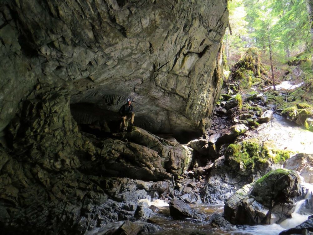
Be sure to take a couple of light sources and don’t go beyond your comfort zone. Some visitors bring a helmet to explore the smaller caves.
Another off-the-beaten-path destination in this area is Muchalat Lake. Also located down an unpaved road, this lake has a beautiful backdrop of mountain peaks. The Recreation Site campground next to the lake is $15/night during the main camping season (mid May to early September)
Distance from Campbell River: 105km
Distance from Gold River: 18.5km
Suggested time: 1 to 1.5 hours at the caves + 50 minutes for driving time

Tsuxwin Falls
Tsuxwin Falls is the second to last stop on this Campbell River to Gold River road trip. This tall waterfall cascades down the rocks beside the road and is particularly impressive during the spring run-off.
Hidden when approaching from the east, Tsuxwin Falls is best visited on the way back to Campbell River.
There are two parking areas close to Tsuxwin Falls, both on the right side of the road when driving east. The first offers great views of the river below, which is backdropped by forested mountains.
The second parking area has an interpretive kiosk. Follow the dirt trail east towards the picnic table and the waterfall will appear on the other side of the road.
Distance from Campbell River: 94.5km
Distance from Gold River: 7km
Suggested time: 10 minutes
End of Highway 28
Highway 28 ends on the edge of Muchalat Inlet, which leads to Nootka Sound. The road extends right to the water and is surrounded by a deep sea port.
Western Forest Products has a large logging operation here, as does Grieg Seafood. Air Nootka provides seaplane services and Get West Adventure Cruises operates sightseeing tours with the MV Uchuck III (more details below).
The port can be a busy place so be sure to park in an appropriate spot. The views of the surrounding mountains are fantastic from the end of the road. There’s also a little viewing platform over the Gold River estuary.
Distance from Campbell River: 101km
Distance from Gold River: 13km
Suggested time: 15 minutes

Detour – Nootka Sound and Yuquot
If you have the time, I’d highly recommend extending your Campbell River to Gold River road trip with a Nootka Sound cruise.
Nootka Sound is the passage of water between Vancouver Island and Nootka Island. It was originally named Mowichat by the Nuu-chah-nulth people.
The community of Yuquot (‘where the wind blows from all directions’) on Nootka Island’s southeastern tip was once a whaling and trading centre as well as the capital for all Nuu-chah-nulth nations.

Yuquot was also the location of the only Spanish settlement ever established in Canada and the landing place of Captain James Cook (Spain and England almost went to war over Nootka Island at one point).
Get West Adventure Cruises operates sightseeing cruises to both Nootka Sound and Yuquot aboard the MV Uchuck III maritime freighter.
Originally a WWII minesweeper, the Uchuck now supplies cargo to and from remote villages, fish farms, logging camps and resorts. Travellers are invited to tour the spectacular coastal scenery of Nootka Sound and also watch for marine life.
The cruises run on specific summer days and reservations are highly recommended. The Yuquot (Friendly Cove) trip is 6 hours long while the Nootka Sound tour lasts 9 to 12 hours.
Love the idea of Nootka Sound? If you’re a keen hiker, consider taking on the 4 to 5 day Nootka Trail. It is one of BC’s best coastal backpacking trips.
Distance from Campbell River: 101km
Distance from Gold River: 13km

Best places to stay on a Campbell River to Gold River road trip
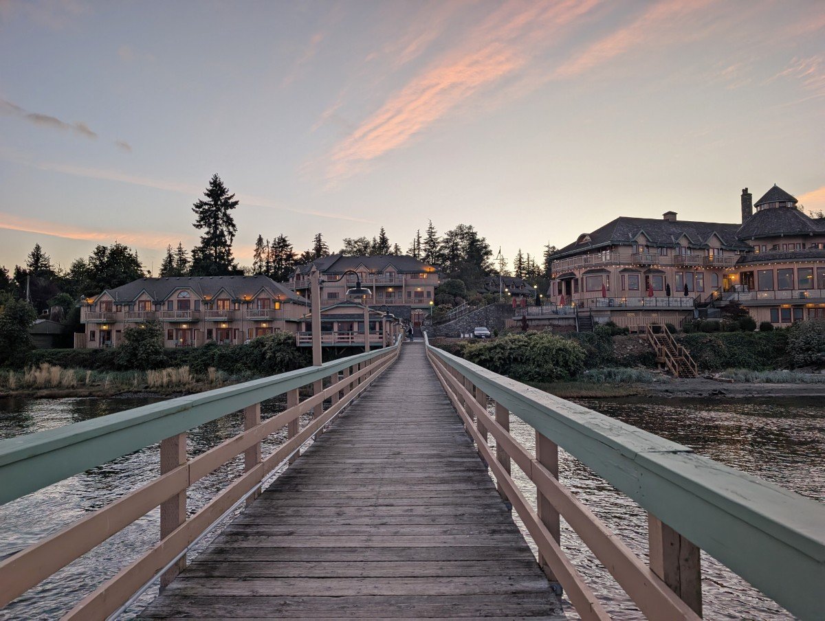
In Campbell River, we’d recommend Quinsam Campground for those with a low budget, the Above Tide Motel for non-campers and then Painter’s Lodge for a more comfortable, waterfront stay.
Located on the ocean to the north of town, Painter’s Lodge is an iconic historic hotel. In 2025, it was purchased by a BC-based hotel group, which plans to enhance the amenities while preserving the lodge’s original character.
The Above Tide Motel isn’t luxurious but the the beautiful oceanfront setting of this property and its reasonable prices make it a great choice for budget travellers. Each room features a balcony providing uninterrupted views of the Salish Sea.
Strathcona Park Lodge is the only hotel between Campbell River and Gold River. Situated just outside the park boundary, the lodge is completely off-grid and also operates as an outdoor education centre.
Although we enjoyed our expansive room with a balcony overlooking Upper Campbell Lake, we found it to be on the expensive side. Of course, it is a relatively remote area so that is a factor. Bring your own shampoo and conditioner.
Strathcona Lodge has an on-site restaurant serving buffet-style meals made with locally sourced, in-season ingredients. Reservations recommended.

In Gold River, the Ridgeview Motor Inn is our top pick. The property changed ownership a few years ago and all the rooms have been recently renovated.
The Gold River Chalet is another good option. The highly-rated accommodation offers a selection of comfortable rooms, with some featuring multiple double beds.
Camping options
Most campgrounds in this area are rustic, with limited services (outhouses only, no electricity, no showers).
Quinsam Campground in Elk Falls Provincial Park is a great option for camping near Campbell River, offering 120+ vehicle-accessible sites in a second-growth forest next to the Quinsam River. In late September, you can see black bears fishing for salmon in the river.
One of the best campgrounds close to Highway 28 has to be Upper Campbell Reservoir campground, almost halfway between Campbell River and Buttle Lake.
This BC Hydro campground has beautiful views of the lake and surrounding mountains. The sites are well-maintained and completely free to use (up to 14 days).
There are two vehicle-accessible campgrounds in Strathcona Provincial Park, both situated next to Buttle Lake. Ralph River (75 sites) is located about three-quarters the way down, while Buttle Lake campground (85 sites) sits at the very top.
Of the two, Buttle Lake is the most popular. Both campgrounds recently transitioned to 100% reservations only (first-serve sites still available if not already reserved).
Backcountry camping opportunities await on the western shore of Buttle Lake and also in the mountains above. The Bedwell Lakes Trail has a number of great options, all for $10/per adult/per night.

Other resources you may find helpful to plan your road trip around Vancouver Island
Nanaimo to Tofino Road Trip Guide: 15 Must See Places
22+ of the Best Campgrounds on Vancouver Island, BC
Pacific Marine Circle Route, Vancouver Island: Best Places to Stop, Road Trip Itineraries
Where to Find Big Trees on Vancouver Island
25+ Amazing Vancouver Island Waterfalls


One half of the Canadian/British couple behind Off Track Travel, Gemma is happiest when hiking on the trail or planning the next big travel adventure. JR and Gemma are currently based in the beautiful Okanagan Valley, British Columbia, Canada. Consider buying us a coffee if you have find any of our guides helpful!