San Josef Bay showcases true Vancouver Island coastal wilderness. Situated in the southwestern corner of remote Cape Scott Provincial Park, this stunning white sand beach is a wonder to explore.
For visitors willing to go the distance, San Josef Bay holds an extra surprise beyond its sandy shores and ocean vistas: majestic sea stacks, sculpted by the relentless ocean waves.
In this post, I’ll tell you all about San Josef Bay, the hiking trail to reach it, essential camping details, how to get to the parking area and where to stay nearby.

We’ve explored Cape Scott Provincial Park three times now, in three different seasons (spring, summer, fall).
It’s a place that feels so familiar to me and one I just keep longing to return to. I’m sure you’ll feel the same after visiting San Josef Bay!
This post contains affiliate links. If you make a purchase via one of these links, we may receive a small percentage of the sale.
An introduction to San Josef Bay
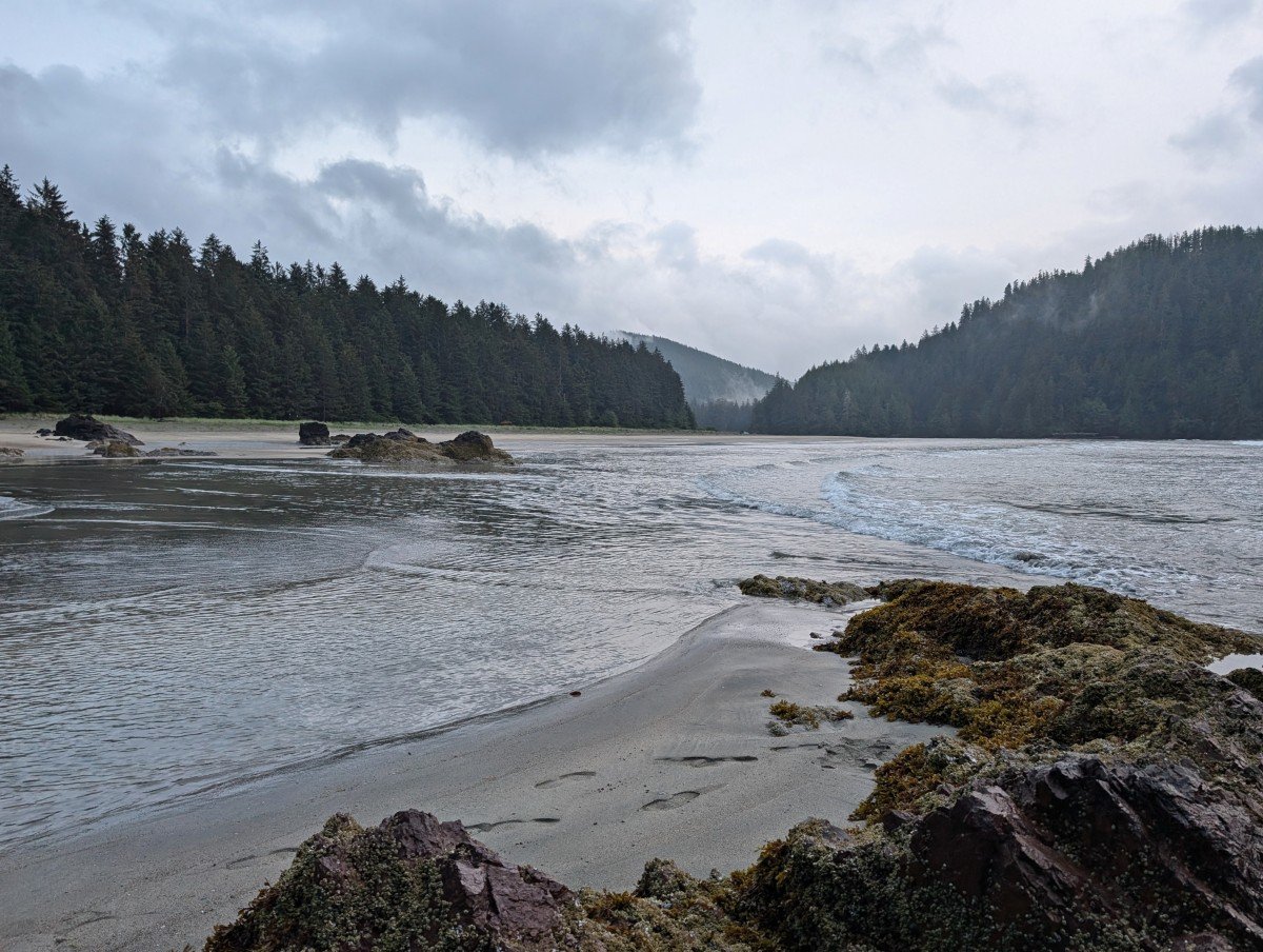
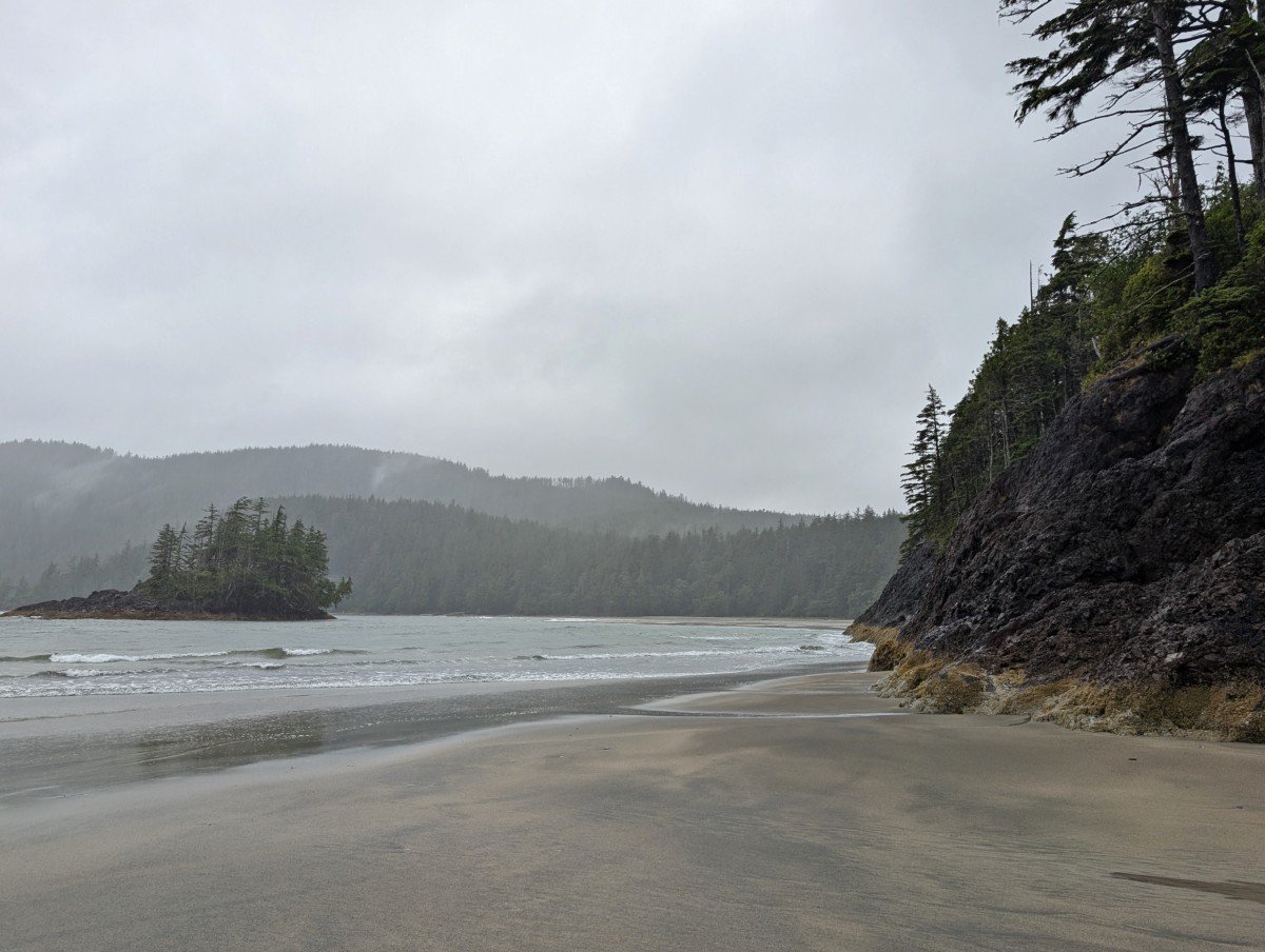
San Josef Bay is a spectacular crescent of soft white sand located in Cape Scott Provincial Park, British Columbia. It is only accessible on foot or by boat.
Separated into two sections by a headland, both beaches offer sweeping views of the ocean and surrounding hills, sometimes obscured by atmospheric mist and fog.
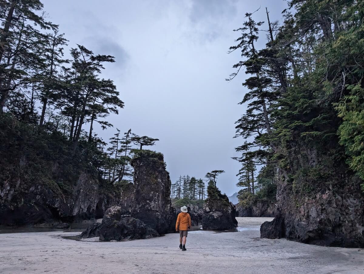
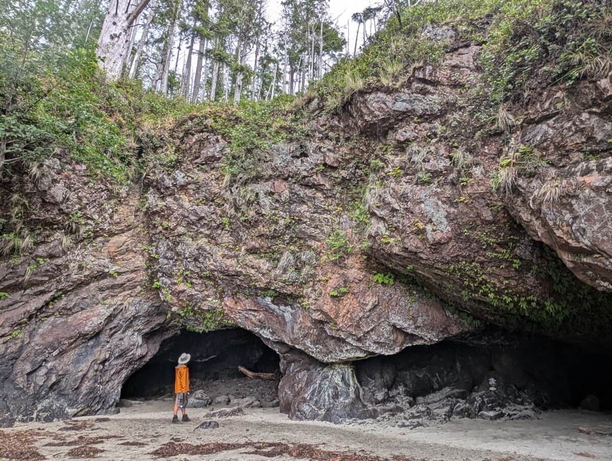
At lower tides, it is possible to walk between the two beaches. The highlight of the transition is a collection of rocky sea stacks topped with bonsai-like trees. This is what San Josef Bay is best known for.

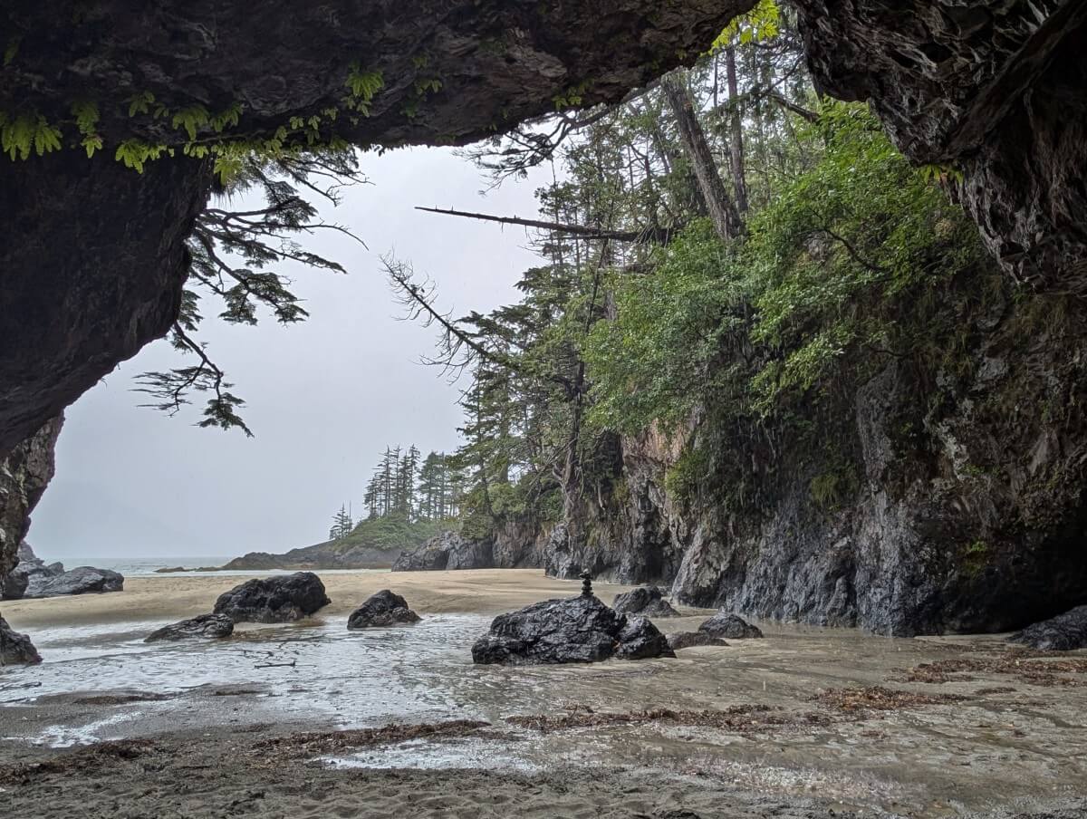
Shaped by the pounding surf, these formations have a strikingly delicate but imposing appearance, almost like natural sculptures standing on guard. The nearby headland is also lined with intricate caves at its base.
Needless to say, there’s a lot to take in and explore. Only 45 minutes walk (2.5km) from the parking lot along a well maintained, mostly flat trail, it’s no surprise that San Josef Bay has become so popular.
Despite the relatively remote location and high annual rainfall, San Josef draws plenty of day visitors. It’s also a very popular camping destination.
Perfect for first time backpackers, families and anyone looking for an easy one night camping trip, San Josef is also utilised by Cape Scott Trail and North Coast Trail hikers on longer trips.
Indeed, we stayed at San Josef on our last night of an epic 8 day backpacking adventure combining both of the aforementioned trails.
Essential details
- Free to visit and open all year round (check for advisories/temporary closures)
- May to September is the most popular time to go,
- Busiest in July and August – warmest, driest weather though there is a risk of fog
- 295km from Campbell River, 450km from Nanaimo
- The drive from Port Hardy to the trailhead is 67km but takes around 2 hours
- The access road is unpaved and can be slippery when wet
- 2.5km hike from the parking area, about 45 minutes
- Allow 1 to 2 hours to explore when visiting for the day
- Beach camping, $10/per person/per night (May to Sept), no reservation system
- Bring water as the water source can be hard to reach
- Leave No Trace – pack out everything you bring with you
A brief history of San Josef Bay
Cape Scott Provincial Park is the traditional territory of the Tlatlasikwala, Nakumgilisala, and Yutlinuk. The latter unfortunately no longer exist, but the latlasikwala and Nakumgilisala merged together in the 1850s and later joined the Koskimo people to become known as the Nahwitti. There are three Nahwitti reserves in Cape Scott Park today.
European settlement of this area began in the late 19th century, first by ethnically Danish settlers from the US. They built their settlement around the newly named Hansen Lagoon and Fishermen Bay, further north of San Josef.
A combination of the harsh climate and lack of transportation linked forced the group to leave less than a decade later.
In 1913, a second group attempted to settle here, this time from the US, Canada and Europe. They based themselves in Hansen Lagoon, Fisherman Bay and also San Josef Bay.
At its height, the settlement grew to 1,000 residents before running into familiar difficulties and further worsened by conscription during WWI. In both instances, the BC government failed to come through with a promised road connection.
Cape Scott Provincial Park was established in 1973.
San Josef Bay hiking trail
The San Josef Bay Trail is 2.5km one-way and takes around 45 minutes to walk. I say ‘walk’ specifically, as it is an accessible route that most people can enjoy.
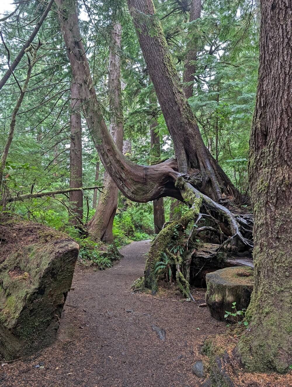
The path is wider than a hiking trail, mostly flat and even. It is well maintained, with medium to hard gravel and some short boardwalk sections.
In theory, the trail is both stroller and wheelchair accessible but I believe that would depend on the type of wheelchair. Some assistance may be needed on the small inclines.

After heavy rain, water can pool on some of the flatter areas. There are some smaller tree roots and rocks to look out for, but for the most part, the trail has been very well cleared.
The parking lot has outhouses, a large picnic shelter and kiosk information.
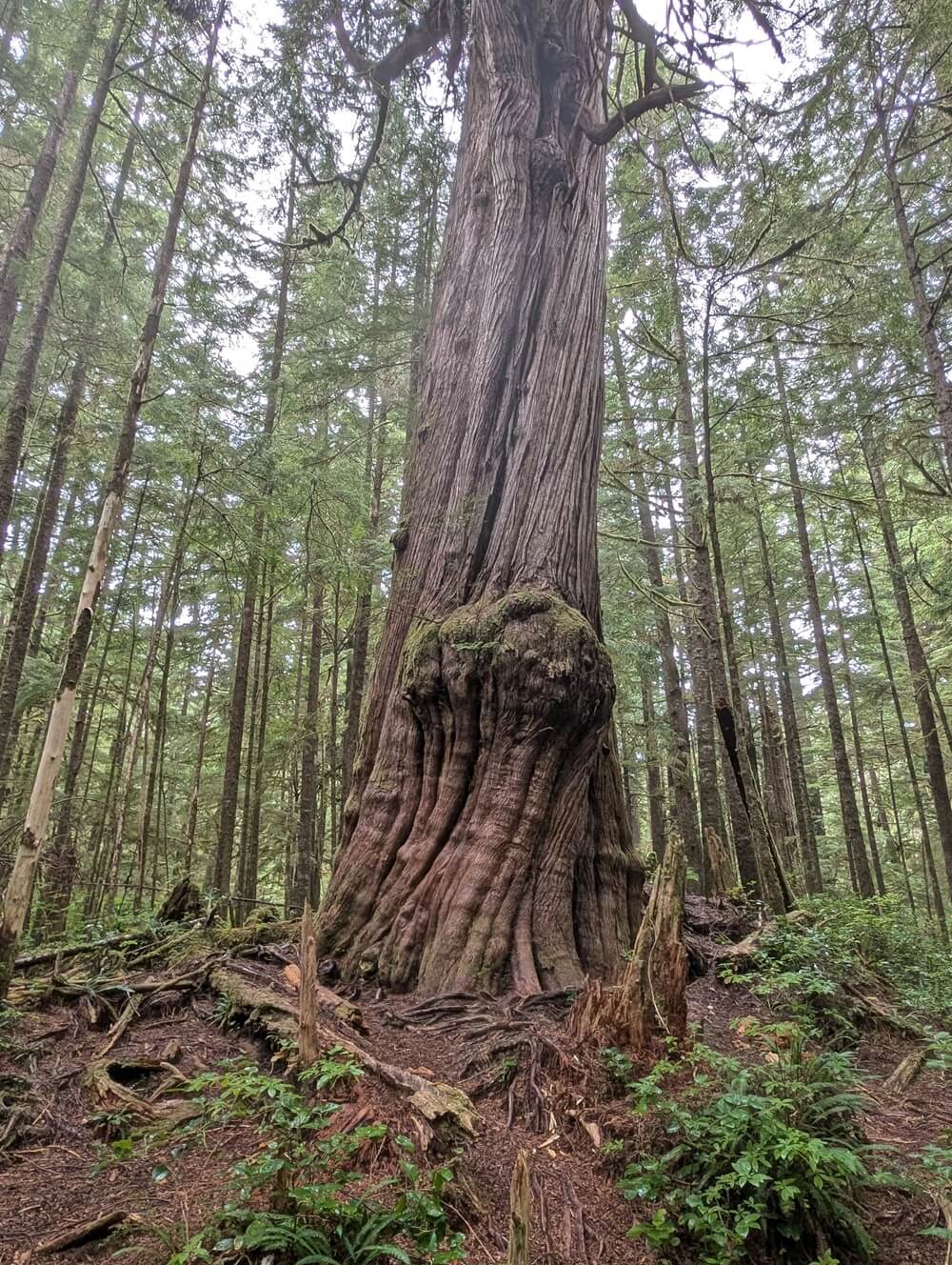
As for the trail experience, it is forested for the entire route with many gorgeous layers of green – ferns, shrubs, old growth trees, thick moss. Huge tree trunks and root systems line some sections of the trail. Look for mushrooms as well.
A large old growth western cedar tree is Sitka Spruce is located around the midway point. The high annual rainfall of this area has certainly helped it grow!
An information panel explains the story of the 20th century Danish settlers, with a couple of photos.
Reaching San Josef Bay
The main part of the trail ends at a kiosk, which features a tide table and warnings about rip currents. There is an accessible outhouse (with ramp) here as well.
The ocean can be heard at this point and is visible through the trees. The path gives out to sand quickly, with the beach stretching into the distance. To visit the sea stacks and the second beach, head west (to the right).
The sea stacks are about 700m from the end of the trail. Be sure to check out the cave as well! It rained a lot on our last visit so the cave was useful for shelter.
Beyond the sea stacks, the headland blocks across to the second beach at high tide. Based on my estimates, you need tides of less than 2m walk around. Otherwise, the only access is via a very steep, rugged trail over the headland.

Planning a trip to Vancouver Island?

Our Vancouver Island Travel Guide features an interactive map with 150+ of the best things to see and do.
The itinerary builder tool makes it easy to create your perfect trip.
Download the app and use offline while travelling!
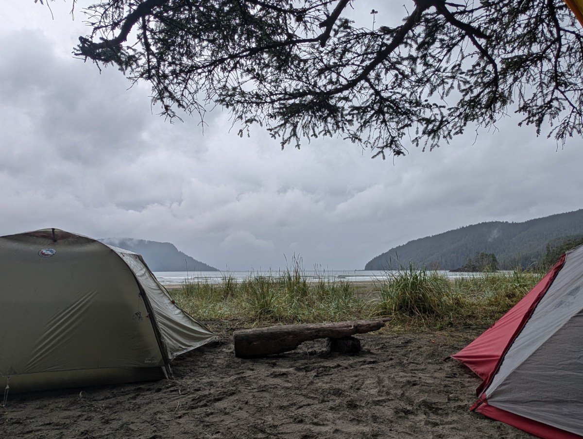
Camping at San Josef Bay
San Josef Bay is home to one of the most beautiful beach campgrounds in BC. Luckily then, it is BIG! There is lots of space on the sand and along the edge of the forest.
Camping is permitted on both beaches. Keep in mind that the second beach is only accessible at low tide or via a short, steep, rugged inland trail. Located to the east of the sea stacks, it is marked by buoys. The lack of 24/7 access does mean that the second beach is quieter.
For the tide times, refer to the Cape Scott tide table (the closest reporting station). Be sure not to get caught out and stuck on the second beach.
On our last trip, we were at San Josef from 6pm to 10am and we couldn’t visit the second beach at all due to the high tides being in the evening and early morning (unless we wanted to go in the middle of the night).
By my estimates, you need tides of less than 2m to be able to go all the way around the headland.
Important things to know
- Camping fees are $10/per person/per night from 1st May to 30th September (free otherwise)
- There is a self-registration vault for fees in the parking lot, so bring cash or pay online for a Backcountry Camping Permit up to two weeks in advance (click the ‘backcountry’ tab then select ‘backcountry registration.’)
- Campfires are allowed on the beach, when there is no fire ban. Be sure to check the BC Wildfire Service website heading out – San Josef is in the Coastal Fire Zone
- San Josef Bay does not have a reservation system for camping. Backcountry camping permit numbers are unlimited. Purchasing a permit does not allocate you a spot on the beach
- The first beach has five urine diversion outhouses, one with a ramp (great for accessibility!) The second beach has outhouses as well. To locate them, look for buoys in the trees
- There are eight large metal food caches in the forest behind the first beach (close to the outhouses), additional food caches on the second beach
- Summer weekends are very busy, with the busiest time of all being the first weekend of August (BC Day holiday weekend). At that time, all of the food caches at San Josef Bay are completely full
- Since the trail from the parking lot to the first beach is so flat, some campers use a wheeled wagon to transport their camping gear
- There is no phone signal in this area so be sure to tell someone where you’re going and when you plan to be back. Expect to have no phone signal after leaving Highway 19 so definitely send a message early!

Water source
The ONLY downside of camping at San Josef Bay? The lack of a real water source. There is a creek on the second (western) beach about 1km from the first beach, but at high tide it is only accessible via a short but challenging inland trail. It’s very steep and very rugged.
During dry periods, the second beach creek has a lower flow and can apparently get pretty brown. Be sure to bring a good water filter – we use the BeFree. It’s light to carry, fast to use and pretty cheap.
If you’re planning to stay at San Josef Bay for only one night, I would plan to bring in all the water you need for your stay. There really isn’t a more convenient water source than the creek on second beach – we tried to find one but the river close to the first beach is brackish (salty).
Essential items to bring
- Tarp – A tarp (like this lightweight one) can provide shade on sunny days and shelter on rainier ones. Beach camping can feel very exposed. Bring some extra cord for attachment
- A leash for your dog – San Josef Bay is the only area in the Cape Scott where dogs are allowed. This is mainly due to the amount of resident wolves and bears. Please keep your dog on a leash
- Tent stakes – If your tent is not freestanding, consider bringing some sand stakes or extra cord to help secure your tent while camping on the beach.
- Satellite communication device – There is zero phone signal in this region of Vancouver Island. For emergency purposes, we always bring an InReach device on backpacking trips
- Bear spray – We always have bear spray in the backcountry. Bear spray is helpful to have as a last resort in the unlikely event you need it. Carry the canister in an accessible place and know how to use it
- Camping permit – Don’t forget to bring a copy of your camping permit if you purchased it online
- Layers of clothing, rain jacket – Coastal weather can change really quickly. Rain is possible at any time of year. It can downpour for days at a time (we witnessed that in August!)
For more packing tips for multi-day hikes, head to our comprehensive packing guide.
How to get to San Josef Bay
San Josef Bay is located in Cape Scott Provincial Park, which is situated at the extreme northwestern tip of Vancouver Island, British Columbia. As mentioned, it is only accessible on foot or by water.
The parking lot is also the main parking area for the entire Cape Scott Provincial Park. Getting there requires more effort compared to some other popular places on Vancouver Island.
The main access route is a combination of unpaved industrial roads. The distance from Port Hardy is only 67km but it takes around 2 hours to drive.

Depending on recent maintenance and weather, the road can be rough to drive. Other times, it may be smoother. Regardless, it’s still a gravel road and driving it should not be taken lightly – this is not a highway!
Driving a rental vehicle? Check first – most rental companies prohibit driving on unpaved roads like this. Personally, I would not bring a large RV either.
Driving tips
- Be prepared drive slowly (40-50km/h). The access road is bumpy in places and can be very slippery when wet
- A high-clearance vehicle is recommended. Drive with headlights on at all times and be prepared to pull over for industrial traffic (smaller white trucks, huge logging trucks). Use caution around corners and avoid the soft shoulders
- Bring a full-size spare tire and be familiar with changing it. One time, we passed two groups of people changing tires!
- Some of the roads leading to the park are occasionally closed for maintenance – check the BC Parks website for notices before heading out
- Fill up your gas tank before leaving Port Hardy. Bring everything you need with you for the trip. Holberg (population 200) has a very well equipped General Store but don’t rely on it
- On arrival at the parking lot, be prepared to park on the road if necessary. Don’t leave valuables in the vehicle
Where to stay near San Josef Bay
If you don’t to camp at San Josef itself, the Western Forest Products San Josef River Recreation Site campground is just a few minutes from the park entrance. It’s a bit weathered but completely free to use.
There are about eight campsites beneath old growth tree canopy, with outhouses, picnic tables and fire pits. Warning – this campground can flood quickly in heavy rain.

Another option is the privately run San Josef Heritage Campground. Please note that camping/sleeping in a vehicle in the Cape Scott parking lot is officially prohibited.
Further away is the Nahwitti Lake Recreation Site. It’s located along the Holberg Road from Port Hardy. The campsites are surrounded by huge balsam and hemlock trees.
The closest accommodation to San Josef Bay is the Adventure Huts in Holberg. These small handcrafted cabins are on the basic side but have everything you need for a night in a remote area.
Port Hardy has a good range of accommodation to choose from, including some inns, a backpackers hostel, guesthouses, B&Bs and hotels.
The Quarterdeck Inn is a comfortable option by the marina. Closer to downtown, the Kwa’lilas Hotel is a stylish, modern pick and is owned by the Gwa’sala ‘Nakwaxda’xw First Nation.
Other posts you may find helpful
Campbell River to Port Hardy Road Trip Guide
Little Huson Caves Guide, Vancouver Island
27+ of the Best Things to Do in Campbell River, Vancouver Island
25+ of the Best Campgrounds on Vancouver Island
How to find Big Trees on Vancouver Island
Hiking to Della Falls, Vancouver Island’s Highest Waterfall
A Complete Guide to Storm Watching in Tofino


One half of the Canadian/British couple behind Off Track Travel, Gemma is happiest when hiking on the trail or planning the next big travel adventure. JR and Gemma are currently based in the beautiful Okanagan Valley, British Columbia, Canada. Consider buying us a coffee if you have find any of our guides helpful!