Two rail lines once crossed the length of British Columbia’s Boundary Country – the Kettle Valley Railway (KVR) and the Columbia and Western (C&W).
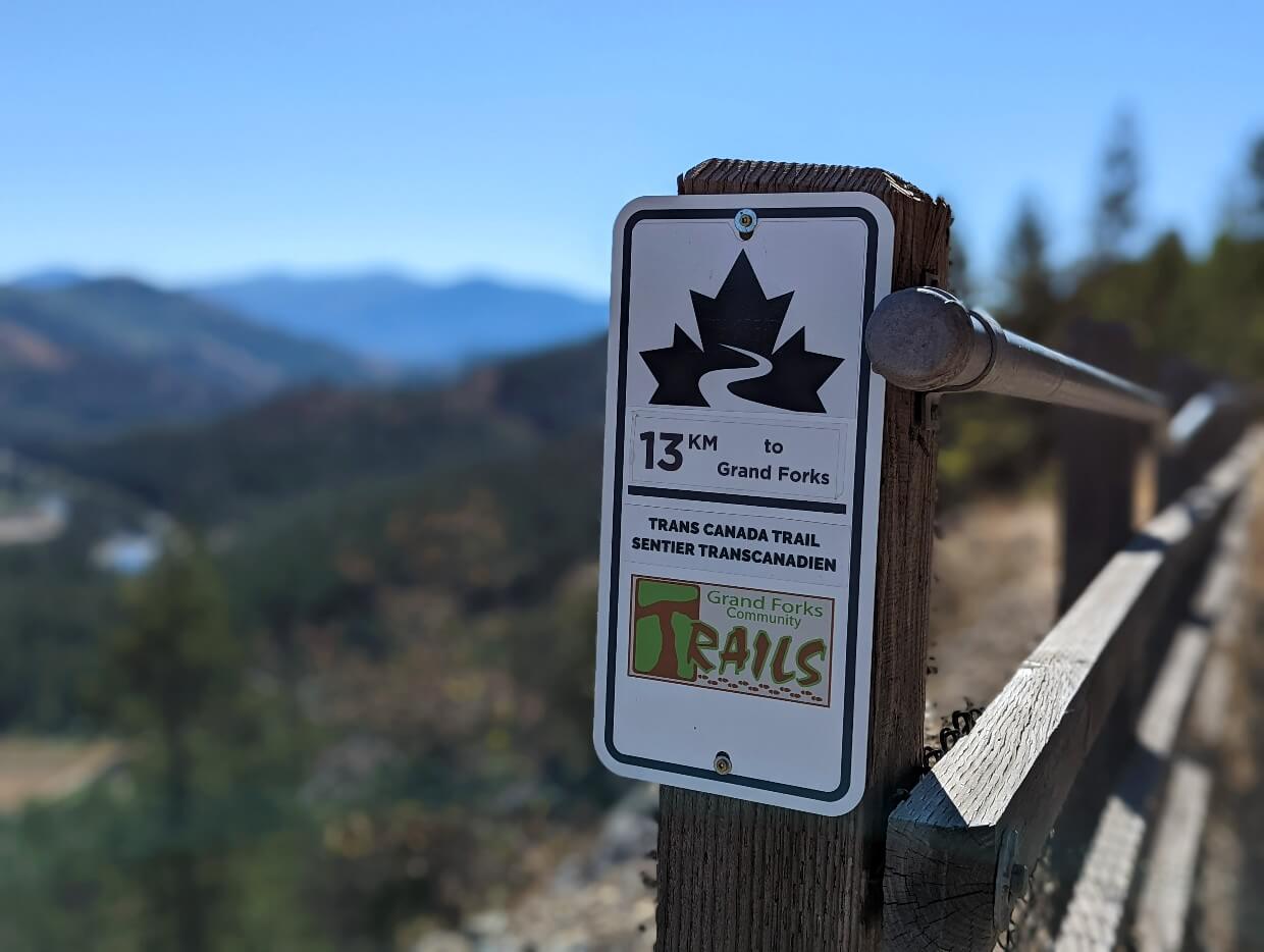
Now converted into multi-use paths, the KVR and C&W connect in the town of Midway to provide an almost uninterrupted 170km hiking and biking route across the region, which is also part of the Trans Canada Trail.

Some highlights include:
- Wide path with a very gentle grade – great for accessibility
- Waterfalls, canyons, rapids, rivers, sandy beaches and more
- Scenic views, including sweeping valley views and golden grasslands
- Community connection – start in one town and visit another for lunch
- Interesting railway features such as tunnels, trestles, old stations
- Many trailheads – choose your own adventure!
- Urban AND wilderness sections
- Historical insights into the region
- No fees to pay or permit to acquire
Though we had enjoyed a teaser of the C&W on our last visit to Boundary, we set out to do it better justice on our return.

In this post, I’ll be showcasing some of the best sections of the KVR and C&W to hike and bike, plus all the details you need to know to explore safely.
Of course, I’ll also share our favourite places to stop on the way, so you can stay fueled and rested while adventuring in Boundary Country!
Here’s what to expect:
- An introduction to Boundary Country’s Rail Trails
- Exploring the KVR and C&W Rail Trails
- Trip planning
- Where to stay, stop and eat in Boundary Country
Boundary Country is located within the traditional territory of the Ktunaxa, Sinixt and Okanagan Nations.
This post is in partnership with Boundary Country Tourism.
This post includes some affiliate links. If you make a purchase via one of these links, we may receive a small percentage of the sale.

Introducing Boundary Country’s Rail Trails
Boundary Country is a delightful region of southern British Columbia, bordered by the Okanagan Valley, West Kootenays and US border.
Crossed from east to west by two rail trails, Boundary Country is an ideal destination for both biking and hiking.
The 170km route travels through pine forests, rolling farmland, wide river valleys and characterful communities, all with a backdrop of sun drenched mountains.
A range of trailheads provide opportunities for long and short adventures, both in urban and wilderness environments. And most importantly, the gentle grade of the wide path is welcoming to trail users of many ages and abilities.
As noted, Boundary Country’s Rail Trails are also completely free to explore. Donations to BC Trails and local maintenance organisations, such as the Grand Forks Trail Society, are gratefully accepted, however.

A brief history of the KVR and C&W
While the KVR and C&W physically connect in the town of Midway, these former rail lines are intricately linked by history as well.
Built primarily to serve local mining interests and ensure Boundary Country’s economic prosperity, the KVR and C&W also created a vital link between the Kootenays and the Coast (Vancouver, Victoria).

Furthermore, both railways helped to maintain Canadian sovereignty during a time when officials were concerned about American miners flooding the area and railroad competitors gaining a monopoly.
For more information about the history of either of these rail trails, check out the Columbia and Western Society website. While travelling the region, be sure to drop by the Kettle River Museum, Greenwood Museum, Boundary Museum (Grand Forks) and Christina Lake Welcome Centre.

The Kettle Valley Railway (KVR) Trail
Starting construction in 1910, the Kettle Valley Railway (KVR) line travelled almost 500km from Midway to Hope. It was used for transporting ore, fruit and other goods as well as passengers.
Highway construction was a primary factor to the KVR’s decline in the 1960s. The last train travelled on the Penticton section in 1989. Development of the multi-use Kettle Valley Rail Trail network started in the 1990s.

The most well known section of the KVR is situated in Myra Canyon, where the path crosses 18 wooden trestle bridges.
Mile 0 of the KVR is located in Midway, just behind the Kettle River Museum. The route then travels west, passing through Kettle Valley and Rock Creek before turning north to Westbridge, Beaverdell and Carmi. The KVR then continues beyond Boundary Country to the outskirts of Kelowna.
Read More: Hiking the Kettle Valley Rail Trail in Penticton, BC

The Columbia and Western Railway Trail (C&W)
The Columbia and Western Railway stretched stretched 162km from Midway to Robson West (now known as Castlegar).
Originally conceived in 1890 to transport ore all the way from a smelter in Trail to Penticton, westward expansion stopped in Midway when the KVR was commissioned. The C&W also transported passengers as well as goods.

Operating a little longer than the KVR, the C&W’s tracks were not removed until 1990. A very small section remains still in active use by the local industry in Grand Forks.
Mile 0 of the C&W is also located behind the Kettle River Museum in Midway, seamlessly connecting with the KVR Trail. The route travels east, passing through Greenwood, Eholt, Grand Forks and Christina Lake. It then turns north and leaves Boundary Country as it heads towards Castlegar.

Exploring the KVR and Columbia & Western Rail Trails
The Kettle Valley Railway and Columbia and Western are now popular multi-use paths and part of the Trans Canada Trail.
Many sections are open to both motorised (ATV, powered bikes) and non-motorised traffic (walkers, cyclists and equestrians). Some areas are strictly non-motorised only.

With more than 170km of trail to explore, it can be difficult to decide where to start.
Read on to discover more than a dozen recommended sections of trail, ranging from 400m to 49km in distance, the majority tried and tested by us. I’ve noted starting points, highlights, parking information and facilities.
The longer routes are intended for cyclists, with the shorter routes ideal for cyclists and walkers.
Short adventures
The following suggestions are perfect for rail trail users looking for a few hours of exploration (or less). We have personally walked each route and also cycled some too. Use the below map to locate the trailheads.
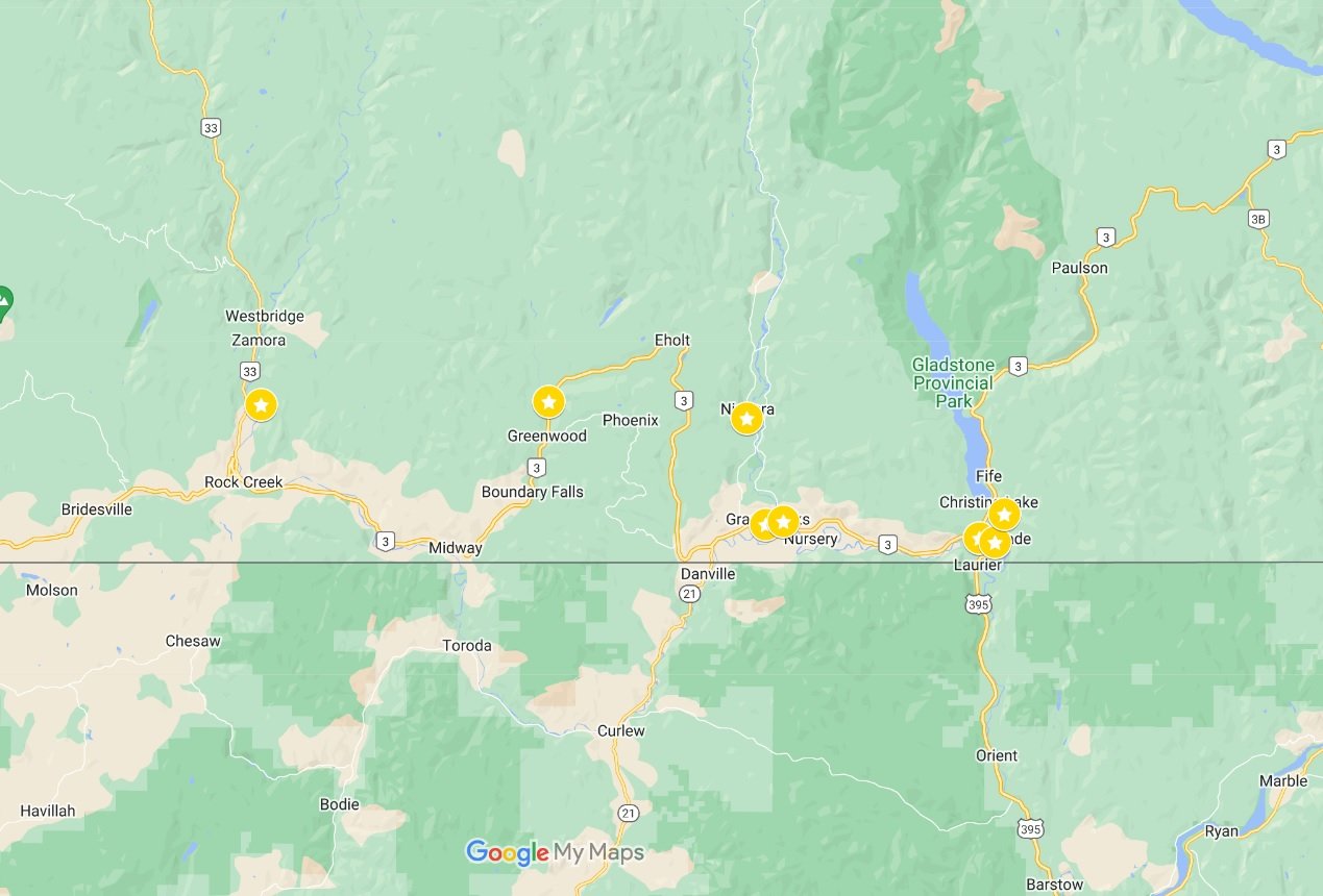
Kettle River Recreation Area, Rock Creek
The Kettle River Recreation Area is an ideal starting point for a short hike or cycle on the KVR Trail.
There’s a large day use parking lot just a short walk from a beautiful trestle bridge, also a popular swimming spot. Head north or south as far as you like from here; the trail weaves along the river, sometimes offering water views.
Prefer to hike/bike with a specific destination in mind? Consider the 13km return trip from the recreation area to Rock Creek. Grab an ice cream at the Rock Creek Station or stop for lunch at the Prospector Pub before heading back to your vehicle.
Start: Kettle River Recreation Area day use parking lot near Rock Creek
Parking: Large tarmac provincial park lot
Facilities: Outhouses, trash bins
Attractions: Trestle bridge, swimming beach, river

Tunnel of Flags, Greenwood
A slightly peculiar looking tunnel sits adjacent to northern highway exit of the tiny city of Greenwood. It was built in 1913, underneath a railway trestle that has since been removed.
The tunnel may not lead anywhere now, but it’s still interesting to view. Flags from around the world were painted on the outside in 2000, a project led by the local mayor.
The Columbia & Western leads away from the tunnel on the other side of the road. This section offers a pretty walk through the forest, with intermittent sounds of the nearby creek and some hints of colour in late September. Walk as far as you like before returning to the parking area.
Start: Tunnel of Flags in Greenwood
Parking: Small gravel area just off highway
Facilities: None, but very close to Greenwood
Attractions: Historic railway tunnel painted with flags

Fisherman Creek Falls, Grand Forks
Fisherman Creek Falls is a small cascade located less than 500m from the Columbia and Western Rail Trail.
Hidden by nature (quite literally!), this little waterfall is a lovely detour from the rail trail or a destination in its own right. Look out for some impressive old growth cedar trees close to the cascade.
To find Fisherman Creek Falls, head to Fisherman Creek Forest Service Road (just off the Old North Forks Road). If you have a low clearance vehicle, park at the bottom and walk the 1.6km uphill to the C&W.
At the top, look for the brown trail signage behind the C&W kiosk. A steep path leads down to the creek. At the junction, turn right for the falls or left to visit a (slightly creepy!) culvert tunnel, built in 1910. Return the same way or follow the path on the other side of the creek to complete a loop.
For a longer adventure, consider visiting the Fisherman Tunnel as well. It’s another 2km from the C&W and Fisherman Creek Falls junction (more info below).
Start: Fisherman Creek Forest Service Road, near Grand Forks
Distance: 4km return
Parking: Side of gravel road
Facilities: Signage
Attractions: Waterfall, historic tunnel, old growth trees

Fisherman Tunnel, Grand Forks
I absolutely love railway tunnels and so was pretty pleased to find this one so close to Grand Forks. Blasted right through the rock over a hundred years ago, the 125m long Fisherman Tunnel remains impressive today.
At the southern side of the tunnel is an outhouse, picnic bench and railway shed. The latter once housed the C&W’s avalanche inspector. It is now a shelter. The views of the valley are fantastic from here, another good reason to make the journey.
To find Fisherman Creek Falls, head to Fisherman Creek Forest Service Road (just off the Old North Forks Road). If you have a low clearance vehicle, park at the bottom and walk the 1.6km uphill to the C&W. The tunnel is located 1.9km to the north.
For a longer adventure, consider visiting Fisherman Creek Falls as well. It’s a very short detour from the Fisherman Creek Forest Service Road and C&W junction (see above for details).
Start: Fisherman Creek Forest Service Road, near Grand Forks
Distance: 7km return
Parking: Side of gravel road
Facilities: Signage, map, shelter, bench, outhouse
Attractions: Historic railway tunnel, scenic views

Black Train Bridge Trail, Grand Forks
This out and back route suggestion is courtesy of the Grand Forks Community Trail Society (find a map and longer description on their website).
As a paved, flat urban trail with lighting, this easy trail is super accessible and also family friendly. There are a number of highlights, starting with the Black Train Bridge.
Enjoy the scenic views of the Kettle River before following the edge of the water to the Community Gardens. Turn around here and then cross the bridge again, to view the restored CPR tool shed.
The route then winds its way along an abandoned oxbow of the Kettle River, through a subdivision, across the highway (use the stoplight a block away) and finally to the Grand Forks Station Pub.
Stop for a drink or lunch and enjoy the original features of BC’s oldest CPR station still in its original location. Return to the parking area the same way.
Start: Kettle River Drive, Grand Forks
Distance: 3.8km return
Parking: Small gravel area next to road or street parking
Facilities: Paved path, lighting, signage, steps to beach
Attractions: Trestle bridge, CPR tool shed, historic pub, beach

Roxul Parking Lot to Nursery Trestle, Grand Forks
This short but sweet section of the C&W follows the Kettle River from Grand Forks’ industrial area to the picturesque Nursery Trestle. Being completely paved, it is family friendly and also very accessible.
The river below the Nursery Trestle is a popular swimming spot, with easy beach access on the western side of the bridge. The water turns a little turquoise on sunny summer days. An outhouse and picnic table can be found on the other end of the bridge.
The Roxul Parking Lot is located on 68th Street. Though decently sized gravel lot, it can get busy in summer. An alternative solution is to park in downtown Grand Forks, which is only a few blocks away (additional 800m one-way).
Start: Roxul Parking Lot, 68th Ave, Grand Forks
Distance: 3.2km
Parking: Small gravel parking lot
Facilities: Paved path, signage, outhouse, bench, beach access
Attractions: Trestle bridge, beach

Roxul Parking Lot to Boothman’s Oxbow Provincial Park, Grand Forks
This is an extension of the Roxul to the Nursery Trestle trip (as suggested above), ideal for cyclists looking for a longer ride.
A gorgeously golden grass landscape starts to appear after crossing the bridge, with high rock cliffs bordering the highway on the left hand side. The paved section continues for another few kilometers, before transitioning into packed/loose gravel.
The end point of this suggested trip is Boothman’s Oxbow a small provincial park nestled on the shore of the Kettle River. A short (but slightly overgrown) path leads down to a beautiful sand beach.
Please note that this route has zero shade. Be careful to take appropriate precautions (sun protection, water, start early), especially during in summer. There are some gates along the way that must be opened and shut.
Start: Roxul Parking Lot, 68th Ave, Grand Forks
Distance: 14km return
Parking: Small gravel parking lot
Facilities: Signage, outhouse on route, bench, beach access
Attractions: Trestle bridge, several beaches, riparian ecosystem

Cascade Gorge, Christina Lake
This is definitely one of the ‘must do’ sections of the C&W in Boundary Country!
Cascade Gorge is host to a number of exhilarating rapids, steep cliffs and a thundering 31m high waterfall. It was also the location of the region’s first AC power generating station.
A railway trestle bridge, just 200m from the closest parking area, provides a great vantage point of the narrow rock fissure.
If you’re looking for a longer adventure, continue on the C&W east to Cascade Falls. The detour is 300m past the bridge. Cross the old concrete bulkhead and then follow the trail to the right to the cliff face. Keep children and pets very close here as there is no fence.
Still looking for more? Return to the C&W and continue east for another 2km. The trail will lead you to the dramatic Smitten Trestle Bridge, more information below.
Start: Cascade Trestle parking lot, just before the ‘Welcome to Christina Lake’ sign
Distance: 400m return (extensions possible)
Parking: Small grass/gravel parking lot
Facilities: Signage, outhouse, bench
Attractions: Trestle bridge, canyon, waterfall

Smitten Trestle Bridge, Christina Lake
The Smitten Trestle Bridge is one of the most impressive sights along the C&W Rail Trail. This 153m long steel bridge is a construction marvel in itself….and then there are the views to consider!
The wooden walkway reveals unobstructed panoramas of the wide river basin, backdropped by rolling mountains in every direction. On sunny days, the water shines turquoise below.

A set of wooden steps lead from the eastern side of the bridge to the golden sand beach below. It’s a long way down but the bridge is even more imposing when viewed from below!
The closest parking lot is found on Highway 395, just a few kilometers above the USA border. When driving from Highway 3, look for the small gravel parking area on the left, marked with a Trans Canada Trail sign.
Start: Highway 395 parking lot, Christina Lake
Distance: 2km return
Parking: Small gravel parking lot
Facilities: Signage, stairs to beach
Attractions: Trestle bridge, scenic views, beach access

Santa Rosa Trailhead, Christina Lake
Starting in the forest, this section of the C&W may seem unremarkable at first. But 900m in, views of Christina Lake start to appear to the left. Tall rock cliffs line the other side of the path.
Another 500m from the parking lot and the vistas become wide, with the lake stretching into the distance. There are no benches but a fence does appear, offering a place to lean and take it all in.
This short section of the C&W is ideal for a quick, low effort hike or bike ride. Simply continue along the path for a longer trip.
Start: Santa Rosa parking lot, Christina Lake
Distance: 3.4km return
Parking: Gravel parking lot
Facilities: Signage, bench in parking lot, outhouse
Attractions: Scenic views

Longer adventures (27km+)
With more than 100km of interconnecting rail trails, there’s plenty of choice for longer cycling trips in Boundary Country.
Full disclaimer here, I’m not much of a cyclist. I have not personally cycled the routes below. I have, however, walked significant portions of each so I have a good idea of the overall experience.
Please note that there are a number of gates along some of these routes, which must be opened and closed as you travel through.

One way routes
If you’re fortunate to have two vehicles available (or the budget for a shuttle), consider these one way routes:
- Midway to Grand Forks (49km) – From the start/end of the C&W to the region’s biggest community, via Greenwood, Eholt, Fisherman Tunnel and more. Downhill from Eholt in this direction (east to west)
- Greenwood to Grand Forks (39km) – A shorter alternative to the above route. Features some of the best scenic views of the entire trail. Finish with dinner at the Grand Forks Station Pub
- Christina Lake to Grand Forks (28km) – Join the trail at Fife Station and travel downhill to the Smitten Trestle Bridge and Cascade Gorge. Cycle through the golden grasses to Grand Forks, via Boothman’s Oxbow Provincial Park and a dip in the Kettle River
- Rock Creek Recreation Area to Midway (27km) – Follow the Kettle River all the way to the start of the KVR Trail. Before finishing, make a stop at the Kettle River Museum and learn more about the history of the route

Round trip routes
Only one vehicle? No problem. There are still plenty of options for day trips leaving and returning to the same spot:
- Midway to Greenwood (28km) – Popular route taking in two of Boundary’s most historic communities. Enjoy lunch in Greenwood and a stroll along the picturesque downtown streets before returning to Midway
- Grand Forks to Fisherman Creek Tunnel (27km) – Leave the city bustle behind and climb into the hills beyond, following the Granby River. Take in the views and then cycle back downhill to the Grand Forks Station Pub
- Grand Forks to the Smitten Trestle Bridge (42km) – A longer day, but a fairly flat one. Starting on paved paths, follow the Kettle River as it heads east to the Cascade Gorge and finally the Smitten Trestle Bridge. Note – very little shade along the route but plenty of swimming opportunities

Multi day adventures
The KVR and C&W provide endless opportunities for multi-day trips. Plan an overnight adventure or week long sojourn – the choice is yours.
Bikepacking is, by far, the most popular way to explore the length of Boundary Country’s Rail Trails. Explore a section at a time or cycle across the region in 4-6 days.

An example itinerary would be:
- Beaverdell to Rock Creek – 48km
- Rock Creek to Greenwood – 33km
- Greenwood to Grand Forks – 39km
- Grand Forks to Christina Lake – 25km
There is a choice of accommodation at each of these locations, with at least one formal campground nearby.

Wild camping along the trail is allowed on provincially owned land (and when following Leave No Trace principles). There are some facilities, such as outhouses and picnic benches located at some of the old station locations, such as Fife, Fisherman (see above) and Eholt.
Check out the shuttles and tours section for more information regarding organised multi-day trips along Boundary Country’s Rail Trails

Trip planning: tips and advice
Inspired to explore the KVR or C&W? Here’s a few more details you should know before heading out onto these fantastic rail trails.
When to go
May to October is the best time to cycle or walk Boundary Country’s Rail Trails, though extra precautions should be considered during the hot, dry summer months.
Some sections of the trail have more shade than others. Consider heading out early (before 10am) or late (late 5pm) in July and August to beat the heat. Bring plenty of water, especially on long day trips.

Autumn is a great time to explore the KVR and C&W and the wider Boundary Country region in general (check out our complete fall travel guide!) The weather is cooler, there are zero bugs, the trails are quiet and the changing colours provide some extra beauty.
Weather dependent, lower elevation areas of these trails may be explored by foot or bike in the early spring and late fall. Trail conditions will vary.
The KVR and C&W provide many winter recreation opportunities as well, such as snowshoeing, cross country skiing and sledding. During drier periods, hiking with microspikes is possible at lower elevations.

What to bring
- Water: Always essential, but especially during Boundary Country’s hot, dry summers. Bring at least one liter per person for short trips
- 10 Essentials: On any trip longer than a neighbourhood stroll, carry everything you need to prevent small delays/incidents turning into emergency situations (better safe than sorry)
- Bear spray: Bears live in Boundary Country too. Bring a can of bear spray and keep it somewhere handy as a ‘just in case’ measure
- Good shoes for non-paved areas: While these Rail Trails are pretty flat, they can also be a little rocky and dusty. When hiking, wear a pair of shoes with a solid sole

- Bike repair kit: Cyclists should know how to repair a flat tire and carry a tool kit. Some areas of the KVR and C&W are reasonably remote without phone signal
- Map: Boundary Country Tourism publishes a trail map – view the PDF or pick one up at a local museums or visitor centre. I’d also recommend downloading the free Organics Maps app and relevant maps – both the KVR and C&W are marked
- A trash bag: Pack out everything you bring with you, including trash and biodegradable items (banana peels, apple cores etc)

Safety
Stay safe and keep the following in mind when exploring the KVR and C&W Rail Trails:
- Some sections of the KVR and C&W have steep drop-offs. For this reason, keep children close. Keep your distance from the edge
- For their own safety as well as other visitors, dogs should be on a leash
- Wildlife use the trail too! Bears, coyotes, deer and other large mammals may be spotted. Make noise to let wildlife know you are there and always leave them an escape route
- Some sections of the KVR and C&W Trails allow motorized vehicles (ATVs, dirt bikes etc). Most users will slow down if they see cyclists/hikers but not always
- Industrial traffic is also possible in some areas. Stay alert and give way to vehicles
- Phone signal can be limited or non-existent in remote areas. Tell someone where you’re going and when you plan to be back

Accessibility
As former railway lines, both the KVR and C&W are wide and fairly flat. Any ascent or descent is very gradual and therefore gentle.
This even grade means that the KVR and C&W are accessible to people with a wide range of abilities, including those with low levels of fitness or mobility.
The condition of the trail surface does vary, however, so there are some sections I would recommend over others. This is also true regarding facilities as well.
Some trailheads have larger parking lots with outhouses, benches and signage. Other trailheads have only a dirt parking area.
A big thank you goes to Sonja Gaudet (Canada’s most decorated wheelchair curler!) for assistance with this section of the guide.
Where to go
The most accessible sections of the C&W would be:
- Roxul Parking Lot to Nursery Trestle, Grand Forks: Large hard packed gravel parking lot, paved path, outhouse at trestle bridge, non-motorized section
- Black Train Bridge Trail, Grand Forks: Gravel parking area, paved path, benches, lighting, non-motorized section
Other areas of the C&W may also be suitable, depending on equipment and level of ability.
For example, the path beyond the Nursery Trestle remains very flat and paved for another 2km. After this, it continues to be level but becomes mostly packed gravel. There are some gates to open and close as well.
Another very flat section is around the Smitten Trestle near Christina Lake. The path from the parking area to the bridge is mostly packed gravel. There are, however, no facilities here and the dirt parking lot is small and slightly sloped.
On unpaved rail trail sections, a power assist option or GoFreeWheel may be helpful.
If you don’t have your own handcycle or adaptive mountain bike, reach out to Kootenay Adaptive Sport Association or CRIS Adaptive Adventures for assistance and rentals. Vernon Adaptive may also be able to help.
Accessible accommodation and restaurant recommendations
- Kettle River Museum Bunkhouse – One of the best and most unique places to stay in Midway, this historic bunkhouse is also accessible with a wheel-in shower and bathroom
- Western Traveller Motel – Great choice for accommodation in Grand Forks, with a first floor room featuring a wheelchair accessible bathroom, walk-in shower and oversized desk
- New Horizon Motel – Conveniently located, this Christina Lake motel hosts an accessible double queen unit with a large wheelchair accessible bathroom and parking right outside the door
- Wooden Spoon Bistro: Spacious downtown café in Grand Forks with large varied menu, accessible-height dining tables and wheelchair accessible washrooms
- Board Game Café: Combine fun and food at this spacious Grand Forks spot, also featuring accessible-height dining tables and wheelchair friendly washrooms

Shuttles, tours and rentals
For rental bikes, head to Seasons Outdoors in Grand Forks. Choose between cross country mountain bikes and town e-bikes, with the latter offering a boost on the C&W’s gradual climbs. The staff are outdoor experts and can also provide recommendations on where to go.
Boundary Rides operates on demand shuttles from Osoyoos to Grand Forks.
Wildways, located in Christina Lake, offers bike rentals, shuttles and tours. Inquire directly for more details.
Kettle Valley Cycle Tours provide self guided KVR Trail tour packages. These usually include accommodation, shuttle, meals, bike rentals and emergency support. It is recommended to book early.
Hoodoo Adventures run custom shuttle services from Penticton to Midway as well as Rock Creek, Beaverdell and even Castlegar. This option is great for cyclists who prefer independence.
A popular option with either Kettle Valley Cycle Tours or Hoodoo Adventures involves a shuttle to Midway and then a 215km bike ride back to Penticton via the KVR Trail.
Most people aim to complete the journey in 5 days, which averages out at 43km/day.

Where to stay, stop and eat in Boundary Country
Here are our top picks for eateries and accommodation along both of Boundary Country’s Rail Trails.
Rock Creek (km 18 on the KVR)
Rock Creek is the largest community on the western edge of Boundary Country. Gold was discovered here in 1859. There are two well supplied general stores (one with seasonal laundry), ice cream/gift shop and gas station.
The Kettle River Recreation Area boasts a provincial campground. There are also two private campgrounds in town. Not camping? Try the River View Log Cottages or Old Cowboy Ranch.

Restaurant recommendations:
- Rock Creek Trading Post: Busy coffee/gift shop serving simple but tasty breakfast and lunch dishes as well as delicious sweet treats. The building dates from 1880!
- Prospector Pub: Longtime local favourite with riverside patio and classic pub menu. Karaoke and live music are weekly staples

Midway (km 0 on the KVR and C&W)
Midway has a small grocery store, convenience store, gas station and pharmacy. The town’s name originates from being ‘midway’ between many locations, most notably the Pacific Ocean and Rocky Mountains.
An essential stop in Midway is the Kettle River Museum. The original Midway station house (built in 1901) is open for exploration, as well as a restored Canadian Pacific Railway caboose.

The welcoming Mile Zero Motel is a favourite of cyclists exploring the KVR or C&W. The Crossing Restaurant is located in the same building (below). There is also a riverside municipal campground with showers and a cyclist shelter.
For a truly unique stay, book the Kettle River Museum Bunkhouse. This historic building features six bedrooms with shared bathrooms, kitchen and bike storage
Restaurant recommendations:
- Keg & Kettle Grill: Dinner restaurant with welcoming patio, serving classic Canadian dishes alongside local favourites (including borscht). Portions are large and well priced
- The Crossing Restaurant: Reliable roadside spot for breakfast, lunch and dinner with something to please almost everyone (think burgers, wraps, salads, fish and chips, pizza and more)

Greenwood (km 15 on the C&W)
Once a thriving mining centre with a population of 3000 people, Greenwood is now Canada’s smallest city. It’s also one of the most characterful, with beautiful heritage buildings lining the highway.
Find out more in the Greenwood Museum, which also shares the stories of the Japanese families interned here during WWII.
Greenwood hosts a small independent grocery store as well as a variety shop, liquor store and gas station.
For camping, check out Boundary Creek Provincial Park just to the south of the city. Alternatively, there are a couple of motels, with the Green View Motel being highly rated.

Restaurant recommendations:
- Copper Eagle Cappuccino and Bakery: Cozy café with historical accents, best known for great coffee and homemade butter tarts. Pick up some fresh bread or order a sandwich to go
- Deadwood Junction – More than just a coffee stop, this vibrant café also serves bubble tea, fruit smoothies, sandwiches, gelato, salads and sweet baked treats
Grand Forks (km 49 on the C&W)
C&W Rail Trail explorers are spoiled for choice for both food and accommodation in Grand Forks!
The city of Grand Forks offers the most services in the area, with three large grocery stores, an excellent outdoor store, bike shop, dollar store, liquor stores, pharmacies, laundromat, gas stations and more.
While exploring downtown, you may notice more than one restaurant serving borscht. Grand Forks is home to the largest Doukhobor community in Canada. Head to the Boundary Museum to learn more.

For a no-nonsense motel stay, we recommend the Grand Forks Inn. The rooms are generous, super clean and well kept. A basic continental breakfast is included and there’s an outdoor swimming pool too.
For a more luxurious stay, consider Noble House Suites on the banks of the Granby River. Each of the spacious en-suite rooms have access to a games room/lounge, home theatre, hot tub, patio, bocce court and pool.

Restaurant recommendations:
- Grand Forks Station Pub: A must stop for anyone exploring the C&W! Large pub menu featuring traditional and modern options accompanied by excellent craft beer selection
- Wooden Spoon Bistro: Fun, modern downtown café transforming locally sourced ingredients into delicious and imaginative breakfast, brunch and lunch dishes
- Jogas Espresso Café: Great value option with down to earth vibes and tasty, filling food. Specialty coffees made with blends from Nelson plus the best milkshakes and smoothies in town
- Borscht Bowl: Homey spot showcasing traditional Doukhobor dishes such as pyrahi (vegetable tarts), voreniki (similar to piegories), nalesniki (pancakes) and kalachi (sweet bread)

- Board Room Café: Extensive menu featuring sandwiches, hot dogs, wraps, Mexican fare and all day breakfast dishes alongside 500+ game library
- Grand Forks Beer Company: Hip new brewery with sunny patio and an impressive variety of beers (a bit of everything from light to dark!) The adjacent food truck sells wings, both chicken and cauliflower. Live music on Saturdays
- Sushi Ocean Dream: The only Japanese restaurant in town but it’s a solid option with good portions and fast service. The menu features some pan-Asian dishes too, such as Pad Thai and Bulgogi
- Golden Chopsticks II: Family owned and often cited to have the best best Chinese food in the region. The combination plates are a winner and great value too

Christina Lake (km 73 on the C&WR)
Christina Lake has a small independent grocery store, general store, pharmacy, liquor store, bike shop and gas stations. Please note that some stores close in the winter or have reduced opening hours/days.
A major vacation hotspot, Christina Lake hosts a large number of vacation rentals, as well as motels, resorts and B&Bs.
Consider a convenient stop at the highly rated New Horizon Motel, where a continental breakfast is included with every summer stay. Another option would be the excellent campground in Gladstone Provincial Park.

Not for lack for trying, we haven’t managed to test out the local dining options in Christina Lake yet (timing is everything!) I have, however, heard good things about the following places:
- Smoochies Brewing Co. (open March to September only): Certified organic coffee plus a range of baked goods, breakfast dishes and ice cream
- Portly Penguin Pizza: Wide variety of pizza toppings, including vegetarian and vegan options. One size only but all handmade

Check out these related posts next:
British Columbia’s Boundary Country in Fall: What To See, Do and Eat
Best Things to Do in Boundary Country in Winter: Nature, Heritage & Culture
53 Amazing Things to Do in Osoyoos, British Columbia
A Complete Adventure Guide to Valhalla Provincial Park
Okanagan Valley Road Trip, BC: What to Do and Where to Stop
74+ Things To Do In Penticton, British Columbia
Hiking to Twin Lakes in BC’s Monashee Mountains

One half of the Canadian/British couple behind Off Track Travel, Gemma is happiest when hiking on the trail or planning the next big travel adventure. JR and Gemma are currently based in the beautiful Okanagan Valley, British Columbia, Canada. Consider buying us a coffee if you have find any of our guides helpful!