Offering the freedom to explore tranquil, snow covered landscapes in an inexpensive way, snowshoeing is my favourite winter activity. Low impact and easy to learn, it’s also suitable for all ages and fitness levels.
Though the popularity of this winter activity is growing quickly, the best places to go snowshoeing may not be immediately obvious. While a lot of hiking trails can be used for snowshoeing, some places are more suitable than others.
Read on to discover my top five Penticton snowshoeing trails for beginners, all personally visited over the last few winters.
Wherever you choose to go snowshoeing in Penticton, remember to Leave No Trace and help keep these snowshoe trails as beautiful as you found them!
What to expect in this post:
This post includes some affiliate links. If you make a purchase through one of these links, I may receive a percentage of the sale at no extra cost to you.

Snowshoeing safety
Before I get into the trail recommendations, I want to talk about snowshoeing safety. If you’re an experienced snowshoer, you can skip ahead.
All of the trails mentioned in this guide are established, well used snowshoe routes ideal for beginner or novice snowshoers.
The encountered terrain is mostly flat with some sloping ascents/descents. The difficulty is generally easy but increases with heavy snow. None of these trails are in avalanche risk areas.
Here are some important safety tips:
- Snowshoe with someone else or a group. It’s safer to snowshoe with other people
- Tell someone where you are going. Be sure to let them know when you plan to be back as well
- Take turns breaking trail. If there lots of new powder on the trail, sharing the effort to lead the group
- Allow plenty of time. Snowshoeing takes more energy than hiking and is slower too
- Know what time the sun sets. Winter days are short – don’t get caught out after dark
- Avoid tree wells. These soft pockets of snow at the base of trees are easy to fall into…and can be difficult to get out of
More safety advice can be found in our Snowshoeing 101 guide and general outdoor safety guide

Essential items to bring snowshoeing
The most important item to bring snowshoeing is….yep, you’ve guessed it, snowshoes. If you don’t already have snowshoes, consider renting or check out my recommendations in our buying guide.
Snowshoes are not the only crucial item to bring, however. I’d suggest:
- Insulated, waterproof boots. These will keep your feet dry and warm. Winter boots will work for shorter snowshoeing adventures, while waterproof hiking boots are generally better for longer trips
- Wool socks. A good pair of wool or polyester socks will wick away sweat to help keep your feet dry. I prefer merino wool socks as they are super soft, breathe really well and smell less
- Gaiters. Depending on the snow conditions, you may want to wear gaiters. These help keep deep snow out of your boots
- Snowshoe poles. While not mandatory to use while snowshoeing, some people prefer to have poles (with snow baskets) to assist with balance and stability
- Hat, gloves and a Buff. I always bring this trio of warm accessories when snowshoeing (though don’t always need to wear them!) A Buff is basically a stretchy neck warmer
In addition to these items, I would highly recommend bringing the 10 Essentials in a backpack. These items help prevent small inconveniences turning into an emergency. This can happen faster than you’d think in winter.

What to wear snowshoeing
Snowshoeing may be a fairly low impact activity but it can be surprisingly aerobic. It’s important to wear appropriate clothing to stay warm, dry and comfortable.
- Layering is key, so you can remove/add clothing as the weather or trail difficulty changes. It’s a good idea to start out with less clothing than more, as you’ll likely warm up quickly
- Avoid cotton when choosing your snowshoeing clothing. When cotton becomes wet (either from your sweat or the snow), it stays wet. Wet clothes are cold clothes
- Polyester and wool are much better options for snowshoeing, as they both wick sweat away from the skin. Wool also continues to keep you warm when wet (personally, I swear by merino wool layers like this)
Read the clothing section of our Snowshoeing 101 guide for more tips

Our favourite places to go snowshoeing in Penticton
Here in the southern Okanagan Valley, we typically only experience four weeks (or less!) of snow at lower elevations. A short trip up and into the mountains is therefore usually required to enjoy a spot of snowshoeing.
The following Penticton snowshoeing trails are part of established multi-use trail networks. All but one of these recommended trails are accessed via paved, maintained roads. I have marked each location on this Google Map.
Depending on the year and weather, it may be possible to explore these trails longer than suggested. The season may also be cut short by warm spring weather, so keep that in mind!
The Penticton snowshoe trails mentioned in this post are situated on the traditional territory of the Syilx/Okanagan and Nlaka’pamux Nations.

Canyon View Trail, Carmi Recreational Trail Network
Trail length: 1.5km loop
Time: 45 mins – 1 hour
Elevation gain: 50m
When to go: December to March
Parking: Dedicated parking lot, space for 6-7 vehicles in winter
Facilities: Outhouse, picnic table
Signage: Map in parking lot
Navigation: Maps.me
Dogs: Allowed
This short snowshoe trail is the closest to Penticton, being a short 20 minute drive from the downtown area (11km). The access is paved but is steep with some tight switchback corners.
The Canyon View Trail features a 1.5km loop, with incredible views towards the city. When snowshoeing the route clockwise (starting up the hill), panoramas appear almost immediately. We use microspikes on this trail when it hasn’t snowed recently.
If you’d like to extend the experience, there are many unofficial routes branching off from the main trail. A wildfire blazed in this area back in 1994 so trees are pretty thin on the ground, making navigation easier.

Trailhead details
Location: Garnet Fire Recreation Site parking lot on Beaverdell Road
Directions: Follow Carmi Ave, continue onto Carmi Road and then make a right turn on Beaverdell Road (look for the Lost Moose Campground sign). Parking lot is 2.2km ahead, located on right hand side of road before cattle grid
Drive time: Allow 20 minutes for the drive from downtown Penticton
GPS coordinates: 49°28’24.5″N 119°30’24.1″W

Okanagan Vista Loop, Carmi Recreational Trail Network
Trail length: 7.2km loop
Time: 2.5 to 3 hours
Elevation gain: 260m
When to go: December to March
Parking: Several off road parking areas, space for many vehicles
Facilities: None
Signage: Frequent on-trail maps and signs
Navigation: Maps.me, All Trails
Dogs: Allowed
The Okanagan Vista Loop is just one of many multi-use trails in the Carmi Recreational Trail Network. The Okanagan Vista Loop is my favourite as it features a gorgeous (albeit limited) view of Penticton and a cabin.
Just over 7km long, the Okanagan Vista Loop is the longest and most difficult Penticton snowshoe trail mentioned here. It’s actually a combination of the Carmi Loop, Squirrel Loop and the Okanagan Vista Loop (see map below).
The highlight of the trail is a cabin and lookout, with views over Penticton. It is accessed by a long, gradual ascent.
If you’re looking for a more mellow snowshoe experience, I’d suggest completing the Carmi Loop instead. The 2.8km long route is completely forested and mostly flat.

Trailhead details
Location: Carmi Recreational Trail Network, Beaverdell Road
Directions: Follow Carmi Ave, continue onto Carmi Road and then make a right turn on Beaverdell Road (look for the Lost Moose Campground sign). Parking lot is 5.8km ahead, located on right hand side of road. The trail starts on other side of the road. Please note that the final 3.6km stretch of road is not paved
Drive time: Allow 25 minutes for the drive from downtown Penticton
GPS coordinates: 49.46328,-119.46688

Gold Dust Trail, Nickel Plate Nordic Centre
Trail length: 2.9km
Time: 1.5 hours
Elevation gain: 90m
When to go: Late November to early April (check with Centre)
Parking: Large parking lot at Nickel Plate Nordic Centre
Facilities: Washrooms, snowshoe rentals, day lodge
Signage: Metal tree markers every 30-50 metres
Navigation: PDF map, physical map (pick one up at the ticket booth)
Dogs: Not allowed on this specific trail
If you’ve never been snowshoeing before, Nickel Plate Nordic Centre is a great place to start. The Centre has 22.5km of maintained snowshoe trails, including two very well signed beginner loops.
The Gold Dust Trail is ideal for first timers, being mostly flat. It features a beautiful open meadow area as well as forested sections. This Penticton snowshoe trail can be traversed in either direction.
Please note that the Gold Dust Trail requires a day pass to snowshoe, which can be purchased online or at the ticket booth. Nickel Plate Nordic Centre also rents snowshoes, in both adult and youth sizes.

Trailhead details
Location: Nickel Plate Nordic Centre
Directions: 6.5 kms past Apex Mountain Resort on the Hedley/Nickel Plate Road, west of Penticton. It is well signed
Drive time: Allow 50 minutes for the drive from downtown Penticton

Quick Silver Trail, Nickel Plate Nordic Centre
Trail length: 2.7km
Time: 1 hour
Elevation gain: 110m
When to go: Late November to early April (check with Centre)
Parking: Large parking lot at Nickel Plate Nordic Centre
Facilities: Washrooms, snowshoe rentals, day lodge
Signage: Metal tree markers every 30-50 metres
Navigation: PDF map, physical map (pick one up at the ticket booth)
Dogs: Not allowed on this specific trail
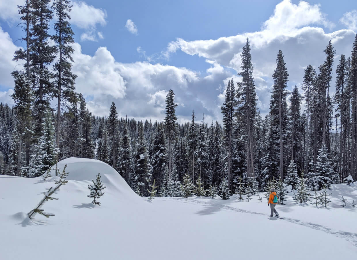
The Quick Silver Trail is another excellent beginner’s trail at Nickel Plate Nordic Centre. It is best travelled in a counter clockwise direction.
Like the Gold Dust Trail, this route traverses open meadow areas (see photo below) as well as thick forest. It has slightly more elevation gain, however, over a shorter distance.
This trail crosses and passes alongside a number of cross country ski trails – be sure to step over the established tracks carefully to avoid impairing the route for skiers.
Please note that the Quick Silver Trail requires a day pass to snowshoe, which can be purchased online or at the ticket both. Nickel Plate Nordic Centre also rents snowshoes, in both adult and youth sizes.

Trailhead details
Location: Nickel Plate Nordic Centre
Directions: 6.5 kms past Apex Mountain Resort on the Hedley/Nickel Plate Road, west of Penticton. It is well signed
Drive time: Allow 50 minutes for the drive from downtown Penticton

Snowflake Loop, Okanagan Vista Cross Country Ski Trails System
Trail length: 2.9km
Time: 1.5 hours
Elevation gain: Minimal
When to go: Late November to early April
Parking: Large off road parking area (size varies on recent snowfall)
Facilities: None
Signage: Maps at trail junctions, additional signage
Navigation: Official map, Maps.me, AllTrails
Dogs: Allowed
The Snowflake Loop is a wonderful, short loop trail ideal for anyone trying out snowshoeing for the first time.
The access can be a little steep, then the trail almost completely flattens out as it weaves between trees and snow covered ponds.
A worthy extension to this short loop is the Lake Connector, which travels downhill to frozen Nickel Plate Lake (additional 530m each way).
Please keep in mind that this recreational area is primarily maintained for cross country skiing. Keep an eye out for established ski tracks and avoid stepping on them as much as possible.

Trailhead details
Location: Close to Nickel Plate Nordic Centre
Directions: 2.8km kms past Apex Mountain Resort on the Hedley/Nickel Plate Road, west of Penticton. The parking area is on the right hand side of the road
Drive time: Allow 45 minutes for the drive from downtown Penticton
GPS coordinates: 49°24’05.9″N 119°55’27.7″W

More places to go snowshoeing in Penticton
While the above five locations are my favourite places to go snowshoeing in Penticton, they are not the only options.
I’m actively researching to find more to add to this post, so if you have any suggestions that you are willing to share, please let me know in the comments below!
After a heavy snow at low elevations, the Kettle Valley Rail (KVR) Trail can be a great choice for snowshoeing in Penticton. The sections closer to town tend to get tracked out pretty fast though, so you’d have to be quick!
Most of the time, snowshoes are not needed on the lower elevation stretches of the KVR (such as Vancouver Place to McCulloch Trestle or along Skaha Lake) – a decent pair of hikers will do, with micro spikes if conditions are icy.

Check out these related posts next:
What to Do in Penticton in Winter: A Local’s Guide
16 Fast and Fun Hikes in Penticton
A Local’s Guide to Craft Breweries in Penticton
74 Things To Do In Penticton and the Southern Okanagan
What to Do On a Rainy Day in Penticton
The Best Restaurant Patios in Penticton

One half of the Canadian/British couple behind Off Track Travel, Gemma is happiest when hiking on the trail or planning the next big travel adventure. JR and Gemma are currently based in the beautiful Okanagan Valley, British Columbia, Canada. Consider buying us a coffee if you have find any of our guides helpful!
Adding this comment from Celine –
Hi there!
Great post, helpful, as always
I would also add the Chute lake area. There is a great short hike with a bit of elevation just by the sign before you arrive at the lodge. Depending on the day I decide to either just go to the viewpoint and back or take the longer loop that takes you along the ridge and then back down to the KVR.
They have a map at the lodge I believe.
It’s a beautiful trail and the perk of stopping for a board game and a hot drink by the fireplace after makes it even more exceptional.
Other options from the lodge are to go on the KVR or to Elinor lake.
Happy snowshoeing adventures!!
Hello! Can you provide more details about the Okanagan Vista trail system? Is snowshoeing allowed on all the trails? Or only the snowflake loop? Are dogs allowed?
Do you have any recommendations for intermediate or advanced snowshoe trails in the area?
Thank you!
Hi Michael,
Yes, of course! Snowshoers are welcome on the trails but are asked not to snowshoe on ski tracks. Dogs are not prohibited.
The Okanagan Vista area has some higher level trails, as does Carmi Recreation Area.