The Northumberland Coast Path is a 100km long journey along some of England’s most beautiful shorelines.
The trail starts in the tiny seaside village of Cresswell and ends in historic Berwick-upon-Tweed, just below the Scottish border.
Most of the route stays very close to the North Sea, with many long coastal stretches traversing gorgeous sandy beaches, sand dunes and rocky headlands.
With three imposing castles directly on the route and one more close by, stone towers are a familiar sight on the horizon throughout most of the trek.

Offering a blend of pristine coastal scenery, rich history and coastal village comforts (pubs, seafood, cosy accommodation), the Northumberland Coast Path is an unforgettable picture-perfect coastal walking experience.
We walked the entirety of the Northumberland Coast Path in May 2023. Initially attracted to the area by the formidable-looking castles, we were left captivated by the scenery, particularly the abundance of unspoiled (and quiet!) beaches.

In this post, I share our day-by-day experience of walking the Northumberland Coast Path.
It is followed by a comprehensive hiking guide that includes the details you need to know to walk the Coast Path yourself, including where to stay, the best places to see and eat, suggested itineraries, safety tips and more.
Published October 2023. This post includes some affiliate links. If you make a purchase via one of these links, I may receive a small percentage of the sale at no extra cost to you.

The Northumberland Coast Path
The Northumberland Coast Path is situated in the northeast of England, close to the Scottish border.
For the most part, the 100km (62 mile) long trail hugs the North Sea shoreline, only turning inland for a short time between Belford and Fenwick.

The total elevation gain is 740m along the entire route, meaning that the terrain is pretty level overall. Think easy coastal walking with big skies and panoramic coastal views.
The Northumberland Coast Path can be explored as a thru-hike (5 to 7 days, 14-20km/day) or on shorter day walks. Good public transportation links make travelling between different sections of the Coast Path relatively easy.

Northumberland Coast Path history
The Northumberland Coast was designated as an Area of Outstanding Natural Beauty in 1958. I haven’t been able to determine when the Northumberland Coast Path came into being, but Iain Robson, AONB Manager, is attributed as the developer.
The scenic coastline is only half the story of this long-distance pathway. Northumberland is England’s most northerly county and has a rich history dating back thousands of years.

A wild frontierland during the Roman occupation, Hadrian’s Wall was constructed on what is now Northumberland’s southern border.
The first Christian monastery in England was established in 634AD on the Holy Island of Lindisfarne, a tidal island situated close to Berwick-upon-Tweed.
Lindisfarne Abbey was later destroyed by Vikings and rebuilt during the Norman era. It has since fallen into ruin again.
The founder of Lindisfarne was Saint Cuthbert, who some call the most famous Northumbrian. Indeed, his legacy is found across the Northumberland Coast Path.
Northumberland’s position as a battleground between the English and Scots led to the construction of many castles, the most of any county in England.
Warkworth Castle, Dunstanburgh Castle and Bamburgh Castle are directly located on the Northumberland Coastal Path. Lindisfarne Castle can also be seen while walking the northern sections.
While not a castle, the trail also passes close to Howick Hall, the home of Earl Grey tea.
Today, Northumberland has a population of 320k people. The county is a popular holiday destination, with more than a million British visitors (plus around 50,000 international tourists) each year.
Other significant industries include health (particularly pharmaceuticals), manufacturing and agriculture.

Northumberland Coast Path Walking Experience
We walked the Northumberland Coast Path over five days in late May. Basing ourselves in a rental cottage just outside of Alnmouth, we primarily used buses to travel to each section of the trail.
My parents had driven up with us from Hampshire and kindly offered a couple of lifts to some of the harder-to-reach spots. We also used the train a few times.
Preferring to choose the best section to walk according to the weather, we completed the Coast Path out of order and in both directions (south and north).
Originally, we were going to hike the trail over six days, averaging 16km a day.
We changed our mind, however, when the weather turned unseasonably warm and sunny. The idea of having some time off to enjoy the sunshine was very tempting so we decided to push through and finish in five days instead.
In addition to the mileage below, we walked an additional 10km off trail (travelling to and from our rental accommodation/bus stops/railway stations).

Day 1: Seahouses to Belford (10.3 miles / 16.5km)
Our Northumberland Coast Path experience started in an unusual way – at the midpoint and with a wildlife tour!
The Farne Islands lie just offshore of Seahouses and are home to over 100,000 seabirds. This resident bird population includes Atlantic Puffins (my favourite) Common Guillemots and Razorbills.

We joined one of Billy Shiel‘s two-hour boat tours, which offered the chance to see many colonies of birds as well as the Chapel of St Cuthbert and Prior Castell’s Tower. We were also followed by a pod of dolphins at one point!
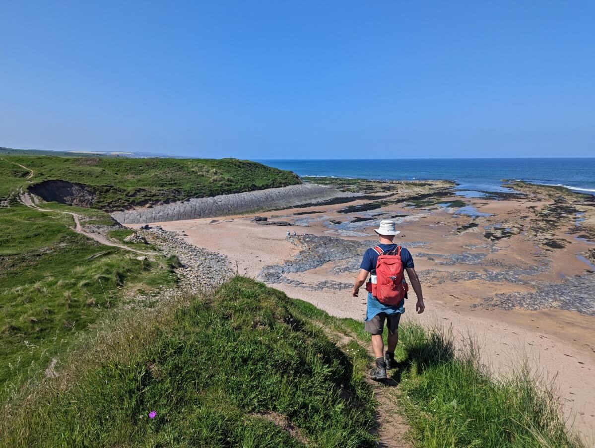
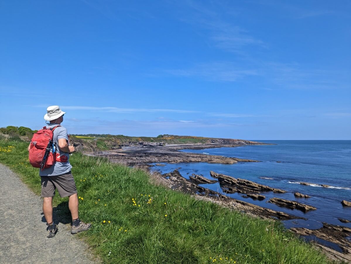
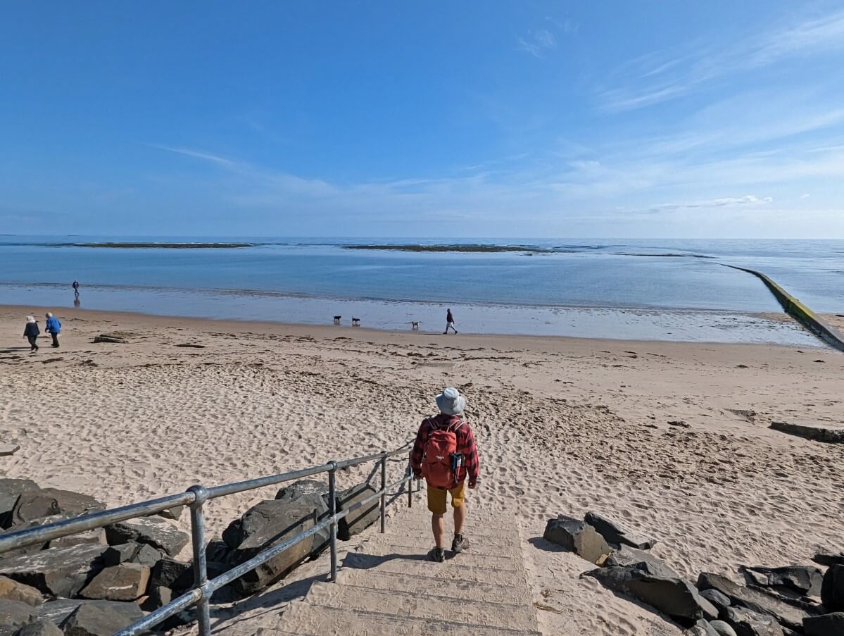
Back on dry land, it was time to start the Coast Path! We headed straight onto the beach and walked 4 miles along the sand towards the imposing Bamburgh Castle.

Some claim Bamburgh Beach to be the best in the entire UK and I agree that it is a very strong contender with soft golden sand, grassy dunes and a 900-year-old castle as a backdrop. Beautiful, but a bit hot in the afternoon sun!
Leaving my parents in Bamburgh (they caught the bus back to Seahouses), we continued on towards Belford, via a meandering trail along Budle Bay.

We were treated to impressive views of the castle and the North Sea as well as a close-up encounter with a WWII pillbox (bunker).
Turning inland, the trail weaved through a number of fields, along some quiet(ish) roads and across the railway.
The meandering route threw off my calculations and we had to run to catch the X18 bus to Berwick-upon-Tweed. We returned to Alnmouth via the train. A bit of a roundabout day but a good one!

Day 2: Belford to Fenwick A1 (7.1 miles / 11.4km and Seahouses to High Newton-by-the-Sea (4.5 miles / 7.2km)
With the forecast for the next day looking a bit wet and cloudy, we thought it better to stay inland and ‘save’ the beach sections for later.
Travelling back to yesterday’s finishing point via bus meant we had a late start (10.45 am). The grey skies turned darker and darker as we left Belford’s Market Place.

Sheep, cows, bright yellow broom and delicate bluebells lined our route up and across the fields, later replaced by endless stacks of cut logs on the outskirts of Swinhoe Farm.
Somewhere around this point, we missed the turn-off to St Cuthbert’s Cave, an overhanging outcrop of sandstone rock said to be the place where Lindisfarne monks laid St Cuthbert’s body to rest in AD875.

Unfortunately, we were almost two miles away before we realised and, by then, it felt too far to turn back. Darn!
We commiserated our mistake with delicious cake in the Guru Coffee Shop in Fenwick. With extra time on our hands, we decided to take the opportunity to walk another section of the Coast Path.
The X18 bus transported us to Seahouses and from there we decided to see how far south we could go.

With the weather brightening up, it turned out to be a lovely coastal stroll. We could see Bamburgh Castle behind us and an endless series of golden sand beaches ahead. Bliss!
We eventually called it quits at Newton Steads and turned inland to High Newton. Though off route, High Newton was a convenient place to catch the 418 bus back to Alnmouth.

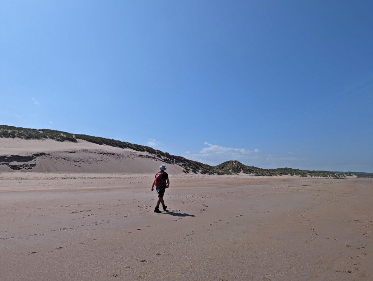
Day 3: Cresswell to Alnmouth (15.8 miles / 25.4km)
Offered a lift to Cresswell the next morning by my parents, it was time to see the official ‘start’ of the Coast Path! And what a beginning it is!
The trailhead signage points down a short access path to the most gorgeous 11km long golden sand beach.
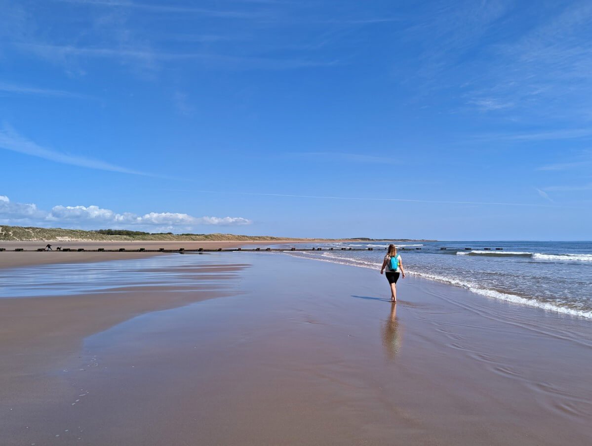
We spent the next 3 hours struggling to comprehend how lucky we were to be walking along Druridge Bay Beach on the most spectacularly sunny spring day.
The ocean was calm, the sand squeaky, the sky deep blue with only a smattering of clouds….it was just perfect.

We stopped for a break next to a line of WWII anti-tank defences. These huge concrete blocks are present on many of Northumberland’s beaches as this area was considered a potential target for German invasion.
With the tides in our favour, we were able to walk on the beach all the way to the outskirts of Amble.

After a quick walk on the south pier, it was time for our much-anticipated fish and chips lunch followed by an ice cream from Spurreli’s. We also dropped by the lobster hatchery to look at tiny newborn ‘bugs.’
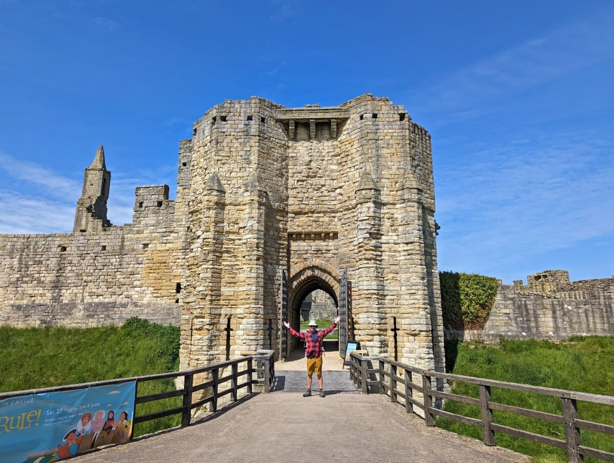
Our day would get better still as we headed towards Warkworth, host of our first castle visit. My parents met up with us for a walk around the grounds of the 600-year-old hilltop medieval castle. I found it to be well worth the entry fee.
Our home stretch to Alnmouth started with a crossing of a fortified bridge (a similar age to the castle). After a short stretch on yet another beautiful beach, we followed the path behind the sand dunes.
The pretty village of Alnmouth was soon visible on the other side of the river mouth. Lucky for us, we didn’t have to walk all the way into town. This was a loooong day but a really fun one (and probably my favourite).

Day 4: Alnmouth to High Newton-by-the-Sea (12.9 miles / 20.7km)
Waking up to another blue sky day, we were excited to get started. A beautiful golden sand beach, again lined with WWII anti-tank blocks, greeted us on the other side of the picture-perfect village of Alnmouth.

The beach led us (via a short detour through a caravan park) to Boulmer, a pretty fishing community.
Though it seems unlikely today, Boulmer was once a smuggling hotspot, most notably for gin.
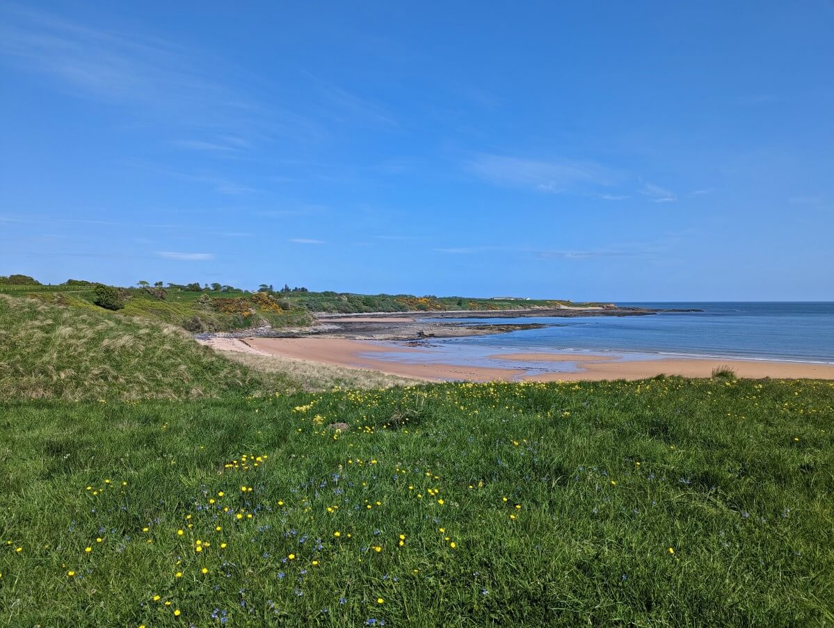
The following section of the Coast Path featured some of the most interesting terrain along the entire route.
Imagine pristine sandy bays punctuated with rocky bays and basalt columns, bordered by bright yellow broom. The path winds right alongside it all but remains relatively level and never steep.
We spotted dolphins playing in the sea no less than three times. This was truly a glorious morning on the Northumberland Coast Path!

It was bettered still by our lunchtime arrival in Craster. I’d heard that crab sandwiches at the Jolly Fisherman were a must.
We’d arrived too late (12.15pm!) to secure a seat on the sunny patio, but no matter, the food and cider tasted just as good inside.
The weather was turning as we stopped to buy some famous smoked kippers at L. Robson & Sons on our way out of Craster. By the time we reached the ruins of Dunstanburgh Castle, the skies were pretty gloomy.

This striking castle looks more impressive from a distance, but we still had fun exploring the crumbling towers. The basalt cliffs below the castle are a fabulous vantage point for birdwatching.
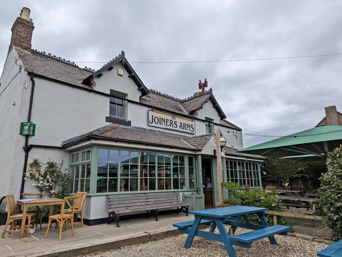
Through another golf course, along a few more stretches of beach and we were done for the day. Instead of having to catch a bus, we enjoyed a drink at the Joiners Arms in High Newton while waiting for my parents.

Day 5: Fenwick A1 to Berwick-upon-Tweed (11.7 miles / 18.8km)
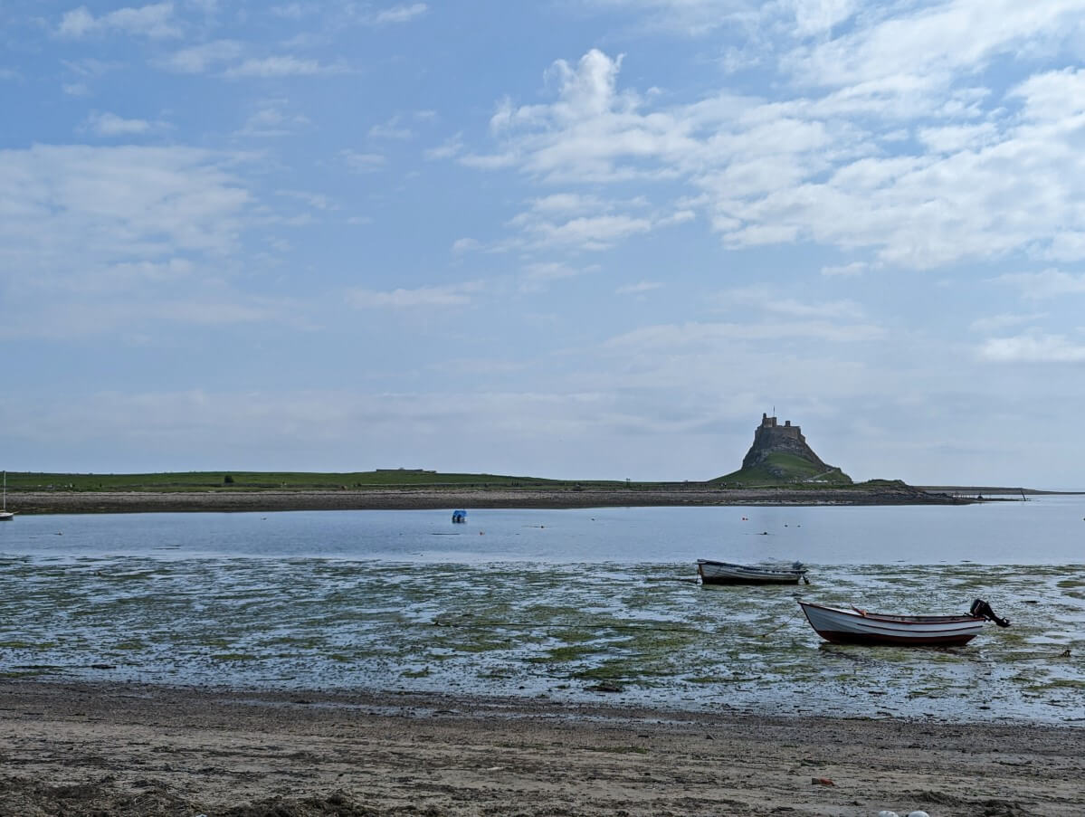
Our final day on the Northumberland Coast Path started with a (road) trip to the Holy Island of Lindisfarne, a tidal island not far from Fenwick.
A short circular walk later (taking in views of Lindisfarne Priory, Lindisfarne Castle, coast and village), my parents dropped us off at the A1 near Fenwick to continue our Coast Path adventure.

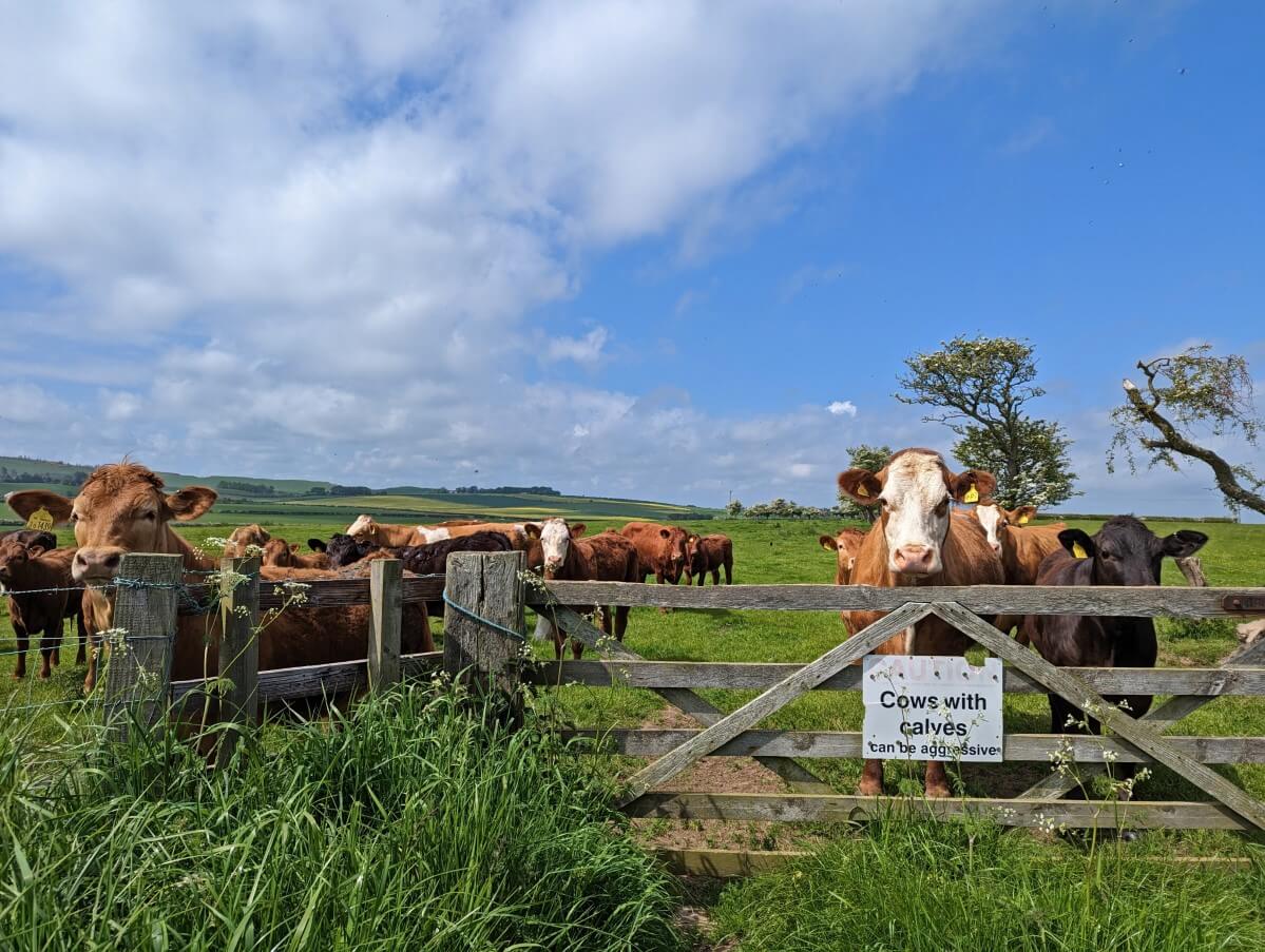
The grassy path gained a little elevation as it traversed between cow fields.
We crossed a railway line (with a train passing through about 4 minutes later!) and soon arrived back at the Holy Island causeway via a path lined by more WWII anti-tank blocks.
There’s no other word for the next section of the trail but wet. Luckily, it didn’t last long and we were distracted by another pillbox fortification.

Feet mostly dry, we emerged next to spectacular Goswick Beach. Perhaps blinded by the golden sand, we missed the turn-off.
We ended up further and further away from the sea, with the only access points marked as having dangerous ordnance and quicksand (?!)
We eventually made it back via a paved road and enjoyed more wonderful beach walking along Cheswick Sands.
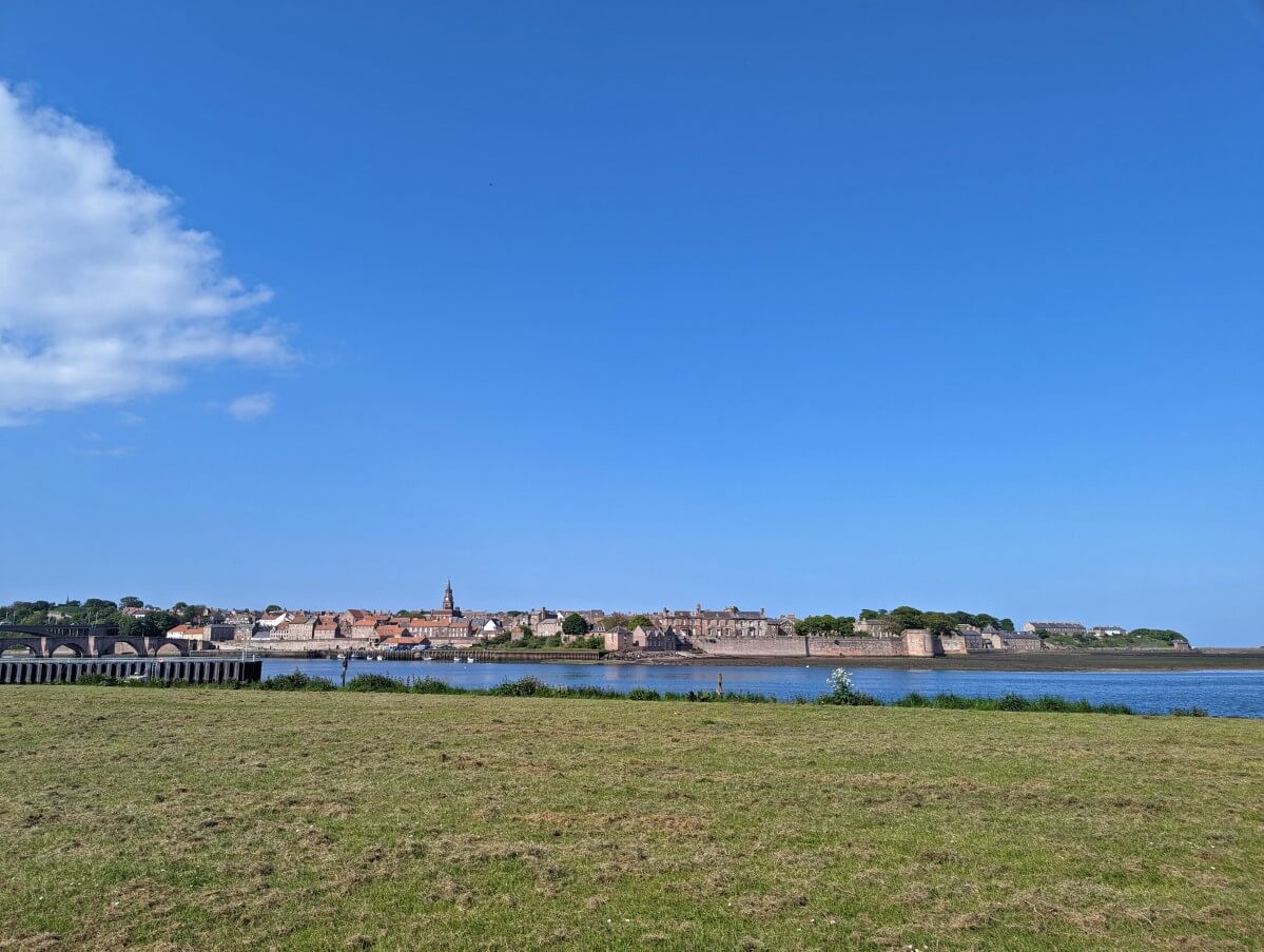
Getting turned around cost us significant time. Consequently, we had to speed walk the final 6km into Berwick-upon-Tweed to reach the Tourist Information Centre before it closed.
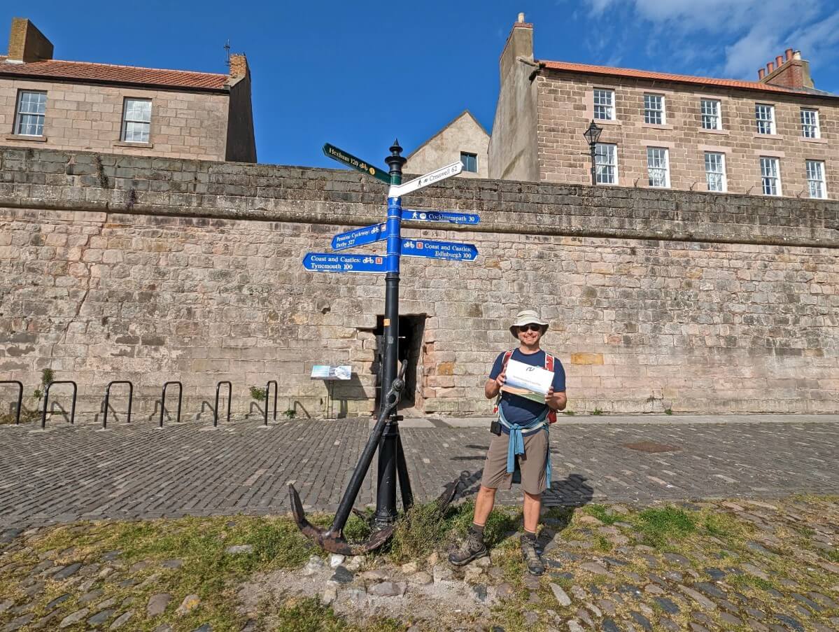
While this wasn’t the ending that we wanted, it was still an incredible finale to a truly fantastic walk. The walled city of Berwick-upon-Tweed is even more impressive when approached on foot.
Finishing certificate in hand, we retraced our steps to find the northern trailhead sign on the Quayside and then headed to the Curfew Micropub for our free celebratory half pint of real ale (or in my case, cider).
We returned to Alnmouth via the train, thankful for the spectacular walking route that is the Northumberland Coast Path.
Northumberland Coast Path: Our thoughts
With warm temperatures, sunny skies and spring flowers everywhere, we had the best conditions imaginable for our walk on the Northumberland Coast Path.
We saw so much wildlife (nesting birds, pheasants, dolphins and more) and enjoyed solitude on empty beaches.
The North Sea was calm and sparkled turquoise in places. Our waterproof jackets only came out of our backpacks once. Honestly, I almost had to pinch myself to make sure we were still in England.

Simply put, our walk on the Northumberland Coast Path was nothing short of delightful.
Even without the pleasant weather, however, I still think I would have loved this trail. The beaches were definitely a highlight, but we also enjoyed seeing so many castles, exploring the coastal villages and eating local seafood.
The only real downside was the long-ish days (averaging 20km), which we had to balance with bus and train schedules. The bus network is pretty good in this area but I would have preferred more time on the trail and less on the bus.

This is the second time we have walked a long-distance trail with the help of public transportation (the first time was on the Isle of Wight Coastal Path).
While I like the freedom a good bus service can offer (switching sections, having a base), it does deduct significant time from the day.
Looking for more UK long-distance walking inspiration? We have also walked the South Downs Way and the Great Stones Way

Northumberland Coast Path Hiking Guide
The rest of this post will concentrate on the planning and logistics required to walk the Northumberland Coast Path. You can skip to any of the following sections by clicking below:
Walking necessities
- Always bring the 10 Essentials
- Know how to stay safe
- Remember to Leave No Trace
- Recommended gear is listed on our Resources page
- Need a multi-day hiking packing list? Sign up to our newsletter for a free one!
How long is the Northumberland Coast Path?
The Northumberland Coast Path is 62 miles or 100km long.
From my research, it seems that most Coast Path walkers finish the trail in 5 days (20km/day) or 6 days (16km/day).
Walkers planning to stay overnight along the route may need to hike further to reach nearby accommodation. In that case, plan to walk an extra 10km (6 miles) or so (110km total).

Where does the Northumberland Coast Path start and end?
The Northumberland Coast Path’s southern trailhead is located in the coastal village of Cresswell. There is trail signage on the beach access pathway just to the right of Cresswell Ices.
Cresswell is super picturesque but very small (pop 200) and services are therefore limited. There are public toilets close to the trailhead. Cresswell has some options for free long-term parking, though I’d suggest parking in Berwick instead.
If you don’t have a vehicle, Cresswell is accessible from Newcastle or Berwick-upon-Tweed via two buses or a train/taxi combination.
The cheapest way to reach Cresswell from Newcastle is to take the X22 bus to Ashington and then catch the 1 bus to Cresswell Crows Nest. Both buses run once an hour on weekdays.
The northern trailhead is situated in the historic town of Berwick-upon-Tweed, close to the Scottish border. There is trail signage atop an anchor in the Quayside area, a short walk from the Old Bridge.
This trailhead is not as obvious to find as we expected (here are the exact GPS coordinates). There are a couple of options for long-term parking nearby.
Home to 13k people, Berwick offers plenty of shops, restaurants and places to stay.
Berwick is also well-connected by public transportation. Newcastle is accessible via bus (X18 and X15 services) and train. Edinburgh is only 40 minutes by train to the north.

Which way to walk the Northumberland Coast Path?
It is possible to walk the Northumberland Coast Path in either direction – north or south.
The official Northumberland Coast Path website suggests south to north to have the sun at your back while walking. This direction also takes advantage of the prevailing winds.
I think this is a fair evaluation, but honestly, I think either way is fine. We walked in both directions during our hike as we needed to plan our trip around bus schedules.

In my opinion, one of the most special aspects of the Northumberland Coastal Path is being able to look ahead and spot one of the castles on the trail. Thankfully, this is possible in either direction!
Another consideration would be your finishing point. I really enjoyed ending our walk in Berwick-upon-Tweed and receiving both a finishing certificate (at the tourist info centre) and a celebratory half-pint (at the Curfew Micropub).
Cresswell is a cute place but I think it would be a little anti-climatic to finish there, especially as there are limited places to eat.
The Northumberland Coast Path guidebook is written from south to north.

Navigating the Northumberland Coast Path
The Northumberland Coast Path is an established and well-used trail. It is a blend of existing pathways and bridleways.
The terrain is mixed. Some sections are mostly dirt pathways and grass tracks, and others utilise paved pedestrian walkways and minor roads.
Signage
The route is marked with circular blue Coast Path signs and larger blue signposts, both displaying a large ‘N’ logo (for Northumberland).
Between Warkworth and the Holy Island causeway, the circular signs also feature the St Oswald’s Way text and logo as the path is shared by both routes.
St Cuthbert’s Way signs also appear between Fenwick and the Holy Island causeway.
The Northumberland Coast Path is part of the England Coast Path and many of the larger wooden signs promote this. Look for the large ‘N.’

Overall, we found the Coast Path to be pretty well signed.
Having said that, we did have some navigational issues in three places:
- Around the Nanny Burn near Beadnell (we just weren’t sure where to go)
- Between Bamburgh and Belford (some of the junctions were missing signs)
- Goswick Sands (we missed the chance to exit onto the beach)
Beach alternatives
We spent as much time as possible walking on the beach. The official routing goes further inland in quite a few places (notably in Seahouses).
The guidebook mentions beach alternatives and we took these at every opportunity.
Due to this, one aspect we did find sometimes confusing was where/when to get off the beach. With a bit of trial and error, however, we always worked it out.
It helped that it was low tide during most of our walking hours. We would have had to be more careful during high tide.
The great thing about the Northumberland Coast Path is that the North Sea is almost always on your right (northbound) or left (southbound). It takes a lot of the difficulty out of navigation in certain areas.

Resources
I downloaded a GPX route from the Walking Englishman and found it helpful to use as a backup. The maps in the official Northumberland Coast Path guidebook were useful too.
The Northumberland Coast Path is featured on the following OS Explorer maps – Morpeth and Blyth (Cresswell area), Alnwick and Amble, Holy Island and Bamburgh and Berwick-upon-Tweed.

Public transportation on the Northumberland Coast Path
The Northumberland Coastal Path is reasonably well connected by bus. A local train line also provides transportation options.
The X18 Arriva bus travels between Newcastle and Berwick-upon-Tweed via Amble, Warkworth, Alnwick and the middle section of the Coastal Path (Belford to Boulmer) three times a day from Monday to Saturday. There are additional services between Newcastle and Alnmouth as well.
When we hiked the Coastal Path, the middle section was well-serviced by the 418 Travelsure bus.
Travelsure’s owners retired at the end of 2023 and Border Buses now operates the 0418 service between Alnwick and Wooler via Belford, Bamburgh, Seahouses and Craster.
The bus runs three times a day in either direction. Unlike the Travelsure service, however, there are no links to Alnmouth Railway Station.
On the upside, Border Buses has another new route that may be helpful to Northumberland hikers – the 0918. This two-a-day service operates between Belford, Bamburgh, Seahouses, Craster, Beadnell and Chathill Railway Station.

The X15 Arriva bus also operates between Newcastle and Berwick-upon-Tweed but avoids much of the coastline. For Coast Path walkers, it is most useful when travelling between Alnwick, Belford, Fenwick and Berwick.
The X20 Arriva bus runs between Newcastle and Alnwick via Hipsburn (near Alnmouth), Amble and Warkworth.
These five bus routes provide access to most communities along the Northumberland Coast Path, with the village of Cresswell being the major outlier.
The X20 service comes the closest, passing through nearby Ellington (1.6 miles / 2.5km away).
Arriva/Border Buses bus tickets are interchangeable and are currently £2/journey within the North Northumberland area (Amble to Berwick), with all-day tickets priced at £6.70. A seven-day pass is £23.00.
In 2025, a single bus journey ticket will rise to £3.
Berwick-upon-Tweed, Alnmouth and Newcastle are also connected by train, with one service at least every two hours.

Where to stay on the Northumberland Coast Path
Northumberland is a very popular holiday destination. A variety of accommodation is available in many different communities along the Northumberland Coast Path route.
The most common types of accommodation are holiday rentals, small inns/guesthouses, campgrounds and B&Bs. The only large hotels are found in Alnwick.
Finding accommodation is one of the most difficult aspects to organising a thru-hike of the Northumberland Coast Path. Due to the popularity of the area, many accommodation providers do not offer one night stays.

For that reason, it may prove to be a better idea to base yourself in one or two locations and drive or use public transport to reach different sections of the trail (as we did).
I would recommend using public transport as much as possible as car parking is very limited (and expensive!) in some areas. Of course, it’s better for the environment too.
We based ourselves close to Alnmouth Railway Station for the entirety of our walk and managed to get around the majority of the route via bus and train.
If you’re planning to walk the entire route, I would suggest Alnwick as an alternative base location. It has the best bus connections overall.

Just walking short sections of the Coast Path? I would recommend staying in one of the smaller coastal communities such as Bamburgh, Seahouses, Beadnell, Craster, Embleton, High Newton or Low Newton and using the 418 bus to get around.
Amble may also work well, though the bus connections (via Alnwick) would take longer.
Accommodation recommendations
We rented Dorothy’s Cottage at Bilton Barns Farm near Alnmouth for our week-long stay in Northumberland. This three-bedroom, two-bathroom self-catering property was the perfect size for our group. We paid £760 for one week.
While the cottage isn’t on the Coast Path itself, it is just one mile (1.6km) from Alnmouth Railway Station and the Curly Lane 418 bus stop.
The village of Alnmouth is 2 miles away from Bilton Barns. The only place we had difficulty accessing was Cresswell (my parents gave us a lift), but we could have managed it with two buses.
Bilton Barns has a range of other self-catering properties available for rental.
Before I booked Bilton Barns as a base, I had planned the following thru-hike itinerary with overnight accommodation:
- Cresswell to Warkworth – 10.5 miles / 16.8km – overnight at the Sun Hotel (around £130/night with breakfast included)
- Warkworth to Craster – 13 miles / 20.4km – overnight at the Cottage Inn Hotel (around £100/night with breakfast included)
- Craster to Seahouses – 10 miles / 16km – overnight at the Links Hotel (around £110/night)
- Seahouses to Belford – 11 miles / 17.5km – overnight at the Blue Bell Hotel (around £100/night)
- Belford to Beal (off route) – 8 miles / 12.8km – overnight at the Lindisfarne Inn (around £160/night with breakfast included)
- Beal (off route) to Berwick – 14 miles – 22.5km – overnight at the Kings Arms Hotel (around £100/night)

Camping on the Northumberland Coast Path
There are some private campgrounds close to the Coast Path.
When originally planning to camp, I noted the following campgrounds:
- Druridge Bay Country Park Campsite between Cresswell and Amble
- Coast and Castles Camping near Boulmer
- Beadnell Bay Camping and Caravanning Club Site
- Budle Bay Campsite near Bamburgh
- The Barn at Beal Campsite near Fenwick
Please note that wild camping is only allowed with the permission of the landowner.

Suggested Northumberland Coast Path itineraries
Deciding where to walk on the morning of each day, we followed a pretty unconventional itinerary while walking the Northumberland Coast Path.
Six day itinerary
A more standard Northumberland Coast Path itinerary would look like this:
- Cresswell to Warkworth – 10.5 miles / 16.8km
- Warkworth to Craster – 13 miles / 20.4km
- Craster to Seahouses – 10 miles / 16km
- Seahouses to Belford – 11 miles / 17.5km
- Belford to Fenwick – 6 miles / 10.3km
- Fenwick to Berwick-upon-Tweed – 12 miles – 19.5km
This divides the walk into six fairly even walking days, with the exception of the Belford to Fenwick section, which is a little short.
Of course, this itinerary relies on being able to book accommodation in each locale for one night (which can be a tricky prospect) or using two vehicles/buses to reach each trailhead.
Five day itinerary
It is possible to walk the Northumberland Coast Path in five days, as we did. In that case, I would suggest:
- Cresswell to Warkworth – 10.5 miles / 16.8km
- Warkworth to Craster – 13 miles / 20.4km
- Craster to Bamburgh – 13.8 miles / 22.3km
- Bamburgh to Fenwick – 13.2 miles / 21.2km
- Fenwick to Berwick-upon-Tweed – 12 miles / 19.5km
Six day itinerary with castle visits
If you are prioritising visiting the spectacular castles en route, I would suggest this six-day itinerary:
- Cresswell to Warkworth – 10.5 miles / 16.8km (visit Warkworth castle late in the afternoon or early the next morning)
- Warkworth to Craster – 13 miles / 20.4km
- Craster to Seahouses – 10 miles / 16km (visit Dunstanburgh Castle early in the morning)
- Seahouses to Bamburgh – 4 miles / 6.4km (visit Bamburgh Castle in afternoon)
- Bamburgh to Fenwick – 13.2 miles / 21.2km
- Fenwick to Berwick-upon-Tweed – 12 miles – 19.5km
The above itinerary would should also allow enough time to join a morning Farne Islands boat tour from Seahouses on day 4.
As previously mentioned, the public transportation system in the Northumberland area makes it possible to walk sections of the Coast Path in any direction/order you like.
Holy Island
Whatever itinerary you choose, I would recommend setting aside one additional day to visit the Holy Island of Lindisfarne.
The island is accessible by bus, vehicle or even by foot (6 miles return, prepare for muddy legs). Be sure to plan your visit very carefully according to the tides!

Where to eat and drink on the Northumberland Coast Path
There are so many great places to eat on the Northumberland Coast Path! This is especially true if you like seafood.
Local specialities include fish and chips, crab (often in sandwiches), smoked kippers and oysters.
Also look out for singin’ hinnies (a type of scone), locally made Doddington Dairy ice cream, stotties (a type of flatbread), pease pudding (like a thick split pea soup with ham), pan haggerty (potato, onion and cheese casserole) and Lindisfarne mead.

A long-distance walk in the UK is not complete without refreshments at a pub or two. Some of the best along the Northumberland Coast Path are:
- The Red Lion Inn in Alnmouth
- The Jolly Fisherman Inn in Craster (crab sandwiches are a must!)
- The Ship Inn in Low Newton
- The Bamburgh Castle Inn in Seahouses
- The Curfew Micropub in Berwick-upon-Tweed
We also enjoyed the Joiners Arms in High Newton. In Fenwick, we stopped at the excellent Guru Coffee Shop for lunch.
There are many options for takeaway fish and chips in both Amble and Seahouses. We liked Quayside Fish & Chips and Harbour Fish Bar in Amble (yes, we tried two!)
L. Robson & Sons is a must-stop in Craster for anyone who likes smoked fish. They have been producing Craster kippers for almost 100 years.

Spurreli’s serves amazingly luxurious ice cream in Amble. If visiting Holy Island, be sure to try Pilgrims Fudge Kitchen and Gelateria (especially if you have any vegan or dairy-intolerant folks in your group)
We would have loved to try Creel & Reel Seafood Trailer in Bamburgh but it was closed on the day we passed by.
Some of the smaller coastal villages (Boulmer, Cresswell, Beadnell, Craster) have only a few restaurants or none at all. Be sure to plan ahead and consider bringing a packed lunch (we did this a few times).
There are convenience stores in Amble, Seahouses, Beadnell and Spittal (near Berwick). Warkworth and Alnmouth have small village stores.
What is the weather like on the Northumberland Coast Path?
The UK has a temperate climate. Winters are cold and wet, while summers are warm and humid (though drier than winter). Snow is possible in winter.
British weather is inherently unpredictable, however, with all manner of conditions (rain, cloud, fog, hail, sunshine and more) possible on the same day at any time of year!
Situated above 55° latitude (just below Scotland!) and next to the freezing North Sea, Northumberland is one of the coldest places in England. It is also, however, one of the driest places as well, receiving 650mm of rain annually.

Due to the cold nature of the North Sea, coastal fog (known locally as fret or sea fret) is commonly seen in spring and summer. So keep in mind that even if it is warm and sunny inland, it may be foggy and significantly cooler on the coast.
We visited Northumberland in May 2023 and experienced mostly sunny weather with daily temperatures around 18-22°C. This was very unusual for that time of year. The average high in May is typically 13°C!
Technically, the Northumberland Coast Path can be walked all year round. For most people, though, the best time would be April to October, when the weather is warmer and drier and the daylight hours are longer.
Most accommodation, restaurants and attractions will be open during this time as well.
The warmest and driest weather is usually experienced in June, July and August. Northumberland is busiest during this time and accommodation prices are therefore high.

What to see on the Northumberland Coast Path
Besides taking in the incredible coastal scenery, there are a number of nearby attractions that you may want to visit while walking the Northumberland Coast Path.
The route also passes through the beautiful coastal villages of Amble, Warkworth, Alnmouth, Craster, Seahouses, Boulmer, Low Newton, Bamburgh and Belford as well as the historic walled town of Berwick-upon-Tweed.

Guided hike and luggage transportation options on the Northumberland Coast Path
It is possible to book self-guided walking tours along the Northumberland Coastal Path.
Most tours will include pre-booked accommodation, luggage transfers, detailed daily itineraries and some food (typically just breakfast). This is a good option for anyone who doesn’t have the time or interest to organise the details of a walking trip.
An alternative is to use a luggage transfer service only. If you’re changing accommodation each day, this is a great way to reduce the weight you are carrying. Carrylite offers this service for £10 per bag, per stage, with a two-bag minimum.

Day walks on the Northumberland Coast Path
Many sections of the Northumberland Coast Path are perfect for short day walks. Indeed, we met many people walking short sections and no-one else walking the full distance!
Here are my recommendations for the best day walks on the Northumberland Coast Path (in distance order):
One vehicle routes
- Amble to Warkworth – 2 miles (paid parking in Amble, take X18 bus or walk 2 miles back to Amble)
- Craster to Dunstanburgh Castle and return – 2.6 miles (paid parking in Craster)
- Seahouses to Bamburgh – 4 miles (paid parking in Seahouses, take the X18 or 418 bus back to Seahouses when finished)
- High Newton to Craster – 5 miles (free parking in High Newton, walk to Craster, take 418 bus back to High Newton when finished)
- Beadnell to Bamburgh – 7 miles (free parking in Beadnell, take the X18 or 418 bus back to Beadnell when finished)
- Belford to Bamburgh – 7 miles (free street parking in Belford, take 418 bus back to Belford when finished)
- Belford to Cuthbert’s Cave and return – 7.5 miles (free street parking in Belford)
- Craster to Alnmouth – 8.5 miles (free parking at Alnmouth Station, take the 418 bus to Craster and walk back)
- Amble to Alnmouth – 9 miles (free parking at Alnmouth Station, walk into Alnmouth, take the X18 to Amble and walk back)
- Boulmer to High Newton – 9 miles (free parking at High Newton, take the 418 bus to Boulmer and walk back)
- Berwick-upon-Tweed to Cheswick Sands and return – 10 miles (paid parking in Berwick or free parking at Cheswick Sands Car Park)
For a longer walk, consider the following:
- Craster to Bamburgh – 14 miles (paid parking in Bamburgh, take 418 bus to Craster and walk back)
- Alnmouth to High Newton – 15 miles (free parking at Alnmouth Station, take 418 bus to High Newton and walk back)
Two vehicle routes
As well as any of the above routes, consider the following if you have two vehicles:
- Cheswick Sands to Berwick-upon-Tweed – 5 miles (free parking at Cheswick Sands Car Park, paid parking in Berwick)
- Cresswell to Amble – 8.7 miles (free parking in Creswell, paid parking in Amble)
- Craster to Bamburgh – 14 miles (paid parking in Craster and Bamburgh)
These distances are one-way (unless otherwise noted) and are approximate.

Safety tips
As destinations go, Northumberland is considered relatively safe. There is low crime activity in the area.
‘Civilisation’ is never too far away on the Coast Path but keep in mind that the phone signal can be a bit intermittent. Always tell someone where you’re going and when you plan to be back.
Some of the beaches are difficult to cross at high tide or during high winds. An alternative inland route is available in most instances but it is important to plan ahead. Keep away from cliff edges as much as possible.
Making the side trip to Holy Island? Double-check (and then check again) the tides first. Multiple groups of people are rescued every year from the causeway.

Northumberland is a popular holiday destination for dog owners. Off-leash dogs are therefore a very common sight along the Coastal Path, especially on the beaches. I am nervous around off-leash dogs but I found that the majority (99%) stayed far away from us so it wasn’t a problem.
Unlike some other long-distance walks we’ve tried in the UK, the Northumberland Coastal Path has very few road walking sections without pavement (hooray!) The longest portions were between Bamburgh and Belford.

It is necessary to cross a couple of busy roads, most notably the A1 twice (near Belford then at Fenwick). Take your time!
The Coast Path passes through a number of golf courses (give way to golfers and watch for flying balls) and fields with cows (including bulls). If walking with a dog, keep them on a leash and under control.
Goswick Sands has unexploded ordnance (and quicksand!) on the southern end – look for the warning notices.
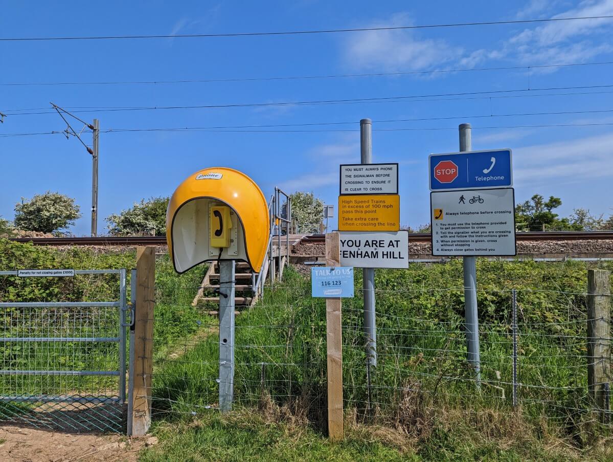
There are two railway crossings along the route. These require hikers to call the signaller (on the provided phone) for permission to cross.
Northumberland Coast Path Passport
A fun side activity while walking the Northumberland Coast Path is collecting stamps from participating ‘Welcome Port’ businesses.
There is an official Passport book available from the Northumberland AONB website for £2. The price includes a completion certificate (bargain!)
While I love the idea of the passport program, it does have some flaws. Since it is still relatively new, these may be ironed out in the coming years as the Coast Path becomes more popular.
The majority of the participating businesses are located along the southern half of the Coast Path. The lesson is to start collecting early!

Some participants are accommodation providers, which makes getting a stamp difficult if you’re not staying there.
A couple of the places we tried to visit were closed, either permanently or seasonally. Another was a listed participant but didn’t have a stamp.
In the end, we collected eight stamps – Spurrelli Ice Cream (so good!) in Amble, Puffin Stores in Alnmouth, the Jolly Fisherman in Craster, Bamburgh Castle Inn, Dunstanburgh Castle and the Joiner’s Arms in Newton-by-the-Sea.
We received a stamp and completion certificate from the friendly staff at Berwick Tourist Information Centre. Please note that it is located in the library building.
The Berwick Visitors Centre and Berwick Tourist Information Centre are different places (as we found out)!
Our final stamp was received at the Curfew Micropub in Berwick-upon-Tweed, where we also gifted a free half pint of real ale or cider of our choice. We paid the extra for a full pint to celebrate finishing the Coast Path!

Essential items
Personally, I never embark on any kind of long or challenging hike without a pair of hiking poles.
My preferred pair of poles is Black Diamond’s Distance Carbon Z – incredibly light, foldable and durable. We didn’t use them much on the Northumberland Coast Path but potentially may have done if the weather had been more inclement or the path muddier.

If you like background reading, check out the Northumberland Coast Path Recreational Path Guide by Roland Tarr or the Northumberland: the Coast book by Stephen Wood.
Be sure not to forget a sun hat and sun cream while hiking the Northumberland Coast Path. There is very little shade on this walking path and it would be so easy to get burned! This is true even when the sky is cloudy.
Waterproof top and bottom outer layers are an absolute must for hiking in the UK, especially in spring and autumn. My Arc’teryx Waterproof Jacket has not let me down yet. For trousers, I’d recommend the pull-on kind that are quick to put on and stash away small when not needed (like these ones – men’s | women’s)
Keep your phone and extra clothes safe from the rain in a dry bag. We also carried a rain cover for extra protection against the (almost non-existent!) wet weather.


One half of the Canadian/British couple behind Off Track Travel, Gemma is happiest when hiking on the trail or planning the next big travel adventure. JR and Gemma are currently based in the beautiful Okanagan Valley, British Columbia, Canada. Consider buying us a coffee if you have find any of our guides helpful!